question about Dennis 2005

This is the general tropical discussion area. Anyone can take their shot at predicting a storms path.

Moderator: S2k Moderators

Forum rules

The posts in this forum are NOT official forecasts and should not be used as such. They are just the opinion of the poster and may or may not be backed by sound meteorological data. They are NOT endorsed by any professional institution or STORM2K. For official information, please refer to products from the National Hurricane Center and National Weather Service.

Help Support Storm2K
Message
Author
MiamiensisWx

#21 Postby MiamiensisWx » Sat Dec 02, 2006 11:39 am

It's rather odd that no one really mentions Frances (2004). Had the mid-level trough over the Mississippi Valley and North Carolina (which weakened the upper-level ridging steering and resulted in the shear over Frances as it approached Florida) been weaker and more diffuse, the longwave ridging might have remained more deeply in place as Frances approached the Bahamas, resulting in a more southerly track into Fort Lauderdale/West Palm Beach metropolitan region, and the mid-level 30KT shear over the Bahamas that significantly weakened Frances might have never materialized significantly, so that outflow would actually be enhanced in what was already likely a near-perfect environment over Frances as it was north of the Leeward Islands and Puerto Rico (I have rarely seen such an enhanced outflow environment with good ridging support, with the exception of several other storms).

Had this materialized, Frances would have very likely been near a borderline Category Four/Category Five at Florida landfall due to excellent diffluence and upper-level ridging support and a more southerly track, which also would have supported a landfall in metropolitan Broward/Palm Beach. Contrary to what some believe, mid-level dry air intrusion was likely only a very minor factor in Frances' weakening on September 2 and September 3 in the Bahamas, and in fact, the eyewall was showing signs of tightening per satellite (and even RECON to some degree) and there was NO evidence of ANY ERC at all. Frances was already finished with it's ERC on September 1, which was at least one day earlier. With all that said, east-central and southeast Florida (especially the metropolitan areas and vicinities) likely came VERY close to seeing a 935 millibars or lower (120KT or higher) hurricane making landfall. The SST environment and heat content from PR to the Bahamas - as well as the Gulf Stream - would have only further enhanced this.

I know it's still a rather moot point, as the storm was still quite destructive, but I just found this interesting to bring up, as I find it unusual that Frances' weakening isn't recalled as often verbally.

Here, for example, is a shot of Frances (IR) on September 2. If viewed on a loop, you would note how outflow was attempting to expand, even up to the time of this image, and you would note the lack of ANY sign of an ERC or significant concentric eyewalls. If anything, the shear was the only significant factor that kept an intensification phase from occurring on September 2 and September 3.

Image

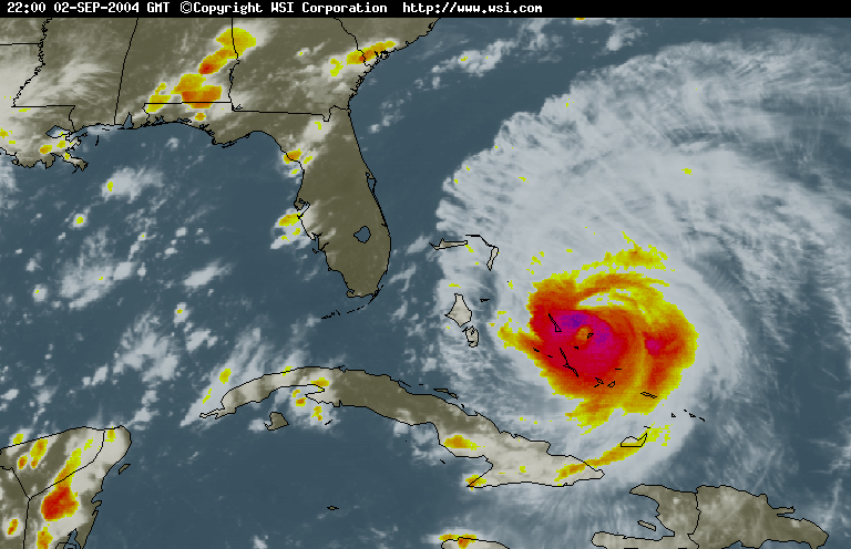
Note the middle to upper-level shear (associated from the aforementioned trough over the Carolinas) over Frances at the time of the image and over the next few days, resulting in the weakening phase to a Category Two. Also note the upper-level outflow support and strong upper-level anticyclonic ridge just to the east of Frances and edging over it. It is very clear that if the shear did not verify, the ridgingf and already extremely favorable environment would have been even more firmly entrenched over Frances and the Bahamas, resulting in a more southerly track into southeast Florida and an outstanding outflow support environment from north of the DR to Florida.

In short, what weakened Frances over the Bahamas was NOT outflow interaction with Cuba (the Great Miami Hurricane of 1926 which passed in the region of Frances did not find this detrimental), nor was it an ERC or even mid-level dry air (although it did play a very slight role). The culprit largely was mid-level shear. Period.

Just wanted to bring this up, since we are discussing the weakening of storms before landfall (including numerous recent GOM storms).
0 likes   

Derek Ortt

#22 Postby Derek Ortt » Sat Dec 02, 2006 1:04 pm

I'd say the 2004 storm that was far less destructive than it should have been was not Frances... but Jeanne.

It hit at 105KT because for no apparant reason (well... there was a very good reason as it was quite similar to Rita), it underwent an EWRC just ebfore landfall despite having an eye more than 50 miles wide. Also, it made a north wobble, taking it into the same region devastated by Frances, and not into Lauderdale or PB as I was convinced it would strike the night before. I was convinced that Jeanne would be a repeat of the 28 storm than flattened PB and L:ake Okeechobee, but thankfully the situation changed just ebfore landfall (of course, those areas got it the next year with Wilma)
0 likes   

f5
Category 5
Category 5
Posts: 1550
Joined: Thu Aug 25, 2005 3:29 pm
Location: Waco,tx

#23 Postby f5 » Sat Dec 02, 2006 10:32 pm

Category 5 wrote:
docjoe wrote:
Derek Ortt wrote:I have never seen an upper level environment as favorable as that experienced by Wilma. Everything was there for it to intensify quickly, and it sure took advantage of it, nearly reaching category 4 status.

That said, had the inner core not have collapsed over Cozumel, that thing probably would have struck as a 4 or a 5, and brought cat 3 winds into the center of Lauderdale, with borderline cat 1/2 winds into the center of Miami (Miami received low to mid cat 1 winds)


Isnt it amazing how many close calls there have been recently with Cat 4 storms. Katrina, Rita, Wilma, Ivan, Dennis. They all had been at least Cat 4 and reasonably close to landfall as well...as close as a few hours in some cases. Scary thought

docjoe


Or in Katrinas case, a 5 within a few hours of landfall (up to 4 hours before I believe)


Katrina may be gone but her catastrophic results are still there
0 likes   

HurricaneBill
Category 5
Category 5
Posts: 3420
Joined: Sun Apr 11, 2004 5:51 pm
Location: East Longmeadow, MA, USA

#24 Postby HurricaneBill » Sun Dec 03, 2006 12:43 am

It's interesting about all those close calls. But what about the ones that strengthen before landfall?

I know it's the weaker storms that tend to strengthen rather then fall apart before landfall in the Gulf.

The best example in recent years would probably be Claudette in 2003. Claudette was badly sheared in the Gulf, but once conditions became favorable, she suddenly came together. She looked very impressive at landfall.

I read somewhere that no evacuations were ordered prior to Claudette and this resulted in many people having to ride out the storm in their homes.

I can imagine a Claudette-like scenario is one meteorologists dread.
0 likes   

Derek Ortt

#25 Postby Derek Ortt » Sun Dec 03, 2006 1:12 pm

the fact that it is the intense hurricanes that struggle in the NGOM makes me wonder if there is a very low true MPI for that area. Katrina should not have went into full collapse mode in the final hours before landfall as unlike Lili, it was a well-organized and large storm, that would have resisted some of the atmospheric impacts.

Fortunately, it did weaken as much as it did (probably saved the center of New Orleans, as had it not weakened, cat 2 or cat 3 winds would have been likely in NO instead of the cat 1 that occurred). Unfortunately, it was so intense in the GOM

Two storms that spared NO that probably would not have weakened were Andrew and Ivan., Those two almost certainl;y would have struck as cat 4's
0 likes   

User avatar
MGC
S2K Supporter
S2K Supporter
Posts: 5903
Joined: Sun Mar 23, 2003 9:05 pm
Location: Pass Christian MS, or what is left.

#26 Postby MGC » Sun Dec 03, 2006 6:02 pm

What made Rita collapse in mid Gulf? Hurricanes do that, weaken unexpectently. Katrina would still have wiped out the coast if it had weakened down to Cat-1. The water did all the damage dispite the winds dropping off considerably. The water still came in......MGC
0 likes   

Derek Ortt

#27 Postby Derek Ortt » Sun Dec 03, 2006 7:47 pm

Rita underwent a classic eyewall replacement cycle in the mid Gulf. By the time that NOAA 43 that I was flying in reached the hurricane at about 1500 UTC, September 2nd, it had already weakened to a cat 3 (I know BT has it as a 4 then... but neither NOAA 43, NOAA 42, the Navy plane, or the Air Force plane found cat 4 winds... if they existed, they probably were in a very very narrow band)

What has not been commented on much is how the rapid weakening of Katrina saved thousands of lives. Yes, we still had a horrific death toll... but had cat 3 winds entered into New Orleans, the people would not have been able to take shelter in the attacks. The roofs would have been blown off, exposing the people to the wind and the flying debris... if not just blowing them into the water as the attacks disintegrate. The death toll would have been many times higher had it not have unexpectedly started to fall apart before landfall
0 likes   

f5
Category 5
Category 5
Posts: 1550
Joined: Thu Aug 25, 2005 3:29 pm
Location: Waco,tx

#28 Postby f5 » Sun Dec 03, 2006 10:45 pm

Katrina was unusual the fact was not only was she strong but her clould shield took up the entire GOM she was one big storm it was that size combined with its super intensity you get a surge of water that mississippi has never seen and they thought Camille was the worst they saw and yet downtown mobile got flooded when the eye was so far away
0 likes   

CrazyC83
Professional-Met
Professional-Met
Posts: 34009
Joined: Tue Mar 07, 2006 11:57 pm
Location: Deep South, for the first time!

#29 Postby CrazyC83 » Sun Dec 03, 2006 11:54 pm

MGC wrote:What made Rita collapse in mid Gulf? Hurricanes do that, weaken unexpectently. Katrina would still have wiped out the coast if it had weakened down to Cat-1. The water did all the damage dispite the winds dropping off considerably. The water still came in......MGC


Heck, if Katrina weakened to a tropical depression before landfall, the wave action would still decimate the coast (even though there would be virtually no wind damage - it would resemble a tsunami more than a hurricane).
0 likes   

User avatar
Ptarmigan
Category 5
Category 5
Posts: 5316
Joined: Wed Aug 16, 2006 9:06 pm

#30 Postby Ptarmigan » Mon Dec 04, 2006 12:34 am

CrazyC83 wrote:
Heck, if Katrina weakened to a tropical depression before landfall, the wave action would still decimate the coast (even though there would be virtually no wind damage - it would resemble a tsunami more than a hurricane).


In a way that would be worse because people will think a tropical depression is a weak storm and will not hurt them in any ways.
0 likes   

Vlad

Re: question about Dennis 2005

#31 Postby Vlad » Mon Dec 04, 2006 3:49 pm

Re discussion on first page: All three storms (Dennis, Katrina, Rita) made a right-turn prior to land fall; in my experience this is usually indicative of southwesterly mid-level shear of the sort that is often "invisible" on satellite imagery (which is quite good at watching low clouds and high-altititude cirrus, but generally lousy with clear-air phenominal).
CrazyC83 wrote:Heck, if Katrina weakened to a tropical depression before landfall, the wave action would still decimate the coast (even though there would be virtually no wind damage - it would resemble a tsunami more than a hurricane).
I disagree; what made Katrina so extraordinarily destructive was the combination of a very large eye (35m) and extremely low pressure (920mb) at landfall. It was that low-pressure over a wide area which literally sucked up the ocean in a huge bulge under the center of the storm, and dragged it ashore like a dog on a leash. Elsewise, strong prevailing winds can "pile" water in funnels or shallows (as the "Storm of the Century" did to the western Florida coast, as well as Katrina) ....A "windless" TD would have neither feature.
0 likes   

User avatar
AussieMark
Category 5
Category 5
Posts: 5858
Joined: Tue Sep 02, 2003 6:36 pm
Location: near Sydney, Australia

#32 Postby AussieMark » Mon Dec 04, 2006 4:38 pm

I thought what made Katrina so destructive was the large area of hurricane force winds associated with Katrina?
0 likes   

Derek Ortt

#33 Postby Derek Ortt » Mon Dec 04, 2006 4:59 pm

had it struck as a depression, all we would have had was the wave action from when it was a cat 5. The surge would have only been 2-3 feet.

It was the large area of hurricane force winds that produced that 30 foot tidal surge
0 likes   

Vlad

#34 Postby Vlad » Mon Dec 04, 2006 5:06 pm

A large fetch of strong winds will produce piling and funneling, but it cannot explain maintained elevated sea-level during the calm period of eye-passage (such as the famous viddy from the parking garage during Katrina) wherein the water just sits there rather than rampaging back to the beach under the force of gravity -- that's the pressure-related elevation of sea-level. (This phenomena isn't unique to hurricanes; see recent NGEO "Mega-Disasters" piece regarding a hypothetical super-flood in London resultant from an intense mid-lattitude low pulling its associated ocean bulge down the North Sea into the funnel of the English Channel.)
0 likes   

Derek Ortt

#35 Postby Derek Ortt » Mon Dec 04, 2006 5:28 pm

the rise of water due to sea level pressure only accounts for about 3 feet of the highest of surges. That is what causes the water rises in the open Ocean and near the deep islands. The Katrina surge was due to the large expanse of hurricane force winds, and the very shallow waters that extend well offshore on the MS coast, which allowed the water to keep piling up hours before the arrivial of the eyewall
0 likes   

Vlad

#36 Postby Vlad » Mon Dec 04, 2006 5:46 pm

This place: http://tinyurl.com/vwz9u suggests "as much as 30 feet" rather than 3'. Anyone know the pressure+area ~ sea-height relationship formula? (The Mega-disasters piece mentioned it, but it went by too quickly for me to write it down.)
0 likes   

User avatar
P.K.
Professional-Met
Professional-Met
Posts: 5149
Joined: Thu Sep 23, 2004 5:57 pm
Location: Watford, England
Contact:

#37 Postby P.K. » Mon Dec 04, 2006 5:54 pm

It is about a 0.01m rise per 100Pa drop if that is what you mean.
0 likes   

Vlad

#38 Postby Vlad » Mon Dec 04, 2006 6:19 pm

Coverage also must be taken into account, and is arguably the most important factor. Katrina's pressure-bulge while declining at 920mb might therefore be larger than Rita or Wilma at 890 because that pressure is spread over nearly 10 times the area (30m eye versus 10m eye).
0 likes   

f5
Category 5
Category 5
Posts: 1550
Joined: Thu Aug 25, 2005 3:29 pm
Location: Waco,tx

#39 Postby f5 » Mon Dec 04, 2006 7:45 pm

Katrina had 150 kt winds that wind piled the water in that famous L shape funnel on the louisiana mississippi coast
0 likes   

User avatar
docjoe
S2K Supporter
S2K Supporter
Posts: 262
Joined: Thu Sep 09, 2004 10:42 pm
Location: SE Alabama..formerly the land of ivan and dennis

#40 Postby docjoe » Mon Dec 04, 2006 11:23 pm

It is interesting how you can look at Katrina and Dennis to see the effects of size of windfield on surge. Dennis was a strong CAt 4 just prior to landfall but had a small area of strong winds relative to the area of strong winds that Katrina had. I know I was certainly expecting to see higher surge values with Dennis than what actually occurred. Dennis surge was significantly smaller than Katrina and Ivan also despite high winds.

docjoe
0 likes   


Return to “Talkin' Tropics”

Who is online

Users browsing this forum: Bobd33, Cpv17, Stratton23 and 92 guests