Texas Winter Weather Thread #3 - GFS showing cold christmas
Moderator: S2k Moderators
Forum rules
 The posts in this forum are NOT official forecast and should not be used as such. They are just the opinion of the poster and may or may not be backed by sound meteorological data. They are NOT endorsed by any professional institution or STORM2K.

The posts in this forum are NOT official forecast and should not be used as such. They are just the opinion of the poster and may or may not be backed by sound meteorological data. They are NOT endorsed by any professional institution or STORM2K.
-
Extremeweatherguy

- Category 5

- Posts: 11095
- Joined: Mon Oct 10, 2005 8:13 pm
- Location: Florida
-
Brent
- S2K Supporter

- Posts: 38715
- Age: 37
- Joined: Sun May 16, 2004 10:30 pm
- Location: Tulsa Oklahoma
- Contact:
AL Chili Pepper wrote:Well let's see.....we've had sleet/snow in FL, southern GA, and now south TX so far this year. I'm feeling cheated. El Nino, send something my way.
For real.
Meanwhile it's 33 here at 5:45pm(!) and it's just bitterly cold with no moisture anywhere. As usual.
0 likes
#neversummer
-
Extremeweatherguy
- Category 5
- Posts: 11095
- Joined: Mon Oct 10, 2005 8:13 pm
- Location: Florida
SHORT TERM FORECAST
NATIONAL WEATHER SERVICE HOUSTON/GALVESTON TX
601 PM CST FRI DEC 8 2006
TXZ210-226-227-235>237-090300-
COLORADO-WHARTON-FORT BEND-JACKSON-MATAGORDA-BRAZORIA-
INCLUDING THE CITIES OF...COLUMBUS...EAGLE LAKE...WEIMAR...
EL CAMPO...WHARTON...PIERCE...SUGAR LAND...MISSOURI CITY...
RICHMOND...ROSENBERG...EDNA...BAY CITY...PALACIOS...PEARLAND...
LAKE JACKSON...ALVIN...ANGLETON...FREEPORT
601 PM CST FRI DEC 8 2006
.NOW...
THROUGH 9 PM...BRIEF PERIODS OF LIGHT RAIN MAY BE MIXED WITH
SLEET. OTHERWISE...CLOUDY CONDITIONS WILL CONTINUE. ONLY TRACE
PRECIPITATION AMOUNTS ARE EXPECTED.
0 likes
-
Yankeegirl

- Category 5
- Posts: 3417
- Age: 50
- Joined: Sun May 23, 2004 11:59 pm
- Location: Cy-Fair, Northwest Houston
- Contact:


Yes I can almost feel it. Just a little colder and and little more moisture. Oh well maybe next time 
0 likes
The following post is NOT an official forecast and should not be used as such. It is just the opinion of the poster and may or may not be backed by sound meteorological data. It is NOT endorsed by any professional institution including storm2k.org For Official Information please refer to the NHC and NWS products.
Sleet being reported across Wharton and Matagorda Counties. This is being posted at the KHOU weather board.
0 likes
The following post is NOT an official forecast and should not be used as such. It is just the opinion of the poster and may or may not be backed by sound meteorological data. It is NOT endorsed by any professional institution including storm2k.org For Official Information please refer to the NHC and NWS products.
Trip on this. 50% chance of snow and sleet for the Victoria area.
http://www.srh.noaa.gov/forecast/MapCli ... &map.y=230
http://www.srh.noaa.gov/forecast/MapCli ... &map.y=230
0 likes
The following post is NOT an official forecast and should not be used as such. It is just the opinion of the poster and may or may not be backed by sound meteorological data. It is NOT endorsed by any professional institution including storm2k.org For Official Information please refer to the NHC and NWS products.
-
southerngale

- Retired Staff

- Posts: 27418
- Joined: Thu Oct 10, 2002 1:27 am
- Location: Southeast Texas (Beaumont area)
-
Opal storm
They are reporting sleet in Brazoria County now. This is how the 2004 snowstorm got started. I highly doubt that will occur but we might get to see a snowflake or two besides some patchy sleet.
0 likes
The following post is NOT an official forecast and should not be used as such. It is just the opinion of the poster and may or may not be backed by sound meteorological data. It is NOT endorsed by any professional institution including storm2k.org For Official Information please refer to the NHC and NWS products.
-
Extremeweatherguy
- Category 5
- Posts: 11095
- Joined: Mon Oct 10, 2005 8:13 pm
- Location: Florida
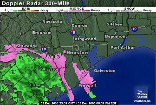
latest radar trends show the precip. weakening as it encounters the dry air in the area. However, I would not rule out a few snowflakes or sleet pellets continuing over parts of the area this evening.
It will be interesting to see if any more precipitation heads this way overnight or tomorrow morning. Tomorrow morning may be the most interesting though, because with temps. near freezing ANY precip. that is in the area will be of the frozen variety.
I doubt we will see much though. Most will have to wait until next time..
0 likes
-
Extremeweatherguy
- Category 5
- Posts: 11095
- Joined: Mon Oct 10, 2005 8:13 pm
- Location: Florida
Special Weather Statement
SPECIAL WEATHER STATEMENT
NATIONAL WEATHER SERVICE HOUSTON/GALVESTON TX
645 PM CST FRI DEC 8 2006
TXZ226-235>237-091200-
WHARTON-JACKSON-MATAGORDA-BRAZORIA-
INCLUDING THE CITIES OF...EL CAMPO...WHARTON...PIERCE...EDNA...
BAY CITY...PALACIOS...PEARLAND...LAKE JACKSON...ALVIN...
ANGLETON...FREEPORT
645 PM CST FRI DEC 8 2006
...LIGHT RAIN AND SLEET MIXED OR BRIEF PERIODS OF SLEET POSSIBLE
TONIGHT...
BRIEF PERIODS OF LIGHT RAIN MAY MIX WITH OR CHANGE OVER TO ALL
SLEET TONIGHT. NO ACCUMULATION IS EXPECTED. SINCE 5 PM...THERE
HAVE BEEN REPORTS OF BRIEF PERIODS OF SLEET IN WHARTON COUNTY.
HOWEVER...BECAUSE THE TEMPERATURE NEAR THE SURFACE WAS IN THE
LOWER 40S ACROSS THE FOUR COUNTY AREA...NO ACCUMULATION OF SLEET
HAS OCCURRED.
AFTER MIDNIGHT...LOW TEMPERATURES ARE EXPECTED TO FALL INTO THE
LOWER 30S. AS THE TEMPERATURE FALLS INTO THE 30S...ANY SLEET OR
LIGHT RAIN THAT FALLS MAY PRODUCE ICY CONDITIONS ON BRIDGES AND
OVERPASSES. OF THIS OCCURS...DRIVERS SHOULD PROCEED WITH CAUTION
IS ENCOUNTERING LIGHT RAIN OR SLEET.
LISTEN TO NOAA WEATHER RADIO OR YOUR LOCAL MEDIA FOR THE LATER
UPDATES ON THIS SITUATION.
0 likes
-
Opal storm
-
Extremeweatherguy
- Category 5
- Posts: 11095
- Joined: Mon Oct 10, 2005 8:13 pm
- Location: Florida
the western edge of the precip. shield looks to have a more northward movement to it. That is what I will be watching the most:
http://www.intellicast.com/IcastPage/Lo ... odnav=none
http://www.intellicast.com/IcastPage/Lo ... odnav=none
0 likes
-
Stratosphere747
- Category 5
- Posts: 3772
- Joined: Thu Sep 11, 2003 8:34 pm
- Location: Surfside Beach/Freeport Tx
- Contact:
At least Houston did update their disco....
http://www.srh.weather.gov/productview. ... =HGXAFDHGX
Off and on sleet here just outside of Angleton..
http://www.srh.weather.gov/productview. ... =HGXAFDHGX
Off and on sleet here just outside of Angleton..
0 likes
-
JenBayles

- Category 5
- Posts: 3461
- Age: 63
- Joined: Tue Aug 26, 2003 3:27 pm
- Location: Houston, TX
- Contact:
Just cold here in West Houston... and no fireplace! Well, I did cheat and turn on the starter, which looks rather nice with the glass doors and all, but... oh well. Better luck next time. 
Weatherrabbit - I was up in your neck of the woods today browsing through the junk/antique shops on the square. Lots of empty real estate from the last time I was through there several months ago. Whassup in Tomball anyway?!
Weatherrabbit - I was up in your neck of the woods today browsing through the junk/antique shops on the square. Lots of empty real estate from the last time I was through there several months ago. Whassup in Tomball anyway?!
0 likes
-
Extremeweatherguy
- Category 5
- Posts: 11095
- Joined: Mon Oct 10, 2005 8:13 pm
- Location: Florida
http://radar.weather.gov/radar.php?rid= ... 1&loop=yes
The batch of heavy precip. coming across Matagorda Bay right now looks interesting. It probably will be/is producing sleet and snow at a heavier rate. May be even some brief accumulations from this band?
The batch of heavy precip. coming across Matagorda Bay right now looks interesting. It probably will be/is producing sleet and snow at a heavier rate. May be even some brief accumulations from this band?
0 likes
-
Opal storm
Who is online
Users browsing this forum: Brent, Stratton23 and 119 guests