 The posts in this forum are NOT official forecast and should not be used as such. They are just the opinion of the poster and may or may not be backed by sound meteorological data. They are NOT endorsed by any professional institution or

If the guidance is right, the Arctic Oscillation is likely to remain predominantly positive to very positive through December after a brief decline.

For December as a whole, that’s not good news. Worse, if that news were not bad enough, there is a strong tendency for the Arctic Oscillation to remain predominantly positive in January following a highly positive figure in December. Through today, the Arctic Oscillation is averaging +2.360. If that average were to be maintained, it would be the highest December figure on record.
The 10 highest figures on record are:
Code: Select all
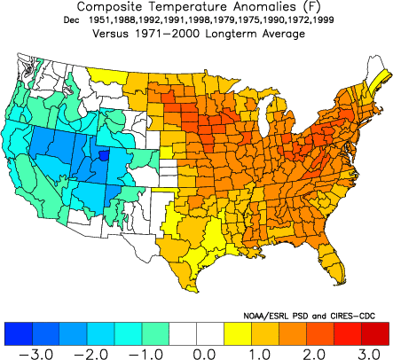
1951   1.987
1988   1.679
1992   1.627
1991   1.613
1998   1.353
1979   1.295
1975   1.290
1990   1.277
1972   1.238
1999   1.043
In 9/10 (90%) of the cases in which the Arctic Oscillation averaged +1.000 or above in December, January's figure was also > 0. The lone exception occurred in Winter 1979-80.
The outcomes in terms of composite temperature anomalies for the East are ugly.
December:
January:
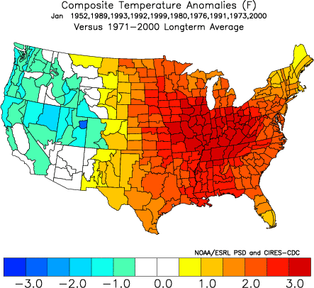
This outcomes would be quite consistent with what Joe Lundberg talked about in his column earlier today, specifically that the Euro monthly forecast for January was warm.
In terms of snowfall, such winters proved generally less snowy than average across much of the East. Median seasonal snowfall for select cities:
Boston: 23.5"
Buffalo: 80.7"
Burlington: 77.6"
Chicago: 39.6"
New York City: 14.6"
Philadelphia: 15.4"
Pittsburgh: 30.5"
Washington, DC (DCA): 9.2"
How December fares in terms of snowfall could provide a crucial indication as to how snowfall in the East will fare. Back in November, I provided the following select data:
Boston:
The indicators of below to much below normal seasonal snowfall following a November in which the mean temperature was 47° or above (November 2006: 49.1°) were:
∙ December snowfall of 5" or less
∙ December mean temperature of 36° or above
In such cases when December snowfall came to 5” or less, the mean seasonal snowfall was 17.9”. The most was 24.9”. In such cases when the mean December temperature came to 36° or above, the mean seasonal snowfall amounted to 20.9”. The most was 32.7”.
Current December snowfall: 0.4”
Mean December snowfall for the sample of strongly positive Arctic Oscillation years came to 5.4”. Moreover, 6/10 (60%) of those seasons had 5” or less snowfall in December. Through 12/15, December 2006 has a mean temperature of 41.7° in Boston. For Boston to finish with a mean temperature of < 36°, it would need to have a mean temperature of 30.6° for the remaining 16 days of the month. Model guidance suggests that this is not likely.
New York City:
The indicators of below to much below normal seasonal snowfall following a November with a mean temperature of 49.0° or above (November 2006: 51.9°) was less than 3” snowfall in December. In those seasons, the mean seasonal snowfall came to 13.1”. The median figure was 12.5”. The most was 30.6”.
Current December snowfall: None
Mean December snowfall for the sample of strongly positive Arctic Oscillation years came to 2.0”. Moreover, 7/10 (70%) of those seasons had less than 3” snowfall in December.
Washington, DC (DCA):
Indicators of below to much below normal seasonal snowfall following a November with a mean temperature of 48.0° to 52.0° (November 2006: 50.7°) were those in which December snowfall came to less than 6”. In those seasons, the mean seasonal snowfall came to 13.8”. The median figure was 13.0”. The most was 31.4”.
Current December snowfall: Trace
Mean December snowfall for the sample of strongly positive Arctic Oscillation years came to 1.1”. Moreover, 10/10 (100%) of those seasons had less than 6” snowfall in December.
The bottom line is that the December 23-31 pattern, which should provide cooler conditions in the East will need to see storminess coincide with the presence of sufficiently cold air to generate snow. There is still a realistic possibility that each of these cities might be able to receive enough snowfall to avoid falling into the very low snowfall category. Nonetheless, the risk of a very low snowfall winter is of growing concern.
For now, the idea of a return of meaningful blocking episodes as indicated by the historic experience with long-duration NAO+ regimes that began at the time the current one commenced, leaves the door open for colder weather especially later in January and February. Historic experience with El Niño events also lends some support to that idea. Therefore, I’m not yet ready to write off the idea of at least average snowfall, but I do believe December’s figures will be indicative of how things will turn out.
If, by some chance, that unhappy outcome of little or no December snowfall occurs and the Arctic Oscillation comes out with a stratospherically positive average for December, perhaps snow geese can urge their cities’ and towns’ governments to follow Lepe Spain's cue per a December 15, 2006 Associated Press report. Excerpts follow:
The last time it snowed in the sun-baked town of Lepe in southern Spain was in 1954. Now the stuff is falling every day — promptly at 8 p.m., for exactly 15 minutes — thanks to a mayor keen on concocting a white Christmas.
A pair of cannons blasting frozen precipitate over the town square have proven such a hit in Lepe — a town of 22,000 better known for its beaches and lush crops of strawberries — that human and traffic gridlock ensue every evening when it is time to snow.
"More than anything we are doing it for the younger people, who have never seen snow," Mayor Manuel Andres Gonzalez said last week, according to the newspaper El Pais.


