
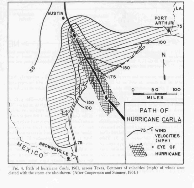
A tropical wave moves off the coast of Africa in late August of 1961. Perhaps, it was a large cluster of thunderstorms. We may never know. What matters is this tropical wave moves to the Caribbean. Conditions are favorable and becomes a tropical depression on September 3rd. Then it begins to strengthen into Tropical Storm Carla and becomes a hurricane. It moves between the Yuacatan Peninsula and Cuba and enters the Gulf of Mexico as a Category 2 hurricane with 105 mph winds. Once, it is over the Gulf, it rapidly intensify into a monsterous Category 5 hurricane. Carla's peak wind was 175 mph and central pressure of 936 millibars or less. Also, Carla is one of the largest Atlantic hurricanes on record with hurricane force winds extending at least 150 miles from the eye. Hurricane Carla heads towards the Texas Coast and it appears to make landfall on Galveston. However, a high pressure system push its further south. On September 11th, Carla makes landfall on Port O'Connor as a Category 4 hurricane with 145 mph winds and central pressure of 931 millibars. Gusts as high as 175 mph is recorded. All of the Texas coast is affected by Carla. 15 tp 20 foot storm surge plagues the Texas coast and rainfall as high as 19 inches is recorded in the Houston area. However, only 31 people died in Texas because many people had evacuated from the coast. A total of 43 people died from Carla. Once Carla makes landfall, it weakens into a tropical storm andends up in the Midwest as a prolific rainmaker. Hurricane Carla is one of the most intense hurricane to make landfall on America. Carla is also the largest hurricane to hit Texas.
Wikipedia-Hurricane Carla
Weather Underground-Hurricane Carla
NWS Corpus Christi-Hurricane Carla
Houston Chronicles-The lessons of Carla may be forgotten
Island of Galveston-Hurricane Carla
Hurricane Carla
Moderator: S2k Moderators
Forum rules

The posts in this forum are NOT official forecasts and should not be used as such. They are just the opinion of the poster and may or may not be backed by sound meteorological data. They are NOT endorsed by any professional institution or STORM2K. For official information, please refer to products from the National Hurricane Center and National Weather Service.
-
Derek Ortt
-
HurricaneBill
- Category 5

- Posts: 3420
- Joined: Sun Apr 11, 2004 5:51 pm
- Location: East Longmeadow, MA, USA
-
wxman57

- Moderator-Pro Met

- Posts: 23130
- Age: 68
- Joined: Sat Jun 21, 2003 8:06 pm
- Location: Houston, TX (southwest)
As you can see here, Karla's hurricane-force wind field was larger than Katrina's, Rita's, or Ivan's. Carla was one of the largest and most powerful hurricanes to make landfall on the U.S. coast. Had Carla hit the MS coast where Katrina and Camille did at the same size and intensity as when it hit the mid Texas coast, then the damage would have been FAR worse than either of those hurricanes. Oh, and I know Georges was just below Cat 3 strength in the NW Gulf. Close enough and it caused signifant damage.

0 likes

CrazyC83 wrote:Wow, Opal was a lot larger than I thought...and I thought Camille, Alicia and Andrew were more compact than that, like 25-35 miles wide?
Look at Bret - that is why it did so little damage for a Category 4 hurricane...it could have been stronger than Wilma and not been retired...
Weird part is Opal did not look all organized, even at her peak. Bret made landfall on King Rance in South Texas. That's why little damage was done. Also, due to its small size. The conditions could of allowed it to be like Wilma, but Bret interacted with land, so it weakend. Had it hit Brownsville or Corpus Christi, that would be bad. I am surprised Andrew was larger than I thought. I read Andrew was compact.
0 likes
-
HurricaneBill
- Category 5
- Posts: 3420
- Joined: Sun Apr 11, 2004 5:51 pm
- Location: East Longmeadow, MA, USA
HurricaneBill wrote:I think it was for Andrew's Louisiana landfall.
Now you mention it, I notice Andrew did get larger when it was in the Gulf of Mexico, before it mand landfall on Louisiana. I remember NHC saying it was a Category 4 with 140 mph winds and later revised it to 115 mph winds, which make it a Category 3.
0 likes
-
MGC

- S2K Supporter

- Posts: 5938
- Joined: Sun Mar 23, 2003 9:05 pm
- Location: Pass Christian MS, or what is left.
I doubt Camille had a nearly 50 NM radi of 65KT winds. At landfall, the extent of hurricane force winds likely extended from landfall in and about Waveland to about Biloxi Bay entrance. Keesler AFB, about 25 miles away from landfall in the right front quad only reported 81MPH sustainted winds. Camille's wind field was not as extensive as many believe.....MGC
0 likes
-
Derek Ortt
The winds near Pensacola were similar in Camille and Katrina. This suggests that the TS radii extended well away from the center.
This could be a Dennis type large storm or small core. However, if BAFB is not on the coast, that 81 sustained would be consistent with a major cane as the winds on the coast would have been in the cat 2 range, consistent with a cat 3-5 hitting to the west
This could be a Dennis type large storm or small core. However, if BAFB is not on the coast, that 81 sustained would be consistent with a major cane as the winds on the coast would have been in the cat 2 range, consistent with a cat 3-5 hitting to the west
0 likes
-
wxman57
- Moderator-Pro Met
- Posts: 23130
- Age: 68
- Joined: Sat Jun 21, 2003 8:06 pm
- Location: Houston, TX (southwest)
Ptarmigan wrote:Wxman57, interesting data about hurricane windfield size. Very eye opening. I wonder where you got those data? At the NHC site, they have advisories which include windfield, but it only goes back to 1998.
We found an advisory dataset that goes back to 1988 somewhere. What you see on the graphic is what we called and "effective radius" of 65kt winds. By that, I mean that we took the hurricane-force radius for each quadrant and calculated the circle diameter needed to give that radius. That gave us a way to compare the damage potential of these hurricanes in terms of areal coverage of hurricane-force winds. So, many of these hurricanes had more extensive wind fields right of the track, greater distances than indicated on the graphic.
Finally, the graphic represents the maximum size of the hurricane-force wind field IN the NW Gulf but not necessarily at landfall. We defined the NW Gulf as being north of 25N and west of 88W.
Oh, and one more thing. I was able to get SOME data for pre-1988 hurricanes. It's the data stored in the SLOSH model (.REX files). I'm not very sure of the reliability of these data, however.
0 likes
wxman57 wrote:
We found an advisory dataset that goes back to 1988 somewhere. What you see on the graphic is what we called and "effective radius" of 65kt winds. By that, I mean that we took the hurricane-force radius for each quadrant and calculated the circle diameter needed to give that radius. That gave us a way to compare the damage potential of these hurricanes in terms of areal coverage of hurricane-force winds. So, many of these hurricanes had more extensive wind fields right of the track, greater distances than indicated on the graphic.
Finally, the graphic represents the maximum size of the hurricane-force wind field IN the NW Gulf but not necessarily at landfall. We defined the NW Gulf as being north of 25N and west of 88W.
Oh, and one more thing. I was able to get SOME data for pre-1988 hurricanes. It's the data stored in the SLOSH model (.REX files). I'm not very sure of the reliability of these data, however.
Cool. Many hurricane data I've seen I do tend to question too, especially before 1970s. One thing to note is Carla having 175 mph winds and 936 millibars. That does not sound right because Carla was a large hurricane. My estimate is around 900 millibars or even less. There is also Hurricane Ethel of 1960, which is said to be a Category 5, but the pressure was 981 millibars. Either it was a really small hurricane because it hit the Gulf Coast as a tropical storm, which would be rapid weakening. Another possiblity is that it was measured incorrectly and standards back then were different then are today. Hurricane Gilbert on the other hand was quite large, but when it was in the Western Gulf, it had 950 millibars and winds of up to 135 mph.
0 likes
-
Derek Ortt
Carla almost certainly never had sustained winds anywhere near close to 175 mph
In the 1960s, nobody had any idea as to how flight level winds should be reduced. Often, 850mb winds were assumed to equal the surface winds.
The historical record in terms of wind speed before 1998 (back to about 1930), with the exception of Andrew and Donna which have been reanalyzed, is useless
In the 1960s, nobody had any idea as to how flight level winds should be reduced. Often, 850mb winds were assumed to equal the surface winds.
The historical record in terms of wind speed before 1998 (back to about 1930), with the exception of Andrew and Donna which have been reanalyzed, is useless
0 likes
Derek Ortt wrote:Carla almost certainly never had sustained winds anywhere near close to 175 mph
In the 1960s, nobody had any idea as to how flight level winds should be reduced. Often, 850mb winds were assumed to equal the surface winds.
The historical record in terms of wind speed before 1998 (back to about 1930), with the exception of Andrew and Donna which have been reanalyzed, is useless
From what I read Carla had sustained winds of 145 mph at landfall. Some say the 1886 Indianola Hurricane was a Category 5 at landfall. How do they do re-analysis for hurricanes?
0 likes
Who is online
Users browsing this forum: No registered users and 49 guests