The long season of mild weather which we have experienced through the winter has lately been succeeded by a plentiful fall of snow…
--The New Hampshire Gazette, March 19, 1819
That could well describe what I believe will be the likely turn of events as the calendar approaches and then moves into February. After an extremely slow start to Winter 2006-07 snowfall, with Albany picking up its latest first half-inch on record and New York City seeing its latest trace on record, a pattern that is more favorable to snowfall should be in place during the February 1-7 timeframe. All said, the combination of generally normal to colder-than-normal weather that is likely to prevail during the January 28-February 20 timeframe and an active subtropical jet is likely to result in this period receiving a disproportionate share of this winter’s seasonal snowfall across much of the East.
Some recent runs of the operational GFS have shown some support for greater storminess during the timeframe. At that range, the operational model’s details should not be taken at face value. The more general idea of possible storminess is a different matter, as it lends support larger evolution of the pattern.
At this time, taking into consideration the computer guidance coupled with a number of the GFS objective analogs centered around 1/30 and how the pattern is presently evolving, I believe there is a good chance that at least several of the big cities of the East Coast will see a moderate (4” or more) or significant (6” or more) snowfall during the above timeframe or no later than February 10.
My thinking for the average temperature anomalies during the 2/1-7 period is as follows:
Average Regional Temperature Anomalies (2/1-7):
Northeast: Below normal
Mid-Atlantic: Much below normal to below normal
Southeast: Below normal
Great Lakes: Below normal
Northern Plains: Somewhat below normal to near normal
Central Plains: Somewhat below normal
Southern Plains: Somewhat below normal
Pacific Northwest: Above normal
Southwest/Rest of West Coast: Above normal
For the major cities from Washington, DC to Boston, the 2/1-7 period is likely to feature:
- Nights generally in the teens and 20s.
- Days mainly in the 30s throughout the region.
- One or more days with a high temperature below 30° throughout the region.
In the Southeast, Atlanta will likely see highs generally in the upper 30s to lower 50s. Lows should generally be in the 20s and 30s. Burlington will likely see highs mainly in the teens and 20s. One or more subzero nights is possible.
The Next Pattern Change?
With a generally cold pattern in place, coupled with the potential for one or two strong outbreaks of cold and significant snowfall, the issue arises as to how long the pattern will last. An examination of pattern changes to colder that took place in the 1/5 through 1/25 timeframe since 1950 suggests that the current cold pattern should have a staying power of 3-4 weeks. The longest such cold patterns lasted just over 6 weeks. In those cases, extreme blocks developed and helped sustain the pattern. Of those colder patterns, 4 of the 6 that lasted 20-28 days saw a Kocin-Uccellini snowstorm. ENSO climatology also argues for at least a chance of a significant snowfall somewhere in the East during the winter.
For now, I believe the current cold pattern will continue through the above forecast period. A pattern change to milder could commence somewhere in the February 10-20 timeframe unless a strongly negative NAO develops. During the cold pattern, there is a good chance that the East Coast could experience a significant snowstorm. Hence, I have added confidence that the January 28-February 20 timeframe could provide a “snow rally” of sorts after a terrible start to the winter with respect to snowfall with the February 1-7 timeframe likely marking the beginning of this "snow rally."
February 1-7 2007 Idea: The Cold Continues
Moderator: S2k Moderators
Forum rules
 The posts in this forum are NOT official forecast and should not be used as such. They are just the opinion of the poster and may or may not be backed by sound meteorological data. They are NOT endorsed by any professional institution or STORM2K.

The posts in this forum are NOT official forecast and should not be used as such. They are just the opinion of the poster and may or may not be backed by sound meteorological data. They are NOT endorsed by any professional institution or STORM2K.
-
donsutherland1
- S2K Analyst

- Posts: 2718
- Joined: Mon Sep 15, 2003 8:49 pm
- Location: New York
-
Lowpressure

- S2K Supporter

- Posts: 2032
- Age: 59
- Joined: Sun Sep 14, 2003 9:17 am
- Location: Charlotte, North Carolina
Don, NWS Charlotte stating models are not handling the sw over the SW well at all. One run they eject a short wave, then poof, next run, staying in the SW. Temps here will be pretty good if one does eject, any thoughts on this? One run looks to have the Southern jet in charge, the next, northern.
0 likes
-
donsutherland1
- S2K Analyst
- Posts: 2718
- Joined: Mon Sep 15, 2003 8:49 pm
- Location: New York
During the week of December 6, 2006, the ENSO Region 3.4 anomaly peaked at +1.4°C. After holding at +1.0°C for the past two weeks, the anomaly dropped further to +0.6°C for the week of January 17, 2007.
In the past, once the Region 3.4 anomalies had decreased by +0.5°C from their peak during El Niño events in which the Region 3.4 anomalies peaked at +1.0°C to +2.0°C, the 30-day period beginning a week after the reported drop in the Region 3.4 anomalies often proved much snowier than the 30-day period immediately preceding the drop in the anomalies.
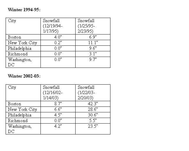
Unfortunately, sample size is extremely small. Weekly data only goes back to 1990. Since that time, two El Niño events meet the definition. Those occurred during Winters 1994-95 and 2002-03. Both winters saw the El Niño peak fairly close to that of the current El Niño event. Even more striking, both had faded by 0.5°C or more within days of the current El Niño event's having weakened by that amount.
Select Region 3.4 Anomalies:
Winter 1994-95:
Peak: +1.5°C, November 30, 1994
Had fallen by at least 0.5° from peak: January 18, 1995 (+1.0°C)
Winter 2002-03:
Peak: +1.8°C, November 20, 2002
Had fallen by at least 0.5° from peak: January 15, 2003 (+1.2°C)
30-Day Snowfall Amounts for Select Cities (1994-95 and 2002-03):
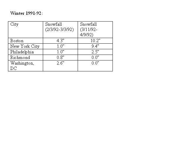
Given the small sample size, I examined another El Niño event that was just a little stronger than the threshold of the above two ENSO events: 1991-92.
Winter 1991-92:
Peak: +2.1°C, December 18, 1991
Had fallen by at least 0.5° from peak: March 4, 1992 (+1.6°C)
Even given how late in the season the El Niño had finally faded by +0.5°C or more, the northern Mid-Atlantic region (Philadelphia, New York City, and Boston) saw more snowfall in the March 11-April 9 timeframe than during the 30 day period that preceded the weakening in the El Niño.
30-Day Snowfall Amounts for Select Cities (1991-92):
All said, the latest weakening of the El Niño event gives me added confidence that the January 28-February 20 period could account for a disproportionate share of Winter 2006-07's seasonal snowfall. It also adds confidence that the February 1-7 timeframe should mark the beginning of the "snow rally."
In the past, once the Region 3.4 anomalies had decreased by +0.5°C from their peak during El Niño events in which the Region 3.4 anomalies peaked at +1.0°C to +2.0°C, the 30-day period beginning a week after the reported drop in the Region 3.4 anomalies often proved much snowier than the 30-day period immediately preceding the drop in the anomalies.
Unfortunately, sample size is extremely small. Weekly data only goes back to 1990. Since that time, two El Niño events meet the definition. Those occurred during Winters 1994-95 and 2002-03. Both winters saw the El Niño peak fairly close to that of the current El Niño event. Even more striking, both had faded by 0.5°C or more within days of the current El Niño event's having weakened by that amount.
Select Region 3.4 Anomalies:
Winter 1994-95:
Peak: +1.5°C, November 30, 1994
Had fallen by at least 0.5° from peak: January 18, 1995 (+1.0°C)
Winter 2002-03:
Peak: +1.8°C, November 20, 2002
Had fallen by at least 0.5° from peak: January 15, 2003 (+1.2°C)
30-Day Snowfall Amounts for Select Cities (1994-95 and 2002-03):
Given the small sample size, I examined another El Niño event that was just a little stronger than the threshold of the above two ENSO events: 1991-92.
Winter 1991-92:
Peak: +2.1°C, December 18, 1991
Had fallen by at least 0.5° from peak: March 4, 1992 (+1.6°C)
Even given how late in the season the El Niño had finally faded by +0.5°C or more, the northern Mid-Atlantic region (Philadelphia, New York City, and Boston) saw more snowfall in the March 11-April 9 timeframe than during the 30 day period that preceded the weakening in the El Niño.
30-Day Snowfall Amounts for Select Cities (1991-92):
All said, the latest weakening of the El Niño event gives me added confidence that the January 28-February 20 period could account for a disproportionate share of Winter 2006-07's seasonal snowfall. It also adds confidence that the February 1-7 timeframe should mark the beginning of the "snow rally."
0 likes

-
brunota2003

- S2K Supporter
- Posts: 9476
- Age: 35
- Joined: Sat Jul 30, 2005 9:56 pm
- Location: Stanton, KY...formerly Havelock, NC
- Contact:

I would like to thank all of you for your weather concerns and forecast. Don, I am an avid fan of your through all seasons but just a novelist in the weather department.
With all this talk about next week (first part of February) getting cold and some precip coming in - what is the outlook for North Carolina? I have some very important plans for February 2nd.
With all this talk about next week (first part of February) getting cold and some precip coming in - what is the outlook for North Carolina? I have some very important plans for February 2nd.
0 likes
-
southerngale

- Retired Staff

- Posts: 27418
- Joined: Thu Oct 10, 2002 1:27 am
- Location: Southeast Texas (Beaumont area)
-
Miss Mary
brunota2003 wrote:snowfall has been plentiful? what snowfall?oh yea...you mean that cold rainfall...yea, that has been plentiful...
brunota - you said it - "cold rainfall" - love it! Well, not really, hate it is more like it. But that certainly describes our winter (had a rare 3 inch snowfall the other day but that's been IT).
Maybe you've coined a new term....cold rainfall.
Mary
0 likes
-
donsutherland1
- S2K Analyst
- Posts: 2718
- Joined: Mon Sep 15, 2003 8:49 pm
- Location: New York
Hcaeb,
Thanks for the kind words.
With respect to 2/2, it would not suprise me if there were some ice/snow in parts of NC. A system should be passing near or through that region in the 2/1-3 timeframe. Some of the guidance, particularly the ensembles have been quite consistent with such an idea. It would also be consistent with what I feel will likely mark the beginning of a stormier pattern.
Things could still change given the timeframe involved.
Best wishes.
0 likes
-
donsutherland1
- S2K Analyst
- Posts: 2718
- Joined: Mon Sep 15, 2003 8:49 pm
- Location: New York
While many were worried by the big rise in temperatures forecast for 324 hours (2/6 12z) on the 1/24 0z run of the GFS or the storm that sailed harmlessly out to sea on the 1/24 6z run between 288-312 hours (2/5 6z-2/6 6z), several quick points are in order:
- The timing of the warmup was pushed from 2/6 12z on the 0z run to 2/8 6z on the 6z run.
- The ensembles have consistently been colder during the time in which the operational GFS has been forecasting a big warmup
Moreover, the 1/24 0z ensemble guidance provides a hint of a possible system that would track northeastward from the Southeastern U.S. before turning more east of north. This hint, more than the forecast precipitation amounts, is perhaps an early indication of a turn toward a stormier pattern I'm thinking will likely commence in the 2/1-7 timeframe. Moreover, it should be noted that most of the East is forecast to have 850 mb temperatures that would remain at or below normal during this event per the ensemble means.
312 hours:
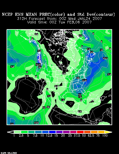
336 hours:

360 hours:

All said, my thinking for February 1-7 appears to be on track--at least for now.
- The timing of the warmup was pushed from 2/6 12z on the 0z run to 2/8 6z on the 6z run.
- The ensembles have consistently been colder during the time in which the operational GFS has been forecasting a big warmup
Moreover, the 1/24 0z ensemble guidance provides a hint of a possible system that would track northeastward from the Southeastern U.S. before turning more east of north. This hint, more than the forecast precipitation amounts, is perhaps an early indication of a turn toward a stormier pattern I'm thinking will likely commence in the 2/1-7 timeframe. Moreover, it should be noted that most of the East is forecast to have 850 mb temperatures that would remain at or below normal during this event per the ensemble means.
312 hours:
336 hours:
360 hours:
All said, my thinking for February 1-7 appears to be on track--at least for now.
0 likes

-
donsutherland1
- S2K Analyst
- Posts: 2718
- Joined: Mon Sep 15, 2003 8:49 pm
- Location: New York
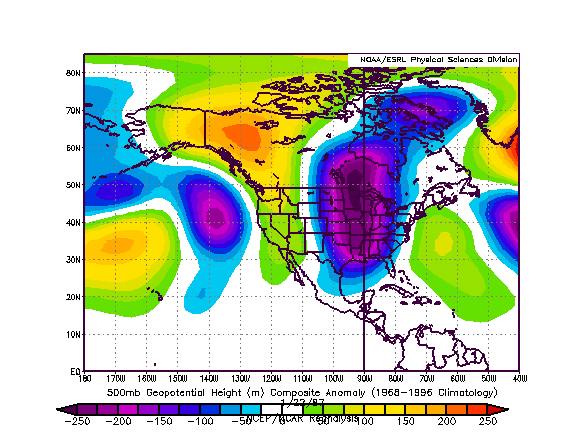
On an additional, my confidence in storminess coinciding with cold beginning in the 2/1-7 period is increasing. The look to the NCEP ensemble mean 500 mb anomalies at 216-240 hours is not all that different from the January 22-24, 1987 timeframe. It will be interesting to see if the details fall into place.
North America:
NCEP Ensemble Mean 500 Anomalies at 216 hours:

January 22, 1987 500 mb Anomalies
Northern Hemisphere:
NCEP Ensemble Mean 500 Anomalies at 216 hours:
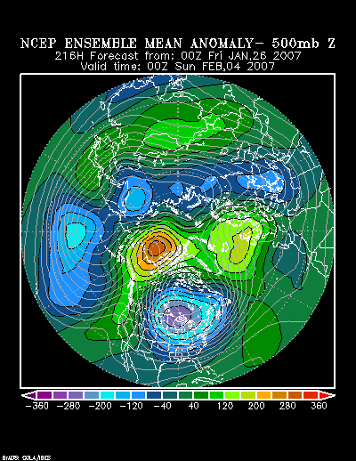
NCEP Ensemble Mean 500 Anomalies at 240 hours:
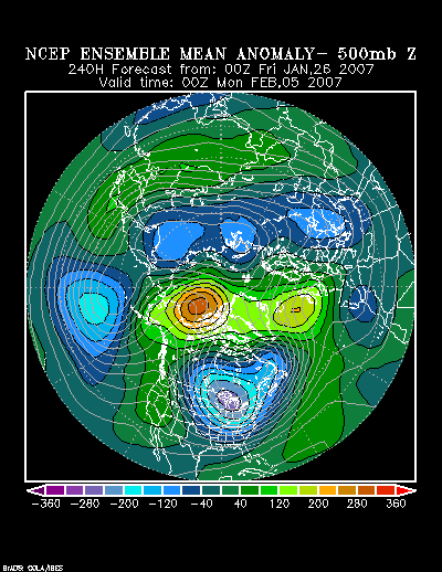
NCEP Ensemble Mean 500 Anomalies at 264 hours:

January 22, 1987 500 mb Anomalies:
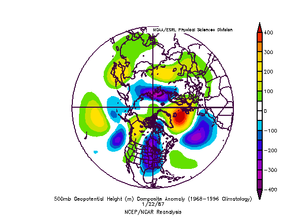
January 23, 1987 500 mb Anomalies:
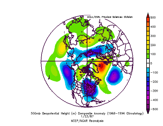
January 24, 1987 500 mb Anomalies:
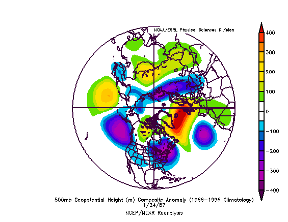
For now, at least for me, it's too soon to argue that there will, in fact, be such a storm. However, I think things are trending in the right direction for a return of storminess to coincide with the cold pattern now in place and it remains my thinking that there is a good chance that at least several of the big cities of the East Coast will see a moderate (4” or more) or significant (6” or more) snowfall during the February 1-7 timeframe or no later than February 10. Perhaps the periodic flirtation of the operational GFS (now you see a big storm, now you don't) might also be hinting of the possibility down the road.
Moreover, just as I believe such an event would be followed by another fresh outbreak of cold, the January 1987 event saw a very cold air mass in its wake. Temperatures fell into the single digits in Boston, New York City, Philadelphia, Washington, DC and Richmond even saw a radiational-cooling enhanced -1° low.
North America:
NCEP Ensemble Mean 500 Anomalies at 216 hours:
January 22, 1987 500 mb Anomalies
Northern Hemisphere:
NCEP Ensemble Mean 500 Anomalies at 216 hours:
NCEP Ensemble Mean 500 Anomalies at 240 hours:
NCEP Ensemble Mean 500 Anomalies at 264 hours:
January 22, 1987 500 mb Anomalies:
January 23, 1987 500 mb Anomalies:
January 24, 1987 500 mb Anomalies:
For now, at least for me, it's too soon to argue that there will, in fact, be such a storm. However, I think things are trending in the right direction for a return of storminess to coincide with the cold pattern now in place and it remains my thinking that there is a good chance that at least several of the big cities of the East Coast will see a moderate (4” or more) or significant (6” or more) snowfall during the February 1-7 timeframe or no later than February 10. Perhaps the periodic flirtation of the operational GFS (now you see a big storm, now you don't) might also be hinting of the possibility down the road.
Moreover, just as I believe such an event would be followed by another fresh outbreak of cold, the January 1987 event saw a very cold air mass in its wake. Temperatures fell into the single digits in Boston, New York City, Philadelphia, Washington, DC and Richmond even saw a radiational-cooling enhanced -1° low.
0 likes
NC Weather
Don,
Our weather person here in Raleigh loves the snow and ice season and he is still not mentioning any bad weather coming our way. Have your opinions changed since last posting. I have been watching the southern posts and the cold air is coming deep this time.
Your forecast is amazing for the north - hope you can help us in the Mid-Atlantic.
0 likes
Who is online
Users browsing this forum: No registered users and 123 guests