TX Winter Wx Threat # 10---cool/cold and wet?
Moderator: S2k Moderators
Forum rules
 The posts in this forum are NOT official forecast and should not be used as such. They are just the opinion of the poster and may or may not be backed by sound meteorological data. They are NOT endorsed by any professional institution or STORM2K.

The posts in this forum are NOT official forecast and should not be used as such. They are just the opinion of the poster and may or may not be backed by sound meteorological data. They are NOT endorsed by any professional institution or STORM2K.

As a general benchmark, February 15 is the deadline for the highest chances of very cold and wintry precip, as of course the south is where it begins to warm first. But of course there are extremes and perhaps we can experience such this year. Anyone recall 1968 when we in Baton Rouge and others in the south had measureable snow March 18 and again on March 19? Enough snow on the 18th to make a small snowman. The 19th we had school with periods of snow during the day, though the temps were probably just above freezing.
0 likes
-
srainhoutx

- S2K Supporter

- Posts: 6919
- Age: 68
- Joined: Sun Jan 14, 2007 11:34 am
- Location: Haywood County, NC
- Contact:
Interesting ADF from Houston WFO regarding next weekend...
FXUS64 KHGX 042104
AFDHGX
AREA FORECAST DISCUSSION
NATIONAL WEATHER SERVICE HOUSTON/GALVESTON TX
304 PM CST SUN FEB 4 2007
.DISCUSSION...HIGH CLOUDS CONTINUE TO LINGER ACROSS THE COASTAL
SECTIONS OF SOUTHEAST TEXAS THIS AFTERNOON. IN ADDITION...SOME
LOWER CLOUDS HAVE DEVELOPED ACROSS SOUTHWEST PORTIONS OF THE CWA.
COLD FRONT ACROSS NORTH TX SHOULD REMAIN NORTH OF THE CWA TONIGHT
AS THE HIGH PRESSURE RIDGE ACROSS THE NORTHERN PLAINS BUILDS
FARTHER EAST THAN SOUTH THROUGH MONDAY. THIS WILL CONTINUE TO
PROVIDE A WEAK PRESSURE GRADIENT ACROSS EAST TX AND NORTHWEST FLOW
ALOFT WILL CONTINUE TO PROVIDE SUBSIDENCE THROUGH TUESDAY.
TEMPERATURES ARE EXPECTED TO WARM THE NEXT COUPLE OF DAYS
ESPECIALLY TUESDAY AS MORE OF A SOUTH WIND DEVELOPS WITH LOW
PRESSURE ACROSS THE CENTRAL UNITED STATES. 500MB RIDGE ACROSS THE
WESTERN U.S. WILL EVENTUALLY FLATTEN OUT WEDNESDAY AS A WEAK
SHORTWAVE TROUGH DEVELOPS ACROSS WEST TX. THIS WILL ALLOW LOW TO
MID LEVEL MOISTURE TO INCREASE WED NIGHT INTO THURSDAY AS A COLD
FRONT MOVES SOUTHWARD ACROSS NORTHEAST TX INTO SOUTHEAST TX. WILL
KEEP A SLIGHT CHANCE OF SHOWERS THURSDAY INTO FRIDAY AS THE HIGH
PRESSURE RIDGE BEHIND THE FRONT WILL BUILD MORE EASTWARD THAN
SOUTHWARD ALLOWING THE FRONTAL BOUNDARY TO LINGER ACROSS THE
WESTERN GULF OF MEXICO. COLDER AIR WILL HOWEVER FILTER INTO
SOUTHEAST TX THURSDAY INTO FRIDAY WITH THE BULK OF THE CANADIAN
AIRMASS COMING SOUTHWARD SATURDAY. OVERRUNNING CONDITIONS ARE
PROGGED TO DEVELOP WITH RAIN CHANCES INCREASING SAT NIGHT AS LOW
TO MID LEVEL MOISTURE CONTINUES TO INCREASE. LIGHT STRATIFORM
PRECIPITATION WILL LIKELY LINGER INTO SUNDAY AS MOISTURE CONTINUES
TO POOL ACROSS THE WESTERN GULF OF MEXICO.
0 likes
-
srainhoutx
- S2K Supporter
- Posts: 6919
- Age: 68
- Joined: Sun Jan 14, 2007 11:34 am
- Location: Haywood County, NC
- Contact:
Austin/San Antonio WFO's take on the next event...
FXUS64 KEWX 042112
AFDEWX
AREA FORECAST DISCUSSION
NATIONAL WEATHER SERVICE AUSTIN/SAN ANTONIO TX
312 PM CST SUN FEB 4 2007
.DISCUSSION...
A WARMING TREND HAS BEGUN...WITH THE PACIFIC MOISTURE PLUME
SHIFTING OFF TO THE EAST AND WEAK RIDGING ALOFT. NEAR NORMAL TEMPS
TODAY WILL BE REPLACED WITH ABOVE NORMAL TEMPS MONDAY AND TREND TO
WELL ABOVE NORMAL BY WEDNESDAY. FOG IS FORECAST LATE
TONIGHT...THEN AGAIN MONDAY NIGHT AND TUESDAY NIGHT AS LOW LEVEL
MOISTURE GRADUALLY INCREASES ACROSS OUR AREA AND A FAVORABLE
ATMOSPHERIC MOISTURE PROFILES DEVELOPS.
THE ARCTIC COLD FRONT FORECAST TO PUSH THROUGH LATE FRIDAY IS NOW
FORECAST TO PUSH THROUGH EARLY THURSDAY...WITH MODERATE TO HIGH
CONFIDENCE GIVEN THE 12Z ECMWF AND GFS SOLUTIONS AT 96H. THE 1ST
SHOT WILL BE COLD...BUT THE 2ND SHOT ON SATURDAY WILL BE COLDER.
CLOUDS AND POSSIBLY RAIN BEHIND THE FRONT ARE A LOWER CONFIDENCE
FORECAST...AS THE UPPER FLOW BECOMES SLIGHTLY NORTH OF WEST WHICH
WOULD GENERALLY BE DRY.
OUR NUMBERS FOR MAX/MIN TEMPS ARE CLOSE TO 12Z GFS MOS THROUGH
WEDNESDAY NIGHT...THEN 1 TO 9 DEGREES BELOW THEREAFTER IN A CRUDE
ATTEMPT TO REMOVE THE CLIMO INFLUENCE IN THE MOS EQUATIONS WITH AN
UNUSUALLY COLD AIRMASS EXPECTED. THERE IS SOME POTENTIAL FOR
OBSERVED TEMPS TO BE A GOOD 5 TO 10 DEGREES BELOW OUR
FORECAST...ESPECIALLY NEXT WEEKEND...BUT WILL NEED MORE RUN-TO-RUN
CONSISTENCY BEFORE STRAYING TOO FAR.
0 likes
-
Extremeweatherguy

- Category 5

- Posts: 11095
- Joined: Mon Oct 10, 2005 8:13 pm
- Location: Florida
With more cold air to work with to our north, next weekend will probably end up being colder than this Fri/Sat was (especially for high temperatures since there will be more cloud cover/precip). Could get interesting for sure..
On the bright side though, this week should be nice out ahead of the chill. Highs may even be pushing 70 on Wednesday!
On the bright side though, this week should be nice out ahead of the chill. Highs may even be pushing 70 on Wednesday!
0 likes
-
Extremeweatherguy
- Category 5
- Posts: 11095
- Joined: Mon Oct 10, 2005 8:13 pm
- Location: Florida
This time, instead of speculating on whether or not the local media and NWS will be right/wrong, I will just simply post both of their current forecasts and then wait to comment on them until later...
CHAN. 2:
(static image)
NWS:
These should be fun to look back on this weekend and see how right or wrong they end up being when it is all said and done.
CHAN. 2:
(static image)
NWS:
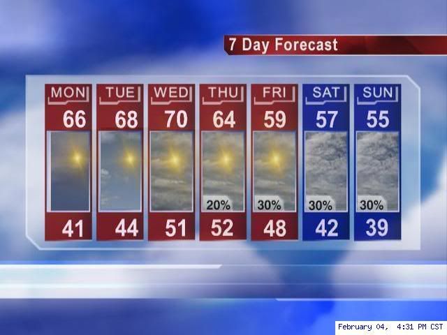
Thursday: A 20 percent chance of showers. Mostly cloudy, with a high near 61.
Thursday Night: A 20 percent chance of showers. Partly cloudy, with a low around 45.
Friday: A 20 percent chance of showers. Partly cloudy, with a high near 58.
Friday Night: A 20 percent chance of showers. Mostly cloudy, with a low around 44.
Saturday: A 20 percent chance of rain. Mostly cloudy, with a high near 54.
Saturday Night: A 30 percent chance of rain. Cloudy, with a low around 38.
Sunday: A 20 percent chance of rain. Cloudy, with a high near 52.
These should be fun to look back on this weekend and see how right or wrong they end up being when it is all said and done.
0 likes
-
Portastorm

- Storm2k Moderator

- Posts: 9954
- Age: 63
- Joined: Fri Jul 11, 2003 9:16 am
- Location: Round Rock, TX
- Contact:
-
Extremeweatherguy
- Category 5
- Posts: 11095
- Joined: Mon Oct 10, 2005 8:13 pm
- Location: Florida
Oh, and I completely agree..at the moment I think those are reasobale forecasts. However, as we have seen in the past..things change quickly, so it should be interesting to see how these early forecasts line up with what actually happens. One thing I have noticed though is that in overrunning situations, the initial forecasts are usually too warm.Portastorm wrote:EWG, I think from what the models are showing right now ... these forecasts are reasonable. Don't see why I would budge much for SE Tx with these numbers.
There's plenty of time to adjust either up or down depending on the trend.
0 likes

Portastorm wrote:double D wrote:cheezyWXguy wrote:double D wrote:I'm starting to think that next weekend will end up just cool not cold. Looking at the models this morning, it still appears that the high slides off to the east and Texas gets a glancing blow once again. It might feel a little cooler due to overrunning rains, but the brunt of the cold appears to hit the east and southeast US.
I don't think February will be our month for extreme cold.
I have no idea how u can randomly make a decision about the entire month of February based on this weekend...besides its still 7 days away...nothings written in stone...lets just wait and see...i think well have a chance, but who knows
Well considering that this weekend will be the 10th and 11th of Feb., our time for cold is running out. Most of our arctic outbreaks come from western Canada, and all the very cold air is in central and eastern Canada. The time it takes for the arctic air to build back up, we will be into the latter part of February and it's very rare for Texas to have extreme cold that late in February. If you live in Dallas, then your chances of cold are a little better than for us in central and southeast Texas. Also, there were a couple of pro mets from various sources forecasting VERY COLD historic outbreaks for Texas, and that's what I meant by " I don't think February will be our month for extreme cold".
Don't disagree with you double D ... but I do want to remind you that the last winter we saw a waning El Nino (2003), we had quite a major winter weather event here in central Texas during late February ... 2 days of sleet, snow, and ice. Not saying that will happen ... but it's not unprecedented. No denying though that time is quickly running out.
Very good point Portastorm, it would be nice to see one more winter weather event before we enter into spring. Does anybody remember how hot February was in 1996? I was living in San Antonio at the time and it reached 100 degrees during that month, now that is what I call a heat wave.
0 likes
-
Portastorm
- Storm2k Moderator
- Posts: 9954
- Age: 63
- Joined: Fri Jul 11, 2003 9:16 am
- Location: Round Rock, TX
- Contact:
Johnny wrote:I hope y'all aren't thinking that we will be having a major cold blast coming through next weekend. If we have overrunning after the frontal passage, I'm thinking we will get stuck in the 40's and that's it.
AFM will be in here shortly to bring everyone back to reality.
Now Johnny ... none of us have said that next weekend would definitely be a "cold blast." All we are bringing up is that several computer models (12z GFS and Canadian) suggest as much as do National Weather Service forecasters (which has been documented by the posts).
AFM has already gone on record as saying the bulk of the cold air and the high would slide to our northeast next weekend and ... right now ... the majority of computer models support his thought.
0 likes
-
Extremeweatherguy
- Category 5
- Posts: 11095
- Joined: Mon Oct 10, 2005 8:13 pm
- Location: Florida
yeah, we will probably be stuck in the 40s for highs..may be a day or two in the 30s if everything were to play out right (remember late last Feb?), but I don't think we are looking at a record-smashing cold snap or anything; probably just a 3-4 day stretch of cold, cloudy weather.Johnny wrote:I hope y'all aren't thinking that we will be having a major cold blast coming through next weekend. If we have overrunning after the frontal passage, I'm thinking we will get stuck in the 40's and that's it.
AFM will be in here shortly to bring everyone back to reality.
0 likes
-
Portastorm
- Storm2k Moderator
- Posts: 9954
- Age: 63
- Joined: Fri Jul 11, 2003 9:16 am
- Location: Round Rock, TX
- Contact:
Portastorm wrote:Johnny wrote:I hope y'all aren't thinking that we will be having a major cold blast coming through next weekend. If we have overrunning after the frontal passage, I'm thinking we will get stuck in the 40's and that's it.
AFM will be in here shortly to bring everyone back to reality.
Now Johnny ... none of us have said that next weekend would definitely be a "cold blast." All we are bringing up is that several computer models (12z GFS and Canadian) suggest as much as do National Weather Service forecasters (which has been documented by the posts).
AFM has already gone on record as saying the bulk of the cold air and the high would slide to our northeast next weekend and ... right now ... the majority of computer models support his thought.
A quick, early perusal of the 0z and 6z GFS as well as the 0z Euro show the high late this week sliding to our northeast and barely impacting Texas. So there you go ...
0 likes
-
jasons2k

- Storm2k Executive

- Posts: 8290
- Age: 52
- Joined: Wed Jul 06, 2005 12:32 pm
- Location: The Woodlands, TX
I think there is a decent shot Houston has seen its last freeze of the season. Most of the cold air has been tapped, this weekend's front doesn't look like it will threaten a freeze, and as some have pointed out we are running out of time. I don't see anything building on the horizon that would threaten us.
0 likes

Bring on Spring!!!!!!!!
I am done with Winter.
I am done with Winter.
0 likes
The following post is NOT an official forecast and should not be used as such. It is just the opinion of the poster and may or may not be backed by sound meteorological data. It is NOT endorsed by any professional institution including storm2k.org For Official Information please refer to the NHC and NWS products.
-
vbhoutex

- Storm2k Executive
- Posts: 29143
- Age: 74
- Joined: Wed Oct 09, 2002 11:31 pm
- Location: Cypress, TX
- Contact:
I am hoping Winter is over too. But, I've seen snow in Houston on the 16th of February before and freezing temps well into March.
As stated though, it appears that the cold areas that would normally affect us here in TX have been pretty well tapped unless there is some unexpected recharge coming across the poles that no one has seen yet. It always "bears" watching.
As stated though, it appears that the cold areas that would normally affect us here in TX have been pretty well tapped unless there is some unexpected recharge coming across the poles that no one has seen yet. It always "bears" watching.
0 likes
-
southerngale

- Retired Staff

- Posts: 27418
- Joined: Thu Oct 10, 2002 1:27 am
- Location: Southeast Texas (Beaumont area)

-
jasons2k
- Storm2k Executive
- Posts: 8290
- Age: 52
- Joined: Wed Jul 06, 2005 12:32 pm
- Location: The Woodlands, TX
Hey Southerngale, I'm right there with you!! I have a trickle of water draining into my curb and I thought it was a leak. About two months ago I turned off my sprinkler system to give my lawn a chance to dry out and see for sure if it was a leak or just a perpetually wet yard. Two months later my lawn STILL hasn't dried out enough to see, as it has rained almost every day. Last night I was venting this to my wife and she said just shot off the weter main and see if the meter still runs - duh!! I knew that already but she had to remind me - haha.
Oh, and they are building a new shopping center very close to my house. They are probably a good 6-weeks behind and all the heavy equipment looks like it is stuck in quicksand. There is standing water everywhere - and it's starting to stink!! It smells like a mixture of stale water and rotting pine mulch! Yuck! C'mom sun!!!
Oh, and they are building a new shopping center very close to my house. They are probably a good 6-weeks behind and all the heavy equipment looks like it is stuck in quicksand. There is standing water everywhere - and it's starting to stink!! It smells like a mixture of stale water and rotting pine mulch! Yuck! C'mom sun!!!
0 likes
-
Portastorm
- Storm2k Moderator
- Posts: 9954
- Age: 63
- Joined: Fri Jul 11, 2003 9:16 am
- Location: Round Rock, TX
- Contact:
-
cctxhurricanewatcher

- Category 5
- Posts: 1206
- Joined: Sun Sep 12, 2004 8:53 pm
- Location: Corpus Christi, Texas
jschlitz wrote:Hey Southerngale, I'm right there with you!! I have a trickle of water draining into my curb and I thought it was a leak. About two months ago I turned off my sprinkler system to give my lawn a chance to dry out and see for sure if it was a leak or just a perpetually wet yard. Two months later my lawn STILL hasn't dried out enough to see, as it has rained almost every day. Last night I was venting this to my wife and she said just shot off the weter main and see if the meter still runs - duh!! I knew that already but she had to remind me - haha.
Oh, and they are building a new shopping center very close to my house. They are probably a good 6-weeks behind and all the heavy equipment looks like it is stuck in quicksand. There is standing water everywhere - and it's starting to stink!! It smells like a mixture of stale water and rotting pine mulch! Yuck! C'mom sun!!!
Same here with the yard thing. I haven't turned on the sprinkler system since early December which is fine as far as the water bill thing. But it would be nice to start drying out. I know the Farmers down here are wanting dry weather now so they can start planting. The Ranchers are happy because their pastrures are going to be almost Ireland green when the grass starts growing again in a few weeks.
All of this moisture is going to do wonders for most of them come harvest or auction time (cattle) after two or three years of horrible droughts during the winter and spring months down here.
0 likes
Who is online
Users browsing this forum: No registered users and 70 guests