My snow, where are you?
I’ve been waiting…
These storms, they just keep passing through…
—Adapted from Naomi Striemer’s “Cars”
For residents in the snow-starved big cities of the Middle Atlantic and southern New England region, that question could be asked with increasing urgency as the calendar advances into March. Even as colder weather returns to the East, it will likely do so in the wake of systems that seem to keep passing to the north and west of the I-95 cities. Yet, even as the East watches as the storms traverse a track through the Ohio Valley and Great Lakes region, the Northern Plains should experience a vigorous recovery from depressed seasonal snowfall totals. Severe weather is possible in the warm sector of such systems.
The upcoming pattern will likely feature a noted absence of a strong NAO block. The EPO is likely to average > 0, as well. However, there remains considerable uncertainty in terms of overall anomalies. The GFS ensembles favor a cool start to the month in the East. That idea receives support from 2/19 0z ECMWF’s 240-hour forecast of the 500 mb pattern. The ECM objective analogs are warm in the Northeast and very cold in the Central and Northern Plains. The GSM is very warm in the East. Given the recent poor performance with both the objective analogs and the GSM, I’ll place greater weight on the GFS ensembles.
As for March, as a whole, I believe the Northern Plains and northern New England could average 1°-2° below normal. The Southeast and Southern Plains could average around 1°-3° above normal. The Pacific Northwest could average about 1° below normal. The remainder of the nation should be near to somewhat above normal.
My thinking for the average temperature anomalies during the 3/1-7 period is as follows:
Average Regional Temperature Anomalies (3/1-7):
Northeast: Somewhat below normal
Mid-Atlantic: Below normal
Southeast: Below normal
Great Lakes: Below normal
Northern Plains: Somewhat below normal to near normal
Central Plains: Somewhat below normal to near normal
Southern Plains: Near normal
Pacific Northwest: Near normal to somewhat above normal
Southwest/Rest of West Coast: Above normal
For the major cities from Washington, DC to Boston, the 3/1-7 period is likely to feature:
- Nights generally in the 20s and 30s in Boston, and 30s in New York City, Philadelphia, and Washington, DC.
- Days mainly in the 30s and 40s in Boston, 40s in New York City and Philadelphia, and 40s with a few 50s in Washington, DC.
- One or two days with a low temperature in the teens in Boston, and 20s in New York City, Philadelphia, and Washington, DC.
In the Southeast, Atlanta will likely see highs generally in the 50s with some 60s possible. Lows should generally be in the 30s and 40s. Elsewhere, Burlington will likely see highs mainly in the 20s and 30s. Lows should be in teens. A single-digit low is possible on one or two days.
March 1-7, 2007 Idea: March Starts Chilly in the East
Moderator: S2k Moderators
Forum rules
 The posts in this forum are NOT official forecast and should not be used as such. They are just the opinion of the poster and may or may not be backed by sound meteorological data. They are NOT endorsed by any professional institution or STORM2K.

The posts in this forum are NOT official forecast and should not be used as such. They are just the opinion of the poster and may or may not be backed by sound meteorological data. They are NOT endorsed by any professional institution or STORM2K.
-
donsutherland1
- S2K Analyst

- Posts: 2718
- Joined: Mon Sep 15, 2003 8:49 pm
- Location: New York
-
Tstormwatcher

- S2K Supporter

- Posts: 3086
- Joined: Thu Oct 20, 2005 7:31 pm
- Location: New Bern, NC

-
donsutherland1
- S2K Analyst
- Posts: 2718
- Joined: Mon Sep 15, 2003 8:49 pm
- Location: New York
Re: March 1-7, 2007 Idea: March Starts Chilly in the East
In spite of the cool start that I expect for the 3/1-7 timeframe (average anomalies) for much of the East/Great Lakes region, I also noted:
As for March, as a whole, I believe the Northern Plains and northern New England could average 1°-2° below normal. The Southeast and Southern Plains could average around 1°-3° above normal. The Pacific Northwest could average about 1° below normal. The remainder of the nation should be near to somewhat above normal.
The likely transition of the Arctic Oscillation to positive by 2/24-27 may also be providing a signal of a change--perhaps dramatic--to warmer sometime in the 3/10-20 timeframe. Since 1950, there have been 8 occasions in which the AO went negative in the 1/15-2/15 timeframe and then remained negative for a medium duration (20-30 days). In 5/8 (63%) cases, the NAO tanked, usually just prior to the AO flipping to positive. In this case, the ensemble guidance is strongly against such a proposition.
That leaves 3 cases in which the NAO did not tank prior to the AO's flip to positive: 1974, 1983, and 2006. In all three cases, there was a period of above to much above normal readings in the East after the AO went positive. Of the three cases, 1974 has the best fit when both the NAO and PNA are taken into consideration.
With respect to climatology, since 1950, one has seen 3 cases in which March had an NAO that averaged in the +0.000 to +3.000 range and the PNA averaged < 0. I use those figures only because that is the extent to which the ensemble forecast for these teleconnection indices goes out. The 500 mb anomalies for such a situation are as follows:
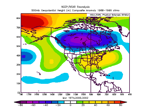
The question then arises as to whether things will trend in that direction. I compare both the NCEP 500 mb mean anomaly forecast and the 500 mb anomalies for 1974.
NCEP Ensemble 500 Mb Anomalies (264 hours):
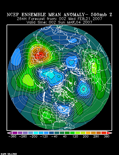
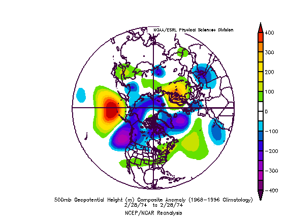
February 23, 1974:
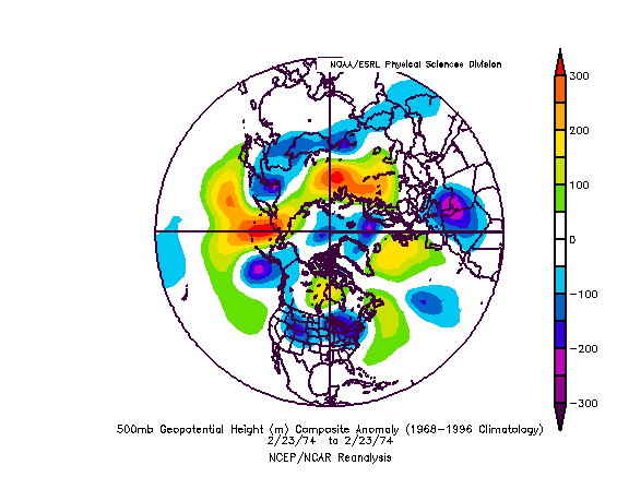
NCEP Ensemble 500 mb Anomalies (360 hours):[b/]
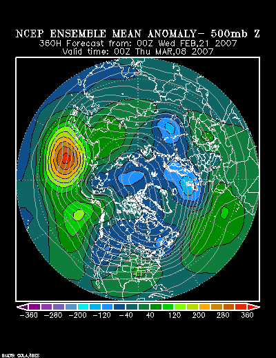
[b]February 28, 1974:
Shortly thereafter, a persistent tendency for ridging in the East developed. At that time, approximately 8-10 days after the AO had gone positive, warm anomalies were widespread in the eastern United States. If one used the 2/24-27 timeframe, 8-10 days later would bring the calendar to 3/4-3/9 for the warmth to begin to appear in the East. Given the pattern evolution, I'm expecting, I believe the warmth will begin to manifest itself after the first week in March.
Continuing with 1974, here are the anomalies by 3/7:
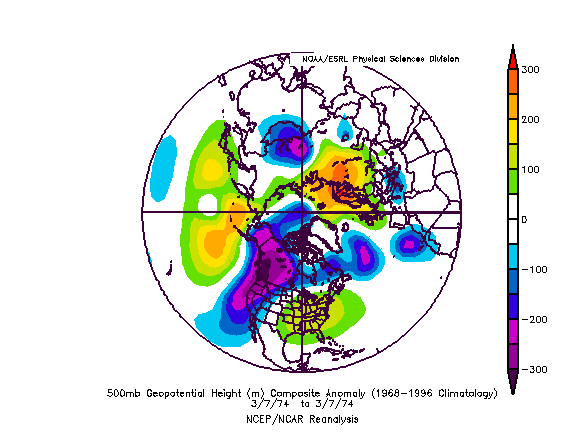
The huge ridge over the Southeastern U.S. is consistent with the 500 mb anomalies associated with a modestly positive NAO/negative PNA. Even by 360 hours on the NCEP ensemble mean anomalies, one sees perhaps the first indications of an incipient ridge in the Southeast.
All said, I believe that once the 3/1-7 period passes, odds probably favor a trend toward greater warmth in the East. Whether or not that trend will be delayed remains to be seen. For now, that's not yet a forecast, but it is something to look out for.
As for March, as a whole, I believe the Northern Plains and northern New England could average 1°-2° below normal. The Southeast and Southern Plains could average around 1°-3° above normal. The Pacific Northwest could average about 1° below normal. The remainder of the nation should be near to somewhat above normal.
The likely transition of the Arctic Oscillation to positive by 2/24-27 may also be providing a signal of a change--perhaps dramatic--to warmer sometime in the 3/10-20 timeframe. Since 1950, there have been 8 occasions in which the AO went negative in the 1/15-2/15 timeframe and then remained negative for a medium duration (20-30 days). In 5/8 (63%) cases, the NAO tanked, usually just prior to the AO flipping to positive. In this case, the ensemble guidance is strongly against such a proposition.
That leaves 3 cases in which the NAO did not tank prior to the AO's flip to positive: 1974, 1983, and 2006. In all three cases, there was a period of above to much above normal readings in the East after the AO went positive. Of the three cases, 1974 has the best fit when both the NAO and PNA are taken into consideration.
With respect to climatology, since 1950, one has seen 3 cases in which March had an NAO that averaged in the +0.000 to +3.000 range and the PNA averaged < 0. I use those figures only because that is the extent to which the ensemble forecast for these teleconnection indices goes out. The 500 mb anomalies for such a situation are as follows:
The question then arises as to whether things will trend in that direction. I compare both the NCEP 500 mb mean anomaly forecast and the 500 mb anomalies for 1974.
NCEP Ensemble 500 Mb Anomalies (264 hours):
February 23, 1974:
NCEP Ensemble 500 mb Anomalies (360 hours):[b/]
[b]February 28, 1974:
Shortly thereafter, a persistent tendency for ridging in the East developed. At that time, approximately 8-10 days after the AO had gone positive, warm anomalies were widespread in the eastern United States. If one used the 2/24-27 timeframe, 8-10 days later would bring the calendar to 3/4-3/9 for the warmth to begin to appear in the East. Given the pattern evolution, I'm expecting, I believe the warmth will begin to manifest itself after the first week in March.
Continuing with 1974, here are the anomalies by 3/7:
The huge ridge over the Southeastern U.S. is consistent with the 500 mb anomalies associated with a modestly positive NAO/negative PNA. Even by 360 hours on the NCEP ensemble mean anomalies, one sees perhaps the first indications of an incipient ridge in the Southeast.
All said, I believe that once the 3/1-7 period passes, odds probably favor a trend toward greater warmth in the East. Whether or not that trend will be delayed remains to be seen. For now, that's not yet a forecast, but it is something to look out for.
0 likes
-
Category 5

- Category 5

- Posts: 10074
- Age: 36
- Joined: Sun Feb 11, 2007 10:00 pm
- Location: New Brunswick, NJ
- Contact:
-
NC George

- Category 2

- Posts: 635
- Age: 56
- Joined: Sun Sep 14, 2003 11:44 am
- Location: Washington, NC, USA
Tstormwatcher wrote:As the days pass by, it looks more and more like there will be no snow for us in eastern NC for a second year in a row.
What, it snowed here in eastern NC earlier this year. We had 1" on the grond for about 6 hours! Then the rain started and it all went away. This was in Ayden, just 30 miles or so NW of you.
0 likes
-
donsutherland1
- S2K Analyst
- Posts: 2718
- Joined: Mon Sep 15, 2003 8:49 pm
- Location: New York
-
donsutherland1
- S2K Analyst
- Posts: 2718
- Joined: Mon Sep 15, 2003 8:49 pm
- Location: New York
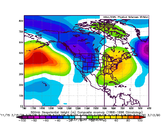
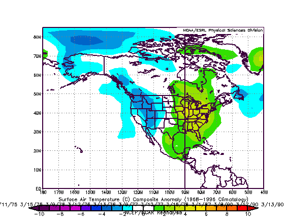
Adding to last night's discussion of where things might evolve beginning in the 3/10-20 timeframe, I examined composite 500 mb height and surface temperature anomalies for the 1971-2000 timeframe during which the NAO was 0.000 to +0.500 and the PNA was -3.000 to 0.000. I used the 3/1-15 timeframe, as such a situation is showing up in the extended guidance toward the end of that timeframe. Consistent with the monthly maps that I posted last night, there was a tendency for ridging/warmth in the East.
500 mb Anomalies:
Temperature Anomalies:
Following the demise of the medium-duration AO- regime in 1974, during which no strongly negative NAO developed, the situation evolved to the following 500 mb pattern on March 7:
That upper air pattern bears a striking similarity to the composite 500 mb height anomalies posted above.
In short, I believe odds probably favor a turn to a warmer pattern beginning sometime in the 3/10-20 timeframe. Before that pattern breaks, it could bring with it some much above normal readings in the East. However, prior to such a pattern taking hold, there is some chance that the large area of exceptional cold that is modeled for western Canada might try to enter to the CONUS. There is also a chance that this area of cold just sweeps across Canada and only brushes the northern part of the U.S. (Northern Plains, northern Great Lakes region, northern New England) after impacting the Pacific Northwest. Hopefully, by the time I post my March 8-15 thoughts sometime next week, I'll have a better idea as to how things will evolve.
0 likes
-
Tstormwatcher
- S2K Supporter
- Posts: 3086
- Joined: Thu Oct 20, 2005 7:31 pm
- Location: New Bern, NC
NC George wrote:Tstormwatcher wrote:As the days pass by, it looks more and more like there will be no snow for us in eastern NC for a second year in a row.
What, it snowed here in eastern NC earlier this year. We had 1" on the grond for about 6 hours! Then the rain started and it all went away. This was in Ayden, just 30 miles or so NW of you.
Didn't get a flake where I live.
0 likes
-
Category 5
- Category 5
- Posts: 10074
- Age: 36
- Joined: Sun Feb 11, 2007 10:00 pm
- Location: New Brunswick, NJ
- Contact:
Stephanie wrote:I think that winter is now beginning to fade. I'm sure we'll still get some cold snaps and perhaps some more snow showers but I think she's winding up.
We usually do. Remember last april, that morning it was 45 degrees and it turned into a mini blizzard?
heres a refresher http://www.storm2k.org/phpbb2/viewtopic.php?t=83108
0 likes
-
donsutherland1
- S2K Analyst
- Posts: 2718
- Joined: Mon Sep 15, 2003 8:49 pm
- Location: New York
Verification:
Even as colder weather returns to the East, it will likely do so in the wake of systems that seem to keep passing to the north and west of the I-95 cities. Yet, even as the East watches as the storms traverse a track through the Ohio Valley and Great Lakes region, the Northern Plains should experience a vigorous recovery from depressed seasonal snowfall totals. Severe weather is possible in the warm sector of such systems.
After the March 1-7 period started mild, an extreme shot of cold air blasted eastward with the passage of an Arctic cold front on March 5. A blizzard buried parts of the Northern Plains, particularly sections of central Minnesota, in the February 28-March 2 timeframe.
My thinking for the average temperature anomalies during the 3/1-7 period is as follows:
Average Regional Temperature Anomalies (3/1-7):
Northeast: Somewhat below normal; Actual: Below normal
Mid-Atlantic: Below normal; Actual: Below normal
Southeast: Below normal; Actual: Somewhat below normal to near normal
Great Lakes: Below normal; Actual: Below normal
Northern Plains: Somewhat below normal to near normal; Actual: Somewhat below normal to near normal
Central Plains: Somewhat below normal to near normal; Actual: Somewhat below normal
Southern Plains: Near normal; Actual: Somewhat below normal
Pacific Northwest: Near normal to somewhat above normal; Actual: Near normal
Southwest/Rest of West Coast: Above normal; Actual: Somewhat above normal
For the major cities from Washington, DC to Boston, the 3/1-7 period is likely to feature:
- Nights generally in the 20s and 30s in Boston, and 30s in New York City, Philadelphia, and Washington, DC.
- Days mainly in the 30s and 40s in Boston, 40s in New York City and Philadelphia, and 40s with a few 50s in Washington, DC.
- One or two days with a low temperature in the teens in Boston, and 20s in New York City, Philadelphia, and Washington, DC.
Nights:
Boston: 0s: 2; 20s: 2; 30s: 3
New York City: 10s: 2; 20s: 1; 30s: 3
Philadelphia: 10s: 2; 20s: 1; 30s: 4
Washington, DC: 20s: 3; 30s: 3; 40s: 1
Days:
Boston: 20s: 2; 30s: 1; 40s: 3; 50s: 1
New York City: 20s: 2; 40s: 3; 50s: 2
Philadelphia: 20s: 2; 40s: 2; 50s: 2; 60s: 1
Washington, DC: 20s: 1; 30s: 1; 40s: 1; 50s: 2; 60s: 2
In the Southeast, Atlanta will likely see highs generally in the 50s with some 60s possible. Lows should generally be in the 30s and 40s. Elsewhere, Burlington will likely see highs mainly in the 20s and 30s. Lows should be in teens. A single-digit low is possible on one or two days.
Atlanta (high temperatures):
40s: 1; 60s: 5; 70s: 1
Atlanta (low temperatures):
30s: 2; 40s: 4; 50s: 1
Burlington (high temperatures):
0s: 1; 10s: 1; 20s: 1; 30s: 3; 40s: 1
Burlington (low temperatures):
10s: 1; -0s: 2; 0s: 1; 10s: 1; 20s: 2
0 likes
Who is online
Users browsing this forum: No registered users and 96 guests