SW Pacific Ocean: Tropical Low Ex-Odette

This is the general tropical discussion area. Anyone can take their shot at predicting a storms path.

Moderator: S2k Moderators

Forum rules

The posts in this forum are NOT official forecasts and should not be used as such. They are just the opinion of the poster and may or may not be backed by sound meteorological data. They are NOT endorsed by any professional institution or STORM2K. For official information, please refer to products from the National Hurricane Center and National Weather Service.

Help Support Storm2K
Message
Author
User avatar
HURAKAN
Professional-Met
Professional-Met
Posts: 46086
Age: 38
Joined: Thu May 20, 2004 4:34 pm
Location: Key West, FL
Contact:

SW Pacific Ocean: Tropical Low Ex-Odette

#1 Postby HURAKAN » Tue Feb 27, 2007 4:59 pm

Image

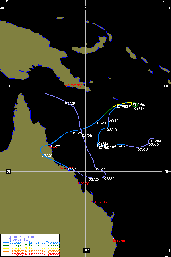
It seems that in the monsoon trough there are several tropical lows in which Invest 91P & 93P are members of. Lets see which or whom develop into tropical cyclones in the next few days.
Last edited by HURAKAN on Sun Mar 04, 2007 11:03 am, edited 2 times in total.
0 likes   

User avatar
HURAKAN
Professional-Met
Professional-Met
Posts: 46086
Age: 38
Joined: Thu May 20, 2004 4:34 pm
Location: Key West, FL
Contact:

#2 Postby HURAKAN » Wed Feb 28, 2007 5:45 am

28/0833 UTC 15.7S 154.7E T1.5/1.5 93P -- South Pacific Ocean

HIGH SEAS WEATHER WARNING FOR METAREA 10 ISSUED BY THE AUSTRALIAN BUREAU OF
METEOROLOGY, BRISBANE 0708 UTC 28 February 2007

GALE WARNING FOR NORTH EASTERN AREA

SITUATION
At 280530UTC, a vigorous monsoon trough extends through the northern Coral Sea
with several embedded lows. Main low with central pressure 998 hPa was centred
within 60 nautical miles of 16.2S 153.0E, and is almost stationary. The low
should develop into a tropical cyclone in the next 24 hours.

AREA AFFECTED
Within 150 nautical miles of a line from 13.5S 149.0E to 16.2S 153.0E to 16.0S
160.0E.

FORECAST
W/NW winds 25/35 knots north of the line, and SE/E winds 25/35 knots south of
the line. Clockwise winds should increase to 35/40 knots within 120 nautical
miles of the main low in the next 12 to 24 hours. Seas rising to very rough.
Moderate to heavy NW and SE swells developing.

Forecast Position at 281800UTC 16.5S 151.0E Central Pressure 993hPa.
Forecast Position at 010600UTC 16.8S 150.5E Central Pressure 988hPa.


REMARKS
All ships in the area please send weather reports every three hours. Regular
weather observing ships use normal channels. Other ships please use either
email to marwxqld@bom.gov.au or fax to +61732200221 or satellite to SAC 41
through Land Earth Station Perth 222.

WEATHER BRISBANE
0 likes   

User avatar
HURAKAN
Professional-Met
Professional-Met
Posts: 46086
Age: 38
Joined: Thu May 20, 2004 4:34 pm
Location: Key West, FL
Contact:

#3 Postby HURAKAN » Wed Feb 28, 2007 1:47 pm

Image

Left: 91P, Right: 93P. Both systems look better organized.
0 likes   

User avatar
HURAKAN
Professional-Met
Professional-Met
Posts: 46086
Age: 38
Joined: Thu May 20, 2004 4:34 pm
Location: Key West, FL
Contact:

#4 Postby HURAKAN » Wed Feb 28, 2007 2:18 pm

THE AREA OF CONVECTION PREVIOUSLY LOCATED NEAR 14.8S
152.8E, IS NOW LOCATED NEAR 16.4S 154.8E, APPROXIMATELY 675 NM
NORTH OF BRISBANE, AUSTRALIA. RECENT ANIMATED MULTISPECTRAL
SATELLITE IMAGERY DEPICTS A WELL DEFINED MID LEVEL CIRCULATION
WITH STRONG CONVERGENCE ON THE WESTERN END OF THE MONSOON TROUGH.
UPPER LEVEL ANALYSIS INDICATES THAT THE CENTER IS LOCATED UNDER
AN ANTICYCLONE WITH WEAK TO MODERATE VERTICAL WIND SHEAR AND
GOOD DIFFLUENCE ALOFT. ANIMATED WATER VAPOR IMAGERY SHOWS GOOD
EQUATORWARD OUTFLOW AND STRONG POLEWARD OUTFLOW ORIENTED EAST-
SOUTHEASTWARD, WHICH IS BEING ENHANCED BY MIDLATITUDE WESTERLIES
AND TROUGHING SOUTH AND EAST OF THE SYSTEM. MAXIMUM SUSTAINED
SURFACE WINDS ARE ESTIMATED AT 25 TO 30 KNOTS. MINIMUM SEA LEVEL
PRESSURE IS ESTIMATED TO BE NEAR 1000 MB. BASED ON THE FAVORABLE
UPPER LEVEL ENVIRONMENT, THE POTENTIAL FOR THE DEVELOPMENT OF A
SIGNIFICANT TROPICAL CYCLONE WITHIN THE NEXT 24 HOURS REMAINS FAIR.
0 likes   

User avatar
HURAKAN
Professional-Met
Professional-Met
Posts: 46086
Age: 38
Joined: Thu May 20, 2004 4:34 pm
Location: Key West, FL
Contact:

#5 Postby HURAKAN » Wed Feb 28, 2007 8:42 pm

HIGH SEAS WEATHER WARNING FOR METAREA 10 ISSUED BY THE AUSTRALIAN BUREAU OF
METEOROLOGY, BRISBANE 2238 UTC 28 February 2007

GALE WARNING FOR NORTH EASTERN AREA

SITUATION
At 282230UTC, a vigorous monsoon trough extends from two tropical lows, one near
14S 148E central pressure 998hPa,the other near 16.5S 154E, central pressure
998hPa and then to to 15S 160E. These two lows are expected to interact, and a
tropical cyclone may form near 15S 150E in the next 24 hours. The low
currently near 14S 148E is expected to move northwest and parallel to the coast
today, before turning more northerly overnight.

AREA AFFECTED
Within 150 nautical miles of monsoon trough.

FORECAST
W/NW winds 30/35 knots north of the line, and SE/E winds 30/35 knots south of
the line. Clockwise winds should increase to 35/45 knots within 120 nautical
miles of 15S 150E in 24 hours. Seas rising to very rough. Moderate to heavy NW
and SE swells developing.


REMARKS
All ships in the area please send weather reports every three hours. Regular
weather observing ships use normal channels. Other ships please use either
email to marwxqld@bom.gov.au or fax to +61732200221 or satellite to SAC 41
through Land Earth Station Perth 222.

WEATHER BRISBANE
0 likes   

User avatar
HURAKAN
Professional-Met
Professional-Met
Posts: 46086
Age: 38
Joined: Thu May 20, 2004 4:34 pm
Location: Key West, FL
Contact:

#6 Postby HURAKAN » Wed Feb 28, 2007 8:43 pm

HIGH SEAS WEATHER WARNING FOR METAREA 10 ISSUED BY THE AUSTRALIAN BUREAU OF
METEOROLOGY, BRISBANE 0109 UTC 1 March 2007

GALE WARNING FOR NORTH EASTERN AREA

SITUATION
At 010100UTC, a vigorous monsoon trough extended from near 13S 144E to a 998 hpa
tropical low near 13.5S 148E to another tropical low of 998 hpa near 17.6S
152.6E to 15S160E. Te latter low is expected to develop into a tropical cyclone
in the next 24 to 48 hours. The low near 13.5S 148E is expected to move slowly
to the north-east and gradually decay.

AREA AFFECTED
Within 150 nautical miles of monsoon trough.

FORECAST
W/NW winds 30/35 knots north of the line and SE/E winds 30/35 knots south of the
line. Clockwise winds may increase to 35/45 knots within 120 nautical miles of
17.6S 152.6E during the next 24 hours. Seas rising to very rough. Moderate to
heavy NW and SE swells developing.


REMARKS
All ships in the area please send weather reports every three hours. Regular
weather observing ships use normal channels. Other ships please use either
email to marwxqld@bom.gov.au or fax to +61732200221 or satellite to SAC 41
through Land Earth Station Perth 222.

WEATHER BRISBANE
0 likes   

User avatar
HURAKAN
Professional-Met
Professional-Met
Posts: 46086
Age: 38
Joined: Thu May 20, 2004 4:34 pm
Location: Key West, FL
Contact:

#7 Postby HURAKAN » Thu Mar 01, 2007 7:15 am

Australian Government Bureau of Meteorology
Queensland
Tropical Cyclone Warning Centre

Media: This message is issued daily for the information of interested parties.
Media are NOT required to broadcast this message.

TROPICAL CYCLONE OUTLOOK
for the Coral Sea West of Longitude 160 East
Issued at 2:49pm on Thursday the 1st of March 2007

An active monsoon trough over northern Australia extends through the northern
tip of Cape York Peninsula and into the Coral Sea. It has been active with the
slow development of two lows, the deeper low near 18S152E which is expected to
move slowly WSW and a second low situated near 14S147E and is expected to move
gradually north during next 24 hours. Intensification has been slowed with both
systems under an upper ridge but within a moderately sheared environment.
Development is expected to re-occur during the next 12 hours with the low near
18S152E favoured for cyclone formation.

The potential for tropical cyclone development over the northwest Coral Sea is
MODERATE for Thursday night, increasing to HIGH during Friday and HIGH for
Saturday/Sunday.
0 likes   

User avatar
HURAKAN
Professional-Met
Professional-Met
Posts: 46086
Age: 38
Joined: Thu May 20, 2004 4:34 pm
Location: Key West, FL
Contact:

#8 Postby HURAKAN » Thu Mar 01, 2007 3:48 pm

Image

HIGH SEAS WEATHER WARNING FOR METAREA 10 ISSUED BY THE AUSTRALIAN BUREAU OF
METEOROLOGY, BRISBANE 1834 UTC 1 March 2007

GALE WARNING FOR NORTH EASTERN AREA

SITUATION
At 011800UTC, a vigorous monsoon trough extended from near 12.0S 145.0E to a
tropical low of 993 hpa within 20 nautical miles of 17.3S 151.2E then to 15.0S
160.0E. The low will remain near stationary and may develop into a tropical
cyclone in the next 24 hours.

AREA AFFECTED
Within 120 nautical miles of the low and within a 100 nm on the northern side of
the monsoon trough east of 145E.

FORECAST
Expect clockwise winds 30/40 knots near the low increasing to 35/45 knots
during the next 24 hours. Expect W/NW winds 30/40 knots over the remaining area.
Seas very rough. Moderate to heavy swells.

REMARKS
All ships in the area please send weather reports every three hours. Regular
weather observing ships use normal channels. Other ships please use either
email to marwxqld@bom.gov.au or fax to +61732200221 or satellite to SAC 41
through Land Earth Station Perth 222.

WEATHER BRISBANE
0 likes   

User avatar
Chacor
Category 5
Category 5
Posts: 10229
Joined: Mon Oct 02, 2006 10:43 pm
Location: Singapore

#9 Postby Chacor » Fri Mar 02, 2007 7:10 am

Image

IDQP0005
Australian Government Bureau of Meteorology
Queensland
Tropical Cyclone Warning Centre

Media: The Standard Emergency Warning Signal should NOT be used with this
message.


PRIORITY
TROPICAL CYCLONE ADVICE NUMBER 1
Issued by the Bureau of Meteorology, Brisbane
Issued at 4:26pm on Friday the 2nd of March 2007

A Cyclone WATCH has been declared for coastal and island communities between Ayr
and St Lawrence, including the Whitsunday Islands.

At 3:00 pm EST a Tropical Low, with central pressure 996 hectopascals, was
centred near latitude 16.7 south and longitude 151.1 east which is 440
kilometres north northeast of Hayman Is and 535 kilometres north northeast of
Mackay.

The low is currently near stationary, and is expected to remain slow moving in
the next 48 hours. The TROPICAL LOW is expected to intensify into a TROPICAL
CYCLONE by Saturday night. GALES could develop on the coast and Islands between
Ayr and St. Lawrence later on Sunday as the system intensifies.

Details of Tropical Low, for 3:00 pm EST
Central Pressure : 996 hectopascals
Location of Centre : within 40 kilometres of
: latitude 16.7 degrees south
: longitude 151.1 degrees east
: which is 440 kilometres north northeast of Hayman Is
: and 535 kilometres north northeast of Mackay
Recent Movement : near stationary
Maximum wind gusts : 85 kilometres per hour and slowly INTENSIFYING

People between Ayr and St. Lawrence should consider what action they will need
to take if the cyclone threat increases. If you are unsure about the actions to
be taken, information is available from your local government or local State
Emergency Service.

The next advice will be issued by 11:00 pm EST

This warning is also available through TV and Radio Broadcasts; the Bureau's
website at http://www.bom.gov.au or call 1300 659 212. The Bureau and the State
Emergency Service would appreciate this warning being broadcast regularly.
Last edited by Chacor on Fri Mar 02, 2007 8:42 am, edited 1 time in total.
0 likes   

User avatar
HURAKAN
Professional-Met
Professional-Met
Posts: 46086
Age: 38
Joined: Thu May 20, 2004 4:34 pm
Location: Key West, FL
Contact:

#10 Postby HURAKAN » Fri Mar 02, 2007 8:37 am

TROPICAL CYCLONE ADVICE NUMBER 2
Issued by the Bureau of Meteorology, Brisbane
Issued at 10:53pm on Friday the 2nd of March 2007

A Cyclone WATCH remains current for coastal and island communities between Ayr
and St Lawrence.

At 10:00 pm EST a Tropical Low, with central pressure 996 hectopascals, was
centred near latitude 16.8 south and longitude 152.5 east which is
525 kilometres northeast of Hayman Is and 600 kilometres northeast of Mackay.

The TROPICAL LOW is currently near stationary and is expected to remain slow
moving during the weekend.
The LOW is expected to form into a TROPICAL CYCLONE overnight Saturday.
GALES could develop on the exposed coast and Islands between Ayr and
St. Lawrence on Sunday as the cyclone intensifies.


Details of Tropical Low, for 10:00 pm EST
Central Pressure : 996 hectopascals
Location of Centre : within 55 kilometres of
: latitude 16.8 degrees south
: longitude 152.5 degrees east
: which is 525 kilometres northeast of Hayman Is
: and 600 kilometres northeast of Mackay
Recent Movement : near stationary
Maximum wind gusts : 85 kilometres per hour and INTENSIFYING

People between Ayr and St. Lawrence should consider what action they will need
to take if the cyclone threat increases. If you are unsure about the actions to
be taken, information is available from your local government or local State
Emergency Service.

The next advice will be issued by 5:00 am EST Saturday.
0 likes   

User avatar
Chacor
Category 5
Category 5
Posts: 10229
Joined: Mon Oct 02, 2006 10:43 pm
Location: Singapore

#11 Postby Chacor » Fri Mar 02, 2007 9:03 am

The next Brisbane name is Odette.
0 likes   

User avatar
HURAKAN
Professional-Met
Professional-Met
Posts: 46086
Age: 38
Joined: Thu May 20, 2004 4:34 pm
Location: Key West, FL
Contact:

#12 Postby HURAKAN » Fri Mar 02, 2007 2:20 pm

TROPICAL CYCLONE ADVICE NUMBER 3
Issued by the Bureau of Meteorology, Brisbane
Issued at 4:36am on Saturday the 3rd of March 2007

A Cyclone WATCH has is current for coastal and island communities from Ayr to St
Lawrence.

At 4:00 am EST a Tropical Low, with central pressure 996 hectopascals, was
centred near latitude 17.2 south and longitude 153.3 east which is 560
kilometres northeast of Hayman Is and 620 kilometres northeast of Mackay.

The TROPICAL LOW is currently near stationary and is expected to remain slow
moving during the weekend.
The LOW is expected to form into a TROPICAL CYCLONE overnight Saturday into
Sunday morning.
GALES could develop on the exposed coast and Islands between Ayr and St.
Lawrence early on Monday as the cyclone intensifies.


Details of Tropical Low, for 4:00 am EST
Central Pressure : 996 hectopascals
Location of Centre : within 40 kilometres of
: latitude 17.2 degrees south
: longitude 153.3 degrees east
: which is 560 kilometres northeast of Hayman Is
: and 620 kilometres northeast of Mackay
Recent Movement : near stationary
Maximum wind gusts : 85 kilometres per hour and INTENSIFYING

People between Ayr and St. Lawrence should consider what action they will need
to take if the cyclone threat increases. If you are unsure about the actions to
be taken, information is available from your local
government or local State Emergency Service.

The next advice will be issued by 11:00 am EST
0 likes   

User avatar
HURAKAN
Professional-Met
Professional-Met
Posts: 46086
Age: 38
Joined: Thu May 20, 2004 4:34 pm
Location: Key West, FL
Contact:

#13 Postby HURAKAN » Fri Mar 02, 2007 8:40 pm

02/2033 UTC 17.9S 154.4E T2.0/2.0 93P -- South Pacific Ocean

Image

Odette may form soon.
0 likes   

User avatar
P.K.
Professional-Met
Professional-Met
Posts: 5149
Joined: Thu Sep 23, 2004 5:57 pm
Location: Watford, England
Contact:

#14 Postby P.K. » Fri Mar 02, 2007 8:43 pm

This has just been named TC Odette.
0 likes   

User avatar
Chacor
Category 5
Category 5
Posts: 10229
Joined: Mon Oct 02, 2006 10:43 pm
Location: Singapore

#15 Postby Chacor » Fri Mar 02, 2007 8:55 pm

748
WTAU01 ABRF 030148
IDQ20008
SECURITE

HIGH SEAS WEATHER WARNING FOR METAREA 10 ISSUED BY THE AUSTRALIAN BUREAU OF
METEOROLOGY, BRISBANE 0147 UTC 3 March 2007

GALE WARNING FOR NORTH EASTERN AREA

SITUATION
At 0000 UTC Tropical Cyclone Odette 991 hPa was centred within 30 nautical miles
of 16.6 S 154.8 E and slow moving.

AREA AFFECTED
Within 240 nautical miles of the centre
FORECAST
Clockwise winds 30/40 knots.
Seas rising to very rough and moderate to heavy swells developing.

Forecast positions
At 1200 UTC 03 March: Within 70 nautical miles of 16.9 south 154.5 east
Central pressure 989 hPa.
Winds to 40 knots.
At 0000 UTC 04 March: Within 100 nautical miles of 16.6 south 153.9 east
Central pressure 987 hPa.
Winds to 45 knots.

REMARKS
All ships in the area please send weather reports every three hours. egular
weather observing ships use normal channels. Other ships please use either
email to marwxqld@bom.gov.au or fax to +61732398776 or satellite to SAC 41
through Land Earth Station Perth 222.
Next warning issued by 0700 UTC 03 March 2007.
WEATHER BRISBANE
0 likes   

User avatar
HURAKAN
Professional-Met
Professional-Met
Posts: 46086
Age: 38
Joined: Thu May 20, 2004 4:34 pm
Location: Key West, FL
Contact:

#16 Postby HURAKAN » Fri Mar 02, 2007 9:00 pm

P.K. wrote:This has just been named TC Odette.


They heard me!!!
0 likes   

User avatar
HURAKAN
Professional-Met
Professional-Met
Posts: 46086
Age: 38
Joined: Thu May 20, 2004 4:34 pm
Location: Key West, FL
Contact:

#17 Postby HURAKAN » Fri Mar 02, 2007 9:13 pm

Image

Odette's past and future track.
0 likes   

HurricaneBill
Category 5
Category 5
Posts: 3420
Joined: Sun Apr 11, 2004 5:51 pm
Location: East Longmeadow, MA, USA

#18 Postby HurricaneBill » Fri Mar 02, 2007 10:48 pm

Is that a track or dance steps?
0 likes   

User avatar
AussieMark
Category 5
Category 5
Posts: 5858
Joined: Tue Sep 02, 2003 6:36 pm
Location: near Sydney, Australia

#19 Postby AussieMark » Fri Mar 02, 2007 11:15 pm

thats almost as Crazy as Justin of March 1997 :lol:
0 likes   

User avatar
HURAKAN
Professional-Met
Professional-Met
Posts: 46086
Age: 38
Joined: Thu May 20, 2004 4:34 pm
Location: Key West, FL
Contact:

#20 Postby HURAKAN » Fri Mar 02, 2007 11:29 pm

AussieMark wrote:thats almost as Crazy as Justin of March 1997 :lol:


Image

Right!!!
0 likes   


Return to “Talkin' Tropics”

Who is online

Users browsing this forum: dl20415, HurricaneBelle, Kludge, Pelicane, SconnieCane, Stratton23 and 105 guests