TC George: preliminary report issued

This is the general tropical discussion area. Anyone can take their shot at predicting a storms path.

Moderator: S2k Moderators

Forum rules

The posts in this forum are NOT official forecasts and should not be used as such. They are just the opinion of the poster and may or may not be backed by sound meteorological data. They are NOT endorsed by any professional institution or STORM2K. For official information, please refer to products from the National Hurricane Center and National Weather Service.

Help Support Storm2K
Message
Author
User avatar
Chacor
Category 5
Category 5
Posts: 10229
Joined: Mon Oct 02, 2006 10:43 pm
Location: Singapore

TC George: preliminary report issued

#1 Postby Chacor » Tue Feb 27, 2007 10:34 am

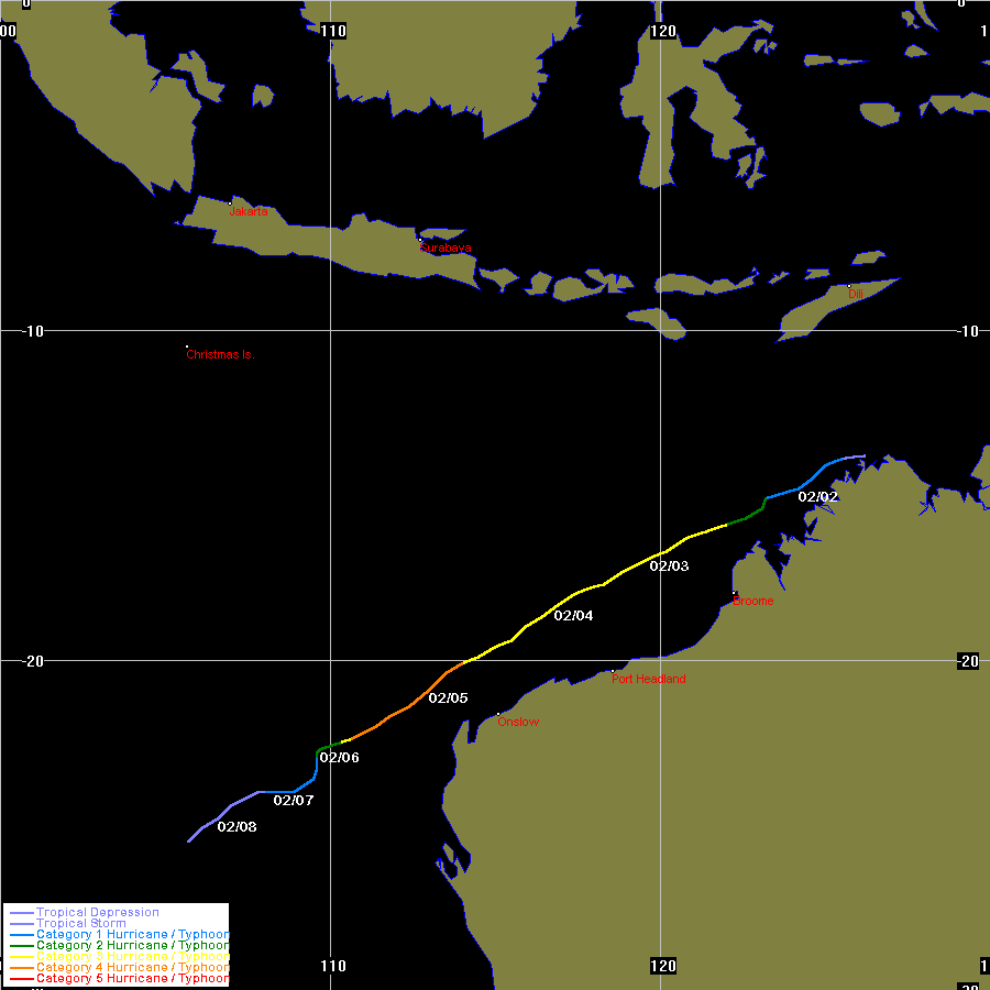
Image

Image

TROPICAL CYCLONE OUTLOOK
FOR THE AREA BETWEEN LONGITUDES 125 EAST - 142 EAST
Issued by the BUREAU OF METEOROLOGY, DARWIN
at 2:15 pm CST Tuesday 27 February 2007

A developing TROPICAL LOW 1001 hPa is situated on the coast near Milingimbi.
At 12 noon it was near latitude 12.2S, longitude 134.8E, about 220 km west of
Nhulunbuy, and is slow moving. The LOW is expected to remain near the north
coast for the next few days but drift slowly east towards the Gulf of
Carpentaria.

If the low moves off the Arnhem coast and over water, the potential for
development into a Tropical Cyclone over the next few days is estimated to be:
Wednesday: low,
Thursday: low,
Friday: moderate.

NOTE: Development Potential is an estimate of the probability of tropical
cyclone development for each day... Low = 10% or less, Moderate = 20% - 40%,
High = 50% or more.

DARWIN Regional Forecasting Centre.
Last edited by Chacor on Tue Mar 13, 2007 9:56 am, edited 13 times in total.
0 likes   

User avatar
HURAKAN
Professional-Met
Professional-Met
Posts: 46086
Age: 38
Joined: Thu May 20, 2004 4:34 pm
Location: Key West, FL
Contact:

#2 Postby HURAKAN » Wed Feb 28, 2007 5:43 am

TROPICAL CYCLONE OUTLOOK
FOR THE AREA BETWEEN LONGITUDES 125 EAST - 142 EAST
Issued by the BUREAU OF METEOROLOGY, DARWIN
at 2:15 pm CST Wednesday 28 February 2007

A TROPICAL LOW 998 hPa is situated on the coast near Milingimbi. At 9 am it was
near latitude 12.3S, longitude 134.5E, about 250km west of Nhulunbuy, and is
slow moving. The LOW is expected to remain near the north coast for the next few
days but drift slowly east towards the Gulf of Carpentaria.

If the low moves off the Arnhem coast and over water, the potential for
development into a Tropical Cyclone over the next few days is estimated to be:
Thursday: moderate,
Friday: high,
Saturday: high.

NOTE: Development Potential is an estimate of the probability of tropical
cyclone development for each day... Low = 10% or less, Moderate = 20% - 40%,
High = 50% or more.

DARWIN Regional Forecasting Centre.
0 likes   

User avatar
HURAKAN
Professional-Met
Professional-Met
Posts: 46086
Age: 38
Joined: Thu May 20, 2004 4:34 pm
Location: Key West, FL
Contact:

#3 Postby HURAKAN » Wed Feb 28, 2007 1:49 pm

Image

The system looks to be partially inland. It should get better organized once it gets to the Gulf of Carpentaria.
0 likes   

User avatar
HURAKAN
Professional-Met
Professional-Met
Posts: 46086
Age: 38
Joined: Thu May 20, 2004 4:34 pm
Location: Key West, FL
Contact:

#4 Postby HURAKAN » Wed Feb 28, 2007 8:45 pm

Australian Government Bureau of Meteorology
Northern Territory
Darwin Regional Forecasting Centre

40:2:1:24:08S133E900:11:00
SECURITE

HIGH SEAS WEATHER WARNING

HIGH SEAS WEATHER WARNING FOR METAREA 10/11
Issued by the AUSTRALIAN BUREAU OF METEOROLOGY, DARWIN
Issued at 0130 UTC 1 MARCH 2007

PLEASE BE AWARE
Wind gusts can be a further 40 percent stronger than the averages given here,
and maximum waves may be up to twice the height.

GALE WARNING FOR NORTHERN AREA

SITUATION
At 0000 UTC Tropical Low 996 hPa centred within 70 nautical miles of 12.3 S
135.4 E slow moving.

AREA AFFECTED
Within 150 nautical miles of the centre, in the northern semicircle.

FORECAST
Southwest to northwest winds 30/40 knots. Very rough to high seas and moderate
to heavy swell.

1200 UTC 01 March:
Within 90 nautical miles of 12.4 S 135.1 E over land.
Central pressure 996hPa.
0000 UTC 02 March:
Within 130 nautical miles of 12.6 S 134.0 E over land.
Central pressure 995hPa.

REMARKS
Ships in the general area please transmit 3-hourly weather reports.

The next warning will be issued by 0730 UTC 01 March 2007.

DARWIN Tropical Cyclone Warning Centre
0 likes   

User avatar
HURAKAN
Professional-Met
Professional-Met
Posts: 46086
Age: 38
Joined: Thu May 20, 2004 4:34 pm
Location: Key West, FL
Contact:

#5 Postby HURAKAN » Wed Feb 28, 2007 9:10 pm

Image

Famous words, "trouble in the tropics."
0 likes   

User avatar
Chacor
Category 5
Category 5
Posts: 10229
Joined: Mon Oct 02, 2006 10:43 pm
Location: Singapore

#6 Postby Chacor » Thu Mar 01, 2007 3:18 am

WTAU03 ADRM 010729
IDD20130
AUSTRALIAN GOVERNMENT BUREAU OF METEOROLOGY
NORTHERN TERRITORY
DARWIN REGIONAL FORECASTING CENTRE

40:2:1:24:13S136E999:11:00
SECURITE

HIGH SEAS WEATHER WARNING

HIGH SEAS WEATHER WARNING FOR METAREA 10/11
ISSUED BY THE AUSTRALIAN BUREAU OF METEOROLOGY, DARWIN
ISSUED AT 0724 UTC 1 MARCH 2007

PLEASE BE AWARE
WIND GUSTS CAN BE A FURTHER 40 PERCENT STRONGER THAN THE AVERAGES GIVEN HERE,
AND MAXIMUM WAVES MAY BE UP TO TWICE THE HEIGHT.

GALE WARNING FOR NORTHERN AREA

SITUATION
AT 0600 UTC TROPICAL LOW 995 HPA CENTRED/ESTIMATED WITHIN 50 NAUTICAL MILES OF
12.7 S 135.7 E, MOVING SOUTHEAST AT 5 KNOTS. THE LOW IS NOT EXPECTED TO DEVELOP
INTO A TROPICAL CYCLONE IN THE NEXT 24 HOURS.

AREA AFFECTED
WITHIN 150 NAUTICAL MILES OF THE CENTRE IN THE NORTHERN SEMICIRCLE.

FORECAST
SOUTHWEST TO NORTHWEST WINDS 30/40 KNOTS. VERY ROUGH TO HIGH SEAS AND MODERATE
TO HEAVY SWELL.

1800 UTC 01 MARCH: WITHIN 85 NAUTICAL MILES OF 12.8 S 135.3 E OVER LAND.
CENTRAL PRESSURE 994 HPA.
0600 UTC 02 MARCH: WITHIN 110 NAUTICAL MILES OF 13.0 S 134.4 E OVER LAND.
CENTRAL PRESSURE 992 HPA.

REMARKS
SHIPS IN THE GENERAL AREA PLEASE TRANSMIT 3-HOURLY WEATHER REPORTS.

NEXT WARNING ISSUED BY 1330 UTC 01 MARCH 2007.

DARWIN TROPICAL CYCLONE WARNING CENTRE
0 likes   

User avatar
HURAKAN
Professional-Met
Professional-Met
Posts: 46086
Age: 38
Joined: Thu May 20, 2004 4:34 pm
Location: Key West, FL
Contact:

#7 Postby HURAKAN » Thu Mar 01, 2007 3:43 pm

Continues to amaze but still over land and that's not good for development into a tropical cyclone.

Image
0 likes   

User avatar
HURAKAN
Professional-Met
Professional-Met
Posts: 46086
Age: 38
Joined: Thu May 20, 2004 4:34 pm
Location: Key West, FL
Contact:

#8 Postby HURAKAN » Fri Mar 02, 2007 7:45 am

Image

It should become a cyclone shortly after touching the ocean.

TROPICAL CYCLONE ADVICE NUMBER 1
Issued by the BUREAU OF METEOROLOGY, DARWIN
at 5:00 pm CST [4:30 pm WDT] Friday 2 March 2007

A CYCLONE WATCH has been declared for coastal and island communities from DALY
RIVER MOUTH in the Northern Territory to MITCHELL PLATEAU in Western Australia.

At 4 pm CST [4.30 pm WDT] a TROPICAL LOW was centred inland over the northern
Top End about 75 kilometres south southeast of OENPELLI and moving west at
12 kilometres per hour towards the Timor Sea.

MONSOONAL GALES with gusts to 90 kilometres per hour are currently being
experienced along the north coast of the Top End and may extend southwest to
DALY RIVER MOUTH during Saturday. There is the possibility of a cyclone forming
in the Timor Sea on Sunday with GALES developing in coastal areas between DALY
RIVER MOUTH and MITCHELL PLATEAU.

Details of TROPICAL LOW at 4 pm CST [4.30 pm WDT]:
. Centre located near...... 13.0 degrees South 133.2 degrees East
. Location accuracy........ within 60 kilometres
. Recent movement.......... towards the west at 12 km/h
. Central pressure......... 996 hectoPascals

People from DALY RIVER MOUTH to MITCHELL PLATEAU should listen for the next
advice which will be issued at 11 pm CST [11.30 pm WDT].

This advice is available on telephone NT-1300 659 211 and WA-1300 659 210

DARWIN Tropical Cyclone Warning Centre
0 likes   

User avatar
HURAKAN
Professional-Met
Professional-Met
Posts: 46086
Age: 38
Joined: Thu May 20, 2004 4:34 pm
Location: Key West, FL
Contact:

#9 Postby HURAKAN » Fri Mar 02, 2007 8:36 am

TROPICAL CYCLONE ADVICE NUMBER 2
Issued by the BUREAU OF METEOROLOGY, DARWIN
at 11:00 pm CST [10:30 pm WDT] Friday 2 March 2007

A CYCLONE WATCH continues for coastal and island communities from DALY RIVER
MOUTH in the Northern Territory to MITCHELL PLATEAU in Western Australia.

At 9:30 pm CST [9:00 pm WDT] a TROPICAL LOW was centred inland over the northern
Top End about 75 kilometres south southwest of Oenpelli and is moving slowly
west towards the Timor Sea.

MONSOONAL GALES with gusts to 90 kilometres per hour are currently being
experienced along the north coast of the Top End and may extend southwest to
DALY RIVER MOUTH during Saturday. There is the possibility of a cyclone forming
in the Timor Sea on Sunday with GALES developing in coastal areas between DALY
RIVER MOUTH and MITCHELL PLATEAU.

Details of TROPICAL LOW at 9:30 pm CST [9:00 pm WDT]:
. Centre located near...... 12.9 degrees South 132.7 degrees East
. Location accuracy........ within 55 kilometres
. Recent movement.......... towards the west slowly
. Central pressure......... 997 hectoPascals

People from DALY RIVER MOUTH in the Northern Territory to MITCHELL PLATEAU in
Western Australia should listen for the next advice which will be issued at 5:00
am CST [4:30 am WDT].


This advice is available on telephone NT-1300 659 211 and WA-1300 659 210

DARWIN Tropical Cyclone Warning Centre
0 likes   

User avatar
Chacor
Category 5
Category 5
Posts: 10229
Joined: Mon Oct 02, 2006 10:43 pm
Location: Singapore

#10 Postby Chacor » Fri Mar 02, 2007 9:06 am

Next Darwin name is George; next Perth name is Jacob. If it moves far enough west, the next La Réunion name is Indlada.
0 likes   

User avatar
Chacor
Category 5
Category 5
Posts: 10229
Joined: Mon Oct 02, 2006 10:43 pm
Location: Singapore

#11 Postby Chacor » Fri Mar 02, 2007 9:32 am

Looking at the Australian Severe Weather Cyclones archive page, no storm (going back to 84/85) has ever been named by both Darwin and Mauritius (although 97/98's Victor-Cindy came close, but ultimately Victor was a Perth name).

The last year without a BOM-Mauritius naming change was 94/95.
0 likes   

User avatar
HURAKAN
Professional-Met
Professional-Met
Posts: 46086
Age: 38
Joined: Thu May 20, 2004 4:34 pm
Location: Key West, FL
Contact:

#12 Postby HURAKAN » Fri Mar 02, 2007 9:58 am

Chacor wrote:Next Darwin name is George; next Perth name is Jacob. If it moves far enough west, the next La Réunion name is Indlada.


This system is a Glenda-like storm, which looked very good on land, and then when it moved over water it explosively intensified. NOGAPS shows an intensifying storm coming out of the Darwin-area and making landfall in 180 hrs (7.5 days) in the westernmost area of WA. It seems it will not go west of 90ºE.

Image
0 likes   

User avatar
Chacor
Category 5
Category 5
Posts: 10229
Joined: Mon Oct 02, 2006 10:43 pm
Location: Singapore

#13 Postby Chacor » Fri Mar 02, 2007 10:21 am

There's now a 94S just west of 92S, so maybe that's what NOGAPS picked up on?
0 likes   

User avatar
HURAKAN
Professional-Met
Professional-Met
Posts: 46086
Age: 38
Joined: Thu May 20, 2004 4:34 pm
Location: Key West, FL
Contact:

#14 Postby HURAKAN » Fri Mar 02, 2007 12:39 pm

Chacor wrote:There's now a 94S just west of 92S, so maybe that's what NOGAPS picked up on?


NOGAPS is picking up on something coming out of the Darwin-area, which is Invest 92S.

Image

Looking more and more impressive by the minute.
0 likes   

User avatar
HURAKAN
Professional-Met
Professional-Met
Posts: 46086
Age: 38
Joined: Thu May 20, 2004 4:34 pm
Location: Key West, FL
Contact:

#15 Postby HURAKAN » Fri Mar 02, 2007 2:20 pm

TROPICAL CYCLONE ADVICE NUMBER 3
Issued by the BUREAU OF METEOROLOGY, DARWIN
at 5:00 am CST [4:30 am WDT] Saturday 3 March 2007

A CYCLONE WATCH is now current for coastal and island communities from DALY
RIVER MOUTH in the Northern Territory to KURI BAY in Western Australia.

At 3:30 am CST [3:00 am WDT] a TROPICAL LOW was centred inland over the
northwest Top End about 110 kilometres southeast of Darwin and is moving west
southwest at 16 kilometres per hour.

MONSOONAL GALES with gusts to 90 kilometres per hour are currently being
experienced along the north coast of the Top End and may extend southwest to
DALY RIVER MOUTH during today. There is the possibility of a cyclone forming in
the Timor Sea on Sunday with GALES developing in coastal areas between DALY
RIVER MOUTH and MITCHELL PLATEAU.

Details of TROPICAL LOW at 3:30 am CST [3:00 am WDT]:
. Centre located near...... 13.2 degrees South 131.5 degrees East
. Location accuracy........ within 55 kilometres
. Recent movement.......... towards the west southwest at 16 kilometres per
hour
. Central pressure......... 995 hectoPascals

People from DALY RIVER MOUTH in the Northern Territory to KURI BAY in Western
Australia should listen for the next advice which will be issued by 11:00 am CST
[10:30 am WDT].


This advice is available on telephone NT-1300 659 211 and WA-1300 659 210

DARWIN Tropical Cyclone Warning Centre
0 likes   

User avatar
HURAKAN
Professional-Met
Professional-Met
Posts: 46086
Age: 38
Joined: Thu May 20, 2004 4:34 pm
Location: Key West, FL
Contact:

#16 Postby HURAKAN » Fri Mar 02, 2007 6:48 pm

Image

Image
0 likes   

User avatar
HURAKAN
Professional-Met
Professional-Met
Posts: 46086
Age: 38
Joined: Thu May 20, 2004 4:34 pm
Location: Key West, FL
Contact:

#17 Postby HURAKAN » Fri Mar 02, 2007 8:31 pm

TROPICAL CYCLONE ADVICE NUMBER 4
Issued by the BUREAU OF METEOROLOGY, DARWIN
at 11:00 am CST [10:30 am WDT] Saturday 3 March 2007

A CYCLONE WARNING has been declared for coastal communities from Daly River
Mouth in the NT to Kalumburu.
A CYCLONE WATCH extends west to is now current for coastal and island
communities from Kalumburu to Kuri Bay in WA.

At 9:30 am CST [9:00 am WDT] a TROPICAL LOW was centred inland over the
northwest Top End about 100 kilometres south of Darwin and is moving west
southwest at 9 kilometres per hour. The low is expected to develop into a
tropical cyclone in the southeastern Timor Sea early on Sunday. The cyclone is
expected to move closer to the far north Kimberley coast between WYNDHAM and
KALUMBURU later on Sunday.

STRONG MONSOONAL WINDS with gusts to 90 kilometres per hour are currently being
experienced along the northwest coast of the Top End and may extend southwest to
PORT KEATS later today.

GALES with gusts to 110 kilometres per hour are expected to develop on the coast
between DALY RIVER MOUTH and KALUMBURU early Sunday morning, and may extend
further west to KURI BAY Sunday night or Monday morning.

DESTRUCTIVE WINDS with gusts to 130 kilometres per hour could develop on the
north Kimberley coast between WYNDHAM and KALUMBURU later on Sunday if the
cyclone intensifies.

ABNORMALLY HIGH TIDES could cause MINOR FLOODING at the coast between WYNDHAM
and KALUMBURU later on Sunday.

HEAVY RAIN is causing widesread flooding in the northwest Top End. Heavy rain
and flooding of low-lying areas is expected to extend into the far north
Kimberley on Sunday.

Details of TROPICAL LOW at 9:30 am CST [9:00 am WDT]:
. Centre located near...... 13.3 degrees South 130.8 degrees East
. Location accuracy........ within 55 kilometres
. Recent movement.......... towards the west southwest at 9 kilometres per hour
. Wind gusts near centre... 85 kilometres per hour
. Central pressure......... 996 hectoPascals

REPEATING: A CYCLONE WARNING is now current from Daly River Mouth in the NT to
Kalumburu.
A CYCLONE WATCH is now current from Kalumburu to Kuri Bay in WA.

The NEXT ADVICE will be issued at 2:00 pm CST [1:30 pm WDT]

This advice is available on telephone NT-1300 659 211 and WA-1300 659 210

DARWIN Tropical Cyclone Warning Centre

_____________________________________________________________________________________________________________

HIGH SEAS WEATHER WARNING FOR METAREA 10/11
Issued by the AUSTRALIAN BUREAU OF METEOROLOGY, DARWIN
Issued at 0121 UTC 3 MARCH 2007

PLEASE BE AWARE
Wind gusts can be a further 40 percent stronger than the averages given here,
and maximum waves may be up to twice the height.

GALE WARNING FOR NORTHERN AREA

SITUATION
At 0000 UTC Tropical Low 996 hPa centred/estimated over land within 30 nautical
miles of 13.3 S 130.8 E moving west southwest at 5 knots.
The low is expected to develop into a tropical cyclone in the next 12-24 hours.

AREA AFFECTED
Within 60 nautical miles of the centre and within 150 nautical miles of the
centre in the northern semicircle.

FORECAST
Clockwise winds 20/30 knots expected to increase to 35/45 knots within 12-24
hours.
Southwest to northwest winds 30/40 knots within 150 nautical miles in the
northern semicircle. Very rough to high seas and moderate to heavy swell.

1200 UTC 03 March: Within 60 nautical miles of 13.8 S 129.9 E near the coast.
Central pressure 993 hPa.
Winds to 30 knots near centre.
0000 UTC 04 March: Within 90 nautical miles of 13.9 S 128.5 E.
Central pressure 988 hPa.
Winds to 45 knots near centre.

REMARKS
Ships in the general area please transmit 3-hourly weather reports.

Next warning issued by 0730 UTC 03 March 2007.

DARWIN Tropical Cyclone Warning Centre
0 likes   

User avatar
HURAKAN
Professional-Met
Professional-Met
Posts: 46086
Age: 38
Joined: Thu May 20, 2004 4:34 pm
Location: Key West, FL
Contact:

#18 Postby HURAKAN » Fri Mar 02, 2007 11:22 pm

TROPICAL CYCLONE ADVICE NUMBER 5
Issued by the BUREAU OF METEOROLOGY, DARWIN
at 2:00 pm CST Saturday 3 March 2007

A CYCLONE WARNING has been declared for coastal communities from Daly River
Mouth in the NT to Kalumburu in WA.
A CYCLONE WATCH extends west to is now current for coastal and island
communities from Kalumburu to Kuri Bay in WA.

At 12:30 pm CST [12:00 pm WDT] a TROPICAL LOW was centred inland over the
northwest Top End about 140 kilometres south southwest of Darwin and is moving
southwest at 13 kilometres per hour. The low is expected to develop into a
tropical cyclone in the southeastern Timor Sea early on Sunday. The system is
expected to move closer to the far north Kimberley coast between WYNDHAM and
KALUMBURU later on Sunday.

STRONG MONSOONAL WINDS with gusts to 90 kilometres per hour are currently being
experienced along the northwest coast of the Top End, extending southwest into
the north Kimberley later today.

GALES with gusts to 110 kilometres per hour are expected to develop on the coast
between DALY RIVER MOUTH and KALUMBURU early Sunday morning, and may extend
further west to KURI BAY Sunday night or Monday morning.

DESTRUCTIVE WINDS with gusts to 130 kilometres per hour could develop on the
north Kimberley coast between WYNDHAM and KALUMBURU later on Sunday if the
system continues to intensify.

ABNORMALLY HIGH TIDES could cause MINOR FLOODING at the coast between WYNDHAM
and KALUMBURU later on Sunday.

HEAVY RAIN is causing widespread flooding in the northwest Top End. Heavy rain
and flooding of low-lying areas is expected to extend into the far north
Kimberley on Sunday.
Details of TROPICAL LOW at 12:30 pm CST [12:00 pm WDT]:
. Centre located near...... 13.6 degrees South 130.5 degrees East
. Location accuracy........ within 55 kilometres
. Recent movement.......... towards the southwest at 13 kilometres per hour
. Wind gusts near centre... 85 kilometres per hour
. Central pressure......... 998 hectoPascals

REPEATING: A CYCLONE WARNING is now current from Daly River Mouth in the NT to
Kalumburu in WA.
A CYCLONE WATCH is now current from Kalumburu to Kuri Bay in WA.

The NEXT ADVICE will be issued at 5:00 pm CST [4:30 pm WDT]

This advice is available on telephone NT-1300 659 211 and WA-1300 659 210

DARWIN Tropical Cyclone Warning Centre
0 likes   

User avatar
HURAKAN
Professional-Met
Professional-Met
Posts: 46086
Age: 38
Joined: Thu May 20, 2004 4:34 pm
Location: Key West, FL
Contact:

#19 Postby HURAKAN » Fri Mar 02, 2007 11:30 pm

Image

The last Jacob!!!
0 likes   

User avatar
HURAKAN
Professional-Met
Professional-Met
Posts: 46086
Age: 38
Joined: Thu May 20, 2004 4:34 pm
Location: Key West, FL
Contact:

#20 Postby HURAKAN » Sat Mar 03, 2007 8:59 am

TROPICAL CYCLONE ADVICE NUMBER 8
Issued by the BUREAU OF METEOROLOGY, DARWIN
at 11:07 pm CST Saturday 3 March 2007

A CYCLONE WARNING is now current for coastal and island communities from
Mitchell Plateau to Daly River Mouth.
A CYCLONE WATCH extends southwest to Cockatoo Island in WA.

At 9:30 pm CST [9:00 pm WDT] a TROPICAL LOW was in the Joseph Bonaparte Gulf
about 25 kilometres north northwest of Port Keats and 300 kilometres east of
Kalumburu, and is moving west southwest at 11 kilometres per hour. The low is
expected to develop into a tropical cyclone in the southeastern Timor Sea early
on Sunday. The system is expected to move closer to the far north Kimberley
coast between WYNDHAM and KALUMBURU later on Sunday.

STRONG MONSOONAL WINDS with gusts to 90 kilometres per hour are currently being
experienced along the northwest coast of the Top End, extending southwest into
the north Kimberley overnight.

GALES with gusts to 110 kilometres per hour are expected to develop on the coast
between DALY RIVER MOUTH and MITCHELL PLATEAU on Sunday morning, and may extend
further west to COCKATOO ISLAND on Monday.

DESTRUCTIVE WINDS with gusts to 130 kilometres per hour could develop on the
north Kimberley coast between WYNDHAM and MITCHELL PLATEAU later on Sunday if
the system continues to intensify.

ABNORMALLY HIGH TIDES could cause MINOR FLOODING at the coast between WYNDHAM
and KALUMBURU later on Sunday.

HEAVY RAIN is causing widespread flooding in the western Top End. Heavy rain is
expected to extend into the far north Kimberley on Sunday, causing flooding of
low-lying areas.

Details of TROPICAL LOW at 9:30 pm CST [9:00 pm WDT]:
. Centre located near...... 14.0 degrees South 129.4 degrees East
. Location accuracy........ within 55 kilometres
. Recent movement.......... towards the west southwest at 11 kilometres per
hour
. Wind gusts near centre... 85 kilometres per hour
. Central pressure......... 994 hectoPascals

REPEATING: A CYCLONE WARNING is now current for coastal and island communities
from Mitchell Plateau to Daly River Mouth.
A CYCLONE WATCH extends southwest to Cockatoo Island in WA.

The NEXT ADVICE will be issued at 2:00 am CST [1:30 am WDT]

This advice is available on telephone NT-1300 659 211 and WA-1300 659 210

DARWIN Tropical Cyclone Warning Centre
0 likes   


Return to “Talkin' Tropics”

Who is online

Users browsing this forum: HurricaneFan, Ian2401, Stratton23, tolakram and 66 guests