Major tornado outbreak, High Plains, March 28
Moderator: S2k Moderators
Forum rules

The posts in this forum are NOT official forecast and should not be used as such. They are just the opinion of the poster and may or may not be backed by sound meteorological data. They are NOT endorsed by any professional institution or STORM2K.
-
Matt-hurricanewatcher
-
ncupsscweather

- Category 1

- Posts: 321
- Age: 38
- Joined: Tue Jan 02, 2007 8:05 pm
- Location: Hickory,North Carolina


-
HURAKAN

- Professional-Met

- Posts: 46084
- Age: 39
- Joined: Thu May 20, 2004 4:34 pm
- Location: Key West, FL
- Contact:
http://www.10tv.com/?sec=news&story=sit ... 36632.html
There is a video of the damage caused by the deadly tornado in Oklahoma.
There is a video of the damage caused by the deadly tornado in Oklahoma.
0 likes
-
ncupsscweather
- Category 1
- Posts: 321
- Age: 38
- Joined: Tue Jan 02, 2007 8:05 pm
- Location: Hickory,North Carolina
-
ncupsscweather
- Category 1
- Posts: 321
- Age: 38
- Joined: Tue Jan 02, 2007 8:05 pm
- Location: Hickory,North Carolina
-
HarlequinBoy

- Category 5

- Posts: 1400
- Age: 35
- Joined: Wed Nov 29, 2006 1:57 am
- Location: Memphis
Matt-hurricanewatcher wrote:Would you place this outbreak any where near the late March in April outbreaks last year?
I would, although a lot of the information is preliminary right now.
Obviously this outbreak has nowhere near as many fatalities as March 11/12 or April 7, or for sure April 2, but it took place in a more rural area and had it been in a higher populated area I fear the damage would have been worse.
But just from reading and seeing the tornado reports and videos the tornadoes themselves look really impressive to me.
Oh, and I read on Wikipedia that a tornado killed someone south of Holly, Colorado. Did anyone else hear this?
0 likes
-
HurricaneBill
- Category 5
- Posts: 3419
- Joined: Sun Apr 11, 2004 5:51 pm
- Location: East Longmeadow, MA, USA
HarlequinBoy wrote:Oh, and I read on Wikipedia that a tornado killed someone south of Holly, Colorado. Did anyone else hear this?
I heard there were 4 tornado deaths.
2 in Oklahoma, 1 in Colorado, and 1 in Texas.
The fatality in Colorado would be the first tornado death in Colorado since 1960.
0 likes

-
HarlequinBoy
- Category 5
- Posts: 1400
- Age: 35
- Joined: Wed Nov 29, 2006 1:57 am
- Location: Memphis
HurricaneBill wrote:HarlequinBoy wrote:Oh, and I read on Wikipedia that a tornado killed someone south of Holly, Colorado. Did anyone else hear this?
I heard there were 4 tornado deaths.
2 in Oklahoma, 1 in Colorado, and 1 in Texas.
The fatality in Colorado would be the first tornado death in Colorado since 1960.
I knew about the 2 in Oklahoma, but not the one in CO or TX. I hope not.. it's already been such a deadly year. =[
0 likes
-
ncupsscweather
- Category 1
- Posts: 321
- Age: 38
- Joined: Tue Jan 02, 2007 8:05 pm
- Location: Hickory,North Carolina
-
Category 5

- Category 5
- Posts: 10074
- Age: 36
- Joined: Sun Feb 11, 2007 10:00 pm
- Location: New Brunswick, NJ
- Contact:
-
wxmann_91

- Category 5
- Posts: 8007
- Age: 34
- Joined: Fri Jul 15, 2005 2:49 pm
- Location: Southern California
- Contact:
Keep in mind that radar images and tornado pics don't justify ratings, damage does. The High Plains are among the least densely populated areas in the U.S. (second to some of the desert areas out west and SW TX).
So it's not really a surprise that two of the biggest tornadoes yesterday, the Bird City, KS tornado and the Perkins County, NE tornado, have both been rated an EF2.
http://www.crh.noaa.gov/crnews/display_ ... 4&source=0
http://www.crh.noaa.gov/lbf/?n=07march28tornadoes
So it's not really a surprise that two of the biggest tornadoes yesterday, the Bird City, KS tornado and the Perkins County, NE tornado, have both been rated an EF2.
http://www.crh.noaa.gov/crnews/display_ ... 4&source=0
http://www.crh.noaa.gov/lbf/?n=07march28tornadoes
0 likes

Yeah. Although I got some nice 3D rotational pictures, I've seen much stronger values out of some storms. The Enterprise, AL storm had NROT values pushing into the 2-2.5 range (same with the Linn County, KS EF4...that one peaked at around 2.8). I don't think there was anything I was getting last night that was pushing above 1.5. Granted, I know that value doesn't equate to particular EF ratings, but the rotation just wasn't as strong as I've seen it.
0 likes
-
Stephanie

- S2K Supporter

- Posts: 23843
- Age: 63
- Joined: Thu Feb 06, 2003 9:53 am
- Location: Glassboro, NJ
When you think of Colorado, your initial thought is of "The Rockies". It's easy to forget that the Eastern third of the state is a part of The Plains and as flat as a pancake. Those pictures of the devastation from Holly, CO are incredible, especially the one of a tree with all kinds of debris wrapped around it.
I guess it is fortunate that many of the tornadoes that did drop were in fairly unpopulated areas.
I guess it is fortunate that many of the tornadoes that did drop were in fairly unpopulated areas.
0 likes
-
CrazyC83
- Professional-Met
- Posts: 34315
- Joined: Tue Mar 07, 2006 11:57 pm
- Location: Deep South, for the first time!
snoopj wrote:Yeah. Although I got some nice 3D rotational pictures, I've seen much stronger values out of some storms. The Enterprise, AL storm had NROT values pushing into the 2-2.5 range (same with the Linn County, KS EF4...that one peaked at around 2.8). I don't think there was anything I was getting last night that was pushing above 1.5. Granted, I know that value doesn't equate to particular EF ratings, but the rotation just wasn't as strong as I've seen it.
I'm guessing the Holly tornado will be an EF3. The Linn County tornado I think was just short of EF5...
0 likes
-
JonathanBelles
- Professional-Met
- Posts: 11430
- Age: 35
- Joined: Sat Dec 24, 2005 9:00 pm
- Location: School: Florida State University (Tallahassee, FL) Home: St. Petersburg, Florida
- Contact:
CENTRAL STATES EXPECT SNOW, RAIN AND SEVERE WEATHER AS FLOOD CONCERNS GROW
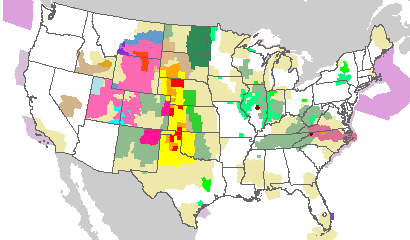
NOAA image of weather watches and warnings issued by the NOAA Storm Prediction Center as of 2:09 p.m. EDT on March 30,2007.March 30, 2007 — As a slow-moving low pressure system and associated cold front continue to move across the Central Plains, NOAA weather forecasters expect rains to continue and flooding to worsen from the Canadian border on the Red River of the North to the Rio Grande River in southern Texas. The low pressure was centered in northern Nebraska early Friday morning and is expected to strengthen Friday night before moving slowly eastward over the weekend. (Click NOAA image for larger view of weather watches and warnings issued by the NOAA Storm Prediction Center as of 2:09 p.m. EDT on March 30, 2007. Click here for latest watches and warnings. Please credit “NOAA.”)
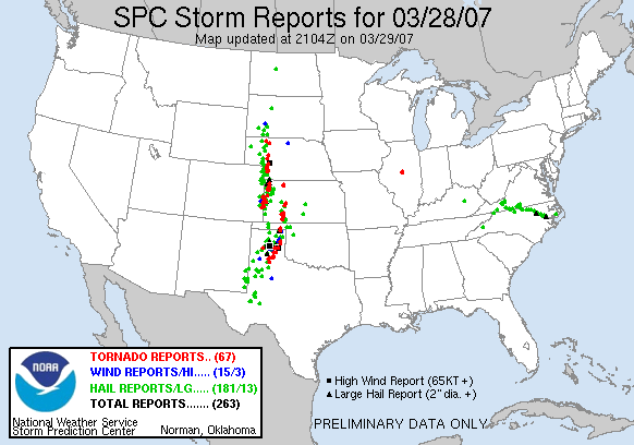
Impacting the weather to some extent in 17 central states, the storm has left more than four feet of snow in areas of Wyoming, with isolated areas of heavy snow possible Friday. The chance of tornadoes is greatly reduced Friday after the system produced up to 65 tornadoes Wednesday and four on Thursday, according to local and national forecasts. Saturated soils and the high likelihood of more rain have prompted concerns for flooding and flash flooding in 13 states from North Dakota to Texas.
“We are far from being out of the woods with this storm system, although the possibility of severe storms and tornadoes looks to be limited more to Oklahoma and Texas,” said NOAA National Weather Service Central Region Director Lynn Maximuk, “We again encourage people to pay attention to the weather and to be especially cautious of flooding and flash flooding as rain continues over a large area through the weekend.”
Quick Reaction Teams from local NOAA National Weather Service forecast offices Thursday provided preliminary intensity ratings for tornadoes in Colorado, Kansas and Nebraska.
A tornado that caused a fatality and several injuries in Holly, Colo., was rated as a high EF2 on the Enhanced Fujita intensity scale with winds of 130-135 mph. The twister was rated as possibly greater than EF3 about 15 miles north of the community. Tornadoes that hit Bird City, Kan., and Benkelman, Neb., were rated high EF2 or low EF3. The Grant, Neb., tornado was rated EF2, and the tornado that hit Ogallala, Neb., was rated EF1. Tornadoes that hit rural areas of west-central Kansas were rated EF1-EF2. The tornado that tore through Hodgeman and Ness counties in Kansas was rated EF3.
The damage survey team from NOAA’s Pueblo forecast office will return to Holly, Friday, for additional damage assessment and meetings with emergency management officials and residents.
For the third consecutive day, winter storm watches and warnings, blizzard warnings and heavy snow warnings were in effect Friday morning for portions of Montana, North Dakota, South Dakota and Wyoming. Impacted areas can, again, expect occasional white out conditions caused by high winds and blowing snow. Low snowfall amounts of 2-4 inches are expected Friday on top of snow that fell earlier in the week.
The Riverton, Wyo., weather forecast office staff recorded numerous amounts in the 12-inch to 30-inch range, with several much-more imposing amounts as well. With snow still falling, the office received reports from Fremont County of 70 inches at Hobbs Park, 53 inches at Homestead Park and 44 inches at Townsend Creek. Dome Lake in Sheridan County reported 58 inches; Cloud Peak Reservoir in Johnson County recorded 41 inches and Reno Hill in Natrona County reported 36 inches.
Even with the risk of severe weather being reduced, forecasters emphasized that the High Plains and Tornado Alley would experience rain, heavy at times, throughout the weekend. Early Friday morning, 158 flood warnings, watches or statements were in effect for weather forecast offices in 11 central plains states: Illinois, Iowa, Kansas, Minnesota, Missouri, Nebraska, North Dakota, Oklahoma, South Dakota, Texas and Wisconsin. Flood statements unrelated to this storm were in effect in Louisiana, New York and Puerto Rico.
Continued rains will worsen flooding and flash flooding problems in a north-south line stretching between the Canadian and Mexican borders, including the Red River of the North in North Dakota and Minnesota; the Mississippi River in Minnesota and the Missouri River along the Nebraska-Iowa state line into northeast Kansas and northwest Missouri.
The NOAA Paducah, Ky., weather forecast office received notice of a lightning fatality during a thunderstorm Thursday afternoon. According to the report, an 18-year-old male student died after being hit by lightning at a high school track and field complex in Carbondale, Ill.
A graphical depiction of the expected threats of severe weather, heavy snows, flooding, etc., can be found on the NOAA Hydrometeorological Prediction Center national forecast map.
NOAA, an agency of the U.S. Commerce Department, is celebrating 200 years of science and service to the nation. From the establishment of the Survey of the Coast in 1807 by Thomas Jefferson to the formation of the Weather Bureau and the Commission of Fish and Fisheries in the 1870s, much of America's scientific heritage is rooted in NOAA. NOAA is dedicated to enhancing economic security and national safety through the prediction and research of weather and climate-related events and information service delivery for transportation, and by providing environmental stewardship of the nation's coastal and marine resources. Through the emerging Global Earth Observation System of Systems (GEOSS), NOAA is working with its federal partners, more than 60 countries and the European Commission to develop a global monitoring network that is as integrated as the planet it observes, predicts and protects.
NOAA image of weather watches and warnings issued by the NOAA Storm Prediction Center as of 2:09 p.m. EDT on March 30,2007.March 30, 2007 — As a slow-moving low pressure system and associated cold front continue to move across the Central Plains, NOAA weather forecasters expect rains to continue and flooding to worsen from the Canadian border on the Red River of the North to the Rio Grande River in southern Texas. The low pressure was centered in northern Nebraska early Friday morning and is expected to strengthen Friday night before moving slowly eastward over the weekend. (Click NOAA image for larger view of weather watches and warnings issued by the NOAA Storm Prediction Center as of 2:09 p.m. EDT on March 30, 2007. Click here for latest watches and warnings. Please credit “NOAA.”)
Impacting the weather to some extent in 17 central states, the storm has left more than four feet of snow in areas of Wyoming, with isolated areas of heavy snow possible Friday. The chance of tornadoes is greatly reduced Friday after the system produced up to 65 tornadoes Wednesday and four on Thursday, according to local and national forecasts. Saturated soils and the high likelihood of more rain have prompted concerns for flooding and flash flooding in 13 states from North Dakota to Texas.
“We are far from being out of the woods with this storm system, although the possibility of severe storms and tornadoes looks to be limited more to Oklahoma and Texas,” said NOAA National Weather Service Central Region Director Lynn Maximuk, “We again encourage people to pay attention to the weather and to be especially cautious of flooding and flash flooding as rain continues over a large area through the weekend.”
Quick Reaction Teams from local NOAA National Weather Service forecast offices Thursday provided preliminary intensity ratings for tornadoes in Colorado, Kansas and Nebraska.
A tornado that caused a fatality and several injuries in Holly, Colo., was rated as a high EF2 on the Enhanced Fujita intensity scale with winds of 130-135 mph. The twister was rated as possibly greater than EF3 about 15 miles north of the community. Tornadoes that hit Bird City, Kan., and Benkelman, Neb., were rated high EF2 or low EF3. The Grant, Neb., tornado was rated EF2, and the tornado that hit Ogallala, Neb., was rated EF1. Tornadoes that hit rural areas of west-central Kansas were rated EF1-EF2. The tornado that tore through Hodgeman and Ness counties in Kansas was rated EF3.
The damage survey team from NOAA’s Pueblo forecast office will return to Holly, Friday, for additional damage assessment and meetings with emergency management officials and residents.
For the third consecutive day, winter storm watches and warnings, blizzard warnings and heavy snow warnings were in effect Friday morning for portions of Montana, North Dakota, South Dakota and Wyoming. Impacted areas can, again, expect occasional white out conditions caused by high winds and blowing snow. Low snowfall amounts of 2-4 inches are expected Friday on top of snow that fell earlier in the week.
The Riverton, Wyo., weather forecast office staff recorded numerous amounts in the 12-inch to 30-inch range, with several much-more imposing amounts as well. With snow still falling, the office received reports from Fremont County of 70 inches at Hobbs Park, 53 inches at Homestead Park and 44 inches at Townsend Creek. Dome Lake in Sheridan County reported 58 inches; Cloud Peak Reservoir in Johnson County recorded 41 inches and Reno Hill in Natrona County reported 36 inches.
Even with the risk of severe weather being reduced, forecasters emphasized that the High Plains and Tornado Alley would experience rain, heavy at times, throughout the weekend. Early Friday morning, 158 flood warnings, watches or statements were in effect for weather forecast offices in 11 central plains states: Illinois, Iowa, Kansas, Minnesota, Missouri, Nebraska, North Dakota, Oklahoma, South Dakota, Texas and Wisconsin. Flood statements unrelated to this storm were in effect in Louisiana, New York and Puerto Rico.
Continued rains will worsen flooding and flash flooding problems in a north-south line stretching between the Canadian and Mexican borders, including the Red River of the North in North Dakota and Minnesota; the Mississippi River in Minnesota and the Missouri River along the Nebraska-Iowa state line into northeast Kansas and northwest Missouri.
The NOAA Paducah, Ky., weather forecast office received notice of a lightning fatality during a thunderstorm Thursday afternoon. According to the report, an 18-year-old male student died after being hit by lightning at a high school track and field complex in Carbondale, Ill.
A graphical depiction of the expected threats of severe weather, heavy snows, flooding, etc., can be found on the NOAA Hydrometeorological Prediction Center national forecast map.
NOAA, an agency of the U.S. Commerce Department, is celebrating 200 years of science and service to the nation. From the establishment of the Survey of the Coast in 1807 by Thomas Jefferson to the formation of the Weather Bureau and the Commission of Fish and Fisheries in the 1870s, much of America's scientific heritage is rooted in NOAA. NOAA is dedicated to enhancing economic security and national safety through the prediction and research of weather and climate-related events and information service delivery for transportation, and by providing environmental stewardship of the nation's coastal and marine resources. Through the emerging Global Earth Observation System of Systems (GEOSS), NOAA is working with its federal partners, more than 60 countries and the European Commission to develop a global monitoring network that is as integrated as the planet it observes, predicts and protects.
0 likes
Return to “USA & Caribbean Weather”
Who is online
Users browsing this forum: Brushcountry, Google [Bot], txtwister78 and 54 guests