
SE TX/SW LA Discussion Thread - Mid 80's and sunny this week
Moderator: S2k Moderators
Forum rules

The posts in this forum are NOT official forecast and should not be used as such. They are just the opinion of the poster and may or may not be backed by sound meteorological data. They are NOT endorsed by any professional institution or STORM2K.
-
Yankeegirl

- Category 5

- Posts: 3417
- Age: 50
- Joined: Sun May 23, 2004 11:59 pm
- Location: Cy-Fair, Northwest Houston
- Contact:
-
jasons2k

- Storm2k Executive

- Posts: 8290
- Age: 52
- Joined: Wed Jul 06, 2005 12:32 pm
- Location: The Woodlands, TX
This is from earlier, but....
http://www.spc.noaa.gov/products/md/md0393.html
MESOSCALE DISCUSSION 0393
NWS STORM PREDICTION CENTER NORMAN OK
0530 AM CDT SAT MAR 31 2007
AREAS AFFECTED...SOUTHEAST TX
CONCERNING...TORNADO WATCH 98...
VALID 311030Z - 311230Z
...SEVERE WEATHER THREAT CONTINUES WITHIN VALID PORTIONS OF TORNADO
WATCH 98...
MATURE MCS WITH THREE DISTINCT BOWING LINE SEGMENTS CONTINUE MOVING
EAST ACROSS TORNADO WATCH 98. EACH BOWING SEGMENT APPEARS TO BE TIED
TO WELL-DEFINED AND LONG-LIVED MESOCYCLONES. SEVERAL TORNADO REPORTS
HAVE OCCURRED WITH THE MOST INTENSE AND ORGANIZED MESOCYCLONE AS IT
CROSSED LAVACA COUNTY OVER THE PAST HOUR. THIS COMPLEX IS CURRENTLY
MOVING ACROSS NRN WHARTON COUNTY AND WILL REACH THE SRN PORTIONS OF
THE HOUSTON METRO AREA IN ABOUT AN HOUR.
GIVEN CURRENT STORM CHARACTERISTICS AND ENVIRONMENT ACROSS THE WATCH
CHARACTERIZED BY WARM/MOIST AIR MASS SUPPORTING LOW LFC AND HIGH LOW
LEVEL SHEAR...WIND DAMAGE AND TORNADO POTENTIAL REMAIN QUITE HIGH
EARLY THIS MORNING.
0 likes

-
Yankeegirl
- Category 5
- Posts: 3417
- Age: 50
- Joined: Sun May 23, 2004 11:59 pm
- Location: Cy-Fair, Northwest Houston
- Contact:
-
Yankeegirl
- Category 5
- Posts: 3417
- Age: 50
- Joined: Sun May 23, 2004 11:59 pm
- Location: Cy-Fair, Northwest Houston
- Contact:
-
Yankeegirl
- Category 5
- Posts: 3417
- Age: 50
- Joined: Sun May 23, 2004 11:59 pm
- Location: Cy-Fair, Northwest Houston
- Contact:

-
vbhoutex

- Storm2k Executive
- Posts: 29149
- Age: 74
- Joined: Wed Oct 09, 2002 11:31 pm
- Location: Cypress, TX
- Contact:
Started out with a heck of a "gust front" and lightening display here with torrential rain, but that blew through quickly. Soiunded severe, but I don't imagine we had naything to severe levels. Gusts may have reached the 40 mph range. Now it is just a little raiin with thunder in the distance. Lost power 3 times, but obviously it is back now too. Back to bed.
Just checked the weatherbug closest to me and we gusted to 53 mph.
Just checked the weatherbug closest to me and we gusted to 53 mph.
0 likes

-
southerngale

- Retired Staff

- Posts: 27418
- Joined: Thu Oct 10, 2002 1:27 am
- Location: Southeast Texas (Beaumont area)
It's storming pretty good right now. Thunder woke me up a little while ago.
Severe Thunderstorm Warning
SEVERE WEATHER STATEMENT
NATIONAL WEATHER SERVICE LAKE CHARLES LA
900 AM CDT SAT MAR 31 2007
TXC245-361-311445-
/O.CON.KLCH.SV.W.0016.000000T0000Z-070331T1445Z/
JEFFERSON TX-ORANGE TX-
900 AM CDT SAT MAR 31 2007
...A SEVERE THUNDERSTORM WARNING CONTINUES UNTIL 945 AM CDT FOR
ORANGE AND JEFFERSON COUNTIES...
AT 859 AM CDT...NATIONAL WEATHER SERVICE DOPPLER RADAR CONTINUED TO
INDICATE A LINE OF SEVERE THUNDERSTORMS CAPABLE OF PRODUCING
DESTRUCTIVE WINDS IN EXCESS OF 70 MPH. THESE STORMS WERE LOCATED
ALONG A LINE EXTENDING FROM PINE FOREST TO 5 MILES NORTHWEST OF
BRIDGE CITY TO 10 MILES SOUTHWEST OF PORT ARTHUR..MOVING EAST AT 35
MPH.
THIS LINE OF SEVERE THUNDERSTORMS WILL BE NEAR...
PORT ARTHUR AND GROVES BY 905 AM CDT
BRIDGE CITY BY 910 AM CDT
MAURICEVILLE AND WEST ORANGE BY 915 AM CDT
ORANGE BY 920 AM CDT
A WIND GUST TO 69 MPH WAS REPORTED IN SOUTHEAST BEAUMONT AT LAMAR
UNIVERSITY WITH THIS LINE OF STORMS. THESE ARE DANGEROUS
STORMS...SEEK SAFE SHELTER AND STAY AWAY FROM WINDOWS!
A SEVERE THUNDERSTORM WATCH REMAINS IN EFFECT UNTIL 200 PM CDT
SATURDAY AFTERNOON FOR SOUTHWESTERN LOUISIANA AND SOUTHEAST TEXAS.
LAT...LON 3016 9409 3018 9421 2980 9407 2982 9397
2998 9385 3007 9373 3024 9373 3023 9408
$$
SHAMBURGER
0 likes

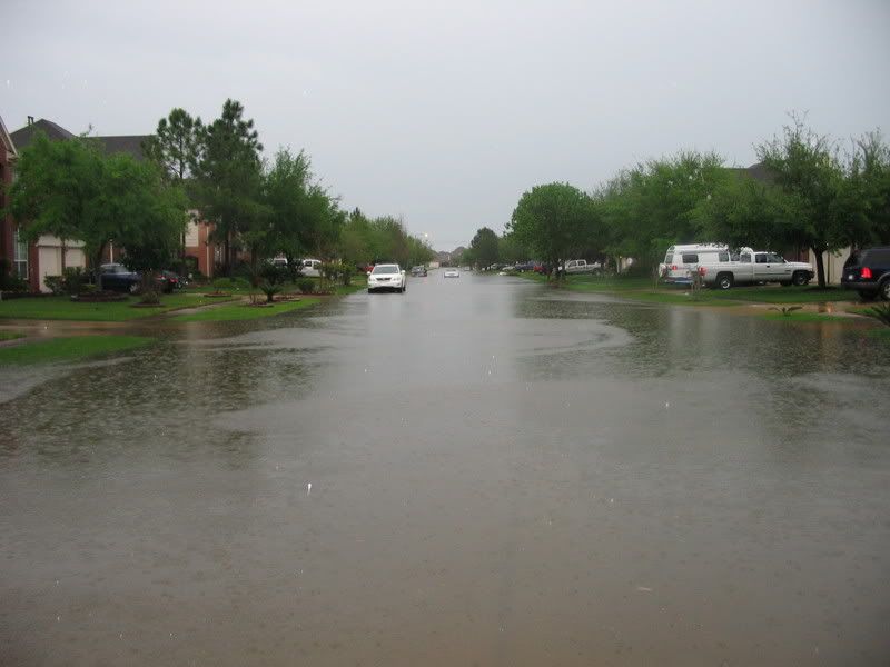
We have gotten a deluge this morning. Setting at 4.38", the streets are flooded over the curb and some sidewalks. The creek behind my house almost to the top. Thank goodness the rain is finally slcking off.
0 likes
The following post is NOT an official forecast and should not be used as such. It is just the opinion of the poster and may or may not be backed by sound meteorological data. It is NOT endorsed by any professional institution including storm2k.org For Official Information please refer to the NHC and NWS products.
Here are some images to share after 4.56" of rain fell this morning.


0 likes
The following post is NOT an official forecast and should not be used as such. It is just the opinion of the poster and may or may not be backed by sound meteorological data. It is NOT endorsed by any professional institution including storm2k.org For Official Information please refer to the NHC and NWS products.
-
Extremeweatherguy

- Category 5
- Posts: 11095
- Joined: Mon Oct 10, 2005 8:13 pm
- Location: Florida
The last time I saw our streets flood to this magnitude was Allison. It just goes to show what training can bring.
0 likes
The following post is NOT an official forecast and should not be used as such. It is just the opinion of the poster and may or may not be backed by sound meteorological data. It is NOT endorsed by any professional institution including storm2k.org For Official Information please refer to the NHC and NWS products.


-
vbhoutex
- Storm2k Executive
- Posts: 29149
- Age: 74
- Joined: Wed Oct 09, 2002 11:31 pm
- Location: Cypress, TX
- Contact:
WOW!!! We didn't get anything near 4.56" of rain. I still haven't checked the guage, but it looks like it is over 2" from where I can look at it without going out in the rain that is still falling here. Didn't see any street flooding. We have a lot of little twigs and smaller limbs down in the area, so I guess the winds did make it up to the 50 mph range. Probably some small hail too from the looks of the debris from the trees and how it is distributed. Jason, sorry about that roof. Now you have to grow some more palms to cover it!! 
After the initial storm hit and things settled down(lost power 3 times during it)it was great sleeping weather till 10 am!!!!
After the initial storm hit and things settled down(lost power 3 times during it)it was great sleeping weather till 10 am!!!!
0 likes
Return to “USA & Caribbean Weather”
Who is online
Users browsing this forum: No registered users and 83 guests