ENSO Updates (2007 thru 2023)
Moderator: S2k Moderators
Forum rules

The posts in this forum are NOT official forecasts and should not be used as such. They are just the opinion of the poster and may or may not be backed by sound meteorological data. They are NOT endorsed by any professional institution or STORM2K. For official information, please refer to products from the National Hurricane Center and National Weather Service.


-
x-y-no

- Category 5

- Posts: 8359
- Age: 65
- Joined: Wed Aug 11, 2004 12:14 pm
- Location: Fort Lauderdale, FL
Ivanhater wrote:If I remember , 2005 was a neutral year, so we dont need a full blown la nina to have one heck of a season and 2004 actually went into a weak el nino near the end of the season
Yes. In fact, for most of the 2005 season Nino 3,4 was about half a degree warm - still neutral but on the warm side.
As far as I'm aware, there's little difference between neutral and La Nina as far as the Atlantic season goes. It does have some impact on the EPAC season.
0 likes
-
SouthFloridawx

- S2K Supporter

- Posts: 8346
- Age: 47
- Joined: Tue Jul 26, 2005 1:16 am
- Location: Sarasota, FL
- Contact:
-
AussieMark

- Category 5
- Posts: 5857
- Joined: Tue Sep 02, 2003 6:36 pm
- Location: near Sydney, Australia
-
wxman57

- Moderator-Pro Met

- Posts: 23173
- Age: 68
- Joined: Sat Jun 21, 2003 8:06 pm
- Location: Houston, TX (southwest)
Latest analysis/forecast is for a significant La Nina during July-August-September-October of 2007, in the range of -1.0 to -1.5. Regions 3-4 are now slightly cooler than normal and decreasing.

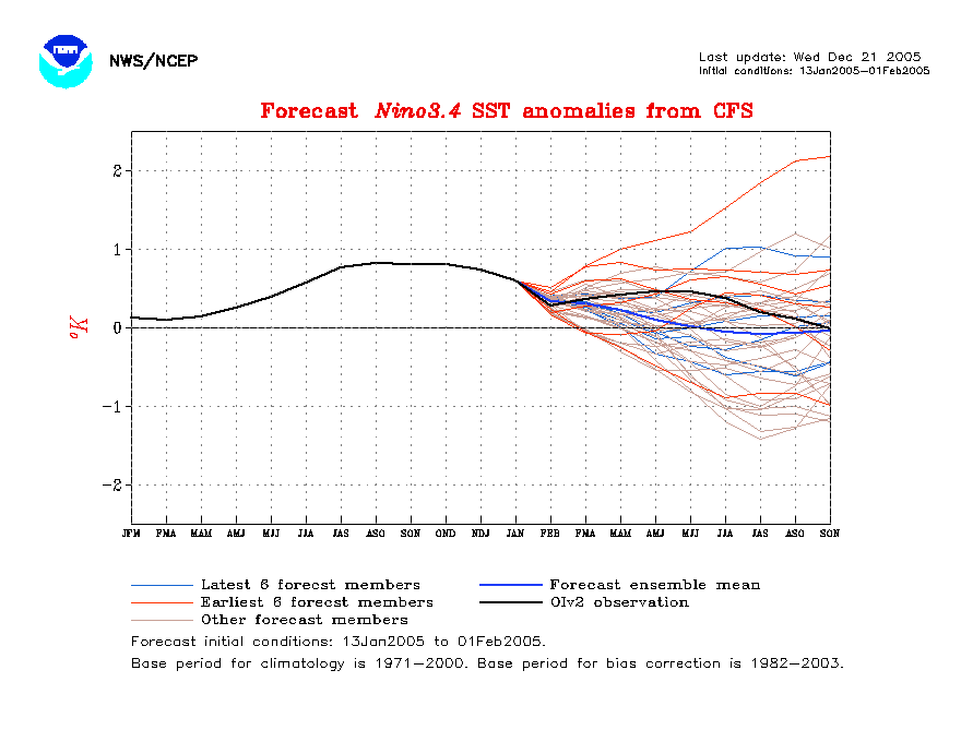
And for those of you asking abour region 3.4 during 2005, here's the archived image:
 [sup]
[sup]
And for those of you asking abour region 3.4 during 2005, here's the archived image:
[sup]
Last edited by wxman57 on Sun Apr 01, 2007 9:46 am, edited 1 time in total.
0 likes

-
P.K.

- Professional-Met

- Posts: 5149
- Joined: Thu Sep 23, 2004 5:57 pm
- Location: Watford, England
- Contact:
AussieMark wrote:La Nina is still off
there has not been a single week where Nino 3.4 was in negatives yet.
and when it happens we need a 3 monthly average of -0.5 to be classed as La Nina
Nino 3 dropped to -0.12C for a week in early March but rose back into positive figures after that. Nino 3.4 and 4 are still positive as you say to 25/3.
0 likes
-
cycloneye

- Admin

- Posts: 149395
- Age: 69
- Joined: Thu Oct 10, 2002 10:54 am
- Location: San Juan, Puerto Rico

The subsurface waters continue to be cool at El Nino 1-2 and 3 but more warm at El Nino 3-4.
0 likes
Visit the Caribbean-Central America Weather Thread where you can find at first post web cams,radars
and observations from Caribbean basin members Click Here
and observations from Caribbean basin members Click Here

-
cycloneye
- Admin
- Posts: 149395
- Age: 69
- Joined: Thu Oct 10, 2002 10:54 am
- Location: San Juan, Puerto Rico

Here is the latest anomalies graphic of the Pacific and surely those cool waters at El Nino 1-2 and 3 are la Ninalike ones.But still west of that ,at El Nino 3-4 area not so cool waters prevail.
0 likes
Visit the Caribbean-Central America Weather Thread where you can find at first post web cams,radars
and observations from Caribbean basin members Click Here
and observations from Caribbean basin members Click Here
-
cycloneye
- Admin
- Posts: 149395
- Age: 69
- Joined: Thu Oct 10, 2002 10:54 am
- Location: San Juan, Puerto Rico
CPC (Climate Prediction Center) April Update
The pattern of anomalous sea surface temperatures (SSTs) during March 2007 was consistent with ENSO-neutral conditions in the tropical Pacific, with average to slightly below-average SSTs extending from the date line to the west coast of South America (Fig. 1). The latest weekly SST departures are near 0ºC in the Niño 3.4 region, and below -0.5ºC in the Niño 3 and Niño 1+2 regions (Fig. 2). An area of anomalously warm SSTs persisted well west of the date line (near 165ºE), and an area of SSTs exceeding 30°C was centered between 150°E and 165°E.
Here is the April ENSO update from CPC.Above is a paragrafh of the update.Read all the details at link above.
0 likes
Visit the Caribbean-Central America Weather Thread where you can find at first post web cams,radars
and observations from Caribbean basin members Click Here
and observations from Caribbean basin members Click Here
-
Hybridstorm_November2001

- S2K Supporter
- Posts: 2817
- Joined: Sat Aug 21, 2004 2:50 pm
- Location: SW New Brunswick, Canada
- Contact:
This is not good from my POV. Every time Eastern New England and Western New Brunswick (usually hit after the first landfall around Cape Cod) has suffered a major hurricane hit in the past, it has been during a La Nina year (1954 with Carol and Edna springs at once to mind, as the last real major two storms). I'm rather worried now.
0 likes
-
Hybridstorm_November2001
- S2K Supporter
- Posts: 2817
- Joined: Sat Aug 21, 2004 2:50 pm
- Location: SW New Brunswick, Canada
- Contact:
Strange I personally always counted on my maternal Grandmother's knowledge to pull me through any storm; she lived in the area for over 60 years. She died this winter. She told my stories about how bad Carol and Edna were, especially Edna. She claimed you could not imagine how bad it was it you hadn't went through it, and that no storms she could remember (winter or summer) could compare. How ironic it would be if the same thing happened this year, now that I don't have her memories to help me prepare.
Pardon my musings, just struck at cord.
Pardon my musings, just struck at cord.
0 likes
-
HouTXmetro

- Category 5
- Posts: 3949
- Joined: Sun Jun 13, 2004 6:00 pm
- Location: District of Columbia, USA
HURAKAN wrote:Everything seems to indicate we will have an active season. Now it's the time to get ready, so nothing will be a surprise in August, September, or October.
don't forget June and July
0 likes
[Disclaimer: My Amateur Opinion, please defer to your local authorities or the NHC for Guidance.]
-
cycloneye
- Admin
- Posts: 149395
- Age: 69
- Joined: Thu Oct 10, 2002 10:54 am
- Location: San Juan, Puerto Rico
HouTXmetro wrote:HURAKAN wrote:Everything seems to indicate we will have an active season. Now it's the time to get ready, so nothing will be a surprise in August, September, or October.
don't forget June and July
He may be reffering to the most active part of the season.
0 likes
Visit the Caribbean-Central America Weather Thread where you can find at first post web cams,radars
and observations from Caribbean basin members Click Here
and observations from Caribbean basin members Click Here
-
HURAKAN

- Professional-Met
- Posts: 46084
- Age: 39
- Joined: Thu May 20, 2004 4:34 pm
- Location: Key West, FL
- Contact:
HouTXmetro wrote:HURAKAN wrote:Everything seems to indicate we will have an active season. Now it's the time to get ready, so nothing will be a surprise in August, September, or October.
don't forget June and July
I know, but June and July usually don't bring strong cyclones, except for 2005!!!
0 likes
-
P.K.
- Professional-Met
- Posts: 5149
- Joined: Thu Sep 23, 2004 5:57 pm
- Location: Watford, England
- Contact:
cycloneye wrote:The latest weekly SST departures are near 0ºC in the Niño 3.4 region, and below -0.5ºC in the Niño 3 and Niño 1+2 regions (Fig. 2)
Agree with the Nino 3.4 value (BoM have it at +0.14C for the week 26/3/2007 to 1/4/2007), but I'm not sure where they are getting -0.5C from for Nino 3 as the BoM only have it at -0.11C for the same week as the previous value. That is quite a big difference there so one of them must be a little way out.
Latest Nino 1 ave is +0.55C with Nino 2 at -0.89C, maybe they've averagd over both regions there.
0 likes
-
Blown Away

- S2K Supporter
- Posts: 10253
- Joined: Wed May 26, 2004 6:17 am
-
AussieMark
- Category 5
- Posts: 5857
- Joined: Tue Sep 02, 2003 6:36 pm
- Location: near Sydney, Australia
Who is online
Users browsing this forum: Kingarabian and 34 guests