The posts in this forum are NOT official forecast and should not be used as such. They are just the opinion of the poster and may or may not be backed by sound meteorological data. They are NOT endorsed by any professional institution or

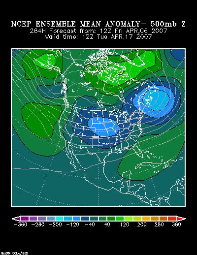
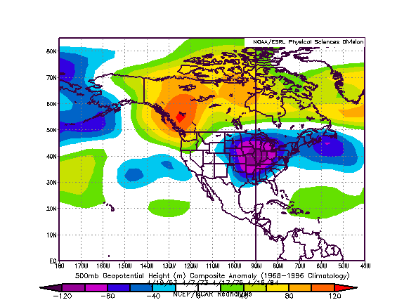
NCEP 500 mb Mean 500 mb Anomalies at 264 hours:
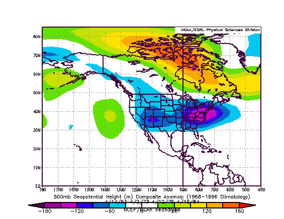
Composite Historic 500 mb Anomalies:
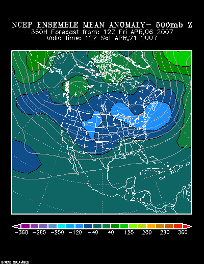
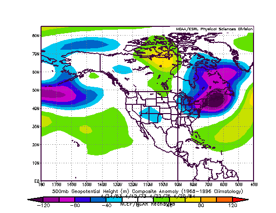
NCEP 500 mb Mean 500 mb Anomalies at 360 hours:
Composite Historic 500 mb Anomalies adjusted forward by 120 hours from those posted above:
Composite Historic 500 mb Anomalies adjusted forward by 240 hours from those posted at the beginning of this discussion:
If the historic experience holds true, the April 16-23 period could wind up cooler than normal and also wetter than normal in the Great Lakes, Mid-Atlantic, and Northeast regions. Springlike warmth might not begin to return there, at earliest, until perhaps closing 3-5 days of April.
My thinking for the average temperature anomalies during the 4/16-23 period is as follows:
Average Regional Temperature Anomalies (4/16-23):
Northeast: Much below normal to below normal
Mid-Atlantic: Below normal
Southeast: Somewhat normal
Great Lakes: Much below normal to below normal
Northern Plains: Below normal
Central Plains: Below normal
Southern Plains: Below normal
Pacific Northwest: Somewhat below normal to near normal
Southwest/Rest of West Coast: Somewhat above normal
For the major cities from Washington, DC to Boston, the 4/16-23 period is likely to feature:
- Nights generally in the 30s in Boston and 30s and 40s in New York City, Philadelphia, and Washington, DC.
- Days mainly in the 50s in Boston and 50s and 60s in New York City, Philadelphia and Washington, DC.
- Boston could see a day with a high temperature below 50°
In the Southeast, Atlanta will likely see highs generally in the 60s and 70s. Lows should generally be in the 40s and 50s. Elsewhere, Burlington will likely see highs mainly in the 40s and 50s. Lows should be mainly in the 30s. A subfreezing night is possible.
Toronto: Most days will likely see highs in the 7.0°C to 14.0°C range (mid 40s to mid 50s). Nights will generally be in the +1.0°C to +7.0°C range (30s to lower 40s). The low temperature could fall below freezing on one or two days.
Occasional Historic Tidbit:
On April 22-23, 1993, a storm that moved from the Delmarva Peninsula into eastern New England brought heavy wet snow to portions of New York State. 22 inches fell at Malone. Binghamton picked up 10.3 inches.