The posts in this forum are NOT official forecast and should not be used as such. They are just the opinion of the poster and may or may not be backed by sound meteorological data. They are NOT endorsed by any professional institution or

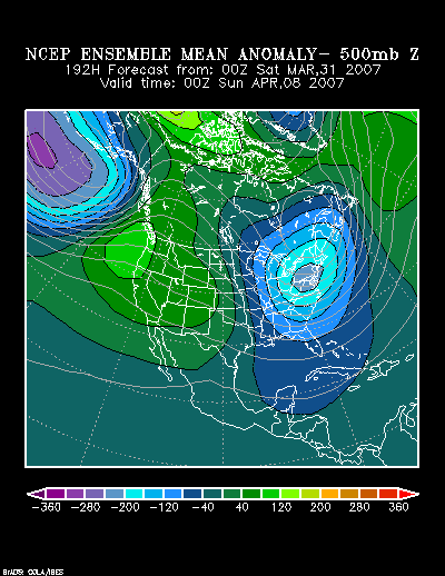
From 3/31 0z:
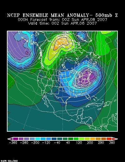
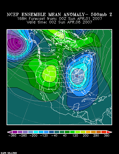
From 4/1 0z:
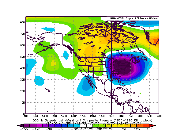
Since 1950, there have been six occasions in which reasonably similar 500 mb patterns have occurred during the 4/1-15 timeframe. The composite 500 mb anomalies were as follows:
The lowest temperature for the cold outbreaks from the composite 500 mb patterns for select cities were as follows:
April 13-15, 1950:
Boston: 34°
Burlington: 27°
Montreal: 27° (-2.8°C)
New York City: 26°
Philadelphia: 24°
Toronto: 16° (-8.9°C)
Washington, DC (DCA): 24°
April 1-4, 1966:
Boston: 34°
Burlington: 25°
Montreal: 26° (-3.3°C)
New York City: 34°
Philadelphia: 31°
Toronto: 21° (-6.1°C)
Washington, DC (DCA): 35°
April 11-14, 1973:
Boston: 31°
Burlington: 17°
Montreal: 16° (-8.9°C)
New York City: 33°
Philadelphia: 29°
Toronto: 18° (-7.8°C)
Washington, DC (DCA): 32°
April 3-6, 1975:
Boston: 32°
Burlington: 26°
Montreal: 26° (-3.3°C)
New York City: 27°
Philadelphia: 26°
Toronto: 15° (-9.4°C)
Washington, DC (DCA): 33°
April 2-6, 1992:
Boston: 33°
Burlington: 29°
Montreal: 25° (-3.9°C)
New York City: 33°
Philadelphia: 30°
Toronto: 24° (-4.5°C)
Washington, DC (DCA): 31°
April 4-6, 2004:
Boston: 30°
Burlington: 19°
Montreal: 16° (-9.0°C)
New York City: 30°
Philadelphia: 31°
Toronto: 20° (-6.6°C)
Washington, DC (DCA): 31°
Taking all the factors—historic, synoptic, and modeled—into consideration, I believe Boston, New York City, Philadelphia, and Washington, DC will all see one or more days with a low temperature of 32° or below. Philadelphia and Washington, DC have a good chance to a low temperature < 30°. Burlington should see a low temperature of 27° or colder and Montreal should have a low temperature of 26° (-3.3°C) or colder. Toronto's coldest temperature will probably come to 23° (-5.0°C) or colder and a low < 20° (-6.7°C) is a possibility.
Finally, at this time, it is still a close call whether a system will move off the Mid-Atlantic coast and head northeastward. If such a situation occurs, odds favor an area running from southern New Jersey across Long Island and then the eastern third of New England to see the most meaningful precipitation. The best chance for some accumulating snow would exist across eastern Connecticut, Rhode Island, eastern Massachusetts and northward. There, the potential might exist for several inches, but such a storm, much less snowfall is not assured at this time.