 The posts in this forum are NOT official forecast and should not be used as such. They are just the opinion of the poster and may or may not be backed by sound meteorological data. They are NOT endorsed by any professional institution or

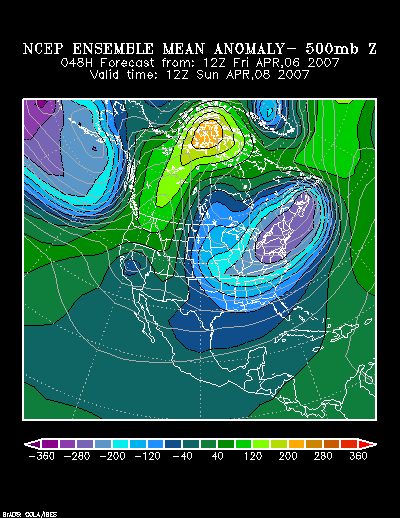
NCEP Ensemble Mean 500 mb Anomalies at 48 hours:
March 30, 1964 500 mb Anomalies:

Taking into consideration the 1964 event and the computer guidance, I believe it is likely that some part of the Mid-Atlantic region could pick up 3"-6" of snow with locally higher amounts. Considering that much of the precipitation is likely to fall within a 6-hour period, dynamic cooling should ensure a mostly or wholly snow event for Washington, DC and northward. The appreciable or greater snows will probably fall across Baltimore, Salisbury, Washington, DC and Wilmington. Daily snowfall records should be challenged or broken in the Baltimore and Washington, DC areas.
Daily snowfall records for April 7:
Baltimore: 0.2", 1972
Washington, DC:
...DCA: 0.6", 1972
...IAD: 1.1", 1990
Lesser amounts could whiten the ground in Philadelphia and Atlantic City. Flurries or a burst of non-accumulating snow could occur even farther north.
At this time, my initial estimates are as follows:
Atlantic City: 0.5"-1.5"
Baltimore: 2"-5"
Philadelphia: 0.5"-1.5"
Richmond: 1" or less
Salisbury: 2"-5"
Washington, DC: DCA: 1"-3"; IAD: 1"-3"
Wilmington: 2"-5"

