Severe Storms Tampa Bay Area-Hail, Damaging Winds
Moderator: S2k Moderators
Forum rules

The posts in this forum are NOT official forecast and should not be used as such. They are just the opinion of the poster and may or may not be backed by sound meteorological data. They are NOT endorsed by any professional institution or STORM2K.
-
JonathanBelles
- Professional-Met

- Posts: 11430
- Age: 35
- Joined: Sat Dec 24, 2005 9:00 pm
- Location: School: Florida State University (Tallahassee, FL) Home: St. Petersburg, Florida
- Contact:
-
JonathanBelles
- Professional-Met
- Posts: 11430
- Age: 35
- Joined: Sat Dec 24, 2005 9:00 pm
- Location: School: Florida State University (Tallahassee, FL) Home: St. Petersburg, Florida
- Contact:
-
JonathanBelles
- Professional-Met
- Posts: 11430
- Age: 35
- Joined: Sat Dec 24, 2005 9:00 pm
- Location: School: Florida State University (Tallahassee, FL) Home: St. Petersburg, Florida
- Contact:
-
Cookiely

- S2K Supporter

- Posts: 3211
- Age: 75
- Joined: Fri Aug 13, 2004 7:31 am
- Location: Tampa, Florida
Severe Thunderstorm Warning
879 WUUS1 KTBW 120208 WSI PPS:120209 SVRTBW FLC057-120240- /O.NEW.KTBW.SV.W.0014.070412T0206Z-070412T0240Z/ BULLETIN - EAS ACTIVATION REQUESTED SEVERE THUNDERSTORM WARNING NATIONAL WEATHER SERVICE TAMPA BAY AREA - RUSKIN FL 1006 PM EDT WED APR 11 2007
THE NATIONAL WEATHER SERVICE IN RUSKIN HAS ISSUED A * SEVERE THUNDERSTORM WARNING FOR... CENTRAL HILLSBOROUGH COUNTY IN FLORIDA. * UNTIL 1040 PM EDT * AT 1006 PM EDT...NATIONAL WEATHER SERVICE DOPPLER RADAR INDICATED A SEVERE THUNDERSTORM...CAPABLE OF PRODUCING PENNY SIZE HAIL AND DAMAGING 60 MPH WINDS...OVER TEMPLE TERRACE...MOVING EAST AT 35 MPH. * THE SEVERE THUNDERSTORM WILL BE NEAR... MANGO. BRANDON. SEFFNER. PLANT CITY. MOVE INSIDE A STURDY BUILDING. DAMAGING WIND...LARGE HAIL... TORRENTIAL RAIN...AND DEADLY LIGHTNING ARE EXPECTED. STAY INSIDE AWAY FROM WINDOWS UNTIL THE STORM HAS PASSED. FREQUENT CLOUD TO GROUND LIGHTNING IS OCCURRING WITH THIS STORM. DO NOT USE ELECTRICAL APPLIANCES OR TELEPHONES. QUARTER SIZE HAIL IS LIKELY. MOVE INDOORS IMMEDIATELY. PLEASE REPORT TORNADOES OR FUNNEL CLOUDS...WINDS OF 58 MPH OR HIGHER...HAIL THE SIZE OF PENNIES OF LARGER...AND ANY WIND DAMAGE TO YOUR NATIONAL WEATHER SERVICE IN RUSKIN BY CALLING 813-645-2323. && LAT...LON 2810 8241 2789 8239 2789 8209 2815 8212 $$ 22
0 likes


-
HurricaneHunter914
- Category 5

- Posts: 4439
- Age: 32
- Joined: Fri Mar 10, 2006 7:36 pm
- Location: College Station, TX
Seems really heavy. Florida's really geeting the meaning of April Showers. 
0 likes
Personal Forecast Disclaimer:
The posts in this forum are NOT official forecast and should not be used as such. They are just the opinion of the poster and may or may not be backed by sound meteorological data. They are NOT endorsed by any professional institution or storm2k.org. For official information, please refer to the NHC and NWS products.
The posts in this forum are NOT official forecast and should not be used as such. They are just the opinion of the poster and may or may not be backed by sound meteorological data. They are NOT endorsed by any professional institution or storm2k.org. For official information, please refer to the NHC and NWS products.
-
JonathanBelles
- Professional-Met
- Posts: 11430
- Age: 35
- Joined: Sat Dec 24, 2005 9:00 pm
- Location: School: Florida State University (Tallahassee, FL) Home: St. Petersburg, Florida
- Contact:
AT 1043 PM EDT...AN AMATEUR RADIO OPERATOR REPORTED NICKEL SIZED
HAIL IN LAKELAND NORTH OF INTERSTATE 4.
This is from the same storms in E. Hillsborough earlier.. definately these storms have a severe history. They are moving into the Winter Haven area now.
The heavy storms missed Pinellas and most of the city of Tampa... better luck next time!!!
HAIL IN LAKELAND NORTH OF INTERSTATE 4.
This is from the same storms in E. Hillsborough earlier.. definately these storms have a severe history. They are moving into the Winter Haven area now.
The heavy storms missed Pinellas and most of the city of Tampa... better luck next time!!!
0 likes
-
JonathanBelles
- Professional-Met
- Posts: 11430
- Age: 35
- Joined: Sat Dec 24, 2005 9:00 pm
- Location: School: Florida State University (Tallahassee, FL) Home: St. Petersburg, Florida
- Contact:
Here's the forecast discussion from Tampa earlier this afternoon. WOW THEY BLEW THAT FORECAST, HUH?
AREA FORECAST DISCUSSION
NATIONAL WEATHER SERVICE TAMPA BAY RUSKIN FL
115 PM EDT WED APR 11 2007
SHORT TERM (TONIGHT - FRIDAY): MODELS IN FAIRLY GOOD AGREEMENT
THROUGH THE PERIOD WITH AN UPPER LOW OVER THE MIDWEST/ WITH SW
FLOW ALOFT THE CWFA/ TRACKING ACROSS THE EASTERN GREAT LAKES AND
INTO CANADIAN MARITIMES...ALLOWING WEAK UPPER RIDGING TO BUILD
OVER FL. A WEAK FRONTAL BOUNDARY EXTENDING SOUTH FROM A SURFACE
REFLECTION OF THE UPPER LOW MOVES ACROSS THE GULF TONIGHT AND THEN
DOWN THE STATE THU...REACHING SOUTH FL THU NIGHT. LIMITED MOISTURE
AND ENERGY WITH THIS BOUNDARY WILL KEEP THIS A DRY FRONTAL PASSAGE.
THE ISOLATED PCPN THIS EVENING WILL BE JUST LEFT OVER FROM THIS
AFTERNOON. SURFACE HIGH PRESSURE BUILDING FROM THE NORTHERN PLAINS
TO THE CENTRAL GULF THU WILL SLIDE EASTWARD.....
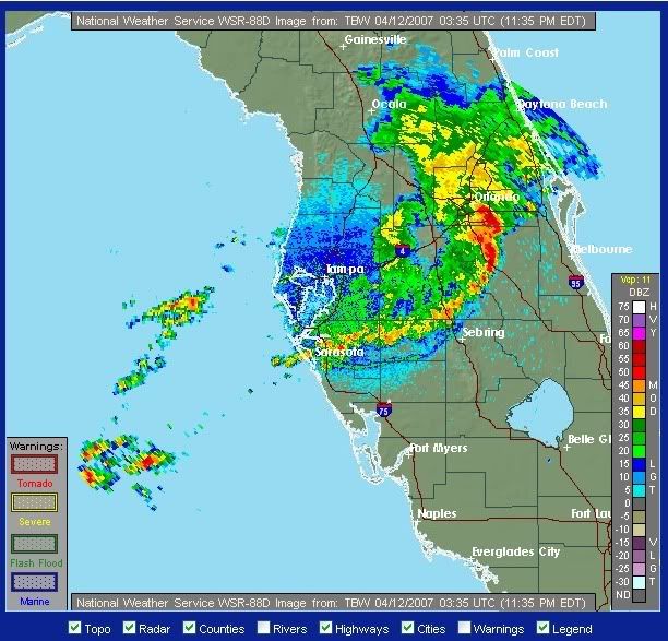
Nice looking bow echo moving toward the east cost now... with 64mph winds reported earlier in Lakeland
AREA FORECAST DISCUSSION
NATIONAL WEATHER SERVICE TAMPA BAY RUSKIN FL
115 PM EDT WED APR 11 2007
SHORT TERM (TONIGHT - FRIDAY): MODELS IN FAIRLY GOOD AGREEMENT
THROUGH THE PERIOD WITH AN UPPER LOW OVER THE MIDWEST/ WITH SW
FLOW ALOFT THE CWFA/ TRACKING ACROSS THE EASTERN GREAT LAKES AND
INTO CANADIAN MARITIMES...ALLOWING WEAK UPPER RIDGING TO BUILD
OVER FL. A WEAK FRONTAL BOUNDARY EXTENDING SOUTH FROM A SURFACE
REFLECTION OF THE UPPER LOW MOVES ACROSS THE GULF TONIGHT AND THEN
DOWN THE STATE THU...REACHING SOUTH FL THU NIGHT. LIMITED MOISTURE
AND ENERGY WITH THIS BOUNDARY WILL KEEP THIS A DRY FRONTAL PASSAGE.
THE ISOLATED PCPN THIS EVENING WILL BE JUST LEFT OVER FROM THIS
AFTERNOON. SURFACE HIGH PRESSURE BUILDING FROM THE NORTHERN PLAINS
TO THE CENTRAL GULF THU WILL SLIDE EASTWARD.....
Nice looking bow echo moving toward the east cost now... with 64mph winds reported earlier in Lakeland
0 likes
-
Tampa Bay Hurricane

- Category 5
- Posts: 5597
- Age: 38
- Joined: Fri Jul 22, 2005 7:54 pm
- Location: St. Petersburg, FL
-
Tampa Bay Hurricane
- Category 5
- Posts: 5597
- Age: 38
- Joined: Fri Jul 22, 2005 7:54 pm
- Location: St. Petersburg, FL
Tampa Bay Hurricane wrote:It was very windy for about 20 minutes last night with those storms. I would say gusts of 45 mph with twigs and a couple branches down.
Highest gust I saw in our area was 36 mph at Tampa Int'l
TPA History
Do you have a weather station? I was trying to measure the winds with a handheld anemometer but I was geting soaked so I stopped.
0 likes
-
Tampa Bay Hurricane
- Category 5
- Posts: 5597
- Age: 38
- Joined: Fri Jul 22, 2005 7:54 pm
- Location: St. Petersburg, FL
tbstorm wrote:Tampa Bay Hurricane wrote:It was very windy for about 20 minutes last night with those storms. I would say gusts of 45 mph with twigs and a couple branches down.
Highest gust I saw in our area was 36 mph at Tampa Int'l
TPA History
Do you have a weather station? I was trying to measure the winds with a handheld anemometer but I was geting soaked so I stopped.
No I don't have a working anemometer. I estimated 45 mph based on the what I saw and some tree branches down...it looked really strong for some time...but it may have been 35 mph because my eyes aren't that great.
But the winds honesty looked and sounded almost like what they were during Tropical Storm Frances in 2004 but not as strong but for a few minutes,
very close to Frances, because the trees were swaying really, really hard for a short time, I was under a sheltered part of my balcony watching.
0 likes
Return to “USA & Caribbean Weather”
Who is online
Users browsing this forum: opticsguy, txtwister78 and 89 guests