Post your thoughts. Or if you're in it's path (raises hand) post conditions here.
25 foot seas and tides 7 feet above normal forecasted along the Jersey shore.
Right now here, it's overcast, about 53 degrees, pressure at 1011mb. The wind is absolutely still.
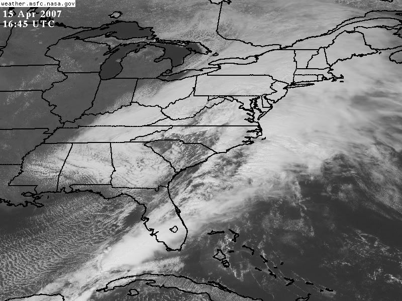
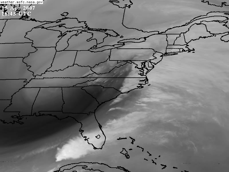
Noreaster 4/15-16 2007
Moderator: S2k Moderators
Forum rules

The posts in this forum are NOT official forecast and should not be used as such. They are just the opinion of the poster and may or may not be backed by sound meteorological data. They are NOT endorsed by any professional institution or STORM2K.
-
Category 5

- Category 5

- Posts: 10074
- Age: 36
- Joined: Sun Feb 11, 2007 10:00 pm
- Location: New Brunswick, NJ
- Contact:
Noreaster 4/15-16 2007
0 likes
-
Category 5
- Category 5
- Posts: 10074
- Age: 36
- Joined: Sun Feb 11, 2007 10:00 pm
- Location: New Brunswick, NJ
- Contact:
-
Category 5
- Category 5
- Posts: 10074
- Age: 36
- Joined: Sun Feb 11, 2007 10:00 pm
- Location: New Brunswick, NJ
- Contact:

-
Hybridstorm_November2001

- S2K Supporter

- Posts: 2817
- Joined: Sat Aug 21, 2004 2:50 pm
- Location: SW New Brunswick, Canada
- Contact:
Nothing here yet, but these are the warning already posted in Eastern Maine, nothing posted in Western NB yet:
Winter Weather Advisory
URGENT - WINTER WEATHER MESSAGE...CORRECTED
NATIONAL WEATHER SERVICE CARIBOU ME
426 AM EDT SUN APR 15 2007
...POWERFUL LATE SEASON STORM TO AFFECT THE REGION TONIGHT THROUGH
MONDAY...
.LOW PRESSURE OVER THE TENNESSEE VALLEY WILL LIFT NORTHEAST
REACHING THE MID ATLANTIC STATES THIS MORNING. THIS SYSTEM WILL
RAPIDLY INTENSIFY INTO A POWERFUL LATE SEASON STORM AS IT MOVES
OFF THE MID ATLANTIC COAST SUNDAY AND REACHES SOUTHERN NEW ENGLAND
TONIGHT. THIS SYSTEM WILL BRING SOME WET SNOW AND RAIN TO MUCH OF
THE REGION WITH LOCALLY HEAVY WET SNOW EXPECTED ACROSS THE HIGHER
ELEVATIONS OF WESTERN MAINE.
MEZ002-005-006-151645-
/O.UPG.KCAR.WS.A.0008.070416T0600Z-070417T0000Z/
/O.NEW.KCAR.WW.Y.0010.070416T0600Z-070417T0000Z/
NORTHEAST AROOSTOOK-NORTHERN PENOBSCOT-SOUTHEAST AROOSTOOK-
INCLUDING THE CITIES OF...PRESQUE ISLE...CARIBOU...VAN BUREN...
MARS HILL...MILLINOCKET...EAST MILLINOCKET...PATTEN...MEDWAY...
HOULTON...HODGDON...SHERMAN...SMYRNA MILLS
426 AM EDT SUN APR 15 2007
...WINTER WEATHER ADVISORY IN EFFECT FROM 2 AM TO 8 PM EDT
MONDAY...
THE NATIONAL WEATHER SERVICE IN CARIBOU HAS ISSUED A WINTER
WEATHER ADVISORY...WHICH IS IN EFFECT FROM 2 AM TO 8 PM EDT
MONDAY. THE WINTER STORM WATCH IS NO LONGER IN EFFECT.
RAIN AND SNOW WILL OVERSPREAD THE ADVISORY AREA TONIGHT AND
CONTINUE THROUGH MONDAY. SNOWFALL ACCUMULATIONS WILL RANGE FROM AN
INCH OR TWO UP TO 7 INCHES WITH THESE HIGHEST AMOUNTS OCCURRING
OVER THE HIGHER ELEVATIONS.
THIS STORM WILL HAVE A LOW IMPACT ON THE ADVISORY AREA. A
COMBINATION OF SNOW AND RAIN WILL LEAD TO SOME MINOR TRAVEL
DIFFICULTIES. VISIBILITY WILL OCCASIONALLY BE LIMITED TO LESS THAN
ONE MILE IN SNOW. MOTORISTS AND PEDESTRIANS SHOULD BE CAUTIOUS AS
UNTREATED ROADS AND SIDEWALKS WILL LIKELY HAVE A THIN COATING OF
SNOW AND WILL BE SLIPPERY.
PLEASE REPORT SNOW, SLEET, OR ICE ACCUMULATIONS TO THE NATIONAL
WEATHER SERVICE BY CALLING TOLL FREE...877-633-6772. STAY TUNED
TO NOAA WEATHER RADIO...YOUR LOCAL MEDIA...OR GO TO
http://WWW.WEATHER.GOV/CAR FOR FURTHER UPDATES ON THIS WEATHER
SITUATION.
$$
Source: http://www.erh.noaa.gov/showsigwx.php?w ... r+Advisory
0 likes
-
Hybridstorm_November2001
- S2K Supporter
- Posts: 2817
- Joined: Sat Aug 21, 2004 2:50 pm
- Location: SW New Brunswick, Canada
- Contact:
SW Nova Scotia Warnings:
Environment Canada's Official Weather Warnings
Warnings
Yarmouth County
4:31 AM ADT Sunday 15 April 2007
Wind warning for
Yarmouth County issued
Easterly winds gusting near 60 mph/100 km/h are forecast for Monday afternoon.
This is a warning that potentially damaging winds are expected in these regions. Monitor weather conditions..Listen for updated statements.
A low pressure system approaching from the southwest will spread easterly winds with gusts up to 50 mph/90 km/h except 70 mph/110 km/h along portions of the Atlantic coast into the above mentioned regions on Monday afternoon.
0 likes
-
Tstormwatcher

- S2K Supporter
- Posts: 3086
- Joined: Thu Oct 20, 2005 7:31 pm
- Location: New Bern, NC
-
Stephanie

- S2K Supporter
- Posts: 23843
- Age: 63
- Joined: Thu Feb 06, 2003 9:53 am
- Location: Glassboro, NJ
We're currently under a Flood Warning - this includes you Cat 5;
Flood Warning
FLOOD WARNING
NATIONAL WEATHER SERVICE MOUNT HOLLY NJ
847 AM EDT SUN APR 15 2007
NJC001-005-007-009-011-015-023-025-027-029-033-035-160045-
847 AM EDT SUN APR 15 2007
THE NATIONAL WEATHER SERVICE IN MOUNT HOLLY NJ HAS ISSUED A
* FLOOD WARNING FOR...
MONMOUTH COUNTY IN CENTRAL NEW JERSEY...
MIDDLESEX COUNTY IN NORTHERN NEW JERSEY...
THIS INCLUDES THE CITIES OF...PERTH AMBOY...NEW BRUNSWICK...
MORRIS COUNTY IN NORTHERN NEW JERSEY...
SOMERSET COUNTY IN NORTHERN NEW JERSEY...
ATLANTIC COUNTY IN SOUTHERN NEW JERSEY...
BURLINGTON COUNTY IN SOUTHERN NEW JERSEY...
CAMDEN COUNTY IN SOUTHERN NEW JERSEY...
CAPE MAY COUNTY IN SOUTHERN NEW JERSEY...
CUMBERLAND COUNTY IN SOUTHERN NEW JERSEY...
THIS INCLUDES THE CITY OF VINELAND...
GLOUCESTER COUNTY IN SOUTHERN NEW JERSEY...
OCEAN COUNTY IN SOUTHERN NEW JERSEY...
SALEM COUNTY IN SOUTHERN NEW JERSEY...
* UNTIL 845 PM EDT SUNDAY
* AT 840 AM EDT DOPPLER RADAR INDICATED A LARGE AREA OF HEAVY RAIN
ALREADY OVER THE REGION WITH MORE HEAVY RAIN POISED TO MOVE
ACROSS. STORM TOTALS HAVE ALREADY REACHED BETWEEN 1 AND 2
INCHES ACROSS THE REGION WITH ADDITIONAL AMOUNTS OF 1 TO 3
INCHES LIKELY THE REST OF TODAY.
A FLOOD WARNING MEANS THAT FLOODING IS IMMINENT OR HAS BEEN
REPORTED. EXCESSIVE RUNOFF FROM HEAVY RAINFALL WILL CAUSE FLOODING
OF SMALL CREEKS AND STREAMS...HIGHWAYS AND UNDERPASSES.
ADDITIONALLY...COUNTRY ROADS AND FARMLANDS ALONG THE BANKS OF
CREEKS...STREAMS AND OTHER LOW LYING AREAS ARE SUBJECT TO FLOODING.
It's been pouring since I've been up at 7:30. I saw videos out of Ventnor, NJ of the surf - pretty nasty!
Last edited by Stephanie on Sun Apr 15, 2007 11:19 am, edited 1 time in total.
0 likes
-
goodgal996
- Tropical Depression

- Posts: 55
- Joined: Sun Aug 28, 2005 6:04 pm
-
Aquawind

- Category 5
- Posts: 6714
- Age: 62
- Joined: Mon Jun 16, 2003 10:41 pm
- Location: Salisbury, NC
- Contact:
goodgal996 wrote:Sunderland, MA
11:30am
Moderate snow
33.2 degrees
no wind
1008mb pressure
Snow is just starting to accumulate on grass and cars, road and driveway are wet.
Brutal forecast.. Snow-- Heavy Rain-- Snow-- Rain for the next few days..
http://www.erh.noaa.gov/forecast/MapCli ... A&site=BOX
0 likes
-
Tstormwatcher
- S2K Supporter
- Posts: 3086
- Joined: Thu Oct 20, 2005 7:31 pm
- Location: New Bern, NC
-
Tstormwatcher
- S2K Supporter
- Posts: 3086
- Joined: Thu Oct 20, 2005 7:31 pm
- Location: New Bern, NC

-
Category 5
- Category 5
- Posts: 10074
- Age: 36
- Joined: Sun Feb 11, 2007 10:00 pm
- Location: New Brunswick, NJ
- Contact:
We're under a flood warning now, we've had over an inch of rain and it's still falling steady.
Streams and Creeks are rising
Streams and Creeks are rising
Last edited by Category 5 on Sun Apr 15, 2007 12:25 pm, edited 1 time in total.
0 likes
-
Tstormwatcher
- S2K Supporter
- Posts: 3086
- Joined: Thu Oct 20, 2005 7:31 pm
- Location: New Bern, NC
-
Category 5
- Category 5
- Posts: 10074
- Age: 36
- Joined: Sun Feb 11, 2007 10:00 pm
- Location: New Brunswick, NJ
- Contact:
-
MiamiensisWx
-
Hybridstorm_November2001
- S2K Supporter
- Posts: 2817
- Joined: Sat Aug 21, 2004 2:50 pm
- Location: SW New Brunswick, Canada
- Contact:
Return to “USA & Caribbean Weather”
Who is online
Users browsing this forum: HockeyTx82, HurricaneBelle and 59 guests