Noreaster 4/15-16 2007
Moderator: S2k Moderators
Forum rules

The posts in this forum are NOT official forecast and should not be used as such. They are just the opinion of the poster and may or may not be backed by sound meteorological data. They are NOT endorsed by any professional institution or STORM2K.
-
JonathanBelles
- Professional-Met

- Posts: 11430
- Age: 35
- Joined: Sat Dec 24, 2005 9:00 pm
- Location: School: Florida State University (Tallahassee, FL) Home: St. Petersburg, Florida
- Contact:
-
Category 5

- Category 5

- Posts: 10074
- Age: 36
- Joined: Sun Feb 11, 2007 10:00 pm
- Location: New Brunswick, NJ
- Contact:
-
JonathanBelles
- Professional-Met
- Posts: 11430
- Age: 35
- Joined: Sat Dec 24, 2005 9:00 pm
- Location: School: Florida State University (Tallahassee, FL) Home: St. Petersburg, Florida
- Contact:
-
angelwing

- S2K Supporter

- Posts: 4462
- Age: 64
- Joined: Tue Jan 18, 2005 3:06 pm
- Location: Kulpsville, PA
Thru 9PM:
PHL - 4.07"
BULLETIN - EAS ACTIVATION REQUESTED FLOOD WARNING NATIONAL WEATHER SERVICE MOUNT HOLLY NJ 831 PM EDT SUN APR 15 2007 DEC001-003-005-MDC011-015-029-035-041-NJC001-005-007-009-011-015-019- 021-023-025-027-029-033-035-037-041-PAC011-017-025-029-045-077-089- 091-095-101-161030- 831 PM EDT SUN APR 15 2007 THE NATIONAL WEATHER SERVICE IN MOUNT HOLLY NJ HAS ISSUED A * FLOOD WARNING FOR... KENT COUNTY IN CENTRAL DELAWARE... THIS INCLUDES THE CITY OF DOVER... MERCER COUNTY IN CENTRAL NEW JERSEY... THIS INCLUDES THE CITY OF TRENTON... MONMOUTH COUNTY IN CENTRAL NEW JERSEY... CAROLINE COUNTY IN EASTERN MARYLAND... TALBOT COUNTY IN EASTERN MARYLAND... EASTERN BERKS COUNTY IN EASTERN PENNSYLVANIA... THIS INCLUDES THE CITY OF READING... LEHIGH COUNTY IN EASTERN PENNSYLVANIA... THIS INCLUDES THE CITY OF ALLENTOWN... NORTHAMPTON COUNTY IN EASTERN PENNSYLVANIA... THIS INCLUDES THE CITY OF BETHLEHEM... CECIL COUNTY IN NORTHEAST MARYLAND... KENT COUNTY IN NORTHEAST MARYLAND... QUEEN ANNE'S COUNTY IN NORTHEAST MARYLAND... CARBON COUNTY IN NORTHEAST PENNSYLVANIA... MONROE COUNTY IN NORTHEAST PENNSYLVANIA... NEW CASTLE COUNTY IN NORTHERN DELAWARE... THIS INCLUDES THE CITIES OF...WILMINGTON...NEWARK... MIDDLESEX COUNTY IN NORTHERN NEW JERSEY... THIS INCLUDES THE CITIES OF...PERTH AMBOY...NEW BRUNSWICK... MORRIS COUNTY IN NORTHERN NEW JERSEY... SOMERSET COUNTY IN NORTHERN NEW JERSEY... HUNTERDON COUNTY IN NORTHWEST NEW JERSEY... SOUTHWESTERN SUSSEX COUNTY IN NORTHWEST NEW JERSEY... WARREN COUNTY IN NORTHWEST NEW JERSEY... BUCKS COUNTY IN SOUTHEAST PENNSYLVANIA... CHESTER COUNTY IN SOUTHEAST PENNSYLVANIA... DELAWARE COUNTY IN SOUTHEAST PENNSYLVANIA... THIS INCLUDES THE CITY OF SPRINGFIELD... MONTGOMERY COUNTY IN SOUTHEAST PENNSYLVANIA... PHILADELPHIA COUNTY IN SOUTHEAST PENNSYLVANIA... THIS INCLUDES THE CITY OF PHILADELPHIA... SUSSEX COUNTY IN SOUTHERN DELAWARE... ATLANTIC COUNTY IN SOUTHERN NEW JERSEY... THIS INCLUDES THE CITY OF ATLANTIC CITY... BURLINGTON COUNTY IN SOUTHERN NEW JERSEY... CAMDEN COUNTY IN SOUTHERN NEW JERSEY... THIS INCLUDES THE CITY OF CAMDEN... CAPE MAY COUNTY IN SOUTHERN NEW JERSEY... CUMBERLAND COUNTY IN SOUTHERN NEW JERSEY... THIS INCLUDES THE CITY OF VINELAND... GLOUCESTER COUNTY IN SOUTHERN NEW JERSEY... OCEAN COUNTY IN SOUTHERN NEW JERSEY... SALEM COUNTY IN SOUTHERN NEW JERSEY...
* UNTIL 630 AM EDT MONDAY * AT 831 PM EDT LIGHT TO MODERATE RAIN CONTINUED TO FALL OVER MOST OF THE AREA. ANOTHER INCH OR MORE OF RAIN IS POSSIBLE OVERNIGHT. THIS RAIN...IN ADDITION TO THE 3 TO 5 INCHES THAT HAS ALREADY FALLEN TODAY...WILL LIKELY CAUSE CONTINUED FLOODING. THE STORM SYSTEM THAT IS PRODUCING ALL THE RAIN IS STILL GETTING ORGANIZED ALONG THE MID-ATLANTIC COAST. THE STORM IS CAPABLE OF CAUSING SIGNIFICANT ADDITIONAL RAINFALL...ANOTHER INCH OR MORE... OVERNIGHT.
0 likes
-
Category 5
- Category 5
- Posts: 10074
- Age: 36
- Joined: Sun Feb 11, 2007 10:00 pm
- Location: New Brunswick, NJ
- Contact:
979.9mb, still dropping
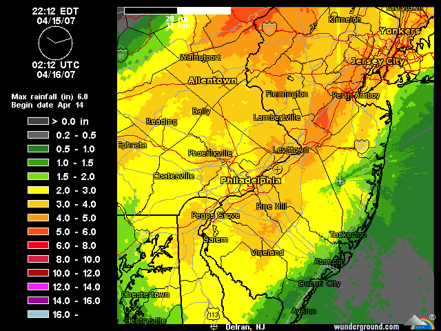
Reports of flooding all around.
Doppler estimates in my area, I'm located at the mark on the center of the map.
Poor quality video I shot earlier
http://s177.photobucket.com/albums/w237 ... nt=021.flv
Reports of flooding all around.
Doppler estimates in my area, I'm located at the mark on the center of the map.
Poor quality video I shot earlier
http://s177.photobucket.com/albums/w237 ... nt=021.flv
0 likes
-
Category 5
- Category 5
- Posts: 10074
- Age: 36
- Joined: Sun Feb 11, 2007 10:00 pm
- Location: New Brunswick, NJ
- Contact:
-
Category 5
- Category 5
- Posts: 10074
- Age: 36
- Joined: Sun Feb 11, 2007 10:00 pm
- Location: New Brunswick, NJ
- Contact:
977.8mb
This is the lowest pressure I've personally ever measured.
This is the lowest pressure I've personally ever measured.
Last edited by Category 5 on Sun Apr 15, 2007 9:40 pm, edited 1 time in total.
0 likes
-
angelwing
- S2K Supporter
- Posts: 4462
- Age: 64
- Joined: Tue Jan 18, 2005 3:06 pm
- Location: Kulpsville, PA
Flood Warning
FLOOD STATEMENT
NATIONAL WEATHER SERVICE MT HOLLY, NEW JERSEY
931 PM EDT SUN APR 15 2007
...THE FLOOD WARNING CONTINUES FOR THE FOLLOWING RIVERS IN PENNSYLVANIA
NESHAMINY CREEK AT LANGHORNE AFFECTING BUCKS COUNTY
PERKIOMEN CREEK AT GRATERFORD AFFECTING MONTGOMERY COUNTY
SCHUYLKILL RIVER AT NORRISTOWN AFFECTING CHESTER...MONTGOMERY AND
PHILADELPHIA COUNTIES
SCHUYLKILL RIVER AT PHILADELPHIA AFFECTING MONTGOMERY AND PHILADELPHIA
COUNTIES
...MAJOR FLOODING IS OCCURRING AND EXPECTED TO CONTINUE ON THE NESHAMINY
CREEK...
...MINOR FLOODING IS OCCURRING AND EXPECTED TO CONTINUE ON THE PERKIOMEN
CREEK...
...MINOR FLOODING IS OCCURRING AND EXPECTED TO CONTINUE ON THE
SCHUYLKILL RIVER...
PAC091-101-161130-
/X.EXT.KPHI.FL.W.0025.000000T0000Z-070416T2308Z/
/PADP1.1.ER.070415T2303Z.070416T0600Z.070416T1708Z.NO/
931 PM EDT SUN APR 15 2007
THE FLOOD WARNING CONTINUES FOR
THE SCHUYLKILL RIVER AT PHILADELPHIA
* UNTIL MONDAY EVENING ...OR UNTIL THE WARNING IS CANCELLED.
* AT 9:00 PM SUNDAY THE STAGE WAS 11.1 FEET
* MINOR FLOODING IS OCCURRING AND MINOR FLOODING IS FORECAST.
* FLOOD STAGE IS 11.0 FEET
* FORECAST...THE RIVER WILL CONTINUE RISING TO NEAR 12.0 FEET AFTER
MIDNIGHT. THE RIVER WILL FALL BELOW FLOOD STAGE EARLY
MONDAY AFTERNOON.
* AT 10.0 FEET...LOW LYING AREAS IN THE FLAT ROCK AREA FLOOD. EAST AND
WEST RIVER DRIVES IN FAIRMONT PARK ARE CLOSED
$$
FLD OBSERVED FORECAST
LOCATION STG STG DAY TIME CREST
SCHUYLKILL RIVER
NORRISTOWN 17.0 15.00 SUN 8 PM 17.0 MON 12 AM
PHILADELPHIA 11.0 11.15 SUN 8 PM 12.0 MON 2 AM
PERKIOMEN CREEK
GRATERFORD 11.0 12.37 SUN 9 PM 11.3 MON 2 AM
NESHAMINY CREEK
LANGHORNE 9.0 13.55 SUN 9 PM 14.5 SUN 11 PM
0 likes
-
JonathanBelles
- Professional-Met
- Posts: 11430
- Age: 35
- Joined: Sat Dec 24, 2005 9:00 pm
- Location: School: Florida State University (Tallahassee, FL) Home: St. Petersburg, Florida
- Contact:
-
Category 5
- Category 5
- Posts: 10074
- Age: 36
- Joined: Sun Feb 11, 2007 10:00 pm
- Location: New Brunswick, NJ
- Contact:
-
JonathanBelles
- Professional-Met
- Posts: 11430
- Age: 35
- Joined: Sat Dec 24, 2005 9:00 pm
- Location: School: Florida State University (Tallahassee, FL) Home: St. Petersburg, Florida
- Contact:


NYC here. Tstorms right now.
Looks like we got some rotation down there over top DelMarVa...
http://radar.weather.gov/radar.php?prod ... x&loop=yes
Looks like we got some rotation down there over top DelMarVa...
http://radar.weather.gov/radar.php?prod ... x&loop=yes
0 likes
-
Category 5
- Category 5
- Posts: 10074
- Age: 36
- Joined: Sun Feb 11, 2007 10:00 pm
- Location: New Brunswick, NJ
- Contact:
-
brunota2003

- S2K Supporter
- Posts: 9476
- Age: 35
- Joined: Sat Jul 30, 2005 9:56 pm
- Location: Stanton, KY...formerly Havelock, NC
- Contact:
O.K., I've been watching this all day now, but tomorrow looks to be just as windy as today here in Eastern NC, here is my wx station: http://www.weatherunderground.com/weath ... =KNCHAVEL3
Ignore the dewpoint, humidity, and temp...I need a new sensor for that (none hooked up for it at this time) The anemometer is on a tree and is sheltered, so just the fact that I'm reading gusts into the teens and 20's is mind-boggling... At Cherry Point (about 1 or 2 miles away) the winds are sustained in the twenties with gusts in the upper 30's and lower 40's...I also took a bunch of video today and plan on taking more tomorrow. Hopefully something happens and they cancel school, so I dont come home to a seven or so hour long video...xD Everyone say safe!
Ignore the dewpoint, humidity, and temp...I need a new sensor for that (none hooked up for it at this time) The anemometer is on a tree and is sheltered, so just the fact that I'm reading gusts into the teens and 20's is mind-boggling...
0 likes
-
Category 5
- Category 5
- Posts: 10074
- Age: 36
- Joined: Sun Feb 11, 2007 10:00 pm
- Location: New Brunswick, NJ
- Contact:
-
angelwing
- S2K Supporter
- Posts: 4462
- Age: 64
- Joined: Tue Jan 18, 2005 3:06 pm
- Location: Kulpsville, PA
Mcguire Air Force Base
Last Update on Apr 15, 11:55 pm EDT
Light Rain
46°F
(8°C) Humidity: 98 %
Wind Speed: N 16 G 21 MPH
Barometer: 28.87" (977.9 mb)
Dewpoint: 45°F (7°C)
Wind Chill: 39°F (4°C)
Visibility: 10.00 mi.
Atlantic City International Airport
Last Update on Apr 15, 11:54 pm EDT
Heavy Rain Fog/Mist
46°F
(8°C) Humidity: 93 %
Wind Speed: NW 18 MPH
Barometer: 28.86" (977.2 mb)
Dewpoint: 44°F (7°C)
Wind Chill: 39°F (4°C)
Visibility: 4.00 mi.
0 likes
-
Category 5
- Category 5
- Posts: 10074
- Age: 36
- Joined: Sun Feb 11, 2007 10:00 pm
- Location: New Brunswick, NJ
- Contact:
-
Category 5
- Category 5
- Posts: 10074
- Age: 36
- Joined: Sun Feb 11, 2007 10:00 pm
- Location: New Brunswick, NJ
- Contact:


Return to “USA & Caribbean Weather”
Who is online
Users browsing this forum: Brushcountry, Cpv17, Greener, txtwister78 and 47 guests