Low Shear in Atlantic
Moderator: S2k Moderators
Forum rules

The posts in this forum are NOT official forecasts and should not be used as such. They are just the opinion of the poster and may or may not be backed by sound meteorological data. They are NOT endorsed by any professional institution or STORM2K. For official information, please refer to products from the National Hurricane Center and National Weather Service.

Low Shear in Atlantic
I have been viewing the shear tendancy maps for the past couple of days and notice shear to be qiut low for this time of the year. I noticed something comparingly similar to this in late April last year, but saw a drastic ramp up of abnormally higher shear values as El Nino became more pronounced. I need to know whether this is normal seasonal values or are we seeing the tell tale signs of an establishing La Nina pattern for the upcomig season. I also observed that waters in the equatorial regions of the Pacific have also continued to cool.
0 likes
-
Coredesat


-
Coredesat


-
MiamiensisWx
Pressures in the MDR appear lower than last year. In addition, note the favorable divergence within the ITCZ and primary flow in the deep tropical Atlantic. Unlike the mean flow in 2006 (which was westerly), we are seeing easterlies in the eastern Atlantic. It is clearly very early, but could this signify a more favorable environment for Cape Verde development? The Bermuda-Azores High is further north and extends further to the west. If this setup continues into September, we may see more landfalls and a more conducive environment (both features were not present in 2006). I'm not jumping to conclusions but I'm taking notice of observations.
In fact most of the western Atlantic is behaving in a more favorable manner than 2006. Pressures are lower in most of the Caribbean Sea. Shear is high but this is typical before late August and September. Overall conditions look much different than 2006. This is going to be an interesting season. Let's hope for no landfalls and a great fish tracking season! As a south Florida resident, I dearly hope we get another break.
In fact most of the western Atlantic is behaving in a more favorable manner than 2006. Pressures are lower in most of the Caribbean Sea. Shear is high but this is typical before late August and September. Overall conditions look much different than 2006. This is going to be an interesting season. Let's hope for no landfalls and a great fish tracking season! As a south Florida resident, I dearly hope we get another break.
0 likes

Actually, vertical shear in the Caribbean over the past few days and overall it has been under climatology, along with other trending favorable conditions it would be safe to say that we could have an active beginning of the hurricane season in the Caribbean, and since we know that ENSO is going to stay at least neutral, conditions in the Caribbean should stay favorable through September and or October.
0 likes
NDG:
Do you have any more information about those shear plots you posted? I've never seen that in chart form and vs climo before.
Where did you get it? How's it calculated (what levels/stations? Or maybe it's satellite/cloud wind derived???). Is it available in chart form vs climo like that for other parts of the Atlantic/Carib/Gulf?
Thanks
WJS3
0 likes
-
wxman57

- Moderator-Pro Met

- Posts: 23131
- Age: 68
- Joined: Sat Jun 21, 2003 8:06 pm
- Location: Houston, TX (southwest)
Re: Low Shear in Atlantic
Anthonyl wrote:I have been viewing the shear tendancy maps for the past couple of days and notice shear to be qiut low for this time of the year. I noticed something comparingly similar to this in late April last year, but saw a drastic ramp up of abnormally higher shear values as El Nino became more pronounced. I need to know whether this is normal seasonal values or are we seeing the tell tale signs of an establishing La Nina pattern for the upcomig season. I also observed that waters in the equatorial regions of the Pacific have also continued to cool.
Careful not to confuse shear tendency maps with wind shear. The shear tendency maps only indicate where shear is increasing or decreasing, they do not indicate the amount of shear across the tropics.
0 likes
-
Coredesat
Re: Low Shear in Atlantic
wxman57 wrote:Careful not to confuse shear tendency maps with wind shear. The shear tendency maps only indicate where shear is increasing or decreasing, they do not indicate the amount of shear across the tropics.
Indeed, looking at the map I linked earlier, shear has increased again over most of the basin, although the jet seems to have moved a bit.
0 likes
wjs3 wrote:Thanks. I'll poke around at the CSU site in the meantime.
WJS3
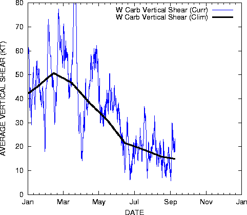
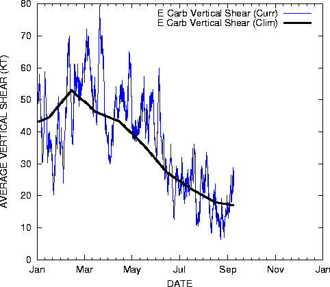
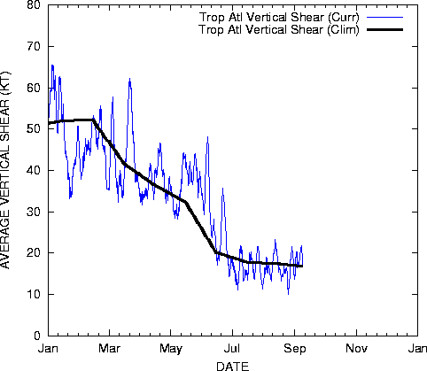
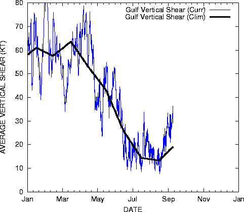
Here you go:
Atlantic average vertical shear index
E Caribbean average vertical shear index
W Caribbean average vertical shear index
GOM average vertical shear index
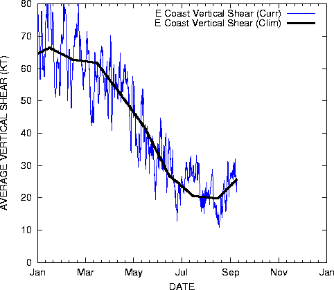
E coast vertical shear index
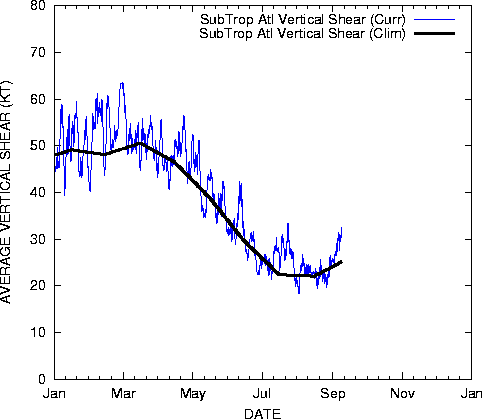
Subtropical Atlantic vert shear index
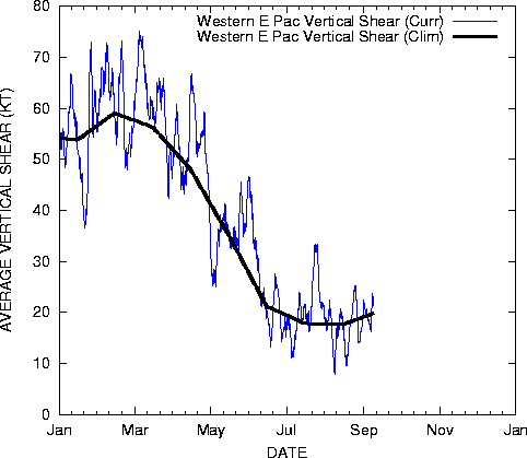
West. E Pacific vert shear index
E Pacific vert shear index
0 likes

-
milankovitch

- Tropical Storm

- Posts: 243
- Age: 40
- Joined: Fri Sep 17, 2004 11:30 pm
- Location: Menands, NY; SUNY Albany
- Contact:
http://www.weatherunderground.com/blog/ ... amp=200704
http://www.cpc.ncep.noaa.gov/products/a ... cast.shtml
Forecast shear from CPC NCEP coupled forecast system model
0 likes
Who is online
Users browsing this forum: Hammy and 70 guests