North Texas Weather - A Brief Break from the Rain?
Moderator: S2k Moderators
Forum rules

The posts in this forum are NOT official forecast and should not be used as such. They are just the opinion of the poster and may or may not be backed by sound meteorological data. They are NOT endorsed by any professional institution or STORM2K.
-
Category 5

- Category 5

- Posts: 10074
- Age: 36
- Joined: Sun Feb 11, 2007 10:00 pm
- Location: New Brunswick, NJ
- Contact:
-
Category 5
- Category 5
- Posts: 10074
- Age: 36
- Joined: Sun Feb 11, 2007 10:00 pm
- Location: New Brunswick, NJ
- Contact:
Tornado Warning
SEVERE WEATHER STATEMENT
NATIONAL WEATHER SERVICE FORT WORTH TX
915 PM CDT TUE APR 24 2007
TXC439-250230-
/O.CON.KFWD.TO.W.0028.000000T0000Z-070425T0230Z/
TARRANT TX-
915 PM CDT TUE APR 24 2007
...A TORNADO WARNING REMAINS IN EFFECT UNTIL 930 PM CDT FOR NORTHERN
TARRANT COUNTY...
AT 915 PM CDT...STORM SPOTTERS AND DOPPLER RADAR OBSERVED A
DEVELOPING TORNADO. THIS TORNADO WAS LOCATED 1 MILE EAST OF
RIVER OAKS...MOVING EAST AT 20 MPH. SPOTTER REPORTS OF 60 MPH WIND
AND OCCASIONAL FUNNEL CLOUDS HAVE BEEN RECEIVED.
THE TORNADO WILL BE NEAR...
BLUE MOUND AND HASLET BY 920 PM CDT...
HALTOM CITY BY 925 PM CDT...
RICHLAND HILLS...NORTH RICHLAND HILLS...HURST AND WATAUGA BY 930 PM
CDT...
A TORNADO WATCH REMAINS IN EFFECT UNTIL 1000 PM CDT TUESDAY EVENING
FOR NORTH CENTRAL TEXAS. A TORNADO WATCH ALSO REMAINS IN EFFECT UNTIL
1100 PM CDT TUESDAY EVENING FOR EASTERN TEXAS.
LAT...LON 3298 9741 3272 9750 3274 9703 3299 9704
$$
0 likes
-
TexasStooge

- Category 5
- Posts: 38127
- Joined: Tue Mar 25, 2003 1:22 pm
- Location: Irving (Dallas County), TX
- Contact:
[font=Arial]The National Weather Service has issued a SEVERE THUNDERSTORM WARNING for persons in Denton County until 10:15PM CDT.[/font]
NWS - Fort Worth wrote:[font=Courier New]* AT 906 PM CDT...NATIONAL WEATHER SERVICE METEOROLOGISTS DETECTED A
SEVERE THUNDERSTORM CAPABLE OF PRODUCING NICKEL SIZE HAIL...AND
DAMAGING WINDS IN EXCESS OF 60 MPH. THIS STORM WAS LOCATED NEAR
ROANOKE...OR ABOUT NEAR HASLET...AND MOVING NORTHEAST AT 45 MPH.
* THE SEVERE THUNDERSTORM WILL BE NEAR...
BARTONVILLE...DOUBLE OAK...ARGYLE AND FLOWER MOUND BY 915 PM
COPPER CANYON...CORINTH...HIGHLAND VILLAGE AND DENTON BY 920 PM
LAKE DALLAS AND HICKORY CREEK BY 925 PM
FOR YOUR PROTECTION MOVE TO A STURDY SHELTER UNTIL THE STORM HAS
PASSED.
A TORNADO WATCH IS IN EFFECT FOR THE WARNING AREA. SEVERE
THUNDERSTORMS CAN PRODUCE TORNADOES WITH LITTLE OR NO WARNING.
LAT...LON 3316 9738 3298 9739 3301 9684 3328 9684[/font]
0 likes
-
Dr. Jonah Rainwater

- Category 2

- Posts: 569
- Joined: Sat Jul 23, 2005 2:45 pm
- Location: Frisco, Texas
- Contact:
I'm not sure where the tornado is located...it could be anywhere between I-30 and I-820N in Fort Worth assuming that there is one on the ground. This is a really nasty looking storm and I imagine the damage will be significantly worse than the Haltom City storm on the 13th.
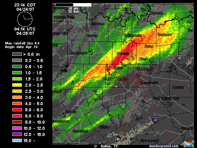
This entire line is impressive! It extends from a defined bow echo east of Bonham stretching into a large mass of red and orange in Collin and Denton counties, followed by this supercell in Denton/Tarrant county and another powerful looking bow echo in Johnson and Hill counties moving towards Ellis. To the west, another cell just erupted in Palo Pino county...deja vu...gonna be a long night!
This entire line is impressive! It extends from a defined bow echo east of Bonham stretching into a large mass of red and orange in Collin and Denton counties, followed by this supercell in Denton/Tarrant county and another powerful looking bow echo in Johnson and Hill counties moving towards Ellis. To the west, another cell just erupted in Palo Pino county...deja vu...gonna be a long night!
0 likes
-
TexasStooge
- Category 5
- Posts: 38127
- Joined: Tue Mar 25, 2003 1:22 pm
- Location: Irving (Dallas County), TX
- Contact:
[font=Arial]The National Weather Service has issued a SEVERE THUNDERSTORM WARNING for persons in Dallas and Ellis Counties until 10:15PM CDT.[/font]
NWS - Fort Worth wrote:[font=Courier New]* AT 916 PM CDT...NATIONAL WEATHER SERVICE METEOROLOGISTS DETECTED A
LINE OF SEVERE THUNDERSTORMS CAPABLE OF PRODUCING PENNY SIZE
HAIL...AND DESTRUCTIVE WINDS IN EXCESS OF 70 MPH. THESE STORMS
WERE LOCATED ALONG A LINE EXTENDING FROM 17 MILES WEST OF
MIDLOTHIAN TO 11 MILES WEST OF MAYPEARL TO 15 MILES SOUTHWEST OF
MAYPEARL...AND MOVING NORTHEAST AT 55 MPH.
* SEVERE THUNDERSTORMS WILL BE NEAR...
MIDLOTHIAN...MAYPEARL AND ITALY BY 930 PM
CEDAR HILL BY 935 PM
WAXAHACHIE...OVILLA...OAK LEAF AND GLENN HEIGHTS BY 940 PM
RED OAK AND LANCASTER BY 945 PM
IF YOU ARE CAUGHT OUTSIDE...SEEK SHELTER IN A STRONG BUILDING AND
STAY INSIDE...AWAY FROM WINDOWS UNTIL THE STORM HAS PASSED.
LAT...LON 3256 9709 3242 9708 3227 9707 3207 9693
3233 9642 3254 9652 3276 9652[/font]
0 likes
-
TexasStooge
- Category 5
- Posts: 38127
- Joined: Tue Mar 25, 2003 1:22 pm
- Location: Irving (Dallas County), TX
- Contact:
[font=Arial]The National Weather Service has issued a FLASH FLOOD WARNING for persons in Grayson County until 12:15AM CDT Wednesday.[/font]
NWS - Fort Worth wrote:[font=Courier New]* AT 916 PM CDT...LAW ENFORCEMENT REPORTED FLOODING IN SOUTHERN
GRAYSON COUNTY. ADDITIONAL STORMS WILL AFFECT THE WARNED AREA OVER
THE NEXT SEVERAL HOURS AND ANOTHER INCH IS POSSIBLE OVER THE
AFFECTED AREA. THIS MAY CAUSE ADDITIONAL FLOODING PROBLEM.
* LOCATIONS IN THE WARNING INCLUDE BUT ARE NOT LIMITED TO SHERMAN...
TIOGA...GUNTER...KNOLLWOOD AND BELLS
EXCESSIVE RUNOFF FROM THIS STORM WILL CAUSE FLASH FLOODING OF SMALL
CREEKS AND STREAMS...HIGHWAYS AND UNDERPASSES. ADDITIONALLY...COUNTRY
ROADS AND FARMLANDS ALONG THE BANKS OF CREEKS AND STREAMS AND OTHER
LOW LYING AREAS ARE SUBJECT TO FLASH FLOODING.
BE ESPECIALLY CAUTIOUS AT NIGHT WHEN IT IS HARDER TO RECOGNIZE THE
DANGERS OF FLOODS AND FLASH FLOODS. IF FLASH FLOODING IS OBSERVED ACT
QUICKLY. MOVE UP TO HIGHER GROUND TO ESCAPE FLOOD WATERS. DO NOT STAY
IN AREAS SUBJECT TO FLOODING WHEN WATER BEGINS RISING.
A FLASH FLOOD WARNING MEANS THAT FLOODING IS IMMINENT OR OCCURRING.
RESIDENTS LIVING ALONG STREAMS AND CREEKS SHOULD TAKE IMMEDIATE
PRECAUTIONS TO PROTECT LIFE AND PROPERTY. DO NOT ATTEMPT TO CROSS
SWIFTLY FLOWING WATERS OR WATERS OF UNKNOWN DEPTH BY FOOT OR BY
AUTOMOBILE.
LAT...LON 3343 9694 3340 9683 3340 9667 3340 9638
3374 9637 3378 9646 3362 9694 3355 9694[/font]
0 likes
-
TexasStooge
- Category 5
- Posts: 38127
- Joined: Tue Mar 25, 2003 1:22 pm
- Location: Irving (Dallas County), TX
- Contact:
[font=Arial]The good news is that the TORNADO WARNING for Tarrant County has been allowed to expire. It seems the storm capable of producing a tornado has dissipated. However, the National Weather Service has issued a SEVERE THUNDERSTORM WARNING for persons in Tarrant County until 10:30PM CDT.[/font]
NWS - Fort Worth wrote:[font=Courier New]* AT 932 PM CDT...NATIONAL WEATHER SERVICE METEOROLOGISTS DETECTED A
SEVERE THUNDERSTORM CAPABLE OF PRODUCING PENNY SIZE HAIL...AND
DAMAGING WINDS IN EXCESS OF 60 MPH. THIS STORM WAS LOCATED NEAR
HURST...AND MOVING EAST AT 25 MPH.
* THE SEVERE THUNDERSTORM WILL BE NEAR...
EULESS BY 940 PM
GRAPEVINE BY 945 PM
FOR YOUR PROTECTION MOVE TO A STURDY SHELTER UNTIL THE STORM HAS
PASSED.
A TORNADO WATCH IS IN EFFECT FOR THE WARNING AREA. SEVERE
THUNDERSTORMS CAN PRODUCE TORNADOES WITH LITTLE OR NO WARNING.
LAT...LON 3299 9729 3274 9728 3274 9703 3299 9704[/font]
0 likes
-
Dr. Jonah Rainwater
- Category 2
- Posts: 569
- Joined: Sat Jul 23, 2005 2:45 pm
- Location: Frisco, Texas
- Contact:
-
Dr. Jonah Rainwater
- Category 2
- Posts: 569
- Joined: Sat Jul 23, 2005 2:45 pm
- Location: Frisco, Texas
- Contact:
I went for a drive up Coit during the height of the storm...I saw very heavy rain and brilliant lightning with pea-sized hail falling at times. I'd estimate the winds were probably gusting to around 40 or 50mph. Some side roads were impassable due to high water, and debris was everywhere in the form of tree branches, garbage cans, and orange traffic barricades scattered across the roads. The storm is winding down now.
0 likes
-
Category 5
- Category 5
- Posts: 10074
- Age: 36
- Joined: Sun Feb 11, 2007 10:00 pm
- Location: New Brunswick, NJ
- Contact:
-
TexasStooge
- Category 5
- Posts: 38127
- Joined: Tue Mar 25, 2003 1:22 pm
- Location: Irving (Dallas County), TX
- Contact:
Although the worst has passed us, the clean-up continues. At about High Noon CDT, several severe thunderstorms developed ahead of a dry line which often resulted in possible tornado developments, hail almost to the size of golf balls, and destructive winds in excess of 70 MPH. Although there was no official tornado warning for Dallas County, the sirens in Irving were sounded as a precautionary measure. 20 homes in the Flower Mound area are requiring major repairs after a small tornado touched down, according to a fire dept. official. The Salvation Army dispatched a mobile disaster unit to assist displaced residents. A couple of hours later, more storm developments with the same ingredients. Also to add insult to injury, 8 to 10 inches of rain fell in Denton, TX; putting some homes and businesses in danger, especially along lakes, rivers, and creeks. The National Weather Service is surveying the damage and will determing the Enhanced Fujita Scale rating of the twisters. Our next chance of thunderstorms will be on Friday evening, but severe weather is unlikely.
[font=arial]DFW Forecast
Today: 75°F
75°F
Tonight: 51°F
51°F
Thursday: 75°F | 55°F
Friday: 77°F | 57°F
Saturday: 81°F | 62°F
Sunday: 84°F | 62°F
Monday: 85°F | 63°F
Tuesday: 84°F[/font]
[hr]
See WFAA-TV's weather blog for the timeline of the storms.
[font=arial]DFW Forecast
Today:
75°F
Tonight:
51°F
Thursday:
75°F | 55°F
Friday:
77°F | 57°F
Saturday:
81°F | 62°F
Sunday:
84°F | 62°F
Monday:
85°F | 63°F
Tuesday:
84°F[/font]
[hr]
See WFAA-TV's weather blog for the timeline of the storms.
0 likes
-
TexasStooge
- Category 5
- Posts: 38127
- Joined: Tue Mar 25, 2003 1:22 pm
- Location: Irving (Dallas County), TX
- Contact:
The National Weather Service has confirmed that 3 tornadoes struck Denton and Hood Counties on April 24. In Hood County, a Tornado has touched down and moved through portions of the Pecan Plantation Community. The most observed damage was to a brick house where a roof was blown off, a tree was uprooted, the garage door was blown in and windows are busted. This tornado has been given an EF-1. In Denton County the first tornado touched down in the Lincoln Park Community causing significant roof damage and snapped tree limbs. The second one touched down in Flower Mound, also causing roof damages and snapped trees. Both of those twisters have been given an EF-0, however, the tornado in Flower Mound may be upgraded to an EF-1 as additional engineering is reviewed.
Otherwise, we'll see a semi-nice 7 days with mostly sunny to partly cloudy skies with highs in the 70s and 80s. We will see another round of thunderstorms on Saturday and Monday, but severe weather will be slim to none.
[font=arial]DFW Forecast
Today: 73°F
73°F
Tonight: 53°F
53°F
Friday: 79°F | 59°F
Saturday: 77°F | 56°F
Sunday: 83°F | 61°F
Monday: 85°F | 65°F
Tuesday: 83°F | 66°F
Wednesday: 82°F[/font]
Otherwise, we'll see a semi-nice 7 days with mostly sunny to partly cloudy skies with highs in the 70s and 80s. We will see another round of thunderstorms on Saturday and Monday, but severe weather will be slim to none.
[font=arial]DFW Forecast
Today:
73°F
Tonight:
53°F
Friday:
79°F | 59°F
Saturday:
77°F | 56°F
Sunday:
83°F | 61°F
Monday:
85°F | 65°F
Tuesday:
83°F | 66°F
Wednesday:
82°F[/font]
0 likes
-
TexasStooge
- Category 5
- Posts: 38127
- Joined: Tue Mar 25, 2003 1:22 pm
- Location: Irving (Dallas County), TX
- Contact:
It seems we may have a nice weekend after all. The chances of rain for Today and Saturday have dissipated, although skies will be overcasting on Friday Morning. By the beginning of next week, we'll see yet another round of thunderstorms with our best chances--guess what?--on Tuesday. Could this be a repeat performance of April 24th? Quite unlikely, but we'll continue to look at the SPC outlooks.
[font=arial]DFW Forecast
Today: 80°F
Tonight: 59°F
59°F
Saturday: 80°F | 55°F
Sunday: 84°F | 61°F
Monday: 81°F | 64°F
Tuesday: 78°F | 66°F
Wednesday: 83°F | 66°F
Thursday: 84°F[/font]
[font=arial]DFW Forecast
Today:
80°F
Tonight:
59°F
Saturday:
80°F | 55°F
Sunday:
84°F | 61°F
Monday:
81°F | 64°F
Tuesday:
78°F | 66°F
Wednesday:
83°F | 66°F
Thursday:
84°F[/font]
0 likes
-
TexasStooge
- Category 5
- Posts: 38127
- Joined: Tue Mar 25, 2003 1:22 pm
- Location: Irving (Dallas County), TX
- Contact:
Well, I said it before and I'll say it again, we're gonna have a nice weekend. There's no need for umbrellas...at least until Monday when we have another storm system all week. This time, the storms are not gonna be violent as the past 3 weeks were and flooding is highly unlikely. However, we may get some beneficial rain.
[font=arial]DFW Forecast
Today: 82°F
Tonight: 59°F
Sunday: 84°F | 64°F
Monday: 77°F | 62°F
Tuesday: 77°F | 61°F
Wednesday: 78°F | 62°F
Thursday: 79°F | 63°F
Friday: 83°F[/font]
[font=arial]DFW Forecast
Today:
82°F
Tonight:
59°F
Sunday:
84°F | 64°F
Monday:
77°F | 62°F
Tuesday:
77°F | 61°F
Wednesday:
78°F | 62°F
Thursday:
79°F | 63°F
Friday:
83°F[/font]
0 likes


-
TexasStooge
- Category 5
- Posts: 38127
- Joined: Tue Mar 25, 2003 1:22 pm
- Location: Irving (Dallas County), TX
- Contact:
-
TexasStooge
- Category 5
- Posts: 38127
- Joined: Tue Mar 25, 2003 1:22 pm
- Location: Irving (Dallas County), TX
- Contact:
[font=Arial]This is gonna be a wet week all this week with the heaviest rain happening today and tomorrow. While none of the thunderstorms appear to be severe, they can still pose a flooding hazard, thus a Flash Flood Watch is in effect for the middle 2/3rds of North Texas; including the Dallas/Fort Worth metroplex, Gainesville, Sherman, Decatur, Denton, Greenville, Meridian, Hillsboro, Corsicana, and Waco through Tuesday Morning. More than likely, it will be extended and/or enlarged as the week progresses.[/font]
[font=arial]DFW Forecast
Today: 81°F
81°F
Tonight: 65°F
Tuesday: 77°F | 65°F
Wednesday: 80°F | 67°F
Thursday: 82°F | 67°F
Friday: 84°F | 67°F
Saturday: 87°F | 69°F
Sunday: 84°F[/font]
[hr]
Matter in fact, areas of showers and thunderstorms continue to develop along the I-35 Corridor and drifting Northeast at 30 MPH. The strongest storms are capable of frequent cloud to ground lightning and heavy rain. More development is on the way today.

NWS - Fort Worth wrote:[font=Courier New]* A SLOW MOVING UPPER LEVEL STORM SYSTEM COMBINED WITH DEEP GULF
MOISTURE WILL PRODUCE SCATTERED TO NUMEROUS SHOWERS AND
THUNDERSTORMS OVER NORTH TEXAS TODAY. RECENT RAINFALL HAS LEFT
SOILS SATURATED ACROSS MUCH OF NORTH TEXAS...AND ANY ADDITIONAL
HEAVY RAINFALL WILL QUICKLY RUNOFF AND CREATE THE POTENTIAL FOR
FLASH FLOODING. THROUGH TUESDAY...AVERAGE RAINFALL AMOUNTS OF 1
TO 2 INCHES ARE EXPECTED ACROSS THE WATCH AREA WITH ISOLATED
TOTALS OF UP TO 4 INCHES POSSIBLE.
A FLASH FLOOD WATCH MEANS THAT CONDITIONS ARE FAVORABLE FOR HEAVY
RAIN WHICH MAY LEAD TO FLASH FLOODING. YOU SHOULD MONITOR THE
LATEST FORECASTS FROM THE NATIONAL WEATHER SERVICE AND BE
PREPARED TO TAKE ACTION SHOULD FLASH FLOOD WARNINGS BE ISSUED FOR
YOUR AREA.[/font]
[font=arial]DFW Forecast
Today:
81°F
Tonight:
65°F
Tuesday:
77°F | 65°F
Wednesday:
80°F | 67°F
Thursday:
82°F | 67°F
Friday:
84°F | 67°F
Saturday:
87°F | 69°F
Sunday:
84°F[/font]
[hr]
Matter in fact, areas of showers and thunderstorms continue to develop along the I-35 Corridor and drifting Northeast at 30 MPH. The strongest storms are capable of frequent cloud to ground lightning and heavy rain. More development is on the way today.
0 likes
-
TexasStooge
- Category 5
- Posts: 38127
- Joined: Tue Mar 25, 2003 1:22 pm
- Location: Irving (Dallas County), TX
- Contact:
[font=Arial]The National Weather Service has extended and enlarged the Flash Flood Watch to include the eastern 2/3rds of North Texas through Tuesday Afternoon.[/font]
NWS - Fort Worth wrote:[font=Courier New]* A SLOW MOVING UPPER LEVEL STORM SYSTEM COMBINED WITH DEEP GULF
MOISTURE WILL RESULT IN WIDESPREAD PRECIPITATION TONIGHT AND
TUESDAY. RECENT RAINFALL HAS LEFT SOILS SATURATED ACROSS MUCH OF
THE WATCH AREA...AND ANY ADDITIONAL HEAVY RAINFALL WILL QUICKLY
RUNOFF AND CREATE THE POTENTIAL FOR FLASH FLOODING. THROUGH
TUESDAY...AVERAGE RAINFALL AMOUNTS OF 1 TO 2 INCHES ARE EXPECTED
ACROSS THE WATCH AREA WITH ISOLATED TOTALS OF UP TO 4 INCHES
POSSIBLE.
* AREAS FROM PARKER COUNTY...THROUGH DENTON...INTO PORTIONS OF
COLLIN AND GRAYSON COUNTIES...RECEIVED IN EXCESS OF 4 INCHES OF
RAIN IN THE LAST WEEK. FOLLOWING EXTENSIVE FLOODING LAST WEEK...
DENTON COUNTY WILL BE THE MOST PRONE TO RAPID FLASH FLOODING
ISSUES.
A FLASH FLOOD WATCH MEANS THAT CONDITIONS ARE FAVORABLE FOR HEAVY
RAIN WHICH MAY LEAD TO FLASH FLOODING. YOU SHOULD MONITOR THE
LATEST FORECASTS FROM THE NATIONAL WEATHER SERVICE AND BE
PREPARED TO TAKE ACTION SHOULD FLASH FLOOD WARNINGS BE ISSUED FOR
YOUR AREA.[/font]
0 likes
-
TexasStooge
- Category 5
- Posts: 38127
- Joined: Tue Mar 25, 2003 1:22 pm
- Location: Irving (Dallas County), TX
- Contact:
The Flash Flood Watch continues in effect for the western 2/3rds of North Texas (including DFW) until 4:00PM CDT this afternoon. To add insult to injury, some of these storms could be (yep, you said it) severe with damaging winds and hail to the size of quarters, thus a slight risk of severe weather is outlined for most of North Texas. The severe threat however will remain south of the I-20 Corridor, so that's a little reprieve for the immediate DFW area.
[font=arial]DFW Forecast
Today: 76°F
Tonight: 65°F
Wednesday: 80°F | 67°F
Thursday: 82°F | 67°F
Friday: 75°F | 59°F
Saturday: 86°F | 69°F
Sunday: 84°F | 69°F
Monday: 83°F[/font]
[font=arial]DFW Forecast
Today:
76°F
Tonight:
65°F
Wednesday:
80°F | 67°F
Thursday:
82°F | 67°F
Friday:
75°F | 59°F
Saturday:
86°F | 69°F
Sunday:
84°F | 69°F
Monday:
83°F[/font]
0 likes
-
TexasStooge
- Category 5
- Posts: 38127
- Joined: Tue Mar 25, 2003 1:22 pm
- Location: Irving (Dallas County), TX
- Contact:
The Flash Flood Watch that was in effect for the eastern 2/3rds of North Texas has been allowed to expire. However, we need to keep an eye on the southern part of North Texas, mainly along and south of a Comanche, and Waco line where a slight risk of severe weather is outlined.
In the meantime, light showers and thunderstorms will continue to redevelop through the remainder of the week. Quite likely, the flood threat will continue, but it's not gonna be a major event.
In the meantime, light showers and thunderstorms will continue to redevelop through the remainder of the week. Quite likely, the flood threat will continue, but it's not gonna be a major event.
0 likes
Return to “USA & Caribbean Weather”
Who is online
Users browsing this forum: No registered users and 64 guests