


Luckily it appears it will miss to the north.
SEVERE WEATHER STATEMENT
NATIONAL WEATHER SERVICE HOUSTON/GALVESTON TX
535 PM CDT THU MAY 3 2007
TXC201-291-339-032315-
/O.CON.KHGX.TO.W.0012.000000T0000Z-070503T2315Z/
MONTGOMERY TX-LIBERTY TX-HARRIS TX-
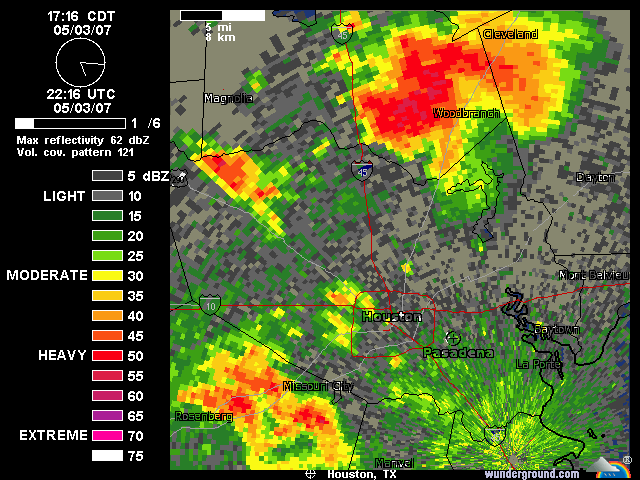
535 PM CDT THU MAY 3 2007
...A TORNADO WARNING CONTINUES FOR EXTREME NORTHEAST
HARRIS...LIBERTY AND EASTERN MONTGOMERY COUNTIES UNTIL 615 PM CDT...
AT 532 PM CDT...NATIONAL WEATHER SERVICE DOPPLER RADAR INDICATED A
LARGE SEVERE THUNDERSTORM CAPABLE OF PRODUCING A TORNADO OVER
EASTERN MONTGOMERY COUNTY...MOVING EAST AT 25 MPH. RADAR SIGNATURE
SUGGESTS A STRONG TORNADO IN THE NEW CANEY AREA. IN ADDITION...HAIL
OF GOLFBALL SIZE OR LARGER AND DAMAGING WINDS ARE LIKELY WITH THIS
STORM. PLEASE SEEK SHELTER IMMEDIATELY!!!
* LOCATIONS IMPACTED INCLUDE...
ROMAN FOREST...
PATTON VILLAGE...
SPLENDORA...
WOODBRANCH...
NEW CANEY...
US HIGHWAY 59...
KINGWOOD...
CLEVELAND...
PLUM GROVE...
PLEASE REPORT SEVERE WEATHER TO THE COUNTY SHERIFF...LOCAL
POLICE...OR DEPARTMENT OF PUBLIC SAFETY. THEY WILL RELAY YOUR REPORT
TO THE NATIONAL WEATHER SERVICE.
LAT...LON 3026 9535 3011 9538 3004 9517 3006 9486
3046 9485
$$


