EF5 Tornado levels Greensburg Kansas.

U.S. & Caribbean Weather Discussions and Severe Weather Events

Moderator: S2k Moderators

Forum rules

The posts in this forum are NOT official forecast and should not be used as such. They are just the opinion of the poster and may or may not be backed by sound meteorological data. They are NOT endorsed by any professional institution or STORM2K.

Help Support Storm2K
Message
Author
User avatar
Category 5
Category 5
Category 5
Posts: 10074
Age: 35
Joined: Sun Feb 11, 2007 10:00 pm
Location: New Brunswick, NJ
Contact:

EF5 Tornado levels Greensburg Kansas.

#1 Postby Category 5 » Fri May 04, 2007 9:46 pm

SEVERE WEATHER STATEMENT
NATIONAL WEATHER SERVICE DODGE CITY KS
941 PM CDT FRI MAY 4 2007

KSC097-050300-
/O.CON.KDDC.TO.W.0025.000000T0000Z-070505T0300Z/
KIOWA KS-
941 PM CDT FRI MAY 4 2007

...A TORNADO WARNING REMAINS IN EFFECT UNTIL 1000 PM CDT FOR CENTRAL
KIOWA COUNTY...

...A TORNADO EMERGENCY FOR GREENSBURG....

AT 937 PM CDT...NATIONAL WEATHER SERVICE METEOROLOGISTS AND STORM
SPOTTERS WERE TRACKING A LARGE AND EXTREMELY DANGEROUS TORNADO. THIS
TORNADO WAS LOCATED 5 MILES SOUTH OF GREENSBURG...MOVING NORTH AT 20
MPH.

A VIOLENT TORNADO WAS ON A DIRECT PATH FOR PORTIONS OF GREENSBURG...
ESPECIALLY THE EASTERN PORTIONS OF TOWN. TAKE IMMEDIATE TORNADO
PRECATIONS...THIS IS AN EMERGENCY SITUATION FOR GREENSBURG!!

A TORNADO WATCH REMAINS IN EFFECT UNTIL 200 AM CDT SATURDAY MORNING
FOR SOUTHWESTERN KANSAS.

LAT...LON 3749 9936 3745 9929 3760 9901 3764 9936

$$

UMSCHEID

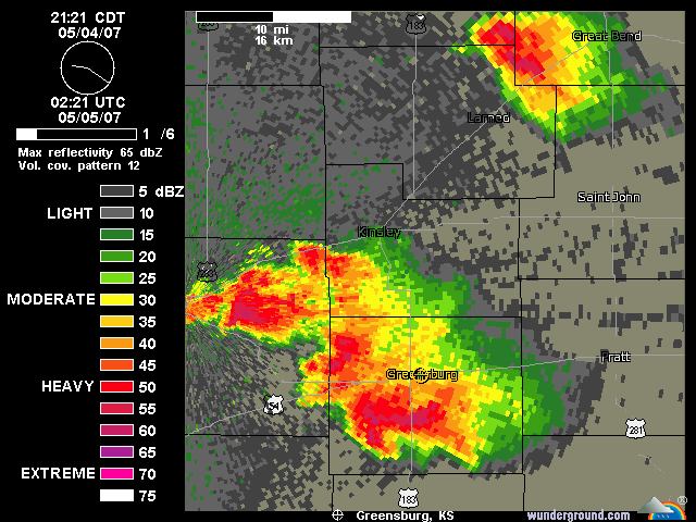
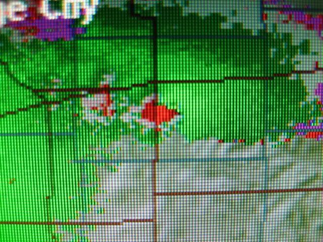
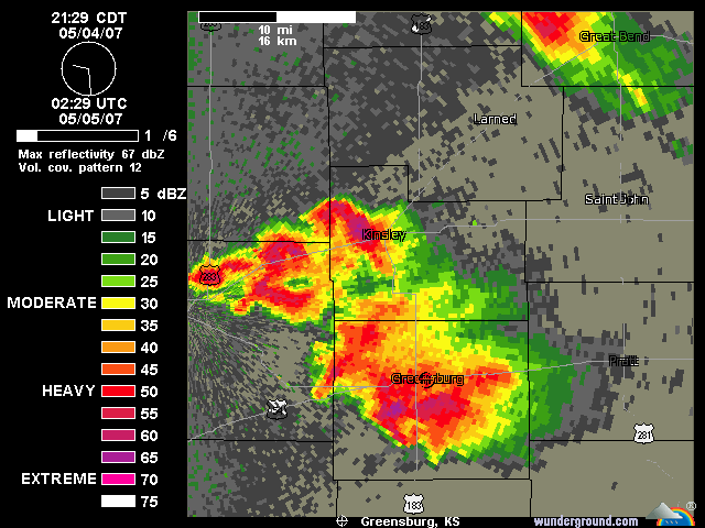
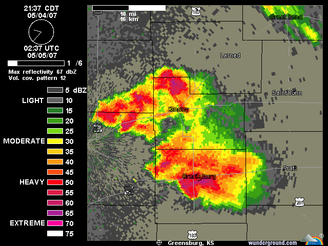
Look at this cell. no question a tornado with this.
Image
Last edited by Category 5 on Tue Jun 12, 2007 7:23 pm, edited 17 times in total.
0 likes   

User avatar
Category 5
Category 5
Category 5
Posts: 10074
Age: 35
Joined: Sun Feb 11, 2007 10:00 pm
Location: New Brunswick, NJ
Contact:

#2 Postby Category 5 » Fri May 04, 2007 9:53 pm

Image
0 likes   

User avatar
Category 5
Category 5
Category 5
Posts: 10074
Age: 35
Joined: Sun Feb 11, 2007 10:00 pm
Location: New Brunswick, NJ
Contact:

#3 Postby Category 5 » Fri May 04, 2007 9:56 pm

Reports state a wedge tornado possably a mile wide.

It is ripping up greenburg right now

Image
0 likes   

User avatar
Category 5
Category 5
Category 5
Posts: 10074
Age: 35
Joined: Sun Feb 11, 2007 10:00 pm
Location: New Brunswick, NJ
Contact:

#4 Postby Category 5 » Fri May 04, 2007 9:57 pm

TORNADO WARNING
KSC047-097-050330-
/O.NEW.KDDC.TO.W.0026.070505T0250Z-070505T0330Z/

BULLETIN - EAS ACTIVATION REQUESTED
TORNADO WARNING
NATIONAL WEATHER SERVICE DODGE CITY KS
950 PM CDT FRI MAY 4 2007

THE NATIONAL WEATHER SERVICE IN DODGE CITY HAS ISSUED A

* TORNADO WARNING FOR...
SOUTHEASTERN EDWARDS COUNTY IN SOUTH CENTRAL KANSAS.
NORTHEASTERN KIOWA COUNTY IN SOUTH CENTRAL KANSAS.

* UNTIL 1030 PM CDT

* AT 945 PM CDT...NATIONAL WEATHER SERVICE METEOROLOGISTS WERE
TRACKING A CONFIRMED LARGE AND EXTREMELY DANGEROUS TORNADO 2 MILES
SOUTH OF GREENSBURG...MOVING NORTHEAST AT 30 MPH.

* LOCATIONS IMPACTED INCLUDE...
GREENSBURG...
CENTERVIEW...
FELLSBURG...
RURAL RESIDENCES OF NORTHEASTERN KIOWA AND SOUTHEASTERN EDWARDS
COUNTIES.

THIS INCLUDES HIGHWAY 54 BETWEEN MILE MARKERS 107 AND 117.

IN ADDITION TO THE TORNADO...THIS STORM IS CAPABLE OF PRODUCING
GOLFBALL SIZE HAIL AND DESTRUCTIVE STRAIGHT LINE WINDS.

THIS IS AN EXTREMELY DANGEROUS AND LIFE THREATENING SITUATION. A
LARGE TORNADO HAS BEEN CONFIRMED!. IF YOU ARE IN THE PATH OF THIS
DESTRUCTIVE TORNADO...TAKE COVER IMMEDIATELY IN A BASEMENT OR OTHER
UNDERGROUND SHELTER AND GET UNDER SOMETHING STURDY.

THIS WARNING REPLACES THE PREVIOUS WARNING FOR KIOWA COUNTY.

LAT...LON 3756 9933 3753 9924 3773 9898 3788 9927

$$

UMSCHEID
0 likes   

snoopj
Category 2
Category 2
Posts: 530
Joined: Wed Sep 10, 2003 9:46 pm
Location: KCMO
Contact:

#5 Postby snoopj » Fri May 04, 2007 9:58 pm

I'll post some GR2A pics after I'm done getting past this sick feeling that Greensburg got slammed.
0 likes   

User avatar
Category 5
Category 5
Category 5
Posts: 10074
Age: 35
Joined: Sun Feb 11, 2007 10:00 pm
Location: New Brunswick, NJ
Contact:

#6 Postby Category 5 » Fri May 04, 2007 9:59 pm

Greensburg is probably devestated (being devestated)

This thing is cutting through there as we speak.
0 likes   

HurricaneBill
Category 5
Category 5
Posts: 3420
Joined: Sun Apr 11, 2004 5:51 pm
Location: East Longmeadow, MA, USA

#7 Postby HurricaneBill » Fri May 04, 2007 9:59 pm

That looks very bad on radar.
0 likes   

snoopj
Category 2
Category 2
Posts: 530
Joined: Wed Sep 10, 2003 9:46 pm
Location: KCMO
Contact:

#8 Postby snoopj » Fri May 04, 2007 10:00 pm

Oh no.

KSC047-097-050330-
/O.CON.KDDC.TO.W.0026.000000T0000Z-070505T0330Z/
EDWARDS KS-KIOWA KS-
958 PM CDT FRI MAY 4 2007

...A TORNADO WARNING REMAINS IN EFFECT UNTIL 1030 PM CDT FOR
NORTHEASTERN KIOWA AND SOUTHEASTERN EDWARDS COUNTIES...

AT 954 PM CDT...NATIONAL WEATHER SERVICE METEOROLOGISTS AND STORM
SPOTTERS WERE TRACKING A LARGE AND EXTREMELY DANGEROUS TORNADO. THIS
TORNADO WAS LOCATED NEAR GREENSBURG...MOVING NORTHEAST AT 30 MPH.

GREENSBURG HAS APPEARED TO HAVE TAKEN A DIRECT HIT FROM A VIOLENT TORNADO
VIA EMS REPORTS.


THIS STORM HAS A HISTORY OF PRODUCING TORNADOES CAUSING SIGNIFICANT
DAMAGE!

A TORNADO WATCH REMAINS IN EFFECT UNTIL 200 AM CDT SATURDAY MORNING
FOR SOUTHWESTERN KANSAS.
0 likes   

User avatar
Category 5
Category 5
Category 5
Posts: 10074
Age: 35
Joined: Sun Feb 11, 2007 10:00 pm
Location: New Brunswick, NJ
Contact:

#9 Postby Category 5 » Fri May 04, 2007 10:00 pm

Moving out of greensburg, dawn will reveal likely horrific damage.

Image
0 likes   

User avatar
Category 5
Category 5
Category 5
Posts: 10074
Age: 35
Joined: Sun Feb 11, 2007 10:00 pm
Location: New Brunswick, NJ
Contact:

#10 Postby Category 5 » Fri May 04, 2007 10:01 pm

Apperently there is at least another smaller satelitte tornado.
0 likes   

User avatar
Category 5
Category 5
Category 5
Posts: 10074
Age: 35
Joined: Sun Feb 11, 2007 10:00 pm
Location: New Brunswick, NJ
Contact:

#11 Postby Category 5 » Fri May 04, 2007 10:02 pm

According to Greg Forbes, it was likely obscured by rain and hail.

This looks really bad.
Last edited by Category 5 on Fri May 04, 2007 10:06 pm, edited 2 times in total.
0 likes   

HurricaneBill
Category 5
Category 5
Posts: 3420
Joined: Sun Apr 11, 2004 5:51 pm
Location: East Longmeadow, MA, USA

#12 Postby HurricaneBill » Fri May 04, 2007 10:06 pm

Category 5 wrote:According to Greg Forbes, it was likely obscured by rain and hail.

This looks really bad.


Plus it's at night.

Hopefully, everybody took cover.

How big is Greensburg?
0 likes   

snoopj
Category 2
Category 2
Posts: 530
Joined: Wed Sep 10, 2003 9:46 pm
Location: KCMO
Contact:

#13 Postby snoopj » Fri May 04, 2007 10:06 pm

About 1500 people. I believe.

--snoopj
0 likes   

User avatar
Category 5
Category 5
Category 5
Posts: 10074
Age: 35
Joined: Sun Feb 11, 2007 10:00 pm
Location: New Brunswick, NJ
Contact:

#14 Postby Category 5 » Fri May 04, 2007 10:08 pm

HurricaneBill wrote:
Category 5 wrote:According to Greg Forbes, it was likely obscured by rain and hail.

This looks really bad.


Plus it's at night.

Hopefully, everybody took cover.

How big is Greensburg?


Not very, population 1,574 as of 2000

But still, at night, obscured by rain and hail. Theres going to be fatalities, this looks devestating. :(
0 likes   

User avatar
Category 5
Category 5
Category 5
Posts: 10074
Age: 35
Joined: Sun Feb 11, 2007 10:00 pm
Location: New Brunswick, NJ
Contact:

#15 Postby Category 5 » Fri May 04, 2007 10:10 pm

Bad news, we might have another one

SEVERE WEATHER STATEMENT
NATIONAL WEATHER SERVICE DODGE CITY KS
1008 PM CDT FRI MAY 4 2007

KSC047-097-050330-
/O.CON.KDDC.TO.W.0026.000000T0000Z-070505T0330Z/
EDWARDS KS-KIOWA KS-
1008 PM CDT FRI MAY 4 2007

...A TORNADO WARNING REMAINS IN EFFECT UNTIL 1030 PM CDT FOR
NORTHEASTERN KIOWA AND SOUTHEASTERN EDWARDS COUNTIES...

AT 1006 PM CDT...NATIONAL WEATHER SERVICE METEOROLOGISTS AND STORM
SPOTTERS WERE TRACKING A LARGE AND EXTREMELY DANGEROUS TORNADO. THIS
TORNADO WAS LOCATED 3 MILES NORTH OF GREENSBURG...MOVING NORTHEAST AT 30 MPH.

ANOTHER VERY STRONG CIRCULATION WAS DEVELOPING ABOUT 6 MILES NORTHEAST
OF GREENSBURG WHICH COULD PRODUCE ANOTHER DANGEROUS TORNADO.


THIS STORM HAS A HISTORY OF PRODUCING TORNADOES CAUSING SIGNIFICANT
DAMAGE!

A TORNADO WATCH REMAINS IN EFFECT UNTIL 200 AM CDT SATURDAY MORNING
FOR SOUTHWESTERN KANSAS.

LAT...LON 3756 9933 3753 9924 3773 9898 3788 9927

$$

UMSCHEID
0 likes   

User avatar
wx247
S2K Supporter
S2K Supporter
Posts: 14279
Age: 41
Joined: Wed Feb 05, 2003 10:35 pm
Location: Monett, Missouri
Contact:

#16 Postby wx247 » Fri May 04, 2007 10:10 pm

This brings back horrible memories of four years ago today. God bless those people! They are in my thoughts and prayers.
0 likes   
Personal Forecast Disclaimer:
The posts in this forum are NOT official forecast and should not be used as such. They are just the opinion of the poster and may or may not be backed by sound meteorological data. They are NOT endorsed by any professional institution or storm2k.org. For official information, please refer to the NHC and NWS products.

CrazyC83
Professional-Met
Professional-Met
Posts: 34002
Joined: Tue Mar 07, 2006 11:57 pm
Location: Deep South, for the first time!

#17 Postby CrazyC83 » Fri May 04, 2007 10:11 pm

I haven't seen anything like this in ages...

All we can do is hope and pray everyone did the right things to minimize the death toll...
0 likes   

snoopj
Category 2
Category 2
Posts: 530
Joined: Wed Sep 10, 2003 9:46 pm
Location: KCMO
Contact:

#18 Postby snoopj » Fri May 04, 2007 10:11 pm

I'll give you a fair warning on rotation values via GR2A.

Enterprise, AL was about 2.5 and a small field of rotation at peak when the EF4 marched through.
Linn County, KS was about 2.8 and a small field of rotation at peak when that EF4 went through.

This storm was packing upwards of 3.81 and had a much MUCH larger field of rotation as it was going through Greensburg.

--snoopj
0 likes   

CrazyC83
Professional-Met
Professional-Met
Posts: 34002
Joined: Tue Mar 07, 2006 11:57 pm
Location: Deep South, for the first time!

#19 Postby CrazyC83 » Fri May 04, 2007 10:12 pm

Sounds like an EF5 potentially.
0 likes   

User avatar
Category 5
Category 5
Category 5
Posts: 10074
Age: 35
Joined: Sun Feb 11, 2007 10:00 pm
Location: New Brunswick, NJ
Contact:

#20 Postby Category 5 » Fri May 04, 2007 10:13 pm

I saw a report of a satelitte tornado and another small rope tornado with it.
0 likes   


Return to “USA & Caribbean Weather”

Who is online

Users browsing this forum: No registered users and 25 guests