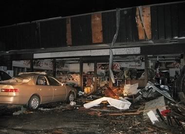
The posts in this forum are NOT official forecast and should not be used as such. They are just the opinion of the poster and may or may not be backed by sound meteorological data. They are NOT endorsed by any professional institution or STORM2K.
Great News. Rotation has weakened, the cell has weakened, the warnings are expired and changed to Severe Thunderstorm Warnings.... for now.
SEVERE WEATHER STATEMENT
NATIONAL WEATHER SERVICE WICHITA KS
242 AM CDT SAT MAY 5 2007
KSC053-159-050752-
/O.EXP.KICT.TO.W.0013.000000T0000Z-070505T0745Z/
ELLSWORTH KS-RICE KS-
242 AM CDT SAT MAY 5 2007
...THE TORNADO WARNING FOR NORTHWESTERN RICE AND SOUTHWESTERN
ELLSWORTH COUNTIES HAS BEEN ALLOWED TO EXPIRE...
AT 241 AM CDT...WEATHER SERVICE DOPPLER RADAR INDICATED THAT THE
THUNDERSTORMS WHICH PROMPTED THE WARNING HAVE MOVED OUT OF THE AREA.
THEREFORE...THE TORNADO WARNING HAS BEEN ALLOWED TO EXPIRE.
A TORNADO WATCH REMAINS IN EFFECT UNTIL 800 AM CDT SATURDAY MORNING
FOR CENTRAL KANSAS.
If the Greensburg tornado lasted this whole time (Which it might have), it would be around 6 hours on the ground. For prespective, the Tri State Tornado was on the ground for 3 and a half hours.
With that, I'm signing off and heading to bed finally. Praying that the damage isn't as bad as feared.
Just finished reading through the thread. It was a long and dangerous night for Kansas. Amazing supercell that just did not quit.
I expect we will see much damage from the tornadoes. The SPC has 24 tornadoes occurred in Kansas. It looks like most of those came from the same supercell.
The following post is NOT an official forecast and should not be used as such. It is just the opinion of the poster and may or may not be backed by sound meteorological data. It is NOT endorsed by any professional institution including storm2k.org For Official Information please refer to the NHC and NWS products.
I took this pic about 5min before it hit Greensburg and around the time the report of the twister was a mile wide. This was truely unbelible to track almost all night long.
Last edited by Weatherfreak14 on Sat May 05, 2007 8:46 am, edited 1 time in total.
I fell asleep around 1 am EDT/midnight CDT. Wow that supercell was like the Energizer bunny - it kept going...and going...and going. That is incredible destruction in Greensburg. It is amazing only one person is dead in that mess.
NROT value just south of Greensburg (at the time of this it was at +3.61....much higher than that Enterprise, AL storm and the Linn County, KS storm earlier in the year):
This is a 3D slice of the rotation in the storm to give an idea of the column that was rotating (this doesn't mean that this is what the tornado looked like....this just means there was a HUGE field of ritation all the way from 35,000 feet to near the surface):
simplykristi wrote:OMG The devastation is unreal in Greensburg. OMG
Kristi... who just woke up after a long night of tracking the storm
I'm hearing the sirens ran for 20 minutes before it hit there. That saved dozens, possibly hundreds, of lives. There is no way you can survive that unprepared...
Not good. One fatality is in Stafford County. I looked at the radars from Category 5 and the tornado that went through Stafford county may have gone right over the farm. That means we may have lost the wheat crop, which of course is no consequence when we are talking people dying. We have no family there anymore, just the leased farm. I would be freaking out if we had family still in the area. My wife has fond memories of going there during the summers to visit the GP's(long gone).
I just woke up a few hours ago and just finished reading the thread. I'm glad I went to bed when I did I would have been up for ever. Was that one tornado or was it multiple? Any official rating yet?
There were several tornadoes. Whether the Greenburg tornado was on the ground the whole time I don't know but wouldn't be suprised. I'd expect this to be at least an EF4