Here is the Link
http://www.nco.ncep.noaa.gov/pmb/nwprod ... loop.shtml
Analysis,Models,Sat Pics of Low in Western Atlantic
Moderator: S2k Moderators
Forum rules

The posts in this forum are NOT official forecasts and should not be used as such. They are just the opinion of the poster and may or may not be backed by sound meteorological data. They are NOT endorsed by any professional institution or STORM2K. For official information, please refer to products from the National Hurricane Center and National Weather Service.
-
webke

- S2K Supporter

- Posts: 290
- Age: 70
- Joined: Sun Sep 05, 2004 12:39 pm
- Location: North Myrtle Beach SC
The 12Z WRF/NAM is out
0 likes
-
Stratusxpeye

- Category 2

- Posts: 686
- Joined: Tue Jun 07, 2005 10:40 am
- Location: Tampa, Florida
- Contact:
The wonderful folks at accuweather have jumped on this and placed it on the main page a link to the article. I hope the nogaps did verify that would be great. My poor grass. Highly doubtful I would say but I can have hope.
http://headlines.accuweather.com/news-s ... &article=2
http://headlines.accuweather.com/news-s ... &article=2
0 likes
-
Weatherfreak14

- Category 5

- Posts: 1381
- Joined: Sat Sep 24, 2005 3:40 pm
- Location: Beaufort, SC
- Contact:

Possible SE Atlantic Hybrid System
This mornings discussion from HPC seems to be rather bullish on cyclonic development off the SE Atlantic Coast. They are relying on the UKMET and Euro for their long range guidance. From the Discussion they indicate that this low pressure may hang around drifting off the Ga-SC coasts thru next weekend.
...SOUTHEAST SEABOARD/W ATLC...
MODELS HAVE FINALLY COME INTO GOOD AGREEMENT FOLLOWING THE SEVERAL
DAY LEAD OF THE UKMET WITH ITS EARLIER AND BETTER DEPICTION OF
CUTOFF LOW DEVELOPMENT OFF THE SOUTHEAST COAST
WITH A WWD DRIFT OF THE MID LEVEL AND SFC LOW BACK TOWARDS THE
SOUTHEAST COAST WED AND THURS. ALL MODELS SHOW GRADUAL MID LEVEL
AND SFC WEAKENING IN TIME BUT ALSO SHOW IT STARTING AS SYMMETRICAL
COLD CORE EVOLVING TO SHALLOW WARM CORE AS IT MOVES WWD. IT WILL
ALSO BE HEADING BACK TOWARDS WARMER GULFSTREAM WATERS. THIS SYSTEM
MAY TAKE ON HYBRID TROPICAL CHARACTERISTICS DEPENDING UPON HOW
MUCH CONVECTION DEVELOPS. WITH LOSS OF STEERING/WEAKENING AND
WARMING MID LEVELS EXPECT LOW MAY JUST DRIFT ALONG WARMER CLOSER
INSHORE GULFSTREAM OFF THE GA/SC COAST.SEE LOCAL OFFICES AND OPC
FORECAST FOR WARNINGS. MONITOR POTENTIAL TPC DISCUSSIONS LATER
THIS WEEK.
STRONG NE WINDS CONTG TUESDAY AND WED CONTG MDT BY THURSDAY LOWER
DELMARVA TO FL. RAIN WILL SPREAD BACK ONSHORE INTO THE NC
OUTERBANKS TUES AND ALONG THE SOUTHEAST COAST TO CENTRAL FL AS FAR
NORTH AS THE LOWER DELMARVA THURSDAY. DEPENDING UPON WHAT
EVOLUTION IT HAS EITHER DECAYING OR BECOMING MORE HYBRID OR BOTH
EXPECT RAIN CHANCES ACROSS AT LEAST COASTAL NC/SC/GA/FL FRI AND
SAT.
0 likes

-
JonathanBelles
- Professional-Met

- Posts: 11430
- Age: 35
- Joined: Sat Dec 24, 2005 9:00 pm
- Location: School: Florida State University (Tallahassee, FL) Home: St. Petersburg, Florida
- Contact:
-
Tampa Bay Hurricane

- Category 5
- Posts: 5597
- Age: 38
- Joined: Fri Jul 22, 2005 7:54 pm
- Location: St. Petersburg, FL
The following post is NOT an official forecast and should not be used as such. It is just the opinion of the poster and may or may not be backed by sound meteorological data. It is NOT endorsed by any professional institution including storm2k.org For Official Information please refer to the NHC and NWS products.
Forecasted Prediction:
Wow. All global model scenarios look to be onto something, I think
develipment is possible, with reduced shear over this area,
a tropical depression is possible especially once this area
moves over the gulf stream.
24 hrs: 15 mph weak low, gusts to 25 mph offshore
48 hours: 25 mph surface low, gusts to 30 mph
offshore Coastal Georgia, Florida
72 hours: 35 mph tropical depression, gusts to 48 mph
offshore coastal Florida, Georgia
96 hours if over water: 50 mph Tropical Storm,
with heavy bands of rain and gusty winds to 70 mph
in stronger thunderstorms offshore coastal Florida
and South Coastal Georgia
120 hours if over water: 60 mph sustained winds, Strong Tropical Storm
Gusts to 80 mph in stronger storms and squalls offshore
144 hours on land: 55 mph sustained, gusts 75 mph intense squalls
Yes! I hope we get a good TD or 40 mph Tropical Storm to bring some rain in here.
This is a blessing! I'm so excited at this prospect for some rain!!!!!
Edit: Euro showing down to 1001 mb, that would likely be a tropical storm
Last edited by Tampa Bay Hurricane on Sat May 05, 2007 11:45 am, edited 2 times in total.
0 likes
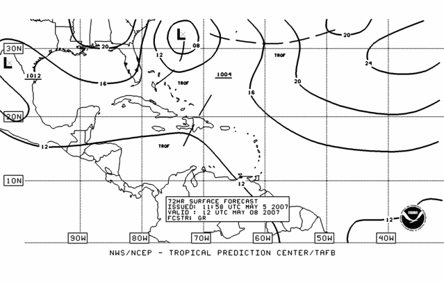
00Z Euro Run
00Z Euro run eventualy weakens the low and brings it into Melbourne and to SW FL by Friday night.
http://weather.cod.edu/forecast/
Hit the ECMWF tab and NA view. Run the 850 mb temp loop from left hand column.
http://weather.cod.edu/forecast/
Hit the ECMWF tab and NA view. Run the 850 mb temp loop from left hand column.
0 likes


-
MississippiHurricane

- ChatStaff

- Posts: 648
- Age: 41
- Joined: Sat Jul 16, 2005 12:20 am
- Location: Hanover, Maryland
- Contact:
-
Weatherfreak14
- Category 5
- Posts: 1381
- Joined: Sat Sep 24, 2005 3:40 pm
- Location: Beaufort, SC
- Contact:
-
cycloneye

- Admin

- Posts: 149276
- Age: 69
- Joined: Thu Oct 10, 2002 10:54 am
- Location: San Juan, Puerto Rico
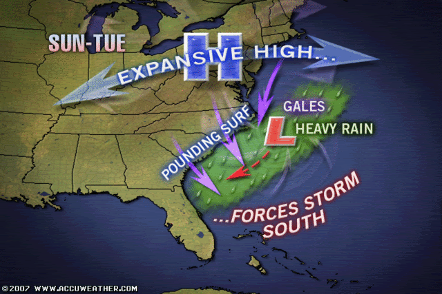
ATLANTIC...
THE MAIN WEATHER FEATURE IN THE WRN ATLC CONTINUES TO BE THE SFC
TROUGH EXTENDING NE FROM HISPANIOLA TO A 1012 MB SFC LOW LOCATED
NEAR 27N64W. THIS...ALONG WITH UPPER DIFFLUENCE BETWEEN AN UPPER
TROUGH OVER THE WRN ATLC AND UPPER RIDGE OVER THE CENTRAL
ATLC...IS SUPPORTING AN EXTENSIVE AREA OF OVERCAST CLOUDINESS
WITH EMBEDDED SHOWERS/ISOLATED TSTMS N OF 24N BETWEEN 52W-65W.
ON THE WESTERN SIDE OF THIS AREA...VIS SAT IMAGERY SHOWS A SWIRL
OF LOW CLOUDS ASSOCIATED WITH THE DEVELOPING SFC LOW. THIS LOW
WILL MOVE MAINLY E WITH LITTLE CHANGE IN THE NEXT 24 HOURS. THE
GLOBAL MODELS ARE ALSO GRADUALLY COMING INTO BETTER AGREEMENT
REGARDING THE DEVELOPMENT OF ANOTHER LOW OFF THE SOUTHEAST U.S.
COAST DURING THE SUN-TUE TIMEFRAME. THIS FEATURE COULD HAVE
SIGNIFICANT MARINE IMPACTS FOR THE AREA INTO EARLY NEXT WEEK.
THIS LOW IS FORECAST TO EVOLVE FROM A STATIONARY FRONTAL
BOUNDARY EXTENDING NOW ALONG 31N WEST OF 60W. THIS SFC LOW MAY
REACH STORM FORCE WINDS AS IT MAKES A LOOPING TYPE MOTION OFF
THE SE US.
http://www.storm2k.org/wx/modules.php?n ... ge&pid=109
From the 2 PM TPC discussion.
0 likes
Visit the Caribbean-Central America Weather Thread where you can find at first post web cams,radars
and observations from Caribbean basin members Click Here
and observations from Caribbean basin members Click Here
-
Tampa Bay Hurricane
- Category 5
- Posts: 5597
- Age: 38
- Joined: Fri Jul 22, 2005 7:54 pm
- Location: St. Petersburg, FL
cycloneye wrote:ATLANTIC...
.....THIS FEATURE COULD HAVE
SIGNIFICANT MARINE IMPACTS FOR THE AREA INTO EARLY NEXT WEEK.
THIS LOW IS FORECAST TO EVOLVE FROM A STATIONARY FRONTAL
BOUNDARY EXTENDING NOW ALONG 31N WEST OF 60W. THIS SFC LOW MAY
REACH STORM FORCE WINDS AS IT MAKES A LOOPING TYPE MOTION OFF
THE SE US.
http://www.storm2k.org/wx/modules.php?n ... ge&pid=109
From the 2 PM TPC discussion.
Folks thats a SURFACE LOW with 55-63 mph Sustained Winds!!!
This could be quite a storm...
obviously if this transitions into a warm core we
have a strong Tropical Storm Andrea on our
hands.
Last edited by Tampa Bay Hurricane on Sat May 05, 2007 1:24 pm, edited 2 times in total.
0 likes
-
cycloneye
- Admin
- Posts: 149276
- Age: 69
- Joined: Thu Oct 10, 2002 10:54 am
- Location: San Juan, Puerto Rico
12z UKMET Loop

The 12z UKMET shows the low deepening but it weakens as it moves closer to the coast.
12z GFS Loop
The 12z GFS has the low depening but not as strong as the UKMET.As it moves towards the Carolinas it weakens.
12z CMC Loop
The 12z Canadian model is more stronger than UKMET but does not move the low towards the coast.
0 likes
Visit the Caribbean-Central America Weather Thread where you can find at first post web cams,radars
and observations from Caribbean basin members Click Here
and observations from Caribbean basin members Click Here
-
Tampa Bay Hurricane
- Category 5
- Posts: 5597
- Age: 38
- Joined: Fri Jul 22, 2005 7:54 pm
- Location: St. Petersburg, FL
-
cycloneye
- Admin
- Posts: 149276
- Age: 69
- Joined: Thu Oct 10, 2002 10:54 am
- Location: San Juan, Puerto Rico
Tampa Bay Hurricane wrote:Cycloneye please tell me if i am reading models correctly:
UKMET takes this system down to 996-1000 mb on the color
graphic
CMC takes this down to 998 mb as well
That would be a moderate tropical storm I believe,
am I correct?
You are correct.However,if this low is of cold core origin that I think it is,this will be a gale low that is a threat to shipping lanes only. But it can transform into a warm core or hybrid low if it gets ideal enviromental conditions.
0 likes
Visit the Caribbean-Central America Weather Thread where you can find at first post web cams,radars
and observations from Caribbean basin members Click Here
and observations from Caribbean basin members Click Here
-
Tampa Bay Hurricane
- Category 5
- Posts: 5597
- Age: 38
- Joined: Fri Jul 22, 2005 7:54 pm
- Location: St. Petersburg, FL
-
cycloneye
- Admin
- Posts: 149276
- Age: 69
- Joined: Thu Oct 10, 2002 10:54 am
- Location: San Juan, Puerto Rico
Tampa Bay Hurricane wrote:Thank you cycloneye for the explanation. One more question:
So basically if it moves over the warmer waters of the gulf stream
and shear lessens around it-- these 2 conditions would
be the ideal environmental conditions that would allow it to transform from cold core
to warm core?
Separate from the upper trough,less shear and marginal sst's and boom,there you go.Also,if invest 90L pops up,that means,they see a chance.But if no invest pops then no-no.
0 likes
Visit the Caribbean-Central America Weather Thread where you can find at first post web cams,radars
and observations from Caribbean basin members Click Here
and observations from Caribbean basin members Click Here
Who is online
Users browsing this forum: No registered users and 205 guests