Tornado on the ground 5 SW of Stafford.
Kristi
Moderate Tornado Risk and High Severe Risk Today
Moderator: S2k Moderators
Forum rules

The posts in this forum are NOT official forecast and should not be used as such. They are just the opinion of the poster and may or may not be backed by sound meteorological data. They are NOT endorsed by any professional institution or STORM2K.
-
simplykristi
- S2K Supporter

- Posts: 1220
- Joined: Sat May 10, 2003 1:59 pm
- Location: Near KCMO
- Contact:
-
JonathanBelles
- Professional-Met

- Posts: 11430
- Age: 35
- Joined: Sat Dec 24, 2005 9:00 pm
- Location: School: Florida State University (Tallahassee, FL) Home: St. Petersburg, Florida
- Contact:

-
simplykristi
- S2K Supporter
- Posts: 1220
- Joined: Sat May 10, 2003 1:59 pm
- Location: Near KCMO
- Contact:
-
CrazyC83
- Professional-Met
- Posts: 34315
- Joined: Tue Mar 07, 2006 11:57 pm
- Location: Deep South, for the first time!
simplykristi wrote:I am sure. Leave the chasing to the professionals.
Definitely on days like this. Split-second decisions are needed along with high-quality radar and scanners. These aren't small funnels from the sky. These are potentially violent, destructive and deadly tornadoes.
Last edited by CrazyC83 on Sat May 05, 2007 5:29 pm, edited 1 time in total.
0 likes

-
simplykristi
- S2K Supporter
- Posts: 1220
- Joined: Sat May 10, 2003 1:59 pm
- Location: Near KCMO
- Contact:
-
MississippiHurricane

- ChatStaff

- Posts: 648
- Age: 41
- Joined: Sat Jul 16, 2005 12:20 am
- Location: Hanover, Maryland
- Contact:
-
Category 5

- Category 5

- Posts: 10074
- Age: 36
- Joined: Sun Feb 11, 2007 10:00 pm
- Location: New Brunswick, NJ
- Contact:
Tornado Warning
TORNADO WARNING
KSC185-052315-
/O.NEW.KDDC.TO.W.0038.070505T2259Z-070505T2315Z/
BULLETIN - EAS ACTIVATION REQUESTED
TORNADO WARNING
NATIONAL WEATHER SERVICE DODGE CITY KS
559 PM CDT SAT MAY 5 2007
THE NATIONAL WEATHER SERVICE IN DODGE CITY HAS ISSUED A
* TORNADO WARNING FOR...
NORTHEASTERN STAFFORD COUNTY IN SOUTH CENTRAL KANSAS.
* UNTIL 615 PM CDT
* AT 556 PM CDT...STORM CHASERS AND WEATHER SPOTTERS REPORTED A
TORNADO OVER EXTREME NORTHEASTERN STAFFORD COUNTY...OR 10 MILES
NORTHEAST OF HUDSON...MOVING NORTHEAST AT 30 MPH.
* LOCATIONS IMPACTED INCLUDE...
RURAL RESIDENCES OF NORTHEASTERN STAFFORD COUNTY.
AT 550 PM STORM CHASERS REPORTED A TORNADO TWO MILES SOUTHEAST OF
HUDSON AT THE CORNER OF 70TH STREET AND 90TH ROAD IN STAFFORD COUNTY.
THE SAFEST PLACE TO BE DURING A TORNADO IS IN A BASEMENT. IF IN A
MOBILE HOME...EVACUATE TO A SUBSTANTIAL STRUCTURE. GET UNDER A
WORKBENCH OR OTHER PIECE OF STURDY FURNITURE. IF NO BASEMENT IS
AVAILABLE...SEEK SHELTER ON THE LOWEST FLOOR OF THE BUILDING IN AN
INTERIOR HALLWAY OR ROOM SUCH AS A CLOSET. USE BLANKETS OR PILLOWS TO
COVER YOUR BODY AND ALWAYS STAY AWAY FROM WINDOWS.
THIS WARNING EXTENDS THE PREVIOUS WARNING ISSUED FOR STAFFORD.
A TORNADO WATCH REMAINS IN EFFECT UNTIL 1000 PM CDT SATURDAY EVENING
FOR SOUTHWESTERN KANSAS.
LAT...LON 3817 9862 3812 9847 3825 9848 3825 9864
$$
GERARD
TORNADO WARNING
KSC185-052315-
/O.NEW.KDDC.TO.W.0038.070505T2259Z-070505T2315Z/
BULLETIN - EAS ACTIVATION REQUESTED
TORNADO WARNING
NATIONAL WEATHER SERVICE DODGE CITY KS
559 PM CDT SAT MAY 5 2007
THE NATIONAL WEATHER SERVICE IN DODGE CITY HAS ISSUED A
* TORNADO WARNING FOR...
NORTHEASTERN STAFFORD COUNTY IN SOUTH CENTRAL KANSAS.
* UNTIL 615 PM CDT
* AT 556 PM CDT...STORM CHASERS AND WEATHER SPOTTERS REPORTED A
TORNADO OVER EXTREME NORTHEASTERN STAFFORD COUNTY...OR 10 MILES
NORTHEAST OF HUDSON...MOVING NORTHEAST AT 30 MPH.
* LOCATIONS IMPACTED INCLUDE...
RURAL RESIDENCES OF NORTHEASTERN STAFFORD COUNTY.
AT 550 PM STORM CHASERS REPORTED A TORNADO TWO MILES SOUTHEAST OF
HUDSON AT THE CORNER OF 70TH STREET AND 90TH ROAD IN STAFFORD COUNTY.
THE SAFEST PLACE TO BE DURING A TORNADO IS IN A BASEMENT. IF IN A
MOBILE HOME...EVACUATE TO A SUBSTANTIAL STRUCTURE. GET UNDER A
WORKBENCH OR OTHER PIECE OF STURDY FURNITURE. IF NO BASEMENT IS
AVAILABLE...SEEK SHELTER ON THE LOWEST FLOOR OF THE BUILDING IN AN
INTERIOR HALLWAY OR ROOM SUCH AS A CLOSET. USE BLANKETS OR PILLOWS TO
COVER YOUR BODY AND ALWAYS STAY AWAY FROM WINDOWS.
THIS WARNING EXTENDS THE PREVIOUS WARNING ISSUED FOR STAFFORD.
A TORNADO WATCH REMAINS IN EFFECT UNTIL 1000 PM CDT SATURDAY EVENING
FOR SOUTHWESTERN KANSAS.
LAT...LON 3817 9862 3812 9847 3825 9848 3825 9864
$$
GERARD
0 likes

-
brunota2003

- S2K Supporter
- Posts: 9476
- Age: 35
- Joined: Sat Jul 30, 2005 9:56 pm
- Location: Stanton, KY...formerly Havelock, NC
- Contact:
BULLETIN - EAS ACTIVATION REQUESTED
TORNADO WARNING
NATIONAL WEATHER SERVICE DODGE CITY KS
613 PM CDT SAT MAY 5 2007
THE NATIONAL WEATHER SERVICE IN DODGE CITY HAS ISSUED A
* TORNADO WARNING FOR...
EASTERN PAWNEE COUNTY IN SOUTH CENTRAL KANSAS.
* UNTIL 645 PM CDT
* AT 612 PM CDT...NATIONAL WEATHER SERVICE DOPPLER RADAR INDICATED AND
A STORM CHASER REPORTED A TORNADO 2 MILES NORTHEAST OF BELPRE...MOVING
NORTHEAST AT 35 MPH.
* LOCATIONS IMPACTED INCLUDE...
ZOOK...
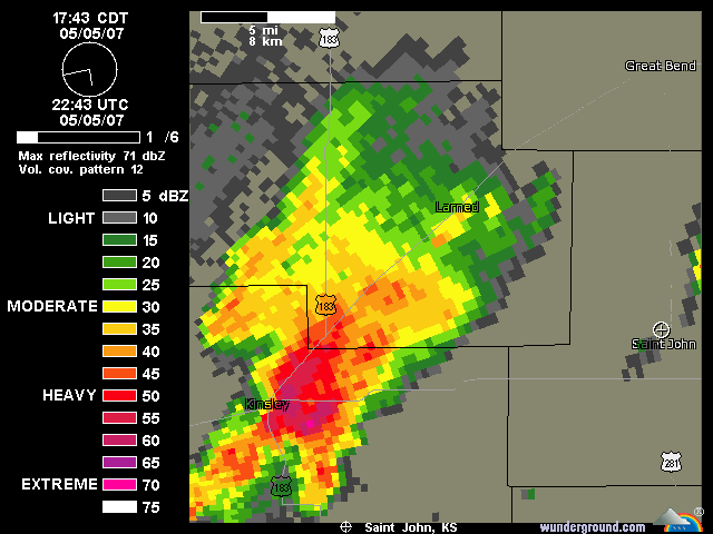
LARNED...
RURAL RESIDENCES OF EASTERN PAWNEE COUNTY.
THIS INCLUDES HIGHWAY 56 BETWEEN MILE MARKERS 171 AND 187.
(does anyone have tornado-be-gone? I'll be danged if I see damage reports from Larned...)
...A TORNADO WARNING REMAINS IN EFFECT UNTIL 645 PM CDT FOR EASTERN
PAWNEE COUNTY...
AT 621 PM CDT...NATIONAL WEATHER SERVICE DOPPLER RADAR CONTINUED TO
INDICATE A POSSIBLE TORNADO. THIS TORNADO WAS LOCATED 6 MILES
SOUTH OF LARNED...MOVING NORTHEAST AT 35 MPH.
* LOCATIONS IMPACTED INCLUDE...
LARNED...
RURAL RESIDENCES OF EASTERN PAWNEE COUNTY.
THIS INCLUDES HIGHWAY 56 BETWEEN MILE MARKERS 171 AND 187.
AT 620 PM STORM SPOTTERS HAD REPORTED SEVERAL FUNNEL CLOUDS 6 MILES
SOUTH OF LARNED. IN ADDITION TO THE TORNADO...THIS STORM IS CAPABLE
OF PRODUCING BASEBALL SIZE HAIL AND DESTRUCTIVE STRAIGHT LINE WINDS.
TORNADO WARNING
NATIONAL WEATHER SERVICE DODGE CITY KS
613 PM CDT SAT MAY 5 2007
THE NATIONAL WEATHER SERVICE IN DODGE CITY HAS ISSUED A
* TORNADO WARNING FOR...
EASTERN PAWNEE COUNTY IN SOUTH CENTRAL KANSAS.
* UNTIL 645 PM CDT
* AT 612 PM CDT...NATIONAL WEATHER SERVICE DOPPLER RADAR INDICATED AND
A STORM CHASER REPORTED A TORNADO 2 MILES NORTHEAST OF BELPRE...MOVING
NORTHEAST AT 35 MPH.
* LOCATIONS IMPACTED INCLUDE...
ZOOK...
LARNED...
RURAL RESIDENCES OF EASTERN PAWNEE COUNTY.
THIS INCLUDES HIGHWAY 56 BETWEEN MILE MARKERS 171 AND 187.
(does anyone have tornado-be-gone? I'll be danged if I see damage reports from Larned...)
...A TORNADO WARNING REMAINS IN EFFECT UNTIL 645 PM CDT FOR EASTERN
PAWNEE COUNTY...
AT 621 PM CDT...NATIONAL WEATHER SERVICE DOPPLER RADAR CONTINUED TO
INDICATE A POSSIBLE TORNADO. THIS TORNADO WAS LOCATED 6 MILES
SOUTH OF LARNED...MOVING NORTHEAST AT 35 MPH.
* LOCATIONS IMPACTED INCLUDE...
LARNED...
RURAL RESIDENCES OF EASTERN PAWNEE COUNTY.
THIS INCLUDES HIGHWAY 56 BETWEEN MILE MARKERS 171 AND 187.
AT 620 PM STORM SPOTTERS HAD REPORTED SEVERAL FUNNEL CLOUDS 6 MILES
SOUTH OF LARNED. IN ADDITION TO THE TORNADO...THIS STORM IS CAPABLE
OF PRODUCING BASEBALL SIZE HAIL AND DESTRUCTIVE STRAIGHT LINE WINDS.
0 likes
-
MississippiHurricane
- ChatStaff
- Posts: 648
- Age: 41
- Joined: Sat Jul 16, 2005 12:20 am
- Location: Hanover, Maryland
- Contact:
-
CrazyC83
- Professional-Met
- Posts: 34315
- Joined: Tue Mar 07, 2006 11:57 pm
- Location: Deep South, for the first time!
SEVERE WEATHER STATEMENT
NATIONAL WEATHER SERVICE WICHITA KS
700 PM CDT SAT MAY 5 2007
KSC009-060015-
/O.CON.KICT.TO.W.0016.000000T0000Z-070506T0015Z/
BARTON KS-
700 PM CDT SAT MAY 5 2007
...A TORNADO WARNING REMAINS IN EFFECT FOR SOUTHERN BARTON COUNTY
UNTIL 715 PM CDT...
***A TORNADO EMERGENCY FOR GREAT BEND***
AT 658 PM CDT...TRAINED WEATHER SPOTTERS REPORTED A TORNADO. THIS
TORNADO WAS LOCATED NEAR GREAT BEND...MOVING NORTHEAST AT 35 MPH.
THIS TORNADO WILL AFFECT MAINLY RURAL AREAS OF SOUTHERN BARTON
COUNTY...INCLUDING THE TOWN OF GREAT BEND.
THIS IS AN EXTREMELY DANGEROUS AND LIFE THREATENING SITUATION. THIS
STORM IS CAPABLE OF PRODUCING STRONG TO VIOLENT TORNADOES. IF YOU ARE
IN THE PATH OF THIS TORNADO...TAKE COVER IMMEDIATELY!
A TORNADO WATCH REMAINS IN EFFECT UNTIL 1000 PM CDT SATURDAY EVENING
FOR SOUTH CENTRAL KANSAS.
LAT...LON 3851 9904 3825 9903 3825 9848 3851 9847
$$
KETCHAM
0 likes
-
simplykristi
- S2K Supporter
- Posts: 1220
- Joined: Sat May 10, 2003 1:59 pm
- Location: Near KCMO
- Contact:
-
simplykristi
- S2K Supporter
- Posts: 1220
- Joined: Sat May 10, 2003 1:59 pm
- Location: Near KCMO
- Contact:
-
JonathanBelles
- Professional-Met
- Posts: 11430
- Age: 35
- Joined: Sat Dec 24, 2005 9:00 pm
- Location: School: Florida State University (Tallahassee, FL) Home: St. Petersburg, Florida
- Contact:
Return to “USA & Caribbean Weather”
Who is online
Users browsing this forum: txtwister78 and 161 guests