Analysis,Models,Sat Pics of Low in Western Atlantic
Moderator: S2k Moderators
Forum rules

The posts in this forum are NOT official forecasts and should not be used as such. They are just the opinion of the poster and may or may not be backed by sound meteorological data. They are NOT endorsed by any professional institution or STORM2K. For official information, please refer to products from the National Hurricane Center and National Weather Service.
-
Opal storm


Buoy 41001 - 150 NM east of Cape Hatteras - 9 PM
Wind Direction (WDIR): NNE ( 20 deg true )
Wind Speed (WSPD): 40.8 kts
Wind Gust (GST): 56.3 kts
Wave Height (WVHT): 27.6 ft
Dominant Wave Period (DPD): 13 sec
Average Period (APD): 9.2 sec
Atmospheric Pressure (PRES): 29.77 in
Pressure Tendency (PTDY): -0.05 in ( Falling )
Air Temperature (ATMP): 59.5 °F
Water Temperature (WTMP): 67.3 °F
Dew Point (DEWP): 55.0 °F
0 likes
-
johngaltfla

- Category 5

- Posts: 2073
- Joined: Sun Jul 10, 2005 9:17 pm
- Location: Sarasota County, FL
- Contact:
remember the tax day nor'easter down to 968 millibars but NO high pressure above it kept winds to the north in the 40-50 mph zone while western side of storm was about 50 mph and gusted over 70mph because there was a modest high pressure further out in the plains
the big high to the north of this storm is wedging down pretty far i think the winds on this baby ( the barcolonic forcing?) will be cranking around the north and west sides with winds sustained 55- 60 mph by morning (just offshore) currently east hatteras bouy is SUSTAINED at 47 mph with gusts to 65 mph and 27 foot seas!
huge swells being sent down to palm beach florida i am going out late tomorrow and tuesday to shoot some footage probably 12 foot swells with 18 foot seas in gulf stream off shore (last time it got that big in the palm beaches was slot swell in isabel in delray beach 15 feet) and before that was the perfect strom 16 feet sets ( from the breakers down to lake worth '91) the beauty/power of the ocean is something to behold
Last edited by cpdaman on Sun May 06, 2007 8:38 pm, edited 2 times in total.
0 likes
-
meteorologyman
- Category 2

- Posts: 541
- Joined: Wed Mar 15, 2006 6:48 pm
- Location: Florida, Kissimmee/St.CLoud
I hate it when I'm out of town working, I always seem to miss a lot
here is the forecast of the forming low
12 hours
http://weather.unisys.com/hurricane/slp_12.gif
shear
http://weather.unisys.com/hurricane/shr_12.gif
24 hours
http://weather.unisys.com/hurricane/slp_24.gif
shear
http://weather.unisys.com/hurricane/shr_24.gif
48 hours
http://weather.unisys.com/hurricane/slp_48.gif
shear
http://weather.unisys.com/hurricane/shr_48.gif
Looks like its heading for Fl then into Gulf
More data Big Page
http://www.crownweather.com/tropical.html
http://www.crownweather.com/tropical.html
0 likes
-
Extremeweatherguy

- Category 5
- Posts: 11095
- Joined: Mon Oct 10, 2005 8:13 pm
- Location: Florida
-
HurricaneHunter914
- Category 5
- Posts: 4439
- Age: 32
- Joined: Fri Mar 10, 2006 7:36 pm
- Location: College Station, TX
Looks like rain is on it's way to Florida over the next couple of days and maybe the possibility of being TD#1.
Edit:http://www.ssd.noaa.gov/PS/TROP/DATA/RT/SST/ATL/20.jpg
The SSTs are above normal for this time of year especially in the gulf stream where are little system is.
Edit:http://www.ssd.noaa.gov/PS/TROP/DATA/RT/SST/ATL/20.jpg
The SSTs are above normal for this time of year especially in the gulf stream where are little system is.
0 likes
Personal Forecast Disclaimer:
The posts in this forum are NOT official forecast and should not be used as such. They are just the opinion of the poster and may or may not be backed by sound meteorological data. They are NOT endorsed by any professional institution or storm2k.org. For official information, please refer to the NHC and NWS products.
The posts in this forum are NOT official forecast and should not be used as such. They are just the opinion of the poster and may or may not be backed by sound meteorological data. They are NOT endorsed by any professional institution or storm2k.org. For official information, please refer to the NHC and NWS products.
-
Stormavoider
- Category 2
- Posts: 671
- Joined: Sat Jul 01, 2006 4:37 pm
- Location: Spring Hill Fl.


It will be another good 24-36 hrs before this system has a chance to become subtropical, right now it is a good example of an extratropical or frontal low pressure system. Best chances of it becoming somewhat tropical or subtropical will be 36-84 hrs from now.
By the way, the North Carolina's immidiate coast feel anything but not even to a subtropical conditions this evening, feels more like a late winter Atlantic storm's condition, with temps in the low 50s and windchills all the way down to the low 30s with the wind gusts, dewpoints all the way down to the 20s and 30s.
By the way, the North Carolina's immidiate coast feel anything but not even to a subtropical conditions this evening, feels more like a late winter Atlantic storm's condition, with temps in the low 50s and windchills all the way down to the low 30s with the wind gusts, dewpoints all the way down to the 20s and 30s.
0 likes


I found this and believe that could be interesting for some of us. Keep relation to this low area that we are watching.
Sub-tropical cyclones are defined as nonfrontal
low pressure systems comprising initial coldcore
(baroclinic) circulations which develop over
sub-tropical waters (Hebert & Poteat 1975). This
can occur when cold lows cut off near 200 mb and
when upper air troughs extend from the mid-latitudes
into the tropics. Chaston (1988) found that about
14 % of all cut-off lows develop near Cape Hatteras,
North Carolina, and can persist for up to 2 wk. Also,
remnants of a polar front can induce convection and
occasionally generate a sub-tropical cyclone, especially
when sufficient upper-air venting is evident
(Lewis & Hsu 1992).
0 likes
-
eastcoastFL

- Category 5
- Posts: 3996
- Age: 44
- Joined: Thu Apr 12, 2007 12:29 pm
- Location: Palm City, FL
I am getting excited about the possibility of having a storm we could sure use the rain and I was already getting excited about the season being so close
0 likes
Personal Forecast Disclaimer:
The posts in this forum are NOT official forecast and should not be used as such. They are just the opinion of the poster and may or may not be backed by sound meteorological data. They are NOT endorsed by any professional institution or storm2k.org. For official information, please refer to the NHC and NWS products.
The posts in this forum are NOT official forecast and should not be used as such. They are just the opinion of the poster and may or may not be backed by sound meteorological data. They are NOT endorsed by any professional institution or storm2k.org. For official information, please refer to the NHC and NWS products.
-
MusicCityMan

- Category 1

- Posts: 483
- Joined: Sat Feb 17, 2007 10:57 pm
- Location: Somewhere in Central Florida
-
'CaneFreak

- Category 5
- Posts: 1487
- Joined: Mon Jun 05, 2006 10:50 am
- Location: New Bern, NC
We don't have a wanna be Andrea going on....for anyone who says tropical cyclone formation is possible....I hate to break the bad news...but, SSTs are WELL BELOW 80 degrees where this thing is sitting...so unfortunately...this thing will not make it to tropical characteristics....even if it creeps into the Gulf...SSTs in the gulf are barely sustainable for anything to develop....this thing MAY make it to subtropical...but I really and truly dont think it will for various reasons.
SSTS
http://www.meteo.psu.edu/~gadomski/SATA ... ecent.html
SSTS
http://www.meteo.psu.edu/~gadomski/SATA ... ecent.html
0 likes
-
Noles2006

- Category 1
- Posts: 424
- Joined: Thu Jun 08, 2006 9:57 am
- Location: Tallahassee, Florida
- Contact:
'CaneFreak wrote:We don't have a wanna be Andrea going on....for anyone who says tropical cyclone formation is possible....I hate to break the bad news...but, SSTs are WELL BELOW 80 degrees where this thing is sitting...so unfortunately...this thing will not make it to tropical characteristics....even if it creeps into the Gulf...SSTs in the gulf are barely sustainable for anything to develop....this thing MAY make it to subtropical...but I really and truly dont think it will for various reasons.
SSTS
http://www.meteo.psu.edu/~gadomski/SATA ... ecent.html
Cool SSTs sure didn't hurt those late season storms in 05...
0 likes
-
'CaneFreak
- Category 5
- Posts: 1487
- Joined: Mon Jun 05, 2006 10:50 am
- Location: New Bern, NC
'CaneFreak wrote:We don't have a wanna be Andrea going on....for anyone who says tropical cyclone formation is possible....I hate to break the bad news...but, SSTs are WELL BELOW 80 degrees where this thing is sitting...so unfortunately...this thing will not make it to tropical characteristics....even if it creeps into the Gulf...SSTs in the gulf are barely sustainable for anything to develop....this thing MAY make it to subtropical...but I really and truly dont think it will for various reasons.
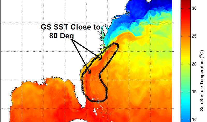
I don't think anybody has said that it will gain subtropical charecteristics where it is sitting right now, the possibilities come once it moves closer and over the gulf stream where SST are close to 80 deg. Even upper 70s are good enough for a subtropical system to form, it has happened many times over the Atlantic. I think the killer would be if it moves westward a lot faster through the warmer waters thus sucking some of the dry air coming down the Carolinas coast.
By the way here's a more accurate SST map than the one you posted, I posted this earlier today, I pointed out areas where water temps are close to 80 deg F.
Last edited by NDG on Sun May 06, 2007 10:52 pm, edited 1 time in total.
0 likes

Who is online
Users browsing this forum: gib and 118 guests