Analysis,Models,Sat Pics of Low in Western Atlantic

This is the general tropical discussion area. Anyone can take their shot at predicting a storms path.

Moderator: S2k Moderators

Forum rules

The posts in this forum are NOT official forecasts and should not be used as such. They are just the opinion of the poster and may or may not be backed by sound meteorological data. They are NOT endorsed by any professional institution or STORM2K. For official information, please refer to products from the National Hurricane Center and National Weather Service.

Help Support Storm2K
Message
Author
User avatar
HURAKAN
Professional-Met
Professional-Met
Posts: 46086
Age: 38
Joined: Thu May 20, 2004 4:34 pm
Location: Key West, FL
Contact:

#281 Postby HURAKAN » Mon May 07, 2007 12:11 pm

Image

The storm is really big!!!
0 likes   

User avatar
HURAKAN
Professional-Met
Professional-Met
Posts: 46086
Age: 38
Joined: Thu May 20, 2004 4:34 pm
Location: Key West, FL
Contact:

#282 Postby HURAKAN » Mon May 07, 2007 12:13 pm

Stormavoider wrote:I like this loop. Don't click if you are on dial-up.
nasa


Yes, looks really cool. Lets see if thunderstorm activity can develop over the center.
0 likes   

User avatar
cycloneye
Admin
Admin
Posts: 145285
Age: 68
Joined: Thu Oct 10, 2002 10:54 am
Location: San Juan, Puerto Rico

#283 Postby cycloneye » Mon May 07, 2007 12:32 pm

kevin wrote:In the nhc satellite page, it says above floater 4 "Subtropical System"


Yup.Here is the link to the Floaters page.

http://www.ssd.noaa.gov/PS/TROP/floaters.html
0 likes   
Visit the Caribbean-Central America Weather Thread where you can find at first post web cams,radars
and observations from Caribbean basin members Click Here

User avatar
Damar91
Category 2
Category 2
Posts: 551
Joined: Wed Aug 24, 2005 1:06 pm
Location: Coral Springs, FL

#284 Postby Damar91 » Mon May 07, 2007 12:49 pm

The last couple of hours or so seem to show a little bit more shower activity near the "center". Also seems to be detaching itself from the "arm" of the low. Just an observation.
0 likes   

JonathanBelles
Professional-Met
Professional-Met
Posts: 11430
Age: 35
Joined: Sat Dec 24, 2005 9:00 pm
Location: School: Florida State University (Tallahassee, FL) Home: St. Petersburg, Florida
Contact:

#285 Postby JonathanBelles » Mon May 07, 2007 12:58 pm

Wow it looks better compared to this morning.
0 likes   

User avatar
HURAKAN
Professional-Met
Professional-Met
Posts: 46086
Age: 38
Joined: Thu May 20, 2004 4:34 pm
Location: Key West, FL
Contact:

#286 Postby HURAKAN » Mon May 07, 2007 1:02 pm

TWD 2:05 PM
WESTERN ATLANTIC...
ATTENTION REMAINS FOCUSED ON A RAPIDLY STRENGTHENING LOW PRES
CENTER OFF THE SE OF UNITED STATES. A 998 MB LOW IS ANALYZED ON
THE 12Z MAP NEAR 32N73W. THIS STRONG LOW WILL MOVE INTO OUR
FORECAST AREA LATER THIS AFTERNOON. THE BACK DOOR COLD FRONT
ASSOCIATED WITH IT ENTERS THE AREA NEAR 31N38W THEN CONTINUES SW
CROSSING THE CENTRAL BAHAMAS AND THE STRAITS OF FLORIDA INTO THE
GULF OF MEXICO. LATEST VIS SAT IMAGERY SHOWS THE LEADING EDGE OF
THE FRONTAL BOUNDARY OVER W-CENTRAL CUBA. CURRENTLY...THE MAIN
IMPACT WITH THIS STORM SYSTEM IS THE STRONG WINDS AND LARGE SEAS
AS A VERY TIGHT PRES GRADIENT HAS SET UP BETWEEN THE LOW AND
STRONG HIGH PRES OVER THE MID-ATLANTIC STATES. SEVERAL ADVISORIES
AND WATCHES/WARNINGS HAVE BEEN POSTED ALONG THE COAST FROM SOUTH
FLORIDA TO BEYOND THE CAROLINAS WHERE ROUGH SURF AND VERY
DANGEROUS RIP CURRENTS ARE EXPECTED. AS THE LOW APPROACHES THE
SE COAST OF U.S. TUE THROUGH WED...RAINFALL WILL BE ALSO A
CONCERN. FOR MORE DETAILS...SEE STATEMENTS FROM LOCAL FORECAST
OFFICES.

http://www.nhc.noaa.gov/text/refresh/MI ... 1746.shtml?
0 likes   

User avatar
MusicCityMan
Category 1
Category 1
Posts: 483
Joined: Sat Feb 17, 2007 10:57 pm
Location: Somewhere in Central Florida

#287 Postby MusicCityMan » Mon May 07, 2007 1:05 pm

Maybe it'll gain some subtropical characteristics and earn itself a name.. That'd put the season into overtime as it would start early :wink:
0 likes   

User avatar
cycloneye
Admin
Admin
Posts: 145285
Age: 68
Joined: Thu Oct 10, 2002 10:54 am
Location: San Juan, Puerto Rico

#288 Postby cycloneye » Mon May 07, 2007 1:16 pm

07/1745 UTC 31.6N 73.9W ST2.5/2.5 90L -- Atlantic Ocean

http://www.ssd.noaa.gov/PS/TROP/positions.html

This afternoon's dvorak T Number update.
0 likes   
Visit the Caribbean-Central America Weather Thread where you can find at first post web cams,radars
and observations from Caribbean basin members Click Here

Coredesat

#289 Postby Coredesat » Mon May 07, 2007 1:22 pm

I should note that those are Herbert-Poteat numbers, not Dvorak numbers. :P

The system is still extratropical, but it does look a lot better. Perhaps I will be eating crow (though perhaps not, because I said this would not do anything for a couple days, and it isn't subtropical yet). :P
0 likes   

User avatar
skysummit
S2K Supporter
S2K Supporter
Posts: 5305
Age: 49
Joined: Tue Aug 31, 2004 11:09 pm
Location: Ponchatoula, LA
Contact:

#290 Postby skysummit » Mon May 07, 2007 1:26 pm

Poor thing is like an oasis in a desert.

Image
0 likes   

Patrick99
Category 5
Category 5
Posts: 1770
Joined: Mon May 24, 2004 3:43 pm
Location: SW Broward, FL

#291 Postby Patrick99 » Mon May 07, 2007 1:34 pm

Funny, it's an impressive looking storm, but there's just not a lot of "weather" associated with it....
0 likes   

User avatar
PerfectStorm
Tropical Depression
Tropical Depression
Posts: 85
Joined: Tue Sep 09, 2003 4:39 pm

#292 Postby PerfectStorm » Mon May 07, 2007 1:36 pm

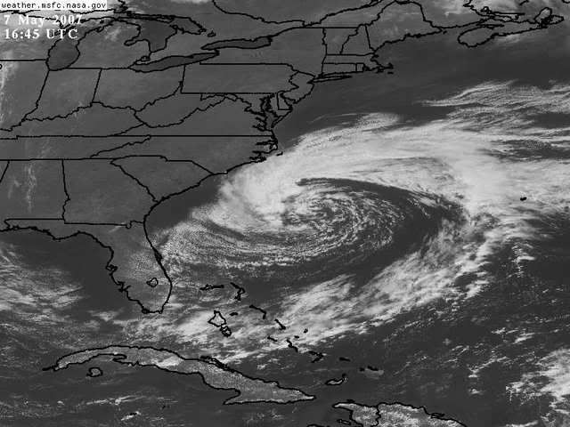
http://www.srh.noaa.gov/wwamap/wwatxtge ... %20warning

Interesting Hurricane Wind Warning for offshore area east of SC/NC Gulfstream Waters.
ANZ086-072030-
HATTERAS CANYON TO CAPE FEAR OUT TO 34N 71W TO 32N 73W
1030 AM EDT MON MAY 7 2007

...HURRICANE FORCE WIND WARNING...

...N WALL OF GULF STREAM NEAR 33.3N 76.7W...33.7N 76.6W...35N
75.3W...

.THIS AFTERNOON...N TO NE WINDS 40 TO 55 KT...EXCEPT 55 TO 70 KT
FROM THE GULF STREAM E EARLY...DIMINISHING TO 35 TO 45 KT
LATE...EXCEPT 45 TO 60 KT NEAR THE GULF STREAM. SEAS 14 TO 24
FT...EXCEPT 24 TO 38 FT FROM THE GULF STREAM E. SCATTERED
SHOWERS AND TSTMS OCCASIONALLY REDUCING VSBY BELOW 1 NM.
.TONIGHT...E TO NE WINDS DIMINISHING TO 25 TO 35 KT
LATE...EXCEPT TO 35 TO 45 KT FROM THE GULF STREAM W. SEAS
BECOMING 18 TO 28 FT... HIGHEST NEAR THE GULF STREAM. SCATTERED
SHOWERS AND TSTMS.
.TUE...WINDS BECOMING E TO NE 25 TO 35 KT THROUGHOUT...HIGHEST
SW. SEAS SUBSIDING TO 13 TO 18 FT...HIGHEST SW NEAR THE GULF
STREAM. SCATTERED SHOWERS AND TSTMS.
.TUE NIGHT...E TO NE WINDS DIMINISHING TO 20 TO 30 KT...HIGHEST
SW. SEAS SUBSIDING TO 10 TO 16 FT...HIGHEST SW NEAR THE GULF
STREAM. SCATTERED SHOWERS AND TSTMS.
.WED...WINDS DIMINISHING TO E TO SE 15 TO 20 KT THROUGHOUT. SEAS
SUBSIDING TO 7 TO 10 FT...HIGHEST W.
.THU...E TO SE WINDS DIMINISHING TO 10 TO 15 KT. SEAS SUBSIDING
TO 4 TO 6 FT LATE.
.FRI...SE WINDS 10 KT OR LESS. SEAS SUBSIDING TO 3 TO 4 FT.
$$
0 likes   

Coredesat

#293 Postby Coredesat » Mon May 07, 2007 1:39 pm

Again, due to the tight pressure gradient. Looks like the winds will subside as the low moves away from the ridge.
0 likes   

User avatar
Fego
S2K Supporter
S2K Supporter
Posts: 767
Age: 65
Joined: Sun Apr 18, 2004 7:58 pm
Location: San Juan, Puerto Rico
Contact:

#294 Postby Fego » Mon May 07, 2007 1:56 pm

Why it is a subtropical system?
0 likes   
Go Giants! Go Niners! Go Warriors!

User avatar
MusicCityMan
Category 1
Category 1
Posts: 483
Joined: Sat Feb 17, 2007 10:57 pm
Location: Somewhere in Central Florida

#295 Postby MusicCityMan » Mon May 07, 2007 2:03 pm

Because it has some subtropical characteristics I would guess? lol
0 likes   

User avatar
Thunder44
Category 5
Category 5
Posts: 5922
Age: 44
Joined: Mon Jun 09, 2003 7:53 pm
Location: New York City

#296 Postby Thunder44 » Mon May 07, 2007 2:08 pm

Take look at this image taken earlier from NOAA. They are also calling this a "subtropical cyclone":

http://www.osei.noaa.gov/OSEIiod.html
0 likes   

User avatar
hial2
S2K Supporter
S2K Supporter
Posts: 809
Joined: Fri Oct 10, 2003 9:20 pm
Location: Indian trail N.C.

#297 Postby hial2 » Mon May 07, 2007 2:29 pm


Can the smoke from the Georgia fires affect the system????
0 likes   

User avatar
hawkeh
Tropical Storm
Tropical Storm
Posts: 109
Joined: Thu Sep 09, 2004 7:35 pm
Location: Bahamas

#298 Postby hawkeh » Mon May 07, 2007 2:35 pm

Should be interesting down here tomorrow. Got the day off to go surfing, there calling for double to triple overhead :eek:

I'll take some pictures for sure.
0 likes   

User avatar
Thunder44
Category 5
Category 5
Posts: 5922
Age: 44
Joined: Mon Jun 09, 2003 7:53 pm
Location: New York City

#299 Postby Thunder44 » Mon May 07, 2007 2:41 pm

hial2 wrote:


Can the smoke from the Georgia fires affect the system????


I don't think so.
0 likes   

Opal storm

#300 Postby Opal storm » Mon May 07, 2007 3:02 pm

jdray wrote:Any bets on how long till we have Andrea?
Not anytime soon.

This thing is just a swirl of dry air.I don't think it will have time to become anything before going inland over FL/GA.
0 likes   


Return to “Talkin' Tropics”

Who is online

Users browsing this forum: No registered users and 38 guests