Remnants of Andrea-Thread 2
Moderator: S2k Moderators
Forum rules

The posts in this forum are NOT official forecasts and should not be used as such. They are just the opinion of the poster and may or may not be backed by sound meteorological data. They are NOT endorsed by any professional institution or STORM2K. For official information, please refer to products from the National Hurricane Center and National Weather Service.

-
Stratosphere747
- Category 5

- Posts: 3772
- Joined: Thu Sep 11, 2003 8:34 pm
- Location: Surfside Beach/Freeport Tx
- Contact:

-
HURAKAN

- Professional-Met

- Posts: 46086
- Age: 38
- Joined: Thu May 20, 2004 4:34 pm
- Location: Key West, FL
- Contact:
http://s40.photobucket.com/albums/e244/ ... c8c3c6.pbr
Another Andrea's pix remix. Music more festive!!!
Another Andrea's pix remix. Music more festive!!!
0 likes

-
Matt-hurricanewatcher
Gfdl takes it almost due east or east-southeast now, many other models take it southwestward then move it around. If the overall shear stays low, would not be suprized to see it once it moves southward into warmer water, to strengthen. But yeah shear should increase.
Also convection is on the interest. The overall center is around 30.5/79.8 or so. The LLC at least the defined on is moving around its base to the east. Which is near the southern convection area.
Also convection is on the interest. The overall center is around 30.5/79.8 or so. The LLC at least the defined on is moving around its base to the east. Which is near the southern convection area.
0 likes
-
Extremeweatherguy

- Category 5
- Posts: 11095
- Joined: Mon Oct 10, 2005 8:13 pm
- Location: Florida
At this point, I would not be surprised by anything that happens with Andrea. My feeling is that she will likely weaken and be a thing of the past soon, but I wouldn't be shocked if it hung around for awhile. One thing that interests me most this evening is the model runs..

The SHIPS model is forecasting Andrea to reach 65mph in 5 days! What's up with that? The craziest thing though would be if the NOGAPS or BAM was right and it worked into the GOM.
The SHIPS model is forecasting Andrea to reach 65mph in 5 days! What's up with that? The craziest thing though would be if the NOGAPS or BAM was right and it worked into the GOM.
0 likes

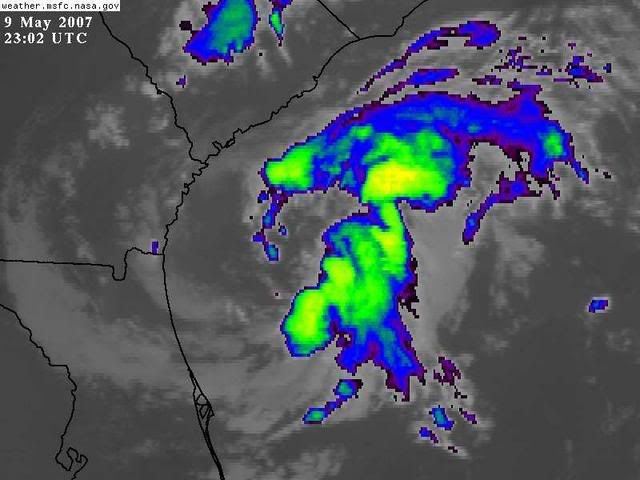
Andrea has some banding to the S and SE this evening.
0 likes
The following post is NOT an official forecast and should not be used as such. It is just the opinion of the poster and may or may not be backed by sound meteorological data. It is NOT endorsed by any professional institution including storm2k.org For Official Information please refer to the NHC and NWS products.

i hope it drifts SE and sends some more waves to palm beach
as well as some rain
model spread looks intresting (all over the place) which shows the steering current are non existant
i'm gonna try to put up a SST plot w/ andrea over it, btw i'm slow w/ graphics so if anyone would like to beat me to it
as well as some rain
model spread looks intresting (all over the place) which shows the steering current are non existant
i'm gonna try to put up a SST plot w/ andrea over it, btw i'm slow w/ graphics so if anyone would like to beat me to it
0 likes
-
MusicCityMan

- Category 1

- Posts: 483
- Joined: Sat Feb 17, 2007 10:57 pm
- Location: Somewhere in Central Florida
-
Opal storm
There is so much shear and dry air in the Gulf right now, that is almost out of the question.Also I heard Jim Canote talking about a storm system that will come from the west and help push this thing back out into the Atlantic. I don't think Andrea will be around much longer.Extremeweatherguy wrote:
The SHIPS model is forecasting Andrea to reach 65mph in 5 days! What's up with that? The craziest thing though would be if the NOGAPS or BAM was right and it worked into the GOM.
0 likes


MODIS has a real nice sat shot of Andrea here w/HI Res available...
http://rapidfire.sci.gsfc.nasa.gov/gall ... 00.2km.jpg

http://rapidfire.sci.gsfc.nasa.gov/gall ... 00.2km.jpg
0 likes
-
cycloneye

- Admin

- Posts: 148753
- Age: 69
- Joined: Thu Oct 10, 2002 10:54 am
- Location: San Juan, Puerto Rico
SPECIAL FEATURE...
SUBTROPICAL STORM ANDREA IS CENTERED NEAR 30.5N 79.5W AT 10/0000
UTC OR 110 MILES SE OF SAVANNAH GEORGIA. ANDREA HAS BEEN
MEANDERING DURING THE PAST FEW HOURS. ESTIMATED MINIMUM CENTRAL
PRESSURE IS 1003 MB. MAXIMUM SUSTAINED WIND SPEED IS 40 KT WITH
GUSTS TO 50 KT. SEE THE LATEST NHC FORECAST/ADVISORY UNDER
AWIPS/WMO HEADERS MIATCMAT1/ WTNT21 KNHC FOR MORE DETAILS.
CONVECTION ASSOCIATED WITH THE RATHER LARGE SLOPPY CIRCULATION
OF ANDREA HAS GENERALLY BEEN ON THE DECLINE FOR MUCH OF THE
DAY...ESPECIALLY OVER THE NW QUADRANT. MOSAIC DOPPLER RADAR FROM
THE SOUTHEAST SHOWS NARROW BROKEN BANDS OF SHOWERS AND
ISOLATED TSTMS ONSHORE AND OVER THE COASTAL WATERS.
HOWEVER...OVER THE PAST FEW HOURS AN IMPROVED WIDER BAND OF
CONVECTION HAS TAKEN SHAPE IN THE ERN SEMICIRCLE. THE SYSTEM IS
LOCATED IN WEAK STEERING AND HAS BEEN SLOWLY DRIFTING THROUGHOUT
THE DAY.
http://www.storm2k.org/wx/modules.php?n ... ge&pid=109
TPC 8 PM Special Feature discussion.
0 likes
Visit the Caribbean-Central America Weather Thread where you can find at first post web cams,radars
and observations from Caribbean basin members Click Here
and observations from Caribbean basin members Click Here
-
CrazyC83
- Professional-Met
- Posts: 34308
- Joined: Tue Mar 07, 2006 11:57 pm
- Location: Deep South, for the first time!
I was looking up the archives and only seven tropical or subtropical storms formed earlier than Andrea...the earlier ones were on January 19 (1978), February 2 (1952), March 6 (1908), April 19 (2003 - Ana), April 22 (1992), May 5 (1932) and May 7 (1981 - Arlene).
Of those, two were subtropical storms, four were tropical storms and one was a Category 2 hurricane.
Of those, two were subtropical storms, four were tropical storms and one was a Category 2 hurricane.
0 likes
-
cycloneye
- Admin
- Posts: 148753
- Age: 69
- Joined: Thu Oct 10, 2002 10:54 am
- Location: San Juan, Puerto Rico
09/2345 UTC 30.4N 80.0W ST1.5/2.5 ANDREA -- Atlantic Ocean
http://www.ssd.noaa.gov/PS/TROP/positions.html
Those latest T numbers indicate Andrea is slowly weakening.
http://www.ssd.noaa.gov/PS/TROP/positions.html
Those latest T numbers indicate Andrea is slowly weakening.
0 likes
Visit the Caribbean-Central America Weather Thread where you can find at first post web cams,radars
and observations from Caribbean basin members Click Here
and observations from Caribbean basin members Click Here
-
Coredesat
I wouldn't be surprised to see the NHC kill off Andrea sometime tomorrow. Sure, convection is on the increase, but it's mostly confined to the SE quadrant - there's hardly any convection anywhere else (a little in the NE quad). Andrea is definitely weakening, and the dry air should put a nail in its coffin.
0 likes
-
cycloneye
- Admin
- Posts: 148753
- Age: 69
- Joined: Thu Oct 10, 2002 10:54 am
- Location: San Juan, Puerto Rico
Coredesat wrote:I wouldn't be surprised to see the NHC kill off Andrea sometime tomorrow. Sure, convection is on the increase, but it's mostly confined to the SE quadrant - there's hardly any convection anywhere else (a little in the NE quad). Andrea is definitely weakening, and the dry air should put a nail in its coffin.
Thery may wait for recon that flys tommorow morning to see if they find something of interest before declaring the final chapter.
0 likes
Visit the Caribbean-Central America Weather Thread where you can find at first post web cams,radars
and observations from Caribbean basin members Click Here
and observations from Caribbean basin members Click Here
-
HurricaneHunter914
- Category 5
- Posts: 4439
- Age: 32
- Joined: Fri Mar 10, 2006 7:36 pm
- Location: College Station, TX
What's the next storm name once Andrea dies?
0 likes
Personal Forecast Disclaimer:
The posts in this forum are NOT official forecast and should not be used as such. They are just the opinion of the poster and may or may not be backed by sound meteorological data. They are NOT endorsed by any professional institution or storm2k.org. For official information, please refer to the NHC and NWS products.
The posts in this forum are NOT official forecast and should not be used as such. They are just the opinion of the poster and may or may not be backed by sound meteorological data. They are NOT endorsed by any professional institution or storm2k.org. For official information, please refer to the NHC and NWS products.
Who is online
Users browsing this forum: No registered users and 96 guests