Good morning Andrea. Is the wind blowing your hair!!! I mean, is the windshear blowing your convection!!!
Moderator: S2k Moderators

HURAKAN wrote:1059 3113N 08104W 01845 0040 051 039 100 076 041 01909 0000000000
41x.80 = 32.8 knots ~ 33 knots. Very close to tropical storm intensity winds found so far.


HURAKAN wrote:wxman57 wrote:It's quite certain we now have STD Andrea. Recon is on the way out, but buoy/ship reports all around the center indicate 30-35 mph winds at most. For those of you in Florida hoping for rain from Andrea, it doesn't look good. Westerly shear is keeping all convection east of the center, and that probably won't change. To quote anotehr Seinfeld episode "NEXT!"
Agree, but lets see what the RECON finds. Maybe there is still some 40-mph winds areas in the convection.
Thunder44 wrote:HURAKAN wrote:1059 3113N 08104W 01845 0040 051 039 100 076 041 01909 0000000000
41x.80 = 32.8 knots ~ 33 knots. Very close to tropical storm intensity winds found so far.
They are just off the Georgia coast now. They found those winds about 80 to 90 miles NW of the center with little shower activity. I suspect they will find stronger winds at flight level in thunderstorms in NE Quad.
wxman57 wrote:Thunder44 wrote:HURAKAN wrote:1059 3113N 08104W 01845 0040 051 039 100 076 041 01909 0000000000
41x.80 = 32.8 knots ~ 33 knots. Very close to tropical storm intensity winds found so far.
They are just off the Georgia coast now. They found those winds about 80 to 90 miles NW of the center with little shower activity. I suspect they will find stronger winds at flight level in thunderstorms in NE Quad.
Just remember that you cannot use the standard FL-SFC wind reduction for a non-tropical system in a stable low-level environment. The conversion may be as little as 50-60%. Buoys all along teh coast where the plane is passing over have 20-25 kts or less.
Thunder44 wrote:I see that, but do we have bouy or ship reports under the t-storms? I haven't seen any this morning.


Evil Jeremy wrote:possible strengthening?


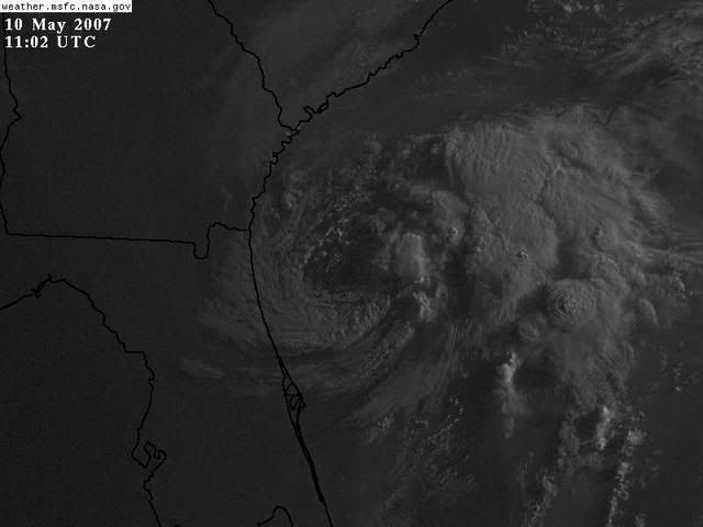
Stratusxpeye wrote:This thing is just going to sit there for days huh? And bring not one drop of drizzle rain let alone anything measurable to 90% of Florida if not 100%. I can not belive there calling this a storm still. In my opinion I would have to say it's down to a depression. They may find one spot of TS winds at flight level but I almost gaurente there's non on the surface, especially not over land. I know it's a bold statement but it's my statement on this system at this time. It's gonna be sitting there as a swirl though for a very long time.


Thunder44 wrote:They've been flying the in the NE Quad, and they haven't found any TS force winds at flight level. Thunderstorm activity is well over 100miles east and NE of the center and has diminished somewhat. This might be downgraded at 11am.
Users browsing this forum: No registered users and 94 guests