Smoke in GA/FL
Moderator: S2k Moderators
Forum rules

The posts in this forum are NOT official forecast and should not be used as such. They are just the opinion of the poster and may or may not be backed by sound meteorological data. They are NOT endorsed by any professional institution or STORM2K.
-
MiamiensisWx
Conditions have improved in portions of southeast Florida. The visibility has dramatically cleared at my location. I can detect only a faint smoky smell. With lower CAPE values and greater convective capping moving into the region, conditions should improve across most of the southern peninsula.
0 likes
-
Aquawind

- Category 5

- Posts: 6714
- Age: 62
- Joined: Mon Jun 16, 2003 10:41 pm
- Location: Salisbury, NC
- Contact:
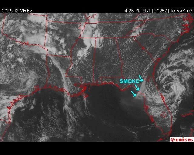
Big fire in Collier. Alligator Alley has been closed.
Nice pic of the Smoke..
http://modis.gsfc.nasa.gov/gallery/indi ... 2007-05-10
Nice pic of the Smoke..
http://modis.gsfc.nasa.gov/gallery/indi ... 2007-05-10
0 likes
-
O Town
- S2K Supporter

- Posts: 5205
- Age: 52
- Joined: Wed Sep 07, 2005 9:37 pm
- Location: Orlando, Florida 28°35'35"N 81°22'55"W
Aquawind wrote:Big fire in Collier. Alligator Alley has been closed.
Nice pic of the Smoke..
http://modis.gsfc.nasa.gov/gallery/indi ... 2007-05-10
Wow, fishing in the gulf off south FL would not be pleasant right now.
Seems like all the smoke from all the fires north of there is just accumulating right off the coast of Sarasota, and Lee counties. Great image link.
0 likes

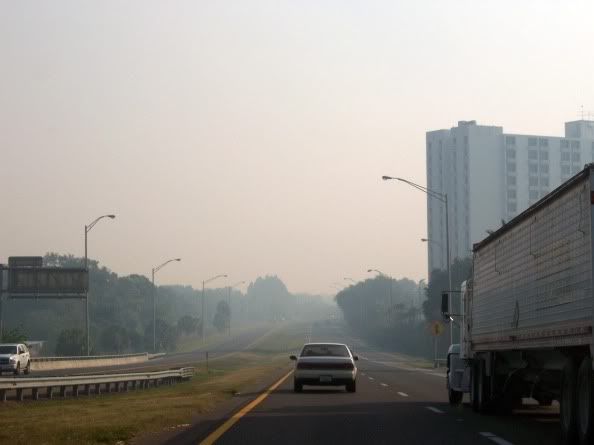
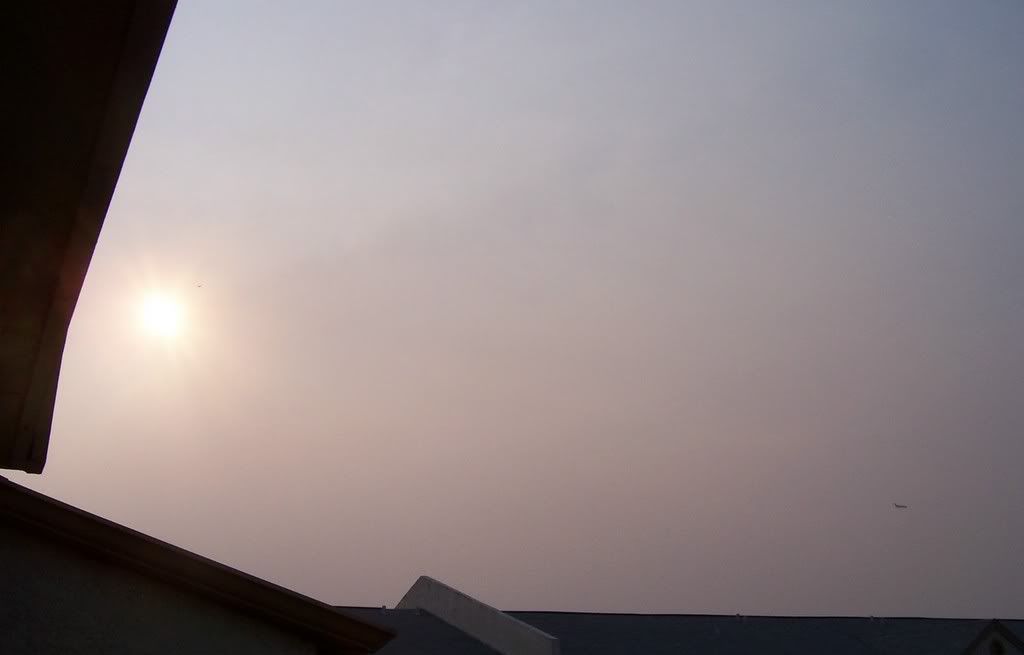
Starting to smell a little smokey in Tampa again. According to the NWS Tampa Bay - it will probably get worse later today and again tomorrow.
...SMOKY CONDITIONS RETURNING LATER TODAY AND CONTINUING INTO FRIDAY
NIGHT MAINLY INLAND FROM THE COAST...
THIS HAZARDOUS WEATHER OUTLOOK IS FOR THE TAMPA BAY METRO AREA AND
POINTS EAST.
.DAY ONE...TODAY AND TONIGHT.
...DENSE FOG/SMOKE IMPACT...
SMOKE FROM LARGE WILD FIRES IN NORTH FLORIDA AND EXTREME SOUTHERN
GEORGIA WILL ONCE AGAIN SPREAD SOUTH AND EAST LATER TODAY AND
ESPECIALLY TONIGHT AS LOW LEVEL WINDS BECOME NORTHERLY. VISIBILITY
MAY DROP BELOW 2 MILES IN A FEW LOCATIONS OVERNIGHT. LOCATIONS
MOST AT RISK INCLUDE THE NORTHERN AND EASTERN SUBURBS OF TAMPA BAY
EAST AND SOUTHEAST TO THE SOUTH CENTRAL FLORIDA
PENINSULA...MAINLY LATER TONIGHT.
http://www.srh.noaa.gov/showsigwx.php?w ... er+Outlook
0 likes
-
TampaSteve

- Tropical Storm

- Posts: 210
- Joined: Sat Sep 02, 2006 4:05 pm
- Location: Riverview, FL
dizzyfish wrote:Starting to smell a little smokey in Tampa again. According to the NWS Tampa Bay - it will probably get worse later today and again tomorrow.
...SMOKY CONDITIONS RETURNING LATER TODAY AND CONTINUING INTO FRIDAY
NIGHT MAINLY INLAND FROM THE COAST...
THIS HAZARDOUS WEATHER OUTLOOK IS FOR THE TAMPA BAY METRO AREA AND
POINTS EAST.
.DAY ONE...TODAY AND TONIGHT.
...DENSE FOG/SMOKE IMPACT...
SMOKE FROM LARGE WILD FIRES IN NORTH FLORIDA AND EXTREME SOUTHERN
GEORGIA WILL ONCE AGAIN SPREAD SOUTH AND EAST LATER TODAY AND
ESPECIALLY TONIGHT AS LOW LEVEL WINDS BECOME NORTHERLY. VISIBILITY
MAY DROP BELOW 2 MILES IN A FEW LOCATIONS OVERNIGHT. LOCATIONS
MOST AT RISK INCLUDE THE NORTHERN AND EASTERN SUBURBS OF TAMPA BAY
EAST AND SOUTHEAST TO THE SOUTH CENTRAL FLORIDA
PENINSULA...MAINLY LATER TONIGHT.
http://www.srh.noaa.gov/showsigwx.php?w ... er+Outlook
Yeah, I noticed it smelled a bit smoky this morning, and there was some haziness, but not nearly as bad as it was on Tuesday.
0 likes

-
JonathanBelles
- Professional-Met

- Posts: 11430
- Age: 35
- Joined: Sat Dec 24, 2005 9:00 pm
- Location: School: Florida State University (Tallahassee, FL) Home: St. Petersburg, Florida
- Contact:
Its getting worse: http://www.ssd.noaa.gov/goes/flt/t1/loop-vis.html
Once out in the GOM it looks like it spreads out. Its gonna get very smoky in a few hours here.
Once out in the GOM it looks like it spreads out. Its gonna get very smoky in a few hours here.
0 likes
-
TampaSteve
- Tropical Storm
- Posts: 210
- Joined: Sat Sep 02, 2006 4:05 pm
- Location: Riverview, FL
-
JonathanBelles
- Professional-Met
- Posts: 11430
- Age: 35
- Joined: Sat Dec 24, 2005 9:00 pm
- Location: School: Florida State University (Tallahassee, FL) Home: St. Petersburg, Florida
- Contact:
Special Weather Statement
SPECIAL WEATHER STATEMENT
NATIONAL WEATHER SERVICE TAMPA BAY RUSKIN FL
1001 PM EDT THU MAY 10 2007
FLZ039-042-043-048>052-055>057-060>062-065-111015-
LEVY-CITRUS-SUMTER-HERNANDO-PASCO-PINELLAS-HILLSBOROUGH-POLK-
MANATEE-HARDEE-HIGHLANDS-SARASOTA-DE SOTO-CHARLOTTE-LEE-
INCLUDING THE CITIES OF...CEDAR KEY...CHIEFLAND...CRYSTAL RIVER...
INVERNESS...BUSHNELL...THE VILLAGES...BROOKSVILLE...SPRING HILL...
NEW PORT RICHEY...ZEPHYRHILLS...CLEARWATER...ST. PETERSBURG...
BRANDON...TAMPA...LAKELAND...WINTER HAVEN...BRADENTON...
WAUCHULA...SEBRING...AVON PARK...SARASOTA...VENICE...ARCADIA...
PORT CHARLOTTE...PUNTA GORDA...CAPE CORAL...FORT MYERS
1001 PM EDT THU MAY 10 2007
...SMOKY CONDITIONS WILL AFFECT MUCH OF WEST CENTRAL AND SOUTHWEST
FLORIDA OVERNIGHT AND FRIDAY...
NORTHERLY WINDS AROUND 10 MPH WILL CONTINUE TO BRING SMOKE DOWN
ACROSS THE AREA FROM THE FIRES IN SOUTHEAST GEORGIA AND NORTH
CENTRAL FLORIDA. OTHER SMALLER FIRES ACROSS THE AREA WILL
CONTRIBUTE TO THE SMOKY CONDITIONS. FOR THE OVERNIGHT PERIOD...THE
MOST DENSE SMOKE WILL AFFECT LEVY...CITRUS...AND HERNANDO
COUNTIES...WHERE VISIBILITIES MAY OCCASIONALLY DROP TO AROUND 1/2
MILE. FARTHER SOUTH ACROSS TAMPA BAY AND SURROUNDING AREAS...THE
SMOKE WILL GRADUALLY INCREASE IN COVERAGE AND DENSITY THROUGH THE
NIGHT WITH AIR QUALITY WORSENING AND VISIBILITIES DECREASING.
THESE SMOKY CONDITIONS ARE EXPECTED TO CONTINUE THROUGH MOST OF
FRIDAY...WITH THE SMOKE GRADUALLY WORSENING SOUTH AROUND THE FORT
MYERS AREA DURING THE DAY FRIDAY.
PEOPLE ACROSS THE AREA WITH BREATHING PROBLEMS SHOULD REMAIN
INSIDE WITH THE WINDOWS CLOSED AND THE AIR CONDITIONING ON UNTIL
THE SMOKE CLEARS. MOTORISTS NEED TO ALSO USE CAUTION WHILE DRIVING
IN THE SMOKE AS VISIBILITIES WILL BE REDUCED.
$$
0 likes
-
Rainband
-
TampaSteve
- Tropical Storm
- Posts: 210
- Joined: Sat Sep 02, 2006 4:05 pm
- Location: Riverview, FL
The smoke is back! It's real bad this morning here in Tampa Bay. It's supposed to be with us through the weekend.
So far, over 300 SQUARE MILES have burned in those fires...that's almost 200,000 acres...no wonder we're getting so much smoke.
Looks like Andrea isn't going to do anything but fan the flames. Oh, well...
So far, over 300 SQUARE MILES have burned in those fires...that's almost 200,000 acres...no wonder we're getting so much smoke.
Looks like Andrea isn't going to do anything but fan the flames. Oh, well...
0 likes
-
JonathanBelles
- Professional-Met
- Posts: 11430
- Age: 35
- Joined: Sat Dec 24, 2005 9:00 pm
- Location: School: Florida State University (Tallahassee, FL) Home: St. Petersburg, Florida
- Contact:

You would think they would run some heavy duty filters on the schools AC?
I'm using a box fan with a walmart blue electrostatic filter here in my office.
The filter comes with a charcoal mesh that takes out most of the odor and the electrostatic blue fiberglass will remove most of the soot particles if you run the fan on LOW.
Should clear out in Pinellas over the next few hours but south Florida looks like it may be the next target.
0 likes


http://www.jacksonville.com/tu-online/s ... 8934.shtml
Less than a week after lightning started it, the Bugaboo Scrub Fire has eclipsed another huge fire.
Georgia fire information officials said today the Bugaboo fire has burned 179,445 acres, 97,445 in Ware County, Ga., and 82,500 in Baker County, Fla.
Residents in Ware and Charlton counties had referred to the 117,535 Sweat Farm/Big Turnaround Fire as "The Monster" but now it's not the biggest fire in the woods.
With northeast winds pushing it, the fire was moving toward the western edge of the Okefenokee Swamp where the Southern Area Incident Management Team was amassing crews to widen fire breaks to prevent the fire from jumping to privately owned uplands.
There are thinly populated areas in the fire's path along U.S. 177 in Clinch County and also the city of Fargo, where about 400 people live.
Officials also said the fire and smoke is being pushed toward the busy Interstate 75-Interstate 10 interchange north of Lake City.
Today's weather is expected to make fighting the fire difficult.
The wind is expected to come from the northeast at seven to 10 mph with gust of 20 mph and with a high of about 90 degrees.
Every entrance to the swamp remains closed.
You also have 18,000 acre fire in Bradford County.
A lot of fire up in North Florida/South Georgia. Its nasty nasty nasty.[/quote]
0 likes
-
TampaSteve
- Tropical Storm
- Posts: 210
- Joined: Sat Sep 02, 2006 4:05 pm
- Location: Riverview, FL
-
JonathanBelles
- Professional-Met
- Posts: 11430
- Age: 35
- Joined: Sat Dec 24, 2005 9:00 pm
- Location: School: Florida State University (Tallahassee, FL) Home: St. Petersburg, Florida
- Contact:
-
TampaSteve
- Tropical Storm
- Posts: 210
- Joined: Sat Sep 02, 2006 4:05 pm
- Location: Riverview, FL
Return to “USA & Caribbean Weather”
Who is online
Users browsing this forum: AnnularCane and 72 guests