Thanks, AFM & Mwatkins:
I think people sometimes miss just how complicated it is to get an upper/mid low to reach the surface. Sometime a few years ago, someone went through how a cut off cold low can transition to a surface, tropical low. That would be good to revisit sometime.
Setting that aside, though, a laypersons's way of asking this would be this...that same upper/mid low slid down the Fla Peninsula, and then WSW to the Yucatan, firing off a ton of convection (esp over Fla) as it did.
So, the skeptic would ask...why would we expect this same dynamic (cold air aloft with the low creating instability and "garden variety" t-storms) to work its way down to the surface here, off of the Yucatan, today, when it did not do so as the same set up exited Fla.
Answer--it likely won't, because this dynamic, in this set up just doesn't happen very often (it's complicated to get going and the conditions have to be just right!), and we saw exactly that a week ago with the same kind of thunderstorms caused by the same upper/mid low over Fla (I hope my memory is correct!).
WJS3
Still Watching Yucutan
Moderator: S2k Moderators
Forum rules

The posts in this forum are NOT official forecasts and should not be used as such. They are just the opinion of the poster and may or may not be backed by sound meteorological data. They are NOT endorsed by any professional institution or STORM2K. For official information, please refer to products from the National Hurricane Center and National Weather Service.
-
Air Force Met
- Military Met

- Posts: 4372
- Age: 56
- Joined: Tue Jul 08, 2003 9:30 am
- Location: Roan Mountain, TN
wjs3 wrote:Thanks, AFM & Mwatkins:
I think people sometimes miss just how complicated it is to get an upper/mid low to reach the surface. Sometime a few years ago, someone went through how a cut off cold low can transition to a surface, tropical low. That would be good to revisit sometime.
Setting that aside, though, a laypersons's way of asking this would be this...that same upper/mid low slid down the Fla Peninsula, and then WSW to the Yucatan, firing off a ton of convection (esp over Fla) as it did.
So, the skeptic would ask...why would we expect this same dynamic (cold air aloft with the low creating instability and "garden variety" t-storms) to work its way down to the surface here, off of the Yucatan, today, when it did not do so as the same set up exited Fla.
Answer--it likely won't, because this dynamic, in this set up just doesn't happen very often (it's complicated to get going and the conditions have to be just right!), and we saw exactly that a week ago with the same kind of thunderstorms caused by the same upper/mid low over Fla (I hope my memory is correct!).
WJS3
It is very difficult. Thermodynamically, the latent heat release of condensation helps spin up the mid level vorticity and lower the over-all sfc pressures. If the convection doesn't hang around for any period of time...then the mid level vorticity dissipated and the sfc pressures never fall. So...in order for this to happen...it takes days of continued convection. It may be spotty...but it can't be just diurnal.
0 likes

AFM, I just hope your posts don't go into waste and somebody will learn out of this discussion that should had been over a long time ago. How much more evidence can you give before somebody gets it that there will be no tropical development near 24N/92W out of the current & future forecasted atmospheric conditions? I don't get.
0 likes


-
tropicsgal05

- Tropical Depression

- Posts: 92
- Joined: Sun Jun 05, 2005 7:25 am
- Location: FT. Walton Beach. Florida

Stratosphere747 wrote:
While somewhat irritating, most all the "season cancel" posts are made in jest. Be another few weeks before people become emotionally scarred...
Back on subject - Still see nothing in the Yucatan area to become remotely concerned.
Yeah, I know that.
0 likes
-
Berwick Bay
Air Force Met wrote:Berwick Bay wrote: Looking for a "bursting effect" (images of red, not yellow) from infrared pics over the Yucutan Coast today. This would help bring in a lower level circulation there.
You probably will get some deep convection over the Yucatan today. The upper low is there: It's cold aloft and the Yucatan is on its divergent side heating up in the sun. All of those ingredients destablize the atmopshere. It happens all the time over land in the tropics during the summer. When I was stationed in Belize...I would always forecast TSTMS when I saw this setup.
That being said...that sort of setup doesn't bring in LLC's. It may spin up areas of mid level vorticity...but it won't create a LLC since there is no low level cyclonic turning already in existence...and the convection will die after the sun goes down and the atmosphere stablizes.
Thank you Air Force for your well reasoned and considerate reply. BTW I told my wife that some at Storm 2k said I was overly sensitive to critisism, and she AGREED. So maybe you guys have something of a point. I've posted on web sites for a few years now, but I'm still not all that comfortable with the "bluntness", shall we say, of this medium. Anyway, I have seen areas in the tropics in the past where the convection from intense thunderstorms did contribute to lower of pressures. But if upper level conditions are not right, well I guess nothing is going to happen. Tomorrow begins the June 13th --June 16th time frame in the Western Gulf. Looks like pie all over my face for this one.
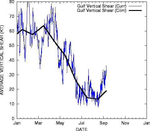
And starting tomorrow...at 24/92...well all over the Gulf for that matter...the upper winds are as unfavorable for this time of year for development as they possibly canbe. There is 35 kts of shear over that area tmorrow. IT lessens for a day on Thursday...but is back with a vengence by Friday and Saturday with 50kts over the northern Gulf. The upper winds will be about as unfavorable for development as we can get.
0 likes

-
SouthFloridawx

- S2K Supporter

- Posts: 8346
- Age: 47
- Joined: Tue Jul 26, 2005 1:16 am
- Location: Sarasota, FL
- Contact:
I would like to know what all this talk about wind shear being so high across the Atlantic, GOM and Caribbean? I'm looking at the wind shear analysis and please let me know if I can read this thing or not... The highest I see in the Atlantic Basin is off of the east coast @ a little over 60kts. Pretty much the entire GOM and Caribbean have between 0-30 kts of shear. I remember Barry formed and found a nice little pocket of lowered wind shear for a short amount of time, and got the required characterists (as it stands now) to attain tropical storm status here in the Atlantic. I would say that it is not so far fetched to think that another little area of low pressure could form, as most people said it was impossible and also given that, as soon as Barry met up with the higher wind shear values those cloud tops were ripped off to the NE. So if some are suggested that simply because, we got a 500mb moving down close to the south, we won't see a pocket of low shear, to the sw of it for a short period of time to allow something to pop up and quickly move off to the NE? I mean wind shear values are currently not entirely the worst either.

I think we'll need to watch that TW that used to be 93L as it approaches the Caribbean and the northern extent is just to the north of th islands. Best chance a wave has had all season so far.
EDIT: Added word, "Not" to so far fetched.
I think we'll need to watch that TW that used to be 93L as it approaches the Caribbean and the northern extent is just to the north of th islands. Best chance a wave has had all season so far.
EDIT: Added word, "Not" to so far fetched.
0 likes
-
Starburst

- S2K Supporter
- Posts: 484
- Joined: Sun Aug 28, 2005 11:03 pm
- Location: Beeville, TX
- Contact:
I was going to ask AFM the same thing about the high shear. Is it because of the frontal boundary entering the area this weekend that is going to produce the high shear? Shear seems to go from modest to extreme within a short time frame and that was my thought on it and just want to see if that is a correct assessment.
Last edited by Starburst on Tue Jun 12, 2007 2:07 pm, edited 1 time in total.
0 likes
-
jasons2k

- Storm2k Executive

- Posts: 8252
- Age: 52
- Joined: Wed Jul 06, 2005 12:32 pm
- Location: The Woodlands, TX
Here are some interesting links to peruse:
http://www.ssd.noaa.gov/PS/TROP/DATA/gparm/gmxshr.gif
http://www.ssd.noaa.gov/PS/TROP/DATA/gparm/xyrfpr.gif
But according to the GFS, conditions in the S/SW GOM will only be favoralbe for another ~60 hours:
http://www.meteo.psu.edu/~gadomski/TROPDEV/devloop.html
http://www.ssd.noaa.gov/PS/TROP/DATA/gparm/gmxshr.gif
http://www.ssd.noaa.gov/PS/TROP/DATA/gparm/xyrfpr.gif
But according to the GFS, conditions in the S/SW GOM will only be favoralbe for another ~60 hours:
http://www.meteo.psu.edu/~gadomski/TROPDEV/devloop.html
0 likes
-
tolakram
- Admin
- Posts: 20168
- Age: 62
- Joined: Sun Aug 27, 2006 8:23 pm
- Location: Florence, KY (name is Mark)
Berwick Bay,
what led you to predict formation during this time period and what hasn't happened that needed to happen for development to occur? Sorry if I missed that in all the threads, but analysis of what went wrong would help me, at least, understand where you're coming from. I'm here to learn about the tropics as much as watch what's happening.
what led you to predict formation during this time period and what hasn't happened that needed to happen for development to occur? Sorry if I missed that in all the threads, but analysis of what went wrong would help me, at least, understand where you're coming from.
0 likes
-
Berwick Bay
tolakram wrote:Berwick Bay,
what led you to predict formation during this time period and what hasn't happened that needed to happen for development to occur? Sorry if I missed that in all the threads, but analysis of what went wrong would help me, at least, understand where you're coming from.
Now Cincy, thats very kind of you to ask me about meterological matters. The last couple of days should have taught you to be wary about asking me anything of a meterological nature. But since you asked, here goes.
a. Climatology--I never mentioned this before. If you are going to get development in Mid June, climatologically, the West Central Gulf is not a bad place to look.
b. I look at large scale water vapor loops which cover most of North America and the Western Atlantic Basin. Here I'm looking for long range upper level trends. I'll try to pick a point where stable air aloft is most likely to occur.
c. Overall propensity for develpment in the Basin. With Andrea, and then Barry, I thought it might make for a good long shot bet, for development in the time frame about two weeks after Barry.
D. Sixth Sense- A line from "Crystal Ball" after looking at the loops goes "Remember what you have seen, then look up and forget. Swim or better yet, sleep." Its a way to digest the information and then activate prophetic abilities.
What went wrong?
a. Everything
b. I forced it. After my last success with Barry, I was hungry to prove that it was no fluke. As a matter of fact, I know that I didn't follow my own advice in "Crystal Ball".
c. Upper levels--I was hoping for a strong High in the West Gulf. But the troughiness in the East Gulf just stuck around longer than I thought. Finally an Upper Low developed at the bottom of the trough. At first I thought it would be my salvation, "to reset the table" on an otherwise bleak picture. But the ULL ended up being a semi-permanent feature (many days in the area) and brought about a severe line of demarcation in the Central Gulf between itself and the Upper Level High. A moderate area of transition would have been good. But the Upper High over Mexico is very powerful, and the Gulf has shown shear coming from different directions, none of it good for development, as a result of these two conflicting air masses.
0 likes

Berwick Bay, stop beating yourself up. I don't know of one single professional meteorologist that has been right 100% of the time. Unlike alot of amateurs you are at least taking what you do know and building upon it. The only people who never fail are the ones who don't do anything. You gave a great analysis of why this system did not materialize the way you had predicted which means that you've learned from your experience. Please don't stop learning and don't give up predicting future storms.
0 likes
-
tolakram
- Admin
- Posts: 20168
- Age: 62
- Joined: Sun Aug 27, 2006 8:23 pm
- Location: Florence, KY (name is Mark)
Thanks BB.
Well that actually doesn't sound that far fetched. Sometimes the back of the brain can recognize patterns before the front of the brain can explain them. In my opinion, of course. I certainly appreciate the honesty of your reply.
Sixth Sense- A line from "Crystal Ball" after looking at the loops
Well that actually doesn't sound that far fetched. Sometimes the back of the brain can recognize patterns before the front of the brain can explain them. In my opinion, of course. I certainly appreciate the honesty of your reply.
0 likes
-
Air Force Met
- Military Met
- Posts: 4372
- Age: 56
- Joined: Tue Jul 08, 2003 9:30 am
- Location: Roan Mountain, TN
SouthFloridawx wrote:I would like to know what all this talk about wind shear being so high across the Atlantic, GOM and Caribbean? I'm looking at the wind shear analysis and please let me know if I can read this thing or not... The highest I see in the Atlantic Basin is off of the east coast @ a little over 60kts. Pretty much the entire GOM and Caribbean have between 0-30 kts of shear. I remember Barry formed and found a nice little pocket of lowered wind shear for a short amount of time, and got the required characterists (as it stands now) to attain tropical storm status here in the Atlantic. I would say that it is not so far fetched to think that another little area of low pressure could form, as most people said it was impossible and also given that, as soon as Barry met up with the higher wind shear values those cloud tops were ripped off to the NE. So if some are suggested that simply because, we got a 500mb moving down close to the south, we won't see a pocket of low shear, to the sw of it for a short period of time to allow something to pop up and quickly move off to the NE? I mean wind shear values are currently not entirely the worst either.
I think we'll need to watch that TW that used to be 93L as it approaches the Caribbean and the northern extent is just to the north of th islands. Best chance a wave has had all season so far.
EDIT: Added word, "Not" to so far fetched.
OK...I'm back and let me try to address your question. I will start with this piece of advice: Not all shear is alike. Remember that. Just because Barry did something doesn't mean another system can accomplish the same feat. Second...I will say I rarely look at shear charts. Matter of fact...the only time I ever do is when people on S2K post them. I don't find that I need them to forecast. I need to look at the upper level charts and the low level steering. If you want to learn how to properly read a shear map...I can teach you: Stop looking at them
Here's how its done. Barry, for instance, was in 20-30 kts of SW flow aloft. However, the low level steering had Barry headed north at 10 kts. That knocked Barry's shear down to 10 kts of relative shear...plenty low enough to allow for development....especially given the fact it was on the eastern side of a diffluent upper level trof. That added to the ventilation...making the lowering of the pressure somewhat baroclinic in nature and not purely by tropical mechanisms. It wasn't until the 2nd that the 20 kts of sfc movement to the NNE couldn't deal with the 40-50 kts of shear. That produced 20-30 kts of relative shear and it ripped the guts out of it and frankly turned it into a baroclinic ET system.
Now...about the current setup. Whereas Barry was located on the eastern side of the trof and on the western edge of a sfc high and could move with the upper flow...anything that might try and develop here is going to be on the western side of the trof and will be going against the upper flow. So...instead of subtracting from the upper shear with the low level motion...you are adding to it. 25 kts of upper wind becomes 35-40 kts when the system grates against it. Plus...Barry was in the "wet" side of the upper trof...moist SW flow aloft in the tropics and a pre-existing disturbance at the surface combined with the difluence to get Barry going.
Here: Dry flow aloft around the back-side of an upper low. NO...big bold letters....NO pre-existing disturbance at the sfc. Even if there was...it would be moving west AGAINST 20-30 kts of shear at 10-15 kts...producing 30-45 kts of shear (in a bone-dry upper level environment)...unlike Barry which moved with the flow with upper level winds about the same speed.
And...even if something DID form...there is going to be a wall of shear along the northern GOM. 200 mb winds north of 28N are 45-50 kts because of an upper low over the NE and an upper low dipping down into Texas. Things start to improve by late weekend in the southern GOM and SE GOM.
You must remember...Barry was a pre-existing feature. Barry just didn't form in an area of low shear aloft. Barry was around for a while...it was tracked for several days was a sfc trof/wave. It was producing showers for a while before it met up with enough upper level divergence ahead of the trof to spin it up. So...even if there was some pocket of low shear...there is no pre-existing disturbance at the sfc in the area. Which, BTW, is one of the necessary ingredients for tropical development. If you don't have that...you have to make it...and it takes DAYS of convection by an upper low. That won't happen.
This is not the same setup. There is no sfc feature...there is no divergence...the two situations are totally different.
0 likes
Who is online
Users browsing this forum: ljmac75 and 29 guests