
http://www.pdfamily.com/weather/buoy/FLbuoy.php
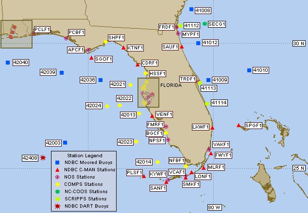
when you click on the link it has current data and rotates through each set for each of the buoys listed in the pic above
Moderator: S2k Moderators

NDG wrote:Recurve wrote:Pressure trending down off Miami
One to two MB drop compared to 24 hrs ago, I would call that barely trending down in the short term, and at least 4-5 MB drops in 24 hrs is what I would look for any signs of development.
.DISCUSSION...IN THE MID AND UPPER LEVELS(700-200 MB)...LATEST
SATELLITE IMAGERY AND STREAMLINE ANALYSIS AS OF 900 AM DEPICT THE
AXIS OF A SHORTWAVE TROUGH IN THE EASTERN GULF OF MEXICO...NOW
APPROACHING THE FLORIDA PENINSULA AND THE KEYS. TO THE SOUTH...THE
CENTER OF A DEEP AND WARM CORE ANTICYCLONE HAS RETREATED SOUTHWARD
OVERNIGHT...AND IS NOW POSITIONED SOUTHWEST OF THE CAYMAN ISLANDS.
THE FLORIDA KEYS ARE NOW ENTERING MID AND UPPER CYCLONIC FLOW IN
ASSOCIATION WITH THE APPROACHING SHORTWAVE...WITH SLIGHTLY INCREASED
MID AND UPPER OMEGA COMBINED WITH SLIGHTLY HIGHER MOISTURE PUMPING
IN FROM THE WEST BETWEEN THE 500-300 MB LAYER.
IN THE LOWER AND MIDDLE LEVELS(SURFACE TO 700 MB)...A LOW LEVEL
RIDGE EXTENDS FROM THE CENTRAL ATLANTIC SOUTHWEST TO THE SOUTHEAST
BAHAMAS. A TROUGH OF LOW PRESSURE IS JUST NORTH OF THE BAHAMAS...AND
EXTENDS SOUTHWEST TO THE KEYS. THE FLORIDA KEYS LIE NORTH OF A WEAK
RIDGE WHICH CAN BE ANALYZED ALONG THE SPINE OF CUBA...WITH ANOTHER
WEAK HIGH CENTER OVER THE CENTRAL GULF OF MEXICO.
.CURRENTLY...AS OF 900 AM...TEMPERATURES ARE IN THE MIDDLE 80S WITH
DEWPOINTS IN THE MIDDLE 70S. A BROKEN CLOUD LINE IS ACTIVE FROM BIG
PINE TO KEY WEST...AND SEVERAL WATERSPOUTS HAVE BEEN REPORTED JUST
NORTHEAST OF THE AIRPORT AND NORTH OF BAY POINT AND THE SUGARLOAFS.
SKIES ARE PARTLY TO MOSTLY CLOUDY OVER THE LOWER KEYS...AND PARTLY
CLOUDY IN THE MIDDLE AND UPPER KEYS. KEY WEST RADAR DETECTS
SCATTERED SHOWERS ALONG PORTIONS OF THE KEYS WITHIN THE CLOUDLINE
FROM BAHIA HONDA TO BOCA CHICA...WITH THE POSSIBILITY OF A FEW
LIGHTNING STRIKES. THE VWP...VAD WIND PROFILER AND THE 12Z SOUNDING
AT KEY WEST DUE INDICATE THE BEST SOUTHWEST PROFILE FOR CUMULUS
CLOUD LINE FORMATION IN THE PAST 3 DAYS THAT I HAVE BEEN ON SHIFT.
PWAT(PRECIPITABLE WATER) IS AT 1.93 OR CLOSE TO TWO INCHES.
THERMODYNAMICALLY...THE 12Z SOUNDING IS CONDITIONALLY UNSTABLE TO
UNSTABLE. WINDS OVER THE ISLANDS AND ALONG THE FLORIDA REEF ARE
SOUTHWEST NEAR 10 KNOTS...EXCEPT VARIABLE AND GUSTY IN OR NEAR
CUMULUS LINE GENERATED OUTFLOWS.
.FORECAST...IN THE MID AND UPPER LEVELS(700-200 MB)...(TODAY)...THE
SHORTWAVE AXIS TO OUR WEST WILL MOVE ACROSS THE PENINSULA
TODAY...BUT 06Z MODEL RUNS SHOW A VERY FAINT AXIS OF THIS WAVE
MOVING ACROSS THE PENINSULA. THIS WILL ACT TO AID AND ABET CUMULUS
CLOUD-LINE FORMATIONS AND INCREASE RAIN AND THUNDER CHANCES GIVEN
THE 12Z THERMODYNAMIC PROFILE IN PLACE.
...IN THE LOW AND MIDDLE LEVELS...(SURFACE TO 700 MB)...WEAK RIDGING
WILL REMAIN NEAR THE ENTIRE NORTH COAST OF CUBA THROUGHOUT THE
COURSE OF THE DAY. GIVEN THE LATEST AVAILABLE SOUTHWEST FLOW FROM
THE SURFACE TO ABOUT 600 MB...WILL CONTINUE THE SEE A MODERATE TO
HIGH RISK OF WATERSPOUTS THROUGHOUT THE DAY...WITH GREATER THAN
NORMAL SHOWER COVERAGE THROUGHOUT THE KEYS AND ADJOINING WATERS.
THEREFORE...A GOOD CHANCE OF RAIN WITH ISOLATED THUNDERSTORMS SEEMS
REASONABLE FOR TODAY. NO CHANGES EXPECTED TO THE PUBLIC MORNING
PACKAGE. ONLY NOTE IS THAT SURFACE WINDS APPEAR TO BE MORE
SOUTHWESTERLY THAN WESTERLY. THIS MAY BE INDICATED IN THE MARINE
FORECAST UPDATE.
SPECIAL WEATHER STATEMENT
NATIONAL WEATHER SERVICE JACKSONVILLE FL
118 PM EDT SUN JUL 1 2007
FLZ032-011800-
CLAY-
118 PM EDT SUN JUL 1 2007
...A SIGNIFICANT WEATHER ALERT HAS BEEN ISSUED FOR NORTHERN CLAY
COUNTY FOR STRONG WINDS...SMALL HAIL AND EXCESSIVE LIGHTNING VALID
UNTIL 200 PM EDT...
AT 118 PM EDT NATIONAL WEATHER SERVICE DOPPLER RADAR INDICATED A
STRONG THUNDERSTORM CENTERED 4 MILES WEST OF BELLAIR...OR 5 MILES
NORTHWEST OF LAKESIDE...MOVING SOUTHEAST AT 10 MPH. THIS
STRONG THUNDERSTORM WILL ALSO AFFECT AREAS AROUND LAKESIDE...ORANGE
PARK AND DOCTORS INLET THROUGH 200 PM EDT. HAIL UP TO ONE HALF INCH
IN DIAMETER...EXCESSIVE CLOUD-TO-GROUND LIGHTNING AND GUSTY WINDS OF
45 TO 55 MPH CAN BE EXPECTED ALONG WITH POSSIBLE MINOR DAMAGE. HEAVY
RAINFALL WILL PRODUCE PONDING OF WATER ON ROADWAYS AND MINOR
FLOODING OF LOW-LYING AREAS.


Users browsing this forum: No registered users and 173 guests


