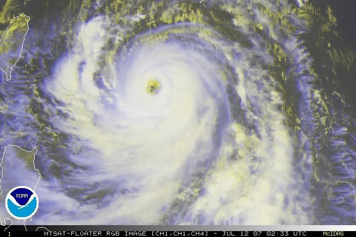
The JMA intensity estimate is probably correct (90KT 10 minute/cat 3 1 minute). The eyewall just closed off.
Also, the outer bands are starting to die. Now start to look for an EWRC
Typhoon Man-yi (04W)
Moderator: S2k Moderators
-
Category 5

- Category 5

- Posts: 10074
- Age: 35
- Joined: Sun Feb 11, 2007 10:00 pm
- Location: New Brunswick, NJ
- Contact:
-
Typhoon Hunter
- WesternPacificWeather.com

- Posts: 1222
- Joined: Wed Oct 11, 2006 11:37 am
- Location: Tokyo
- Contact:
Just made an attempt to get to Osaka (to catch connecting flight to Naha.) Unfortunately the forecast all came round overnight (Shanghai) time for a decent hit on Naha so when I woke up it was too late! Couldn't get flight out of Shanghai which would get me there in time.
Anyway JMA have Many-yi at 90kts and it's looking like Naha will get pounded by the strongest winds:
TY 0704 (MAN-YI)
Issued at 03:00 UTC, 12 July 2007RSMC TROPICAL CYCLONE ADVISORY
NAME TY 0704 MAN-YI (0704)
ANALYSIS
PSTN 120300UTC 21.6N 128.8E GOOD
MOVE NNW 14KT
PRES 935HPA
MXWD 090KT
GUST 130KT
50KT 120NM NORTHEAST 100NM SOUTHWEST
30KT 350NM EAST 280NM WEST
FORECAST
24HF 130300UTC 26.1N 127.1E 90NM 70%
MOVE N 11KT
PRES 925HPA
MXWD 095KT
GUST 135KT
45HF 140000UTC 29.3N 129.4E 160NM 70%
MOVE NE 11KT
PRES 930HPA
MXWD 090KT
GUST 130KT
69HF 150000UTC 32.0N 136.4E 270NM 70%
MOVE ENE 16KT
PRES 940HPA
MXWD 085KT
GUST 120KT
0 likes
-
Aslkahuna

- Professional-Met

- Posts: 4550
- Joined: Thu Feb 06, 2003 5:00 pm
- Location: Tucson, AZ
- Contact:
Re: Typhoon Man-yi (04W)
Kadena at 04Z reported easterly winds gusting to 37kt with a peak the past hour of 39 kt. The pressure was down to 996.9 mb. The forecast calls for winds to be Due North at 85G125kt by 0100Z tomorrow. It's early afternoon there now and the planes should be almost all out of there with their support crews and the Base will probably lock down this evening. Pregnant women in their third Trimester are probably arriving at the hospital now. Essential personnel will be reporting in around midnight for a long night and day. The time for the strongest winds (0100Z) is 10 AM JST so although the buildup of the storm will occur at night, the peak will occur in daylight as long as the storm holds the present course and speed.
Steve
Steve
0 likes

Re: Typhoon Man-yi (04W)=JMA Latest Advisory=80kts,950 mbs
CrazyC83 wrote:Eyewall wrote:can you post the page where you got that pic plz
btw the intensity estmations from CIMSS are up to 140kts and 899mb
That does seem a bit high, I don't think it is that strong yet...I'd say in reality (if there were recon aircraft to check out there) it would be about 130 kt and 926 mb.
That's the exact same intensity I was thinking.
0 likes
-
Typhoon Hunter
- WesternPacificWeather.com
- Posts: 1222
- Joined: Wed Oct 11, 2006 11:37 am
- Location: Tokyo
- Contact:
Up to 95kts now in 06z JMA update:
TY 0704 (MAN-YI)
Issued at 06:00 UTC, 12 July 2007RSMC TROPICAL CYCLONE ADVISORY
NAME TY 0704 MAN-YI (0704)
ANALYSIS
PSTN 120600UTC 22.2N 128.6E GOOD
MOVE NNW 13KT
PRES 930HPA
MXWD 095KT
GUST 135KT
50KT 140NM NORTHEAST 120NM SOUTHWEST
30KT 350NM EAST 280NM WEST
FORECAST
24HF 130600UTC 27.0N 127.5E 100NM 70%
MOVE N 15KT
PRES 925HPA
MXWD 095KT
GUST 135KT
48HF 140600UTC 31.2N 132.4E 160NM 70%
MOVE NE 15KT
PRES 935HPA
MXWD 085KT
GUST 120KT
72HF 150600UTC 34.8N 140.8E 270NM 70%
MOVE ENE 20KT
PRES 945HPA
MXWD 080KT
GUST 115KT
0 likes


Latest obs in from Kadena AFB:
RODN 121021Z AUTO 07024G39KT 9999 FEW001 BKN021 28/26 A2930 RMK AO2 PK WND 06039/1012 RAE1012DZB1012E1021 CIG 012V031 PRESFR SLP919
Latest from Naha International:
ROAH 121040Z 07017G27KT 030V100 8000 FEW008 SCT015 BKN090 29/25 Q0990 RMK 2ST008 3CU015 5AC090 A2924
Latest from Kumejima Airport, about 60 miles west of Naha:
ROKJ 121000Z 05020G32KT 9999 FEW018 SCT030 30/26 Q0992
And from Futenma Marine Corps Air Facility:
ROTM 121020Z 08023G35KT 6000 -SHRA BR BKN005 BKN030 BKN060 27/26 A2929 RMK SLP990 TCCOR1C SP29.000
0 likes

-
cycloneye

- Admin

- Posts: 148835
- Age: 69
- Joined: Thu Oct 10, 2002 10:54 am
- Location: San Juan, Puerto Rico
Re: Typhoon Man-yi (04W)
(MAN-YI)
Issued at 12:00 UTC, 12 July 2007RSMC TROPICAL CYCLONE ADVISORY
NAME TY 0704 MAN-YI (0704)
ANALYSIS
PSTN 121200UTC 23.5N 128.0E GOOD
MOVE NNW 14KT
PRES 930HPA
MXWD 095KT
GUST 135KT
50KT 140NM NORTHEAST 120NM SOUTHWEST
30KT 375NM EAST 290NM WEST
FORECAST
24HF 131200UTC 27.7N 127.6E 100NM 70%
MOVE NNE 12KT
PRES 930HPA
MXWD 095KT
GUST 135KT
48HF 141200UTC 32.1N 132.5E 160NM 70%
MOVE NE 15KT
PRES 945HPA
MXWD 080KT
GUST 115KT
72HF 151200UTC 35.2N 141.6E 270NM 70%
MOVE ENE 20KT
PRES 965HPA
MXWD 070KT
GUST 100KT
The latest JMA Advisory mantains it at 95kts.I think it has peaked in intensity and from now on it will start to go down.
0 likes
-
WindRunner

- Category 5
- Posts: 5806
- Age: 35
- Joined: Fri Jul 29, 2005 8:07 pm
- Location: Warrenton, VA, but Albany, NY for school
- Contact:
We now have recorded TS-force sustained winds at Kadena AB:
RODN 121306Z AUTO 07034G45KT 9999 -DZ SCT023 SCT030 BKN039 BKN065 28/25 A2922 RMK AO2 PK WND 07045/1301 RAE1256DZB1306 FEW023 V SCT SCT039 V BKN SLP893
Also getting close at Futenma:
ROTM 121258Z 08033G41KT 9999 BKN025 BKN035 OVC050 28/24 A2922 RMK PK WND 08041/50 SLP987 TCCOR1C T02780239 SP28.920
RODN 121306Z AUTO 07034G45KT 9999 -DZ SCT023 SCT030 BKN039 BKN065 28/25 A2922 RMK AO2 PK WND 07045/1301 RAE1256DZB1306 FEW023 V SCT SCT039 V BKN SLP893
Also getting close at Futenma:
ROTM 121258Z 08033G41KT 9999 BKN025 BKN035 OVC050 28/24 A2922 RMK PK WND 08041/50 SLP987 TCCOR1C T02780239 SP28.920
0 likes
If anyone is interested, here's the latest Japanese advisory, which also gives location, and a one-hour forecast (which the English adv does not carry):
台風第4号 (マンニィ)
Typhoon #4 (MAN-YI)
平成19年07月12日21時50分 発表
21:50 JST July 12, 2007 bulletin
<12日21時の実況>
Analysis at 2100 JST (12Z) July 12
大きさ 大型
Size: Large
強さ 非常に強い
Strength: Very strong (*Japanese local scale, as in Japan all >34 kt storms are locally "typhoons")
存在地域 那覇市の南 約300km
Current location: 300 km south of Naha City
中心位置 北緯 23度30分(23.5度)
東経 128度00分(128.0度)
Centre position 23.5N 128.0E
進行方向、速さ 北北西 25km/h(14kt)
Movement and speed North-northwest 14 kt
中心気圧 930hPa
Minimum central pressure 930 hPa
中心付近の最大風速 50m/s(95kt)
Maximum winds 95 kt
最大瞬間風速 70m/s(135kt)
Maximum gusts 135 kt
25m/s以上の暴風域 北東側 260km(140NM)
南西側 220km(120NM)
Radius of 25 m/s (50 kt) winds 140 NM NE, 120NM SW
15m/s以上の強風域 東側 700km(375NM)
西側 540km(290NM)
Radius of 15 m/s (30 kt) winds 375 NM E, 290 NM W
One-hour forecast:
<12日22時の推定>
大きさ 大型
強さ 非常に強い
存在地域 那覇市の南 約280km
中心位置 北緯 23度40分(23.7度)
東経 127度55分(127.9度)
進行方向、速さ 北北西 25km/h(14kt)
中心気圧 930hPa
中心付近の最大風速 50m/s(95kt)
最大瞬間風速 70m/s(135kt)
25m/s以上の暴風域 北東側 260km(140NM)
南西側 220km(120NM)
15m/s以上の強風域 東側 700km(375NM)
西側 540km(290NM)
0 likes

-
windstorm99

- S2K Supporter

- Posts: 1578
- Age: 48
- Joined: Sat May 26, 2007 8:10 am
- Location: Miami, Florida
- Contact:


Who is online
Users browsing this forum: No registered users and 49 guests