Severe T-Storm Watch Florida
Moderator: S2k Moderators
Forum rules

The posts in this forum are NOT official forecast and should not be used as such. They are just the opinion of the poster and may or may not be backed by sound meteorological data. They are NOT endorsed by any professional institution or STORM2K.
-
Cookiely

- S2K Supporter

- Posts: 3211
- Age: 75
- Joined: Fri Aug 13, 2004 7:31 am
- Location: Tampa, Florida
Re: Severe T-Storm Watch Florida
As my granny used to say, that was a frog strangling gully washer.
0 likes


Re: Severe T-Storm Watch Florida
Looks like the severe threat is over for Central Florida.
Here are a couple of hilights from Tampa Bay
Here are a couple of hilights from Tampa Bay
Code: Select all
PRELIMINARY LOCAL STORM REPORT
NATIONAL WEATHER SERVICE TAMPA BAY AREA - RUSKIN FL
619 PM EDT SAT JUL 21 2007

..TIME...   ...EVENT...      ...CITY LOCATION...     ...LAT.LON...
..DATE...   ....MAG....      ..COUNTY LOCATION..ST.. ...SOURCE....
            ..REMARKS..

0146 PM     FUNNEL CLOUD     SAINT PETERSBURG        27.76N 82.67W
07/21/2007                   PINELLAS           FL   PUBLIC

0150 PM     HAIL             1 NE SAINT PETERSBURG   27.77N 82.66W
07/21/2007  E0.75 INCH       PINELLAS           FL   PUBLIC

            PENNY SIZE HAIL NEAR 83RD AVENUE AND 77TH AVENUE.

0300 PM     TSTM WND DMG     PLANT CITY              28.01N 82.13W
07/21/2007                   HILLSBOROUGH       FL   BROADCAST MEDIA

            CHIMNEY AND POOL SCREEN DAMAGE AND A FEW TREES DOWN AT
            RESIDENCE IN 3323 SILVERPOND DRIVE AT WALDEN LAKES.

0323 PM     TSTM WND GST     ESE LAKELAND HIGHLANDS  27.96N 81.95W
07/21/2007  M56.00 MPH       POLK               FL   TRAINED SPOTTER

            MEATL SHED BLOWN INTO POWER LINE CAUSING A FIRE NEAR
            HIGHWAY 60 AND CORRNET ROAD.


0434 PM     TSTM WND GST     MACDILL AIR FORCE BASE  27.85N 82.50W
07/21/2007  M40.00 MPH       HILLSBOROUGH       FL   OTHER FEDERAL
0 likes
-
tropicana

- Category 5

- Posts: 8056
- Joined: Sat Sep 27, 2003 6:48 pm
- Location: Niagara Falls, Ontario, Canada
- Contact:
Re: Severe T-Storm Watch Florida
Also, a tornado was reported about 2 miles west of Tamiami International Airport in the suburbs west of Miami at about 3:20pm over an unpopulated area..this was reported by Law Enforcement officers.
Selected rainfall amounts for today:-
Miami International Airport 1.01 inches
West Palm Beach FL 2.01inches (record)
Sarasota FL 2.80 inches ( record)
Melbourne FL 3.04 inches ( record)
-justin-
Selected rainfall amounts for today:-
Miami International Airport 1.01 inches
West Palm Beach FL 2.01inches (record)
Sarasota FL 2.80 inches ( record)
Melbourne FL 3.04 inches ( record)
-justin-
Last edited by tropicana on Sat Jul 21, 2007 8:02 pm, edited 1 time in total.
0 likes
-
Category 5

- Category 5
- Posts: 10074
- Age: 36
- Joined: Sun Feb 11, 2007 10:00 pm
- Location: New Brunswick, NJ
- Contact:
Re: Severe T-Storm Watch Florida
Nasty Cell Coming Across The Santa Fe River,
As I was typing this lightning just hit basically right across the river. Shook the house.
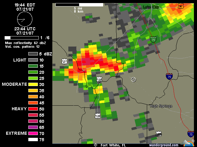
As I was typing this lightning just hit basically right across the river. Shook the house.
Last edited by Category 5 on Sat Jul 21, 2007 8:24 pm, edited 1 time in total.
0 likes
-
Category 5
- Category 5
- Posts: 10074
- Age: 36
- Joined: Sun Feb 11, 2007 10:00 pm
- Location: New Brunswick, NJ
- Contact:
Re: Severe T-Storm Watch Florida
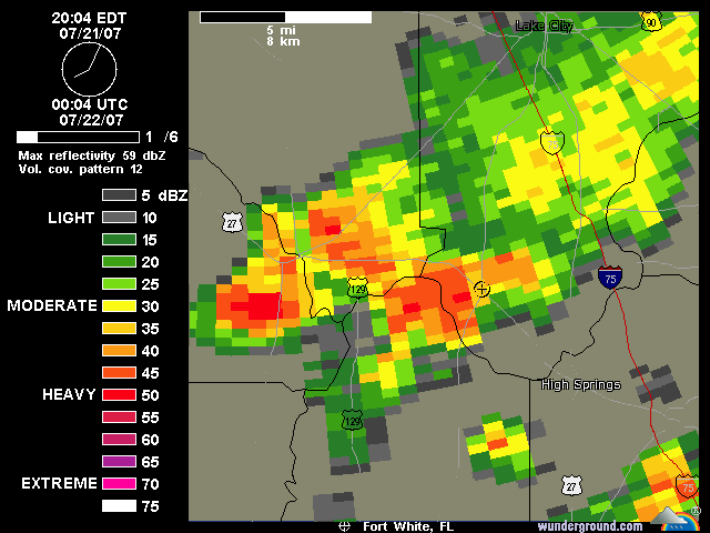
Blinding rain, lightning everywhere. ONe just hit close enough to shake everything.
0 likes
-
Category 5
- Category 5
- Posts: 10074
- Age: 36
- Joined: Sun Feb 11, 2007 10:00 pm
- Location: New Brunswick, NJ
- Contact:
-
JonathanBelles
- Professional-Met

- Posts: 11430
- Age: 35
- Joined: Sat Dec 24, 2005 9:00 pm
- Location: School: Florida State University (Tallahassee, FL) Home: St. Petersburg, Florida
- Contact:
-
tropicana
- Category 5
- Posts: 8056
- Joined: Sat Sep 27, 2003 6:48 pm
- Location: Niagara Falls, Ontario, Canada
- Contact:
Re: Severe T-Storm Watch Florida
picture of tornado taken from The Hammocks in west kendall, FL around 3pm today:
pictyure is courtesy of Evan Kalina, an 18 year old aspiring meteorology student who plans to attend FSU in the Fall.

Shot at 2007-07-21
pictyure is courtesy of Evan Kalina, an 18 year old aspiring meteorology student who plans to attend FSU in the Fall.
Shot at 2007-07-21
0 likes
-
destruction92
- Category 1

- Posts: 312
- Joined: Sun Jul 22, 2007 10:43 pm
Return to “USA & Caribbean Weather”
Who is online
Users browsing this forum: No registered users and 168 guests