The ITCZ is active and erratic.

This is the general tropical discussion area. Anyone can take their shot at predicting a storms path.

Moderator: S2k Moderators

Forum rules

The posts in this forum are NOT official forecasts and should not be used as such. They are just the opinion of the poster and may or may not be backed by sound meteorological data. They are NOT endorsed by any professional institution or STORM2K. For official information, please refer to products from the National Hurricane Center and National Weather Service.

Help Support Storm2K
Message
Author
User avatar
Aquawind
Category 5
Category 5
Posts: 6714
Age: 62
Joined: Mon Jun 16, 2003 10:41 pm
Location: Salisbury, NC
Contact:

The ITCZ is active and erratic.

#1 Postby Aquawind » Thu Jul 26, 2007 3:51 pm

Well as we have all noticed the ITCZ has been more active with convection and waves recently. Looks like the ITCZ made a big dip southward this last dekadel as it exited Africa. I am not sure if that was in response to the large waves that have exited or pressures to the north. But it has been active and the ITCZ in the west is moving all over the place. I would assume it is moving back north now.


Image

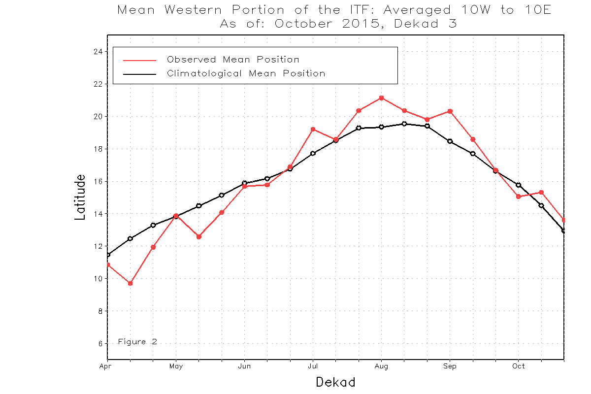
During the period from July 11 - 20, 2007, the African portion of the ITCZ was located near 16.7 degrees north latitude when averaged over the ten day period and from 15W-35E. This compares with a normal position of 17.6N and a position last year of 18.2N. In the west, from 10W-10E, the ITCZ was located near 16.7 degrees north, compared to the long term mean of around 18.7 degrees north, and a position last year of 19.4N. In the east, from 20E-35E, the ITCZ was located near 17.1N, compared with 16.1N for the mean, and 17.2N for last year. The ITCZ continues to move erratically in the west, while in the east it remains above normal.


http://www.cpc.ncep.noaa.gov/products/f ... itcz.shtml
0 likes   

User avatar
cycloneye
Admin
Admin
Posts: 145888
Age: 69
Joined: Thu Oct 10, 2002 10:54 am
Location: San Juan, Puerto Rico

Re: The ITCZ is active and erratic.

#2 Postby cycloneye » Thu Jul 26, 2007 3:54 pm

Yep,what this shows is that crunch time is arriving.
0 likes   

User avatar
hurricanetrack
HurricaneTrack.com
HurricaneTrack.com
Posts: 1781
Joined: Tue Dec 02, 2003 10:46 pm
Location: Wilmington, NC
Contact:

#3 Postby hurricanetrack » Thu Jul 26, 2007 4:32 pm

Gooooooooooooooooooooooood!
0 likes   

User avatar
'CaneFreak
Category 5
Category 5
Posts: 1486
Joined: Mon Jun 05, 2006 10:50 am
Location: New Bern, NC

#4 Postby 'CaneFreak » Thu Jul 26, 2007 4:38 pm

GOOOOOOOOOOOOOOOOOOOOOOOD!!!!!
0 likes   

User avatar
canegrl04
Category 5
Category 5
Posts: 2486
Joined: Thu Aug 26, 2004 5:37 pm
Location: Texas

Re: The ITCZ is active and erratic.

#5 Postby canegrl04 » Thu Jul 26, 2007 9:20 pm

Something I've been meaning to ask for along time. What the hec is ITCZ and how does it figure in the development of storms?
0 likes   

Sanibel
Category 5
Category 5
Posts: 10375
Joined: Mon Aug 30, 2004 11:06 pm
Location: Offshore SW Florida

Re: The ITCZ is active and erratic.

#6 Postby Sanibel » Thu Jul 26, 2007 10:07 pm

ITCZ: Inter Tropical Convergence Zone


It's that belt of clouds across the Atlantic at around 10 latitude. It is the conveyor belt of clouds that exit Africa and form storms. They form there because weather to the north moves west to east and the weather south of the ITCZ is tropical and moves east to west (like hurricane systems). This border causes disruption in the atmosphere that chases up weather systems that form into storms.
0 likes   

User avatar
canegrl04
Category 5
Category 5
Posts: 2486
Joined: Thu Aug 26, 2004 5:37 pm
Location: Texas

Re: The ITCZ is active and erratic.

#7 Postby canegrl04 » Thu Jul 26, 2007 10:49 pm

Thanks,Sanibel :D
0 likes   

User avatar
gatorcane
S2K Supporter
S2K Supporter
Posts: 23692
Age: 47
Joined: Sun Mar 13, 2005 3:54 pm
Location: Boca Raton, FL

Re: The ITCZ is active and erratic.

#8 Postby gatorcane » Fri Jul 27, 2007 9:11 am

Hey Paul it should not be alarming that the ITCZ is erratic. That pink line represents a mean over many years. But if you look at each year individually you would also see erratic behavior.
0 likes   

Frank2
Category 5
Category 5
Posts: 4061
Joined: Mon Jul 25, 2005 12:47 pm

Re: The ITCZ is active and erratic.

#9 Postby Frank2 » Fri Jul 27, 2007 10:00 am

As Steve Lyons mentioned over the last day or two, right now the main feature in the Eastern Atlantic is a monsoon trough - the strong wave mentioned yesterday seems to have merged with this feature:

http://www.ssd.noaa.gov/PS/TROP/DATA/RT/EATL/VIS/20.jpg

other than that, there is a great deal of dry air as shown by the giant field of strato-cu to the northwest of the trough, and, an area of dust just over and off the African coast...
0 likes   

User avatar
vacanechaser
Category 5
Category 5
Posts: 1461
Joined: Wed Dec 03, 2003 9:34 pm
Location: Portsmouth, Va
Contact:

#10 Postby vacanechaser » Fri Jul 27, 2007 10:04 am

Goooooooooooooood!!!

:)

Jesse V. Bass III
http://www.vastormphoto.com
Hurricane Intercept Research Team
0 likes   

User avatar
gatorcane
S2K Supporter
S2K Supporter
Posts: 23692
Age: 47
Joined: Sun Mar 13, 2005 3:54 pm
Location: Boca Raton, FL

Re:

#11 Postby gatorcane » Fri Jul 27, 2007 10:09 am

vacanechaser wrote:Goooooooooooooood!!!

:)

Jesse V. Bass III
http://www.vastormphoto.com
Hurricane Intercept Research Team


Do you mean good or God (here we go) here? :eek: :eek: :eek:
0 likes   

User avatar
vacanechaser
Category 5
Category 5
Posts: 1461
Joined: Wed Dec 03, 2003 9:34 pm
Location: Portsmouth, Va
Contact:

Re: The ITCZ is active and erratic.

#12 Postby vacanechaser » Fri Jul 27, 2007 12:20 pm

Frank2 wrote:As Steve Lyons mentioned over the last day or two, right now the main feature in the Eastern Atlantic is a monsoon trough - the strong wave mentioned yesterday seems to have merged with this feature:

http://www.ssd.noaa.gov/PS/TROP/DATA/RT/EATL/VIS/20.jpg

other than that, there is a great deal of dry air as shown by the giant field of strato-cu to the northwest of the trough, and, an area of dust just over and off the African coast...


i posted this in another thread, but here it is...

Image


the sal, or dust and dry air is not all that bad right now in the atlantic... i have seen much worse... i just dont think sal, or dry air is really a problem...


Jesse V. Bass III
http://www.vastormphoto.com
Hurricane Intercept Research Team
0 likes   

User avatar
vacanechaser
Category 5
Category 5
Posts: 1461
Joined: Wed Dec 03, 2003 9:34 pm
Location: Portsmouth, Va
Contact:

Re:

#13 Postby vacanechaser » Fri Jul 27, 2007 12:22 pm

vacanechaser wrote:Goooooooooooooood!!!

:)

Jesse V. Bass III
http://www.vastormphoto.com
Hurricane Intercept Research Team


Good!!!! here we go... give us something to track... :wink: :lol:


Jesse V. Bass III
http://www.vastormphoto.com
Hurricane Intercept Research Team
0 likes   


Return to “Talkin' Tropics”

Who is online

Users browsing this forum: dl20415, grannyboo and 34 guests