This is the one-Well Defined Wave in East Atlantic

This is the general tropical discussion area. Anyone can take their shot at predicting a storms path.

Moderator: S2k Moderators

Forum rules

The posts in this forum are NOT official forecasts and should not be used as such. They are just the opinion of the poster and may or may not be backed by sound meteorological data. They are NOT endorsed by any professional institution or STORM2K. For official information, please refer to products from the National Hurricane Center and National Weather Service.

Help Support Storm2K
Message
Author
Cyclone1
Category 5
Category 5
Posts: 2739
Age: 33
Joined: Tue Jun 12, 2007 12:03 pm
Location: Florida

Re: Re:

#101 Postby Cyclone1 » Fri Jul 27, 2007 8:14 pm

cycloneye wrote:
Cyclone1 wrote:Whoa are we tracking the remains of COSME? LOL
http://weather.unisys.com/hurricane/e_pacific/2007/COSME/track.gif


You posted in the wrong thread as this one is for the Wave off Africa.


I know, click the link and look at the right side of the track map.
0 likes   

JonathanBelles
Professional-Met
Professional-Met
Posts: 11430
Age: 35
Joined: Sat Dec 24, 2005 9:00 pm
Location: School: Florida State University (Tallahassee, FL) Home: St. Petersburg, Florida
Contact:

Re: Re:

#102 Postby JonathanBelles » Fri Jul 27, 2007 8:20 pm

Cyclone1 wrote:
cycloneye wrote:
Cyclone1 wrote:Whoa are we tracking the remains of COSME? LOL
http://weather.unisys.com/hurricane/e_pacific/2007/COSME/track.gif


You posted in the wrong thread as this one is for the Wave off Africa.


I know, click the link and look at the right side of the track map.


HAHAHAHA :lol: :lol:
0 likes   

User avatar
Blown Away
S2K Supporter
S2K Supporter
Posts: 10160
Joined: Wed May 26, 2004 6:17 am

Re: This is the one-Well Defined Wave off Africa

#103 Postby Blown Away » Fri Jul 27, 2007 8:26 pm

I need this wave to form, I can't handle the shreaded wave or TD disappointment anymore. I want to see a pretty Cane chugging harmlessly across the Atlantic.
0 likes   

User avatar
cycloneye
Admin
Admin
Posts: 145884
Age: 69
Joined: Thu Oct 10, 2002 10:54 am
Location: San Juan, Puerto Rico

Re: This is the one-Well Defined Wave off Africa

#104 Postby cycloneye » Fri Jul 27, 2007 8:26 pm

:uarrow: That is an oops. :)
0 likes   

philnyc
S2K Supporter
S2K Supporter
Posts: 313
Joined: Thu Jun 07, 2007 1:14 am
Location: Brooklyn, New York City, New York
Contact:

Re: Re:

#105 Postby philnyc » Fri Jul 27, 2007 8:40 pm

Cyclone1 wrote:
cycloneye wrote:
Cyclone1 wrote:Whoa are we tracking the remains of COSME? LOL
http://weather.unisys.com/hurricane/e_pacific/2007/COSME/track.gif


You posted in the wrong thread as this one is for the Wave off Africa.


I know, click the link and look at the right side of the track map.


Well I got my laugh of the night.
0 likes   

Brent
S2K Supporter
S2K Supporter
Posts: 38106
Age: 37
Joined: Sun May 16, 2004 10:30 pm
Location: Tulsa Oklahoma
Contact:

Re:

#106 Postby Brent » Fri Jul 27, 2007 10:14 pm

Cyclone1 wrote:Whoa are we tracking the remains of COSME? LOL
http://weather.unisys.com/hurricane/e_pacific/2007/COSME/track.gif


:roflmao:

So we have to rely on EPAC leftovers to get a decent storm. :P
0 likes   

User avatar
HurricaneMaster_PR
Category 2
Category 2
Posts: 795
Joined: Tue Jul 22, 2003 6:23 pm
Location: San Juan, Puerto Rico

Re: This is the one-Well Defined Wave off Africa

#107 Postby HurricaneMaster_PR » Fri Jul 27, 2007 11:06 pm

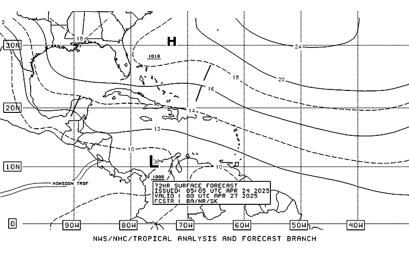
Here's the latest Surface Analysis from the TAFB...Which suggests a 1010mb low during the next 72 hours.

Image
0 likes   

wjs3
S2K Supporter
S2K Supporter
Posts: 633
Joined: Sat Aug 14, 2004 7:57 am

Re: This is the one-Well Defined Wave off Africa

#108 Postby wjs3 » Sat Jul 28, 2007 8:08 am

Phil:

Well there certaily looks to be a good amount of cyclonic turning with the wave. If that hangs around, the convection will come, I think. Sometimes I think convection (in the East Atlantic, anyway) is overrated, but vorticity is underrated.

http://www.meteo.psu.edu/~gadomski/SAT_ ... m8vis.html

Right now lots of stratocu, though, Phil. And I only looked at th GFS really quick. There's no one clear wave that it closes off, but you definitely can see suggestions of "something" going on there.

Talk to you later!

WJS3
0 likes   

philnyc
S2K Supporter
S2K Supporter
Posts: 313
Joined: Thu Jun 07, 2007 1:14 am
Location: Brooklyn, New York City, New York
Contact:

Re: This is the one-Well Defined Wave off Africa

#109 Postby philnyc » Sat Jul 28, 2007 4:21 pm

wjs3 wrote:Phil:

Well there certaily looks to be a good amount of cyclonic turning with the wave. If that hangs around, the convection will come, I think. Sometimes I think convection (in the East Atlantic, anyway) is overrated, but vorticity is underrated.

http://www.meteo.psu.edu/~gadomski/SAT_ ... m8vis.html

Right now lots of stratocu, though, Phil. And I only looked at th GFS really quick. There's no one clear wave that it closes off, but you definitely can see suggestions of "something" going on there.

Talk to you later!

WJS3


Yeah, I'm not overly impressed right now. Clearly the dust situation and SSTs are the single biggest impediments, since the other factors are quite positive, including the strong MLAEJ which is clearly keeping the spin going:
Image

The SAL situation is marginal; it could go either way, although the ample mid-level moisture is counterbalancing that problem right now. Since the LLC appears to be higher in latitude than I would have guessed yesterday (I'd say it's about 13.5 degrees north) that makes the SSTs favorable from 20 to 30 west but really marginal between 30 and 40, then favorable again from 40 westward:

Image

That tells me why the models might be currently showing a closed low popping up at 30W and then disappearing a day or two later. It's still worth watching, IMO, but I don't expect to see much change before Monday or Tuesday. BTW, the GFS and other models DO have a closed low, but it's bouncing all over the place in this morning's runs.
0 likes   

User avatar
Vigilant
Tropical Low
Tropical Low
Posts: 17
Joined: Thu Jun 28, 2007 9:25 am

Re: This is the one-Well Defined Wave off Africa

#110 Postby Vigilant » Sun Jul 29, 2007 12:56 pm

TWD Sunday 2:00 p.m.

Deja vu...


...TROPICAL WAVES...
TROPICAL WAVE IS OVER THE E ATLC ALONG 26W S OF 19N MOVING W
10-15 KT. A WELL DEFINED TROPICAL WAVE IS IN THE VICINITY OF
THE CAPE VERDE ISLANDS WITH GOOD LOW AND MID LEVEL CYCLONIC
TURNING. A NEW SURGE OF AFRICAN DUST HAS BEEN INFUSED INTO THE
WAVE EXTENDING E OF 35W. A STRONG MONSOONAL TROUGH IS NOTED S
OF THE ITCZ ENHANCING THE WAVE. CONVECTION IS CONFINED TO THE
ITCZ. SCATTERED MODERATE CONVECTION IS FROM 8N-10N BETWEEN
25W-29W. ISOLATED MODERATE CONVECTION IS FROM 7N-11N BETWEEN
16W-25W.
0 likes   

User avatar
cycloneye
Admin
Admin
Posts: 145884
Age: 69
Joined: Thu Oct 10, 2002 10:54 am
Location: San Juan, Puerto Rico

Re: This is the one-Well Defined Wave off Africa

#111 Postby cycloneye » Sun Jul 29, 2007 3:14 pm

000
FXCA62 TJSJ 292000
AFDSJU

AREA FORECAST DISCUSSION
NATIONAL WEATHER SERVICE SAN JUAN PR
400 PM AST SUN JUL 29 2007

.DISCUSSION...DRY SUBSIDENT SLOT SHIFTING WNW ACROSS THE LOCAL
AREA TODAY AND ALLOWING FOR LIMITED WEATHER ACROSS THE
ISLANDS...JUST OUT AHEAD OF NEXT TROPICAL WAVE MOVING ACROSS THE
LESSER ANTILLES...AND ASSOCIATED MOISTURE FIELD. SCATTERED SHOWERS
WILL MOVE INTO THE AREA FROM THE EAST THIS EVENING...AND SPREAD
INTO EASTERN PR BY AROUND MIDNIGHT...WITH ISOLATED TSTORMS DOTTING
THE LOCAL WATERS OVERNIGHT. GFS AND NAM SUGGEST BEST MOISTURE AND
MORE NUMEROUS WEATHER TO PASS JUST NORTH OF THE LOCAL AREA
OVERNIGHT THROUGH MONDAY NOON OR SO.

BEYOND THIS TIME FRAME...I HAVE SOME RESERVATIONS IN GFS HANDLING
OF ATLC TROPICAL WAVES...AND HAVE CHOSEN NOT TO ALTER THE FORECAST
FOR NOW. UKMET SEEMS TO BE DOING A BIT BETTER WITH NEXT WAVE IN
THE 40S...ALTHOUGH I HAVE UKMET GUIDANCE AVAILABLE OUT ONLY TO 72
HRS. BROAD AND WELL DEFINED AFRICAN MONSOON CIRCULATION
CONTINUES... WITH NARROW MONSOON TROF EXTENDING WWD OFF THE W
AFRICAN BULGE. THIS RELATIVELY DEEP AND NARROW TROF ACTING TO
ELONGATED ZONALLY THE VORTICITY FIELDS OF TROPICAL WAVES THE PAST
SEVERAL DAYS...AND VORT LOBES ARE FRACTURING OFF TO THE NW...AND
LEAVING SLOWER MOVING VORTS EMBEDDED WITHIN THE TROF...SOMEWHAT
LIKE LAST YEAR BUT TO A LESSER EXTREME. GFS IS NOT INITIALIZING
THE VORT CENTER ALONG 10N 42.5W WELL...AND I AM NOT COMFORTABLE
WITH THE MODEL INCONSISTENCY. WITH THE GFS BEING OUR RICE AND
BEANS MODEL BEYOND 24-36 HRS...I AM HOLDING OFF ANY CHANGES TO SEE
WHAT EVOLVES WITH THIS WAVE. GFS IS FORECASTING AN AEJ SEGMENT AND
VORT LOBE TO SHEAR OFF AND MOVE THROUGH THE REGIONAL CARIB TUE-
TUES NIGHT AND EXPECT SHALLOW BUT SQUALLY WEATHER ACROSS THE LOCAL
CARIB WATERS WITH THIS.

GFS STILL SUGGESTING MORE FREQUENCY OF PASSING DEEP LAYERED WAVE
RELATED MOISTURE NEXT 7-10 DAYS...IN CONTRAST TO CLIMATOLOGY AND
THE CARIB MID SUMMER DROUGHT...WHICH SEEMS TO HAVE OCCURRED
REGIONALLY JUNE- JULY RATHER THAN JULY-AUGUST.


Interesting the discussion this afternoon from the San Juan NWS about what is going on with the monsoon trough and the models for the next 7-10 days..
0 likes   

philnyc
S2K Supporter
S2K Supporter
Posts: 313
Joined: Thu Jun 07, 2007 1:14 am
Location: Brooklyn, New York City, New York
Contact:

Re: This is the one-Well Defined Wave off Africa

#112 Postby philnyc » Sun Jul 29, 2007 3:35 pm

cycloneye wrote:000
FXCA62 TJSJ 292000
AFDSJU

AREA FORECAST DISCUSSION
NATIONAL WEATHER SERVICE SAN JUAN PR
400 PM AST SUN JUL 29 2007

.DISCUSSION...DRY SUBSIDENT SLOT SHIFTING WNW ACROSS THE LOCAL
AREA TODAY AND ALLOWING FOR LIMITED WEATHER ACROSS THE
ISLANDS...JUST OUT AHEAD OF NEXT TROPICAL WAVE MOVING ACROSS THE
LESSER ANTILLES...AND ASSOCIATED MOISTURE FIELD. SCATTERED SHOWERS
WILL MOVE INTO THE AREA FROM THE EAST THIS EVENING...AND SPREAD
INTO EASTERN PR BY AROUND MIDNIGHT...WITH ISOLATED TSTORMS DOTTING
THE LOCAL WATERS OVERNIGHT. GFS AND NAM SUGGEST BEST MOISTURE AND
MORE NUMEROUS WEATHER TO PASS JUST NORTH OF THE LOCAL AREA
OVERNIGHT THROUGH MONDAY NOON OR SO.

BEYOND THIS TIME FRAME...I HAVE SOME RESERVATIONS IN GFS HANDLING
OF ATLC TROPICAL WAVES...AND HAVE CHOSEN NOT TO ALTER THE FORECAST
FOR NOW. UKMET SEEMS TO BE DOING A BIT BETTER WITH NEXT WAVE IN
THE 40S...ALTHOUGH I HAVE UKMET GUIDANCE AVAILABLE OUT ONLY TO 72
HRS. BROAD AND WELL DEFINED AFRICAN MONSOON CIRCULATION
CONTINUES... WITH NARROW MONSOON TROF EXTENDING WWD OFF THE W
AFRICAN BULGE. THIS RELATIVELY DEEP AND NARROW TROF ACTING TO
ELONGATED ZONALLY THE VORTICITY FIELDS OF TROPICAL WAVES THE PAST
SEVERAL DAYS...AND VORT LOBES ARE FRACTURING OFF TO THE NW...AND
LEAVING SLOWER MOVING VORTS EMBEDDED WITHIN THE TROF...SOMEWHAT
LIKE LAST YEAR BUT TO A LESSER EXTREME. GFS IS NOT INITIALIZING
THE VORT CENTER ALONG 10N 42.5W WELL...AND I AM NOT COMFORTABLE
WITH THE MODEL INCONSISTENCY. WITH THE GFS BEING OUR RICE AND
BEANS MODEL BEYOND 24-36 HRS...I AM HOLDING OFF ANY CHANGES TO SEE
WHAT EVOLVES WITH THIS WAVE. GFS IS FORECASTING AN AEJ SEGMENT AND
VORT LOBE TO SHEAR OFF AND MOVE THROUGH THE REGIONAL CARIB TUE-
TUES NIGHT AND EXPECT SHALLOW BUT SQUALLY WEATHER ACROSS THE LOCAL
CARIB WATERS WITH THIS.

GFS STILL SUGGESTING MORE FREQUENCY OF PASSING DEEP LAYERED WAVE
RELATED MOISTURE NEXT 7-10 DAYS...IN CONTRAST TO CLIMATOLOGY AND
THE CARIB MID SUMMER DROUGHT...WHICH SEEMS TO HAVE OCCURRED
REGIONALLY JUNE- JULY RATHER THAN JULY-AUGUST.


Interesting the discussion this afternoon from the San Juan NWS about what is going on with the monsoon trough and the models for the next 7-10 days..


Very interesting. Thanks for posting that. You can learn a lot about what's going on from these guys. I especially liked the explanation of the monsoon trough elongating the vorticity of waves coming off Africa. I had noticed it on the satellite loops, where the circulation of the waves was getting stretched along an east-west axis, but didn't know what was causing it. It will be interesting to see if that happens to the wave at 25 degrees also.
0 likes   

philnyc
S2K Supporter
S2K Supporter
Posts: 313
Joined: Thu Jun 07, 2007 1:14 am
Location: Brooklyn, New York City, New York
Contact:

Re: This is the one-Well Defined Wave off Africa

#113 Postby philnyc » Sun Jul 29, 2007 4:30 pm

Do you see that area of convection approaching the African coast and the strong wave near 25 degrees? The convective area looks like a decaying MCS from last night, and it's moving faster than the wave (I assume because the circulation is higher up in the faster flow at 500mb or higher). Does anyone know what kind of interaction they normally have? I don't recall seeing this before, or at least I still hadn't graduated from school the last time I saw this and didn't know what I was looking at...

http://www.meteo.psu.edu/rtwx/ewall/SAT_TROPATLEAST/anim8ir.html
0 likes   

OURAGAN
Category 1
Category 1
Posts: 455
Joined: Sat Aug 07, 2004 12:18 pm
Location: GUADELOUPE

Re: This is the one-Well Defined Wave off Africa

#114 Postby OURAGAN » Sun Jul 29, 2007 5:40 pm

The wave at 26 W begins to organize,what do you think about it?

http://www.nrlmry.navy.mil/sat-bin/disp ... C_SCALE=15
0 likes   

philnyc
S2K Supporter
S2K Supporter
Posts: 313
Joined: Thu Jun 07, 2007 1:14 am
Location: Brooklyn, New York City, New York
Contact:

Re: This is the one-Well Defined Wave off Africa

#115 Postby philnyc » Sun Jul 29, 2007 5:49 pm

OURAGAN wrote:The wave at 26 W begins to organize,what do you think about it?

http://www.nrlmry.navy.mil/sat-bin/disp ... C_SCALE=15


Looks like it might break free of the ITCZ over the next day or two. The models are quite divergent - either have it as a broad low by tomorrow/Tuesday or an open wave. The actual atmospheric conditions are still marginal, and SSTs between 30 and 40 degrees west and 14 degrees north are slightly below 26.5 C. If it makes it past 40 degrees west, conditions good for development will improve.
0 likes   

philnyc
S2K Supporter
S2K Supporter
Posts: 313
Joined: Thu Jun 07, 2007 1:14 am
Location: Brooklyn, New York City, New York
Contact:

Re: This is the one-Well Defined Wave in East Atlantic

#116 Postby philnyc » Mon Jul 30, 2007 1:43 am

If this wave makes it to 40 degrees west with that kind of circulation, watch out!

Image

At this point, it still has no negatives other than marginal SSTs until 40 west, and a moderate amount of SAL, which is often not a storm-killer when other conditions are positive.

As someone else said in here (forgot who), this has a very large "envelope".
0 likes   

User avatar
HurricaneMaster_PR
Category 2
Category 2
Posts: 795
Joined: Tue Jul 22, 2003 6:23 pm
Location: San Juan, Puerto Rico

Re: This is the one-Well Defined Wave in East Atlantic

#117 Postby HurricaneMaster_PR » Mon Jul 30, 2007 10:29 am

Dont forget about this one...It now counts with a 1009mb low

12Z Surface Analysis
Image
0 likes   

Cyclone1
Category 5
Category 5
Posts: 2739
Age: 33
Joined: Tue Jun 12, 2007 12:03 pm
Location: Florida

#118 Postby Cyclone1 » Mon Jul 30, 2007 10:30 am

Could we have an Erin by Wednesday?
0 likes   

philnyc
S2K Supporter
S2K Supporter
Posts: 313
Joined: Thu Jun 07, 2007 1:14 am
Location: Brooklyn, New York City, New York
Contact:

Re:

#119 Postby philnyc » Mon Jul 30, 2007 11:12 am

Cyclone1 wrote:Could we have an Erin by Wednesday?


No, but by early next week it could definitely happen. Sure looks like future Chantal at 9N 44W, Dean at 11N 27W and another coming off the coast now.

Image

The first two waves already have LL and ML centers. The first will have to gain some more latitude, and the 11,27 wave should really pop once it passes about 35W or so.

Oops, I forgot. If 98L makes it to Chantal, then would be Dean and Erin up above. OBVIOUSLY it's still too soon and this is just fun to speculate, but the 9N44W wave has just been named an area of interest:


http://www.nhc.noaa.gov/gtwo_atl.shtml
Last edited by philnyc on Mon Jul 30, 2007 11:21 am, edited 1 time in total.
0 likes   

User avatar
gatorcane
S2K Supporter
S2K Supporter
Posts: 23692
Age: 47
Joined: Sun Mar 13, 2005 3:54 pm
Location: Boca Raton, FL

Re: This is the one-Well Defined Wave in East Atlantic

#120 Postby gatorcane » Mon Jul 30, 2007 11:15 am

me thinks the AFRICAN WAVE TRAIN is nearly here... :eek:
0 likes   


Return to “Talkin' Tropics”

Who is online

Users browsing this forum: Google [Bot] and 19 guests