INVEST 99L,East of Windwards
Moderator: S2k Moderators
Forum rules

The posts in this forum are NOT official forecasts and should not be used as such. They are just the opinion of the poster and may or may not be backed by sound meteorological data. They are NOT endorsed by any professional institution or STORM2K. For official information, please refer to products from the National Hurricane Center and National Weather Service.

-
wxman57

- Moderator-Pro Met

- Posts: 23175
- Age: 68
- Joined: Sat Jun 21, 2003 8:06 pm
- Location: Houston, TX (southwest)
Re:
punkyg wrote:How come wxman57 is the only pro met talking about 99L?
Most of the other pro mets here may not have the tropics as their prime area of concern. They comment when they can, but the tropics may not be their main responsibility.
0 likes
-
'CaneFreak

- Category 5

- Posts: 1487
- Joined: Mon Jun 05, 2006 10:50 am
- Location: New Bern, NC
Re: Re:
wxman57 wrote:punkyg wrote:How come wxman57 is the only pro met talking about 99L?
Most of the other pro mets here may not have the tropics as their prime area of concern. They comment when they can, but the tropics may not be their main responsibility.
Well, I love your commentary. You do an stand up job. Keep up the good work!!!! We really appreciate it.
0 likes
-
stormy70
Re: Re:
Cyclone1 wrote:CrazyC83 wrote:Could we have Chantal AND Dean in the week ahead?
I would say, yes. Which is why I laugh at season cancelers. Just last night people were canceling 2007.
Don't people know it is only July and we haven't even got into August and Sept. This is a normal year so far. I don't expect to see a lot of action until mid August and Sept.
0 likes

Re: INVEST 99L: 11:30 TWO says 'slow development possible'
I could be totally wrong, but two nights ago I looked at GFS at 72 hours and it had a low about where we're talking about. I didn't save the screen. Did anybody else see that?
I like that shallow BAMM track. If something develops, can anyone say whether there is anything upstream that would tend to let it go farther north?
Also I second the kudos for Wxman57's insight. Keep it up! Great to have something to watch.
I like that shallow BAMM track. If something develops, can anyone say whether there is anything upstream that would tend to let it go farther north?
Also I second the kudos for Wxman57's insight. Keep it up! Great to have something to watch.
0 likes
I have yet to see a post that says "season cancelled", I have seen people say that it wont be as active as once predicted. Just imagine if we had zero named storms now, which we were very close to having. Season totals would be lowered.
I think its just as laughable to see people who say we will have two more named storms by weeks end as people who say, this season will produce lower numbers.
I think its just as laughable to see people who say we will have two more named storms by weeks end as people who say, this season will produce lower numbers.
0 likes


Re: Floater 2 on INVEST 99L in C. ATL - possible recon (thread 2
wxman57 wrote:BAMS moves it at supersonic speed to the middle Gulf in 5 days, not very likely.
BAMS is not a model. It uses the current surface wind data and says that if they don't change one bit for the next five days and the storm is only directed by the surface winds, where would it end up. As you can see, that's a pretty unreliable forecast--as the surface winds are constantly changing, and storms are not directed by only one or the other atmospheric layer. It does give a weak indication however of where something might go--at least until the dynamic models start picking up on it. Personally, I agree with your prediction of it being south of Jamaica.
Last edited by vaffie on Mon Jul 30, 2007 10:20 am, edited 1 time in total.
0 likes
-
alan1961

- Category 2

- Posts: 771
- Joined: Mon Mar 20, 2006 11:58 am
- Location: Derby, Derbyshire, England
- Contact:
Re: INVEST 99L: 11:30 TWO says 'slow development possible'
Think that area behind it is showing some signs of development too.
0 likes
-
'CaneFreak
- Category 5
- Posts: 1487
- Joined: Mon Jun 05, 2006 10:50 am
- Location: New Bern, NC
This will be the invest I personally will be watching over the next several days. This invest has the classic envelope of many major hurricanes that have blossomed over the past several years. Frances, Jeanne, and Ivan are very vivid in my mind. They all started with this same envelope and a MLC amongst all this convection. I will be monitoring this one especially over the next several days.
0 likes
-
cnflstormchaser
- Tropical Wave

- Posts: 3
- Joined: Mon Jul 30, 2007 7:42 am
Re: INVEST 99L: 11:30 TWO says 'slow development possible'
Looking at the model forcasts for this storm, and this could certainly change. If this holds together its got a bee line for the nw carribean which is where some of the warmest sea surface temps exist. Could spell trouble if you can get a cyclone in a low sheer enviorment over those waters. Just speculation at this point, but atleast we have something to legit to watch. Game on!!!
0 likes
-
alan1961
- Category 2
- Posts: 771
- Joined: Mon Mar 20, 2006 11:58 am
- Location: Derby, Derbyshire, England
- Contact:
Re:
'CaneFreak wrote:This will be the invest I personally will be watching over the next several days. This invest has the classic envelope of many major hurricanes that have blossomed over the past several years. Frances, Jeanne, and Ivan are very vivid in my mind. They all started with this same envelope and a MLC amongst all this convection. I will be monitoring this one especially over the next several days.
yes agree entirely cane..it has that classic look about it even at this early stage..if this one dont get its act together i'll spit at the screen..hehe
0 likes
Re: INVEST 99L: 11:30 TWO says 'slow development possible'
Should it enter the Gulf as a tropical something, it is worth reading this Austin, TX discussion of what the Gulf of Mexico might be like come the weekend.
000 FXUS64 KEWX 301128 AAA AFDEWX AREA FORECAST DISCUSSION...UPDATED NATIONAL WEATHER SERVICE AUSTIN/SAN ANTONIO TX 628 AM CDT MON JUL 30 2007 .AVIATION... CONDITIONS ARE CURRENTLY MVFR...BUT WILL MIX WITH IFR CIGS/VSBYS THROUGH 14-15Z BEFORE GOING VFR ACROSS THE AREA. THUNDERSTORMS ARE FORECAST AT THE KDRT TERMINAL BETWEEN 12-16Z...THEN AGAIN LATE IN THE TAF PERIOD. MVFR CIGS WILL RETURN TO TERMINALS BETWEEN 06-09Z TUESDAY MORNING. && .PREV DISCUSSION... /ISSUED 411 AM CDT MON JUL 30 2007/ DISCUSSION... WILL LET THE FFA EXPIRE AT 7 AM AS THE POTENTIAL FOR EARLY MORNING HEAVY RAINS CONTINUES, BUT HAS BEEN FOCUSED MAINLY WEST OF THE RIO GRANDE. GFS AND NAM SHOW GOOD AGREEMENT ON WARMING MID-LEVEL TEMPS COINCIDING WITH DECREASING MID-LEVEL MOISTURE ACROSS THE WESTERN COUNTIES. MOISTURE LEVELS WILL STILL REMAIN HIGH AND THE THREAT FOR ISOLATED HEAVY RAINS WILL CONTINUE TODAY, BUT FLASH FLOODING WOULD BE MORE DEPENDENT ON TRAINING DUE TO INCREASED CELL SPEEDS IN A DEEPER SOUTHERLY FLOW. THUS WILL KEEP IN SOME GOOD RAIN CHANCES HILL COUNTRY AND WESTERN COUNTIES WITH A MENTION OF LOCALLY HEAVY RAINFALL. MOST MODEL DATA SHOWS A RETURN TO MORE SEASONAL CONDITIONS TUESDAY INTO THURSDAY WITH TYPICAL 20-30 POPS EACH DAY, INCREASING TO MOSTLY 30 POPS LATE THURSDAY INTO FRIDAY WHEN MODELS SHOW ANOTHER MID-LEVEL IMPULSE DROPPING SW FROM NE TX. THIS IMPULSE LOOKS LESS SIGNIFICANT THAN THE PREVIOUS SHORTWAVES THAT PRODUCED THE REPETITIVE FLOOD EVENTS IN JULY. MODELS ARE TRENDING TOWARD THE BUILDING AN UPPER RIDGE OVER THE GULF STATES OVER THE WEEKEND WHICH SHOULD FURTHER INCREASE STABILITY. HOWEVER, THIS PATTERN COULD BE MORE FAVORABLE FOR TROPICAL DEVELOPMENT HEADING INTO NEXT WEEK.
000 FXUS64 KEWX 301128 AAA AFDEWX AREA FORECAST DISCUSSION...UPDATED NATIONAL WEATHER SERVICE AUSTIN/SAN ANTONIO TX 628 AM CDT MON JUL 30 2007 .AVIATION... CONDITIONS ARE CURRENTLY MVFR...BUT WILL MIX WITH IFR CIGS/VSBYS THROUGH 14-15Z BEFORE GOING VFR ACROSS THE AREA. THUNDERSTORMS ARE FORECAST AT THE KDRT TERMINAL BETWEEN 12-16Z...THEN AGAIN LATE IN THE TAF PERIOD. MVFR CIGS WILL RETURN TO TERMINALS BETWEEN 06-09Z TUESDAY MORNING. && .PREV DISCUSSION... /ISSUED 411 AM CDT MON JUL 30 2007/ DISCUSSION... WILL LET THE FFA EXPIRE AT 7 AM AS THE POTENTIAL FOR EARLY MORNING HEAVY RAINS CONTINUES, BUT HAS BEEN FOCUSED MAINLY WEST OF THE RIO GRANDE. GFS AND NAM SHOW GOOD AGREEMENT ON WARMING MID-LEVEL TEMPS COINCIDING WITH DECREASING MID-LEVEL MOISTURE ACROSS THE WESTERN COUNTIES. MOISTURE LEVELS WILL STILL REMAIN HIGH AND THE THREAT FOR ISOLATED HEAVY RAINS WILL CONTINUE TODAY, BUT FLASH FLOODING WOULD BE MORE DEPENDENT ON TRAINING DUE TO INCREASED CELL SPEEDS IN A DEEPER SOUTHERLY FLOW. THUS WILL KEEP IN SOME GOOD RAIN CHANCES HILL COUNTRY AND WESTERN COUNTIES WITH A MENTION OF LOCALLY HEAVY RAINFALL. MOST MODEL DATA SHOWS A RETURN TO MORE SEASONAL CONDITIONS TUESDAY INTO THURSDAY WITH TYPICAL 20-30 POPS EACH DAY, INCREASING TO MOSTLY 30 POPS LATE THURSDAY INTO FRIDAY WHEN MODELS SHOW ANOTHER MID-LEVEL IMPULSE DROPPING SW FROM NE TX. THIS IMPULSE LOOKS LESS SIGNIFICANT THAN THE PREVIOUS SHORTWAVES THAT PRODUCED THE REPETITIVE FLOOD EVENTS IN JULY. MODELS ARE TRENDING TOWARD THE BUILDING AN UPPER RIDGE OVER THE GULF STATES OVER THE WEEKEND WHICH SHOULD FURTHER INCREASE STABILITY. HOWEVER, THIS PATTERN COULD BE MORE FAVORABLE FOR TROPICAL DEVELOPMENT HEADING INTO NEXT WEEK.
0 likes
-
'CaneFreak
- Category 5
- Posts: 1487
- Joined: Mon Jun 05, 2006 10:50 am
- Location: New Bern, NC
http://www.ssd.noaa.gov/PS/TROP/DATA/RT ... SWD/20.jpg
Already getting satellite estimates of 28 knots just outside of a few raincontaminated bands of convection on the east and southerly sides of the MLC.
Already getting satellite estimates of 28 knots just outside of a few raincontaminated bands of convection on the east and southerly sides of the MLC.
0 likes
-
miamicanes177
- Category 5
- Posts: 1131
- Joined: Tue Aug 01, 2006 10:53 pm
Re: INVEST 99L: 11:30 TWO says 'slow development possible'
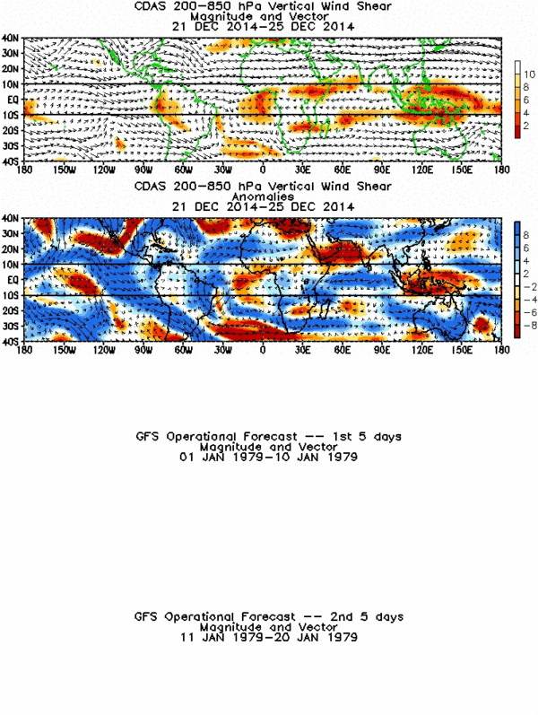
Look at the bottom two graphs for the forecast shear. Pay particular attention to the bottom graph for August 4-8. That is very favorable wind shear. The Atlantic and 99L could get very serious really fast.
http://www.cpc.ncep.noaa.gov/products/precip/CWlink/MJO/combined_shear_2.gif
http://www.cpc.ncep.noaa.gov/products/precip/CWlink/MJO/combined_shear_2.gif
0 likes
-
gatorcane

- S2K Supporter

- Posts: 23708
- Age: 48
- Joined: Sun Mar 13, 2005 3:54 pm
- Location: Boca Raton, FL
Re: INVEST 99L: 11:30 TWO says 'slow development possible'
miamicanes177 wrote:Look at the bottom two graphs for the forecast shear. Pay particular attention to the bottom graph for August 4-8. That is very favorable wind shear. The Atlantic and 99L could get very serious really fast.
http://www.cpc.ncep.noaa.gov/products/precip/CWlink/MJO/combined_shear_2.gif
Yeah I certainly think we are going to have big problem on our hands....for the U.S. case perhaps it will be a low tracker and stay south of us.....but remember keep in mind the NW Caribbean has hotter water temps than even 2005.....its ready to be tapped...
Again as Wxman says if it gains strength more quickly we should see it gain some lattitude....but if it slowly develops over the next week it should take a more shallow BAM track putting it south of Jamaica as Wxman says.
Last edited by gatorcane on Mon Jul 30, 2007 10:32 am, edited 1 time in total.
0 likes
-
Blown Away

- S2K Supporter
- Posts: 10253
- Joined: Wed May 26, 2004 6:17 am
Re: INVEST 99L: 11:30 TWO says 'slow development possible'
For South Florida I think the next 24 hours is critical, if 99L develops faster it will gain latitude faster, if it does not develop as indicated by the models 99L will continue moving more W into the Carribean and become a potential Mexico/Gulf problem more than a SFL problem.
0 likes
-
gatorcane
- S2K Supporter
- Posts: 23708
- Age: 48
- Joined: Sun Mar 13, 2005 3:54 pm
- Location: Boca Raton, FL
Re: INVEST 99L: 11:30 TWO says 'slow development possible'
Blown_away wrote:For South Florida I think the next 24 hours is critical, if 99L develops faster it will gain latitude faster, if it does not develop as indicated by the models 99L will continue moving more W into the Carribean and become a potential Mexico/Gulf problem more than a SFL problem.
Agreed...for south floridians we need to make sure that center doesn't form a little farther north.....but as always we probably will be in the cone of uncertainty be default....as we always are......
0 likes

Re: INVEST 99L: 11:30 TWO says 'slow development possible'
Don't forget if the east coast trough persists longer than expected a Charley or Dennis track could happen.Models have been trying to build the bermuda high west for a week and a half now. The trough doesn't want to give up his new home yet. Lets see what happens later in the week with the prediction of the bermuda high building back.
0 likes
Who is online
Users browsing this forum: No registered users and 229 guests