99L Thread 7: Data, Analyses, Interpretations, Conclusions

This is the general tropical discussion area. Anyone can take their shot at predicting a storms path.

Moderator: S2k Moderators

Forum rules

The posts in this forum are NOT official forecasts and should not be used as such. They are just the opinion of the poster and may or may not be backed by sound meteorological data. They are NOT endorsed by any professional institution or STORM2K. For official information, please refer to products from the National Hurricane Center and National Weather Service.

Help Support Storm2K
Message
Author
User avatar
wxmann_91
Category 5
Category 5
Posts: 8013
Age: 34
Joined: Fri Jul 15, 2005 2:49 pm
Location: Southern California
Contact:

99L Thread 7: Data, Analyses, Interpretations, Conclusions

#1 Postby wxmann_91 » Fri Aug 03, 2007 3:30 pm

0 likes   

User avatar
SouthFloridawx
S2K Supporter
S2K Supporter
Posts: 8346
Age: 46
Joined: Tue Jul 26, 2005 1:16 am
Location: Sarasota, FL
Contact:

Re: 99L Thread 7: Data, Analyses, Interpretations, Conclusions

#2 Postby SouthFloridawx » Fri Aug 03, 2007 3:41 pm

As I said before this should move right into C. America/S. Yuck Pen.

Image
0 likes   

User avatar
wxman57
Moderator-Pro Met
Moderator-Pro Met
Posts: 22991
Age: 67
Joined: Sat Jun 21, 2003 8:06 pm
Location: Houston, TX (southwest)

Re: 99L Thread 7: Data, Analyses, Interpretations, Conclusions

#3 Postby wxman57 » Fri Aug 03, 2007 3:52 pm

skysummit wrote:I'm not sure if this means much right now or not, but may help support my theory I posted earlier in this thread. Over the past 6 hours, surface convergence has been increasing a little in and around the Yucatan Channel. This may aid in convective development later this evening and tonight.

I would still like a pro met to give opinions on the map and theory I posted earlier today.


I didn't see your earlier post with any map, but convergence is definitely increasing (as is convection) as of 4pm CDT. Quite a blow-up north of the area of lower pressure. It's behaving very much as I expected as it begins to slow down in the western Caribbean. Might need that invest back by tomorrow morning. Belize appears to have a bullseye on it, then across the southern or central BoC to Mexico. Ridge building over northern Gulf should prevent any turn to the north. Interaction with the Yucatan and limited time over water should prevent this from becoming anything more than a TS (if that).
0 likes   

User avatar
vaffie
Category 3
Category 3
Posts: 898
Joined: Sat Sep 11, 2004 5:11 pm
Location: Houston, Texas

#4 Postby vaffie » Fri Aug 03, 2007 3:57 pm

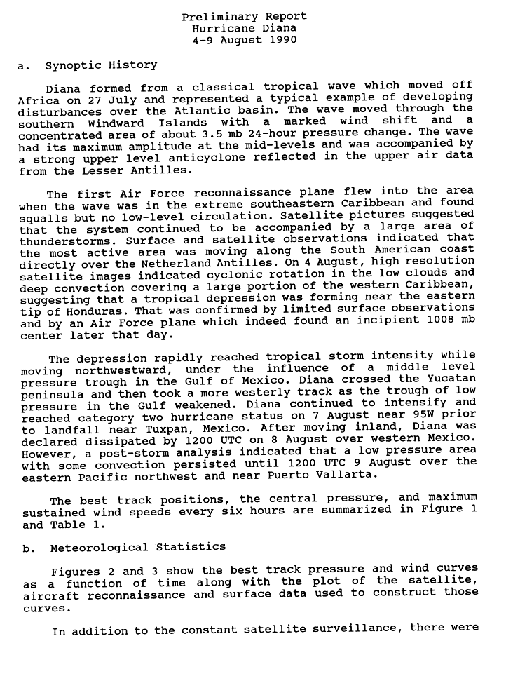
punkyg wrote:I can't wait for tonight. who thinks this will fire up some more convection.


there's no doubt that it will keep refiring convection. The question is how much organized development will occur. I lean towards further development, but it won't necessarily happen. There has to be a lot of convergence for one, and there has to be a focus--it can't just happen over a very broad area like it is right now. If it does occur over a broad area however, it has to last for a long time. It is definitely a windy, stormy system with potential--will it become a threatening system remains an open question. The NW Caribbean will hold a lot of potential for it. Just the act of slowing down will result in mild convergence, an upper level high is forecast to form there in the next two days, and the waters are incredibly warm and untouched--so it will have all the ingredients it needs--convergence at the surface, divergence at the upper levels, and moist air throughout. We'll just have to see what comes out.
0 likes   

whereverwx
Category 5
Category 5
Posts: 1109
Joined: Mon May 31, 2004 10:15 pm

Re: 99L Thread 7: Data, Analyses, Interpretations, Conclusions

#5 Postby whereverwx » Fri Aug 03, 2007 3:58 pm

Here's a nice afternoon visible of the disturbance.

Image
0 likes   

User avatar
NONAME
Category 1
Category 1
Posts: 373
Age: 35
Joined: Sat Mar 18, 2006 8:15 am
Location: Where the Wind Blows

#6 Postby NONAME » Fri Aug 03, 2007 3:58 pm

Wow it does have some hope for development now.
0 likes   

weatherguru18

Re: 99L Thread 7: Data, Analyses, Interpretations, Conclusions

#7 Postby weatherguru18 » Fri Aug 03, 2007 4:00 pm

Check this out gang...Frank pointed out that the tropical heat potential in the western caribbean sea is warm and undisturbed. As this system approaches and slows, coupled with weak shear, this thing will have optimal conditions to pop. I'm not counting this dead yet. Right now it's sitting over "cool" water. You have the convergant asymptote and an anti-cyclonic spin, it just needs a minute to catch it's breath as it slows down.

http://www.aoml.noaa.gov/phod/dataphod1 ... 7214ca.jpg
0 likes   

User avatar
cheezyWXguy
Category 5
Category 5
Posts: 6110
Joined: Mon Feb 13, 2006 12:29 am
Location: Dallas, TX

Re: 99L Thread 7: Data, Analyses, Interpretations, Conclusions

#8 Postby cheezyWXguy » Fri Aug 03, 2007 4:01 pm

calamity wrote:Here's a nice afternoon visible of the disturbance.

Image


That picture is a bit old, if yall are seeing the same pic i am...maybe my computer isnt refreshing properly...
0 likes   

User avatar
SouthFloridawx
S2K Supporter
S2K Supporter
Posts: 8346
Age: 46
Joined: Tue Jul 26, 2005 1:16 am
Location: Sarasota, FL
Contact:

Re: 99L Thread 7: Data, Analyses, Interpretations, Conclusions

#9 Postby SouthFloridawx » Fri Aug 03, 2007 4:01 pm

Image
0 likes   

User avatar
Lowpressure
S2K Supporter
S2K Supporter
Posts: 2032
Age: 58
Joined: Sun Sep 14, 2003 9:17 am
Location: Charlotte, North Carolina

Re: 99L Thread 7: Data, Analyses, Interpretations, Conclusions

#10 Postby Lowpressure » Fri Aug 03, 2007 4:01 pm

This thing just flew across the Carib.
0 likes   

User avatar
SouthFloridawx
S2K Supporter
S2K Supporter
Posts: 8346
Age: 46
Joined: Tue Jul 26, 2005 1:16 am
Location: Sarasota, FL
Contact:

Re: 99L Thread 7: Data, Analyses, Interpretations, Conclusions

#11 Postby SouthFloridawx » Fri Aug 03, 2007 4:02 pm

Doesn't have much time... maybe another 24 hours or so.
0 likes   

RL3AO
Moderator-Pro Met
Moderator-Pro Met
Posts: 16308
Joined: Thu Jun 14, 2007 10:03 pm
Location: NC

#12 Postby RL3AO » Fri Aug 03, 2007 4:02 pm

An early blowup. It didn't start until around midnight ET yesterday.
0 likes   

whereverwx
Category 5
Category 5
Posts: 1109
Joined: Mon May 31, 2004 10:15 pm

Re: 99L Thread 7: Data, Analyses, Interpretations, Conclusions

#13 Postby whereverwx » Fri Aug 03, 2007 4:04 pm

cheezyWXguy wrote:
calamity wrote:Here's a nice afternoon visible of the disturbance.

http://img383.imageshack.us/img383/5810/99lyc1.jpg


That picture is a bit old, if yall are seeing the same pic i am...maybe my computer isnt refreshing properly...

Oh... that is actually two hours old. I didn't notice that.
0 likes   

User avatar
SouthFloridawx
S2K Supporter
S2K Supporter
Posts: 8346
Age: 46
Joined: Tue Jul 26, 2005 1:16 am
Location: Sarasota, FL
Contact:

Re: 99L Thread 7: Data, Analyses, Interpretations, Conclusions

#14 Postby SouthFloridawx » Fri Aug 03, 2007 4:04 pm

calamity wrote:
cheezyWXguy wrote:
calamity wrote:Here's a nice afternoon visible of the disturbance.
http://img383.imageshack.us/img383/5810/99lyc1.jpg

That picture is a bit old, if yall are seeing the same pic i am...maybe my computer isnt refreshing properly...

Oh... that is actually two hours old. I didn't notice that.

Geez Calamity come on... Whats up with that? :lol: :wink:
0 likes   

superfly

Re: 99L Thread 7: Data, Analyses, Interpretations, Conclusions

#15 Postby superfly » Fri Aug 03, 2007 4:07 pm

It'll be under 20-30 kts shear until about 85W when it'll have a small window of opportunity to organize, but I'm not sure it will be near enough time with the type of speed it's moving at.

Image
0 likes   

User avatar
HURAKAN
Professional-Met
Professional-Met
Posts: 46086
Age: 38
Joined: Thu May 20, 2004 4:34 pm
Location: Key West, FL
Contact:

#16 Postby HURAKAN » Fri Aug 03, 2007 4:11 pm

Image

Image

I know it's not the same situation but Diana, 1990, seems to be a good example to what could happen to 99L. Diana, 1990, reached cat. 2 and we don't know if 99L could reach that intensity.
0 likes   

User avatar
HURAKAN
Professional-Met
Professional-Met
Posts: 46086
Age: 38
Joined: Thu May 20, 2004 4:34 pm
Location: Key West, FL
Contact:

#17 Postby HURAKAN » Fri Aug 03, 2007 4:21 pm

TROPICAL WEATHER OUTLOOK
NWS TPC/NATIONAL HURRICANE CENTER MIAMI FL
530 PM EDT FRI AUG 3 2007

FOR THE NORTH ATLANTIC...CARIBBEAN SEA AND THE GULF OF MEXICO...

A TROPICAL WAVE OVER THE WESTERN CARIBBEAN SEA IS MOVING RAPIDLY
WESTWARD AND IS EXPECTED TO BRING CLOUDINESS AND SHOWERS TO
JAMAICA...THE CAYMAN ISLANDS AND PORTIONS OF CENTRAL AMERICA
TONIGHT AND SATURDAY. UPPER-LEVEL WINDS MAY BECOME A LITTLE MORE
FAVORABLE FOR DEVELOPMENT DURING THE NEXT DAY OR SO...BUT
DEVELOPMENT MAY BE HINDERED BY PROXIMITY TO LAND.

DISORGANIZED CLOUDINESS AND SHOWERS...ASSOCIATED WITH AN ELONGATED
TROUGH OF LOW PRESSURE...EXTEND FROM NORTH CAROLINA SOUTHWESTWARD
ACROSS NORTHERN FLORIDA AND INTO THE NORTHERN GULF OF MEXICO.
DEVELOPMENT OF THIS SYSTEM IS NOT ANTICIPATED.

ELSEWHERE...TROPICAL CYCLONE FORMATION IS NOT EXPECTED DURING THE
NEXT 48 HOURS.

$$
FORECASTER BROWN
0 likes   

User avatar
astrosbaseball22
Tropical Storm
Tropical Storm
Posts: 122
Age: 32
Joined: Wed Aug 01, 2007 5:48 pm
Contact:

Re: 99L Thread 7: Data, Analyses, Interpretations, Conclusions

#18 Postby astrosbaseball22 » Fri Aug 03, 2007 4:47 pm

i will watch it.
0 likes   

User avatar
srainhoutx
S2K Supporter
S2K Supporter
Posts: 6919
Age: 67
Joined: Sun Jan 14, 2007 11:34 am
Location: Haywood County, NC
Contact:

Re: 99L Thread 7: Data, Analyses, Interpretations, Conclusions

#19 Postby srainhoutx » Fri Aug 03, 2007 4:51 pm

Image
0 likes   

Sanibel
Category 5
Category 5
Posts: 10375
Joined: Mon Aug 30, 2004 11:06 pm
Location: Offshore SW Florida

Re: 99L Thread 7: Data, Analyses, Interpretations, Conclusions

#20 Postby Sanibel » Fri Aug 03, 2007 4:52 pm

That spiral we were tracking today bloomed a round convection burst - meaning this disturbance had kept a central vortex after being blown down by conditions.

It's near 15N-80W

This one is obvious and should crash into Belize. I think the only thing we are watching for is unexpected convection that then forms into a system after Yucatan. We'll see if the GOM trough yanks it unexpectedly.

See if it really fires tonight.
0 likes   


Return to “Talkin' Tropics”

Who is online

Users browsing this forum: Google [Bot] and 22 guests