Tropical Wave in the Central Atlantic with Cyclonic Spin

This is the general tropical discussion area. Anyone can take their shot at predicting a storms path.

Moderator: S2k Moderators

Forum rules

The posts in this forum are NOT official forecasts and should not be used as such. They are just the opinion of the poster and may or may not be backed by sound meteorological data. They are NOT endorsed by any professional institution or STORM2K. For official information, please refer to products from the National Hurricane Center and National Weather Service.

Help Support Storm2K
Message
Author
User avatar
gatorcane
S2K Supporter
S2K Supporter
Posts: 23692
Age: 47
Joined: Sun Mar 13, 2005 3:54 pm
Location: Boca Raton, FL

Tropical Wave in the Central Atlantic with Cyclonic Spin

#1 Postby gatorcane » Mon Aug 06, 2007 8:42 am

This is the one I would be paying attention to.

Wind shear is pretty light in the region and the water temps are nominally warm enough. There is good cyclonic turning and moderate to scattered showers and thunderstorms. It's also starting to pull away from the ITCZ.

This wave will move W at about 15 mph over the next several days. As we get deeper into August we need to start looking really closely at these waves

Look at 12N 32W.

Image

Click here to see the cyclonic turning:

http://www.ssd.noaa.gov/goes/east/catl/loop-vis.html
Last edited by gatorcane on Mon Aug 06, 2007 9:23 am, edited 1 time in total.
0 likes   

User avatar
skysummit
S2K Supporter
S2K Supporter
Posts: 5305
Age: 49
Joined: Tue Aug 31, 2004 11:09 pm
Location: Ponchatoula, LA
Contact:

#2 Postby skysummit » Mon Aug 06, 2007 8:46 am

Ok then, I'll put my pic here too since this is the dedicated thread. This wave caught my eye yesterday morning and pulsed with convection throughout the day. This morning, cyclonic turning is evident on visible. It's moving into an area a little more favorable with lower wind shear. It's little dry ahead of the wave, but does have a nice moisture envelope.

Image
0 likes   

User avatar
gatorcane
S2K Supporter
S2K Supporter
Posts: 23692
Age: 47
Joined: Sun Mar 13, 2005 3:54 pm
Location: Boca Raton, FL

Re: Tropical Wave in the Central Atlantic that Bares Watching

#3 Postby gatorcane » Mon Aug 06, 2007 8:47 am

Skysummit I agree with you and think it warrants a new thread....since we are approaching mid August this area is peaking my interest.
0 likes   

User avatar
gatorcane
S2K Supporter
S2K Supporter
Posts: 23692
Age: 47
Joined: Sun Mar 13, 2005 3:54 pm
Location: Boca Raton, FL

Re: Tropical Wave in the Central Atlantic that Bares Watching

#4 Postby gatorcane » Mon Aug 06, 2007 8:49 am

Here are the wind shear maps showing favorable conditions for slow development over the next several days. I think the NHC will mention it later today if it contain sustain convection throughout the day:

Image

Image
0 likes   

User avatar
gatorcane
S2K Supporter
S2K Supporter
Posts: 23692
Age: 47
Joined: Sun Mar 13, 2005 3:54 pm
Location: Boca Raton, FL

#5 Postby gatorcane » Mon Aug 06, 2007 8:52 am

The one negative going against is the SAL. It does have an area to deal with out ahead of it:

Image
0 likes   

Anthonyl
Tropical Depression
Tropical Depression
Posts: 97
Joined: Wed Apr 20, 2005 4:20 pm

Re: Tropical Wave in the Central Atlantic that Bares Watching

#6 Postby Anthonyl » Mon Aug 06, 2007 8:54 am

The NHC has an area of low pressure in the vicinity of the wave.
http://www.nhc.noaa.gov/tafb_latest/ATSA_latest.gif
0 likes   

User avatar
gatorcane
S2K Supporter
S2K Supporter
Posts: 23692
Age: 47
Joined: Sun Mar 13, 2005 3:54 pm
Location: Boca Raton, FL

Re: Tropical Wave in the Central Atlantic that Bares Watching

#7 Postby gatorcane » Mon Aug 06, 2007 8:55 am

Yes, it does and that is why they may mention it in their TWO if it can sustain some convection throughout the day:

Image
0 likes   

User avatar
flashflood
Tropical Storm
Tropical Storm
Posts: 187
Joined: Tue Nov 09, 2004 12:30 pm
Location: S. FL

#8 Postby flashflood » Mon Aug 06, 2007 9:05 am

Hmmm, looks like another one of those shallow MLC's that the models are not interested in. :roll: However, I would think that the subsidence should begin to slacken off a bit. This would allow the wave to progress since there is not much shear in the short term to disrupt a very slowly organizing circulation.
0 likes   

User avatar
ronjon
Category 5
Category 5
Posts: 4830
Joined: Fri Aug 19, 2005 5:17 pm
Location: Hernando Beach, FL

Re: Tropical Wave in the Central Atlantic with Cyclonic Spin

#9 Postby ronjon » Mon Aug 06, 2007 9:33 am

Good ole CMC develops it. Not sure that is saying very much. GFS has been on and off again developing it over the last several days.

http://moe.met.fsu.edu/cgi-bin/cmctc2.cgi?time=2007080600&field=Sea+Level+Pressure&hour=Animation
0 likes   

User avatar
skysummit
S2K Supporter
S2K Supporter
Posts: 5305
Age: 49
Joined: Tue Aug 31, 2004 11:09 pm
Location: Ponchatoula, LA
Contact:

#10 Postby skysummit » Mon Aug 06, 2007 9:46 am

I believe this is 4 runs in a row now that the Canadian develops it.
0 likes   

User avatar
cheezyWXguy
Category 5
Category 5
Posts: 6110
Joined: Mon Feb 13, 2006 12:29 am
Location: Dallas, TX

Re: Tropical Wave in the Central Atlantic with Cyclonic Spin

#11 Postby cheezyWXguy » Mon Aug 06, 2007 9:47 am

ronjon wrote:Good ole CMC develops it. Not sure that is saying very much. GFS has been on and off again developing it over the last several days.

http://moe.met.fsu.edu/cgi-bin/cmctc2.cgi?time=2007080600&field=Sea+Level+Pressure&hour=Animation

The run isnt very reliable, although it maybe more reliable than other runs on other storms, as this is something that is already out there, instead of something that isnt even there yet(aka phantom cyclones)...we just need to wait and see what happens
0 likes   

User avatar
gatorcane
S2K Supporter
S2K Supporter
Posts: 23692
Age: 47
Joined: Sun Mar 13, 2005 3:54 pm
Location: Boca Raton, FL

Re:

#12 Postby gatorcane » Mon Aug 06, 2007 9:52 am

skysummit wrote:I believe this is 4 runs in a row now that the Canadian develops it.


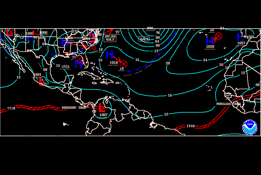
Note Carribean islanders that the CMC sends a system into the NE Leeward islands, although keeps it weak at this point.

Jeff Masters is somewhat bullish on ITCZ development but doesn't mention where:

Well, I'm back to blogging after an enjoyable week off camping and paddling along Lake Huron. It was a good time to be gone--significant landfalling storms in late July and early August are uncommon, and this year was no exception. The quiet conditions look likely to continue this week. There are no threat areas to discuss in the Atlantic, and none of the reliable computer models are forecasting any development over the next seven days. The Intertropical Convergence Zone (ITCZ), the band of active thunderstorms between Africa and the Lesser Antilles Islands that frequently serves as a genesis region for August tropical storms, is relatively quiet right now. However, it would not surprise me to see some activity in the ITCZ late this week. Ocean temperatures continue to warm, headed towards their early September peak. Wind shear and Saharan dry air/dust activity are near normal or below normal between Africa and the Lesser Antilles. The long-range steering current forecast from the GFS model continues to show a near-normal pattern, with the jet stream not forecast to "lock in" to a configuration that will enhance the risk of a hurricane strike to any particular region. But it isn't until around August 18 that hurricane activity historically begins its major activity period, so we may still have another quiet week or two ahead.
0 likes   

User avatar
cycloneye
Admin
Admin
Posts: 145884
Age: 69
Joined: Thu Oct 10, 2002 10:54 am
Location: San Juan, Puerto Rico

Re: Tropical Wave in the Central Atlantic with Cyclonic Spin

#13 Postby cycloneye » Mon Aug 06, 2007 10:29 am

ABNT20 KNHC 061517
TWOAT
TROPICAL WEATHER OUTLOOK
NWS TPC/NATIONAL HURRICANE CENTER MIAMI FL
1130 AM EDT MON AUG 6 2007

FOR THE NORTH ATLANTIC...CARIBBEAN SEA AND THE GULF OF MEXICO...

A SMALL AREA OF LOW PRESSURE AND ASSOCIATED DISTURBED WEATHER IS
LOCATED OVER THE EXTREME SOUTHWESTERN GULF OF MEXICO...JUST TO THE
EAST OF VERACRUZ MEXICO. THIS SYSTEM IS EXPECTED TO MOVE INLAND
LATER TODAY AND SIGNIFICANT DEVELOPMENT IS NOT ANTICIPATED.

ELSEWHERE...TROPICAL CYCLONE FORMATION IS NOT EXPECTED DURING THE
NEXT 48 HOURS.

$$
FORECASTER PASCH


No mention of the wave in Atlantic at the 11:30 AM Tropical Weather Outlook.
0 likes   

User avatar
gatorcane
S2K Supporter
S2K Supporter
Posts: 23692
Age: 47
Joined: Sun Mar 13, 2005 3:54 pm
Location: Boca Raton, FL

#14 Postby gatorcane » Mon Aug 06, 2007 12:57 pm

waiting for the TWD at 2:05, CMC develops this system (and for once its not a phantom system)...
0 likes   

User avatar
cycloneye
Admin
Admin
Posts: 145884
Age: 69
Joined: Thu Oct 10, 2002 10:54 am
Location: San Juan, Puerto Rico

Re: Tropical Wave in the Central Atlantic with Cyclonic Spin

#15 Postby cycloneye » Mon Aug 06, 2007 1:03 pm

HIGH AMPLITUDE TROPICAL WAVE IS ALONG 37W S OF 26N MOVING W NEAR
20 KT. THIS WAVE CONTINUES TO EXHIBIT A LARGE INVERTED V SHAPE
IN THE SURROUNDING STRATOCUMULUS CLOUDS. DEEP CONVECTION REMAINS
LIMITED TO THE SRN PORTION OF THE AXIS WHERE IT INTERSECTS WITH
THE ITCZ...WITH SCATTERED MODERATE FROM 9N-14N BETWEEN 32W-40W.


2 PM Discussion of this wave by TPC.

No turning in this wave as they dont mention anything.
0 likes   

User avatar
skysummit
S2K Supporter
S2K Supporter
Posts: 5305
Age: 49
Joined: Tue Aug 31, 2004 11:09 pm
Location: Ponchatoula, LA
Contact:

#16 Postby skysummit » Mon Aug 06, 2007 1:07 pm

Oh well, I guess my eyes are deceiving me 8-)
0 likes   

User avatar
gatorcane
S2K Supporter
S2K Supporter
Posts: 23692
Age: 47
Joined: Sun Mar 13, 2005 3:54 pm
Location: Boca Raton, FL

Re: Tropical Wave in the Central Atlantic with Cyclonic Spin

#17 Postby gatorcane » Mon Aug 06, 2007 1:09 pm

I believe that TWD is conservative and they want to wait the rest of the day to watch it to see if the apparent "spin" continues. There is no question there is a spin if you look at the visible loops.
0 likes   

User avatar
southerngreen
Tropical Storm
Tropical Storm
Posts: 141
Joined: Mon Jul 04, 2005 2:11 am
Location: Thonotosassa, FL & Old Fort, TN

#18 Postby southerngreen » Mon Aug 06, 2007 1:36 pm

http://www.accuweather.com/hurricane/sa ... n=atlantic

looks impressive here - is it just "window dressing"?
0 likes   

User avatar
CourierPR
Category 5
Category 5
Posts: 1335
Age: 71
Joined: Tue Aug 31, 2004 7:53 pm
Location: Pompano Beach, Florida

Re: Tropical Wave in the Central Atlantic with Cyclonic Spin

#19 Postby CourierPR » Mon Aug 06, 2007 1:45 pm

I think that we should refrain from making assumptions based on what is not said by the NHC in discussions and/or outlooks.
0 likes   

Dean4Storms
S2K Supporter
S2K Supporter
Posts: 6358
Age: 62
Joined: Sun Aug 31, 2003 1:01 pm
Location: Miramar Bch. FL

#20 Postby Dean4Storms » Mon Aug 06, 2007 1:52 pm

I don't see much of a spin. Looks like nothing but a TW.
0 likes   


Return to “Talkin' Tropics”

Who is online

Users browsing this forum: No registered users and 22 guests