Long-Term Model Runs
Moderator: S2k Moderators
Forum rules

The posts in this forum are NOT official forecasts and should not be used as such. They are just the opinion of the poster and may or may not be backed by sound meteorological data. They are NOT endorsed by any professional institution or STORM2K. For official information, please refer to products from the National Hurricane Center and National Weather Service.

Re: All Long-Term Model Runs
I agree EWG. I think that stems from last year's "Houston we have a problem" statement was made regarding TS Chris last year.
0 likes
-
cheezyWXguy

- Category 5

- Posts: 6281
- Joined: Mon Feb 13, 2006 12:29 am
- Location: Dallas, TX
Re: All Long-Term Model Runs
well, Im up to 162hrs at the moment and the GFS brings this storm to 1004 in the central atlantic, which maybe the most bullish it has been so far
0 likes
-
cheezyWXguy
- Category 5
- Posts: 6281
- Joined: Mon Feb 13, 2006 12:29 am
- Location: Dallas, TX
Re: All Long-Term Model Runs
KatDaddy wrote:I agree EWG. I think that stems from last year's "Houston we have a problem" statement was made regarding TS Chris last year.
That wasnt all that far fetched...had Chris maintained strength til the GOM, he probably wouldve gone to the TX coast, based on the position of the ridge in the gulf...but Chris died and nothing happened
0 likes
-
x-y-no

- Category 5
- Posts: 8359
- Age: 65
- Joined: Wed Aug 11, 2004 12:14 pm
- Location: Fort Lauderdale, FL
Re: All Long-Term Model Runs
cheezyWXguy wrote:well, Im up to 162hrs at the moment and the GFS brings this storm to 1004 in the central atlantic, which maybe the most bullish it has been so far
Yep, and depicting a strengthening mid-level ridge over the top.
0 likes
-
jasons2k

- Storm2k Executive

- Posts: 8290
- Age: 52
- Joined: Wed Jul 06, 2005 12:32 pm
- Location: The Woodlands, TX
We're now getting close to mid-August and this is exactly the kind of pattern I have been fearing would develop at the heart of the season.
In all honesty I thought things would have cranked-up by now, but it looks like the wait will be over soon, here is a sampling of a few things:
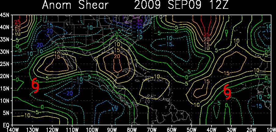
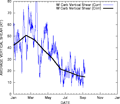
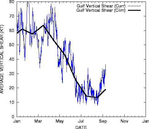
Shear is relaxing. The anomolous shear is really low in the Caribbean:
http://www.ssd.noaa.gov/PS/TROP/DATA/gparm/xyashr.gif
http://www.ssd.noaa.gov/PS/TROP/DATA/gparm/wcashr.gif
http://www.ssd.noaa.gov/PS/TROP/DATA/gparm/gmxshr.gif
SSTs in the GOM have really warmed, the LA/TX coast has caught-up from being cool earlier this summer:
http://fermi.jhuapl.edu/avhrr/gm/averag ... _multi.png
Pretty much above normal everywhere, the WGOM has caught-up:
http://www.osdpd.noaa.gov/PSB/EPS/SST/d ... 6.2007.gif
TCHP is getting crazy in the NW Caribbean:
http://www.aoml.noaa.gov/phod/dataphod1 ... 7219at.jpg
In all honesty I thought things would have cranked-up by now, but it looks like the wait will be over soon, here is a sampling of a few things:
Shear is relaxing. The anomolous shear is really low in the Caribbean:
http://www.ssd.noaa.gov/PS/TROP/DATA/gparm/xyashr.gif
http://www.ssd.noaa.gov/PS/TROP/DATA/gparm/wcashr.gif
http://www.ssd.noaa.gov/PS/TROP/DATA/gparm/gmxshr.gif
SSTs in the GOM have really warmed, the LA/TX coast has caught-up from being cool earlier this summer:
http://fermi.jhuapl.edu/avhrr/gm/averag ... _multi.png
Pretty much above normal everywhere, the WGOM has caught-up:
http://www.osdpd.noaa.gov/PSB/EPS/SST/d ... 6.2007.gif
TCHP is getting crazy in the NW Caribbean:
http://www.aoml.noaa.gov/phod/dataphod1 ... 7219at.jpg
0 likes
-
jasons2k
- Storm2k Executive
- Posts: 8290
- Age: 52
- Joined: Wed Jul 06, 2005 12:32 pm
- Location: The Woodlands, TX
Re: All Long-Term Model Runs
KatDaddy wrote:I agree EWG. I think that stems from last year's "Houston we have a problem" statement was made regarding TS Chris last year.
That and also when it was already obvious Rita was going to turn east, he cried 'Galveston, Galveston, along I-45 up to Conroe' up until the very end.
0 likes
-
Weatherfreak14

- Category 5
- Posts: 1381
- Joined: Sat Sep 24, 2005 3:40 pm
- Location: Beaufort, SC
- Contact:
Re: All Long-Term Model Runs
Wow has anyone notced the 12z run it takes this sytem into the carribean and towards the yuctan. 
0 likes
-
cheezyWXguy
- Category 5
- Posts: 6281
- Joined: Mon Feb 13, 2006 12:29 am
- Location: Dallas, TX
Re: All Long-Term Model Runs
Im not sure the ridge will really be strong enough to push a strong TS or higher south into the carribean, but i guess it wouldnt surprise me if it happened
0 likes
-
southerngale

- Retired Staff

- Posts: 27418
- Joined: Thu Oct 10, 2002 1:27 am
- Location: Southeast Texas (Beaumont area)
Re: All Long-Term Model Runs
jschlitz wrote:KatDaddy wrote:I agree EWG. I think that stems from last year's "Houston we have a problem" statement was made regarding TS Chris last year.
That and also when it was already obvious Rita was going to turn east, he cried 'Galveston, Galveston, along I-45 up to Conroe' up until the very end.
Yeah, but I specifically remember him mentioning Beaumont on TV before we even evacuated, and I evacuated late Wednesday night (it hit overnight Fri./Sat. morn.) while Rita was still forecast by the NHC to hit farther down the coast.
I don't follow JB that much, but he was right about the effects on Southeast Texas... very destructive... worst we've ever seen. But yeah, not right about the Houston/Galveston area. Close, though.
0 likes
-
Blown Away

- S2K Supporter

- Posts: 10253
- Joined: Wed May 26, 2004 6:17 am
Re: All Long-Term Model Runs
Yesterday morning the GFS had the low over SFL, then that afternoon the low was out to sea, now the low is near Yucatan.
Nice!!
Nice!!
0 likes

Re: All Long-Term Model Runs
>>"We're gonna have to see if something comes for the Texas coast, 'cause I think now that is the place to really start watching. ok. It's not because I want to destroy Houston, it's because this is the way the weather pattern is setting up."
Yeah, if the pattern echoes or mimmicks what's happening in Asia, depending on pulses, you'd want to think the Texas and Mexico coasts would be most at risk after a few days then for at least a week or two. Except for Usagi (or whatever its name was), most of the recent stuff out there is weak. Not sure if that's a change in the pattern getting ready to happen over there, a downpulse in activity or if the WPAC is just recharching.
15-20 days from when the SOI went back positive for +/- 9 days would be starting this weekend and lasting a week or so. Would be another indicator of a possibly opened Gulf of Mexico.
http://www.longpaddock.qld.gov.au/Seaso ... SOIValues/
Steve
0 likes
-
ncupsscweather

- Category 1

- Posts: 321
- Age: 38
- Joined: Tue Jan 02, 2007 8:05 pm
- Location: Hickory,North Carolina
Re: All Long-Term Model Runs
Yea I know, But this is still some time out and the GFS isn't good at long range anyways.... CMC was also showing that to yesterday but now it's not showing anything like that except at the end of the run it show's something of the Coast of North Carolina.
0 likes

Re: All Long-Term Model Runs
GFS is building a monster upper level ridge (>594 dm) over the southern plains and southeast on the 12Z GFS run that is shoving the cyclone into the Yucatan. This is the first time I've seen this ridge on a GFS run so we'll just have to see how it evolves. There is a tendency over the last few days to increase the strength of the Atlantic Ridge in both the GFS and ECMWF models after the latest east coast trough pulls out in 7 days.

0 likes
Re: All Long-Term Model Runs
Wow, 12Z CMC goes bananas with explosive GOM development.
http://moe.met.fsu.edu/cgi-bin/cmctc2.cgi?time=2007080812&field=Sea+Level+Pressure&hour=Animation
http://moe.met.fsu.edu/cgi-bin/cmctc2.cgi?time=2007080812&field=Sea+Level+Pressure&hour=Animation
0 likes
-
DESTRUCTION5

- Category 5
- Posts: 4430
- Age: 44
- Joined: Wed Sep 03, 2003 11:25 am
- Location: Stuart, FL
Re: All Long-Term Model Runs
ronjon wrote:Wow, 12Z CMC goes bananas with explosive GOM development.
http://moe.met.fsu.edu/cgi-bin/cmctc2.cgi?time=2007080812&field=Sea+Level+Pressure&hour=Animation
Id call that a major faulty run...
0 likes
-
miamicanes177
- Category 5
- Posts: 1131
- Joined: Tue Aug 01, 2006 10:53 pm
Re: All Long-Term Model Runs
ronjon wrote:Wow, 12Z CMC goes bananas with explosive GOM development.
http://moe.met.fsu.edu/cgi-bin/cmctc2.cgi?time=2007080812&field=Sea+Level+Pressure&hour=Animation
that would be a dream come true

0 likes
Who is online
Users browsing this forum: TeamPlayersBlue, Ulf and 225 guests