Strong Eastern Atlantic Wave (1009mb surface Low)

This is the general tropical discussion area. Anyone can take their shot at predicting a storms path.

Moderator: S2k Moderators

Forum rules

The posts in this forum are NOT official forecasts and should not be used as such. They are just the opinion of the poster and may or may not be backed by sound meteorological data. They are NOT endorsed by any professional institution or STORM2K. For official information, please refer to products from the National Hurricane Center and National Weather Service.

Help Support Storm2K
Message
Author
Aric Dunn
Category 5
Category 5
Posts: 21238
Age: 42
Joined: Sun Sep 19, 2004 9:58 pm
Location: Ready for the Chase.
Contact:

Strong Eastern Atlantic Wave (1009mb surface Low)

#1 Postby Aric Dunn » Mon Aug 13, 2007 4:28 pm

http://www.meteo.psu.edu/~gadomski/SAT_ ... 16vis.html
visible loop
you must omit images 9,10,11,12,14,15,16. otherwise it skips..

but WOW that circulation is well defined and is heading west ... earlier i was not worried about because i thought it was heading north and over cooler waters . but it looks like it caught under the strong ridge and has been heading west now for a while.. its is very possible that we may have another player here soon and convection on the last few images seems to slightly increasing ( a little ).

since its heading over top the Cape verde islands here are the latest obs from the show a possible circ from the winds
http://weather.noaa.gov/weather/current/GVAC.html

its initialized at
1009mb
Image

it maybe our next invest should it decide to gain some convection


sst's appear to be warm enough
Image


Sal
is not bad at all actaully very weak
Image


there appears to be plenty of moisture in the mid levels
so dry air is not really a problem
Image


midlevel Water Vapor
Image


and upper level
vapor
Image


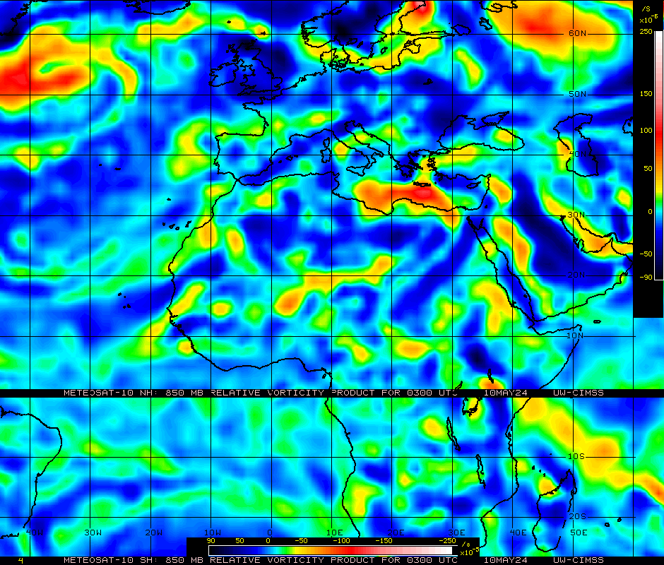
Here is the 850mb vort showing very evident circ at least in the mid levels

Image


And shear is much lighter at that latitude

Image


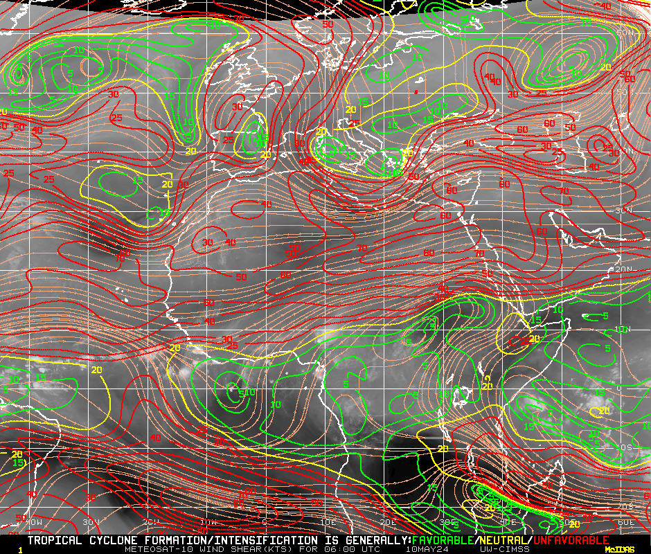
So all in all conditions appear quite favorable for something to possibly come from this over the next couple of day!!!!
Last edited by Aric Dunn on Mon Aug 13, 2007 4:49 pm, edited 1 time in total.
0 likes   

Aric Dunn
Category 5
Category 5
Posts: 21238
Age: 42
Joined: Sun Sep 19, 2004 9:58 pm
Location: Ready for the Chase.
Contact:

#2 Postby Aric Dunn » Mon Aug 13, 2007 4:38 pm

Any questions! lol
0 likes   

txwatcher91
Category 5
Category 5
Posts: 1498
Joined: Tue Aug 02, 2005 2:29 pm

Re: Strong eastern atlantics wave (surface Low)

#3 Postby txwatcher91 » Mon Aug 13, 2007 4:43 pm

This wave should definately be watched because of the well defined circulation. This could definately be a player down the road IMO.
0 likes   

Aric Dunn
Category 5
Category 5
Posts: 21238
Age: 42
Joined: Sun Sep 19, 2004 9:58 pm
Location: Ready for the Chase.
Contact:

Re: Strong eastern atlantics wave (surface Low)

#4 Postby Aric Dunn » Mon Aug 13, 2007 4:46 pm

txwatcher91 wrote:This wave should definitely be watched because of the well defined circulation. This could definitely be a player down the road IMO.


you can also clearly see the low level circ moving west ...
on this loop in the upper right hand corner....... all it needs is convection !!
http://oiswww.eumetsat.org/SDDI/cgi/lis ... 0#controls
0 likes   

txwatcher91
Category 5
Category 5
Posts: 1498
Joined: Tue Aug 02, 2005 2:29 pm

Re: Strong eastern atlantics wave (surface Low)

#5 Postby txwatcher91 » Mon Aug 13, 2007 4:55 pm

Aric Dunn wrote:you can also clearly see the low level circ moving west ...
on this loop in the upper right hand corner....... all it needs is convection !!
http://oiswww.eumetsat.org/SDDI/cgi/lis ... 0#controls


Once it reaches 30W, it will reach some slightly warmer water. This should help it gain convection as it reaches the warmer water, especially once it hits 40W it should begin to get out of the dry air.
Image
0 likes   

User avatar
WindRunner
Category 5
Category 5
Posts: 5806
Age: 34
Joined: Fri Jul 29, 2005 8:07 pm
Location: Warrenton, VA, but Albany, NY for school
Contact:

#6 Postby WindRunner » Mon Aug 13, 2007 5:45 pm

It was interesting to see this wave emerge about 36 hours ago . . . as the swirl moved off the coast, convection fired over the water. QS passes have showed a decent, though elongated, circulation associated with the wave. Other than being pretty far north in latitude, this wave looks pretty good and has the support of several models, including the Euro and CMC. Don't remember if the GFS carried it or not, but I wouldn't be surprised to see it start carrying something through there . . .
0 likes   

CrazyC83
Professional-Met
Professional-Met
Posts: 34006
Joined: Tue Mar 07, 2006 11:57 pm
Location: Deep South, for the first time!

#7 Postby CrazyC83 » Mon Aug 13, 2007 7:05 pm

Will they declare this 92L soon?
0 likes   

User avatar
cycloneye
Admin
Admin
Posts: 145881
Age: 69
Joined: Thu Oct 10, 2002 10:54 am
Location: San Juan, Puerto Rico

Re: Strong Eastern Atlantic Wave (1009mb surface Low)

#8 Postby cycloneye » Mon Aug 13, 2007 7:16 pm

TROPICAL WAVES...
A TROPICAL WAVE WAS ADDED ALONG 19/20W ESTIMATED TO BE MOVING W
NEAR 15 KT. A 1009 MB LOW IS ALONG THE WAVE NEAR 15N...WHICH
SHOWED UP WELL IN A RECENT QUIKSCAT PASS. THE WAVE PASSAGE WAS
VERY EVIDENT IN THE DAKAR SOUNDING DATA FROM LAST NIGHT TO THIS
MORNING. DEEP CONVECTION IS MINIMAL THOUGH THE ASSOCIATED
CLOUDINESS IS BEGINNING TO SPREAD THROUGH THE CAPE VERDE
ISLANDS.


8 PM Discussion of wave/low.
0 likes   

User avatar
HurryKane
Category 5
Category 5
Posts: 1941
Joined: Sun Sep 12, 2004 8:08 pm
Location: Diamondhead, Mississippi

Re: Strong Eastern Atlantic Wave (1009mb surface Low)

#9 Postby HurryKane » Tue Aug 14, 2007 5:36 am

Aric Dunn wrote:
there appears to be plenty of moisture in the mid levels
so dry air is not really a problem
Image


Speaking entirely from an unscientific "Wow that's cool!" perspective....wow, that gif is COOL! Thanks for posting. *bookmarks*
0 likes   

O Town
S2K Supporter
S2K Supporter
Posts: 5205
Age: 52
Joined: Wed Sep 07, 2005 9:37 pm
Location: Orlando, Florida 28°35'35"N 81°22'55"W

Re: Strong Eastern Atlantic Wave (1009mb surface Low)

#10 Postby O Town » Tue Aug 14, 2007 7:50 am

LOL HurryKane, it is a very cool graphic to watch.

This thing looks huge compared with TD4. About halfway emerged.


Image
0 likes   


Return to “Talkin' Tropics”

Who is online

Users browsing this forum: 869MB, Landy, Ulf and 27 guests