
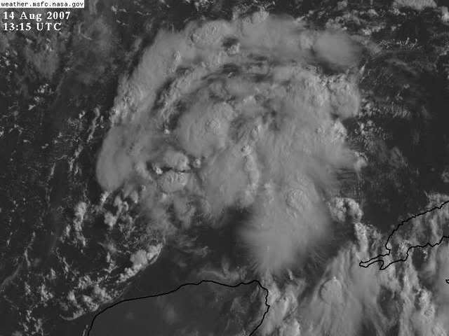
Alright I'll be the first to say it, this mornings LLC looks to be falling apart and we probably will have reformation to the NE nearer the heavier convection.
http://weather.msfc.nasa.gov/GOES/GOES1 ... D9XFbV.jpg
INVEST 91L -Discussions,Analysis and Imagery
Moderator: S2k Moderators
-
Extremeweatherguy

- Category 5

- Posts: 11095
- Joined: Mon Oct 10, 2005 8:13 pm
- Location: Florida
Re: INVEST 91L: in SE GOM,Discussions,Analysis and Sat Pics
It almost looks as if the current LLC is being "pulled" NE into the convection.
0 likes

>>would not be surprised to see a landfalling hurricane out of this since conditions are becoming obscenely favorable
Yeah, people get hung up on the whole shear thing. It's often just part of the process. The reversal of the shear pattern is often indicative of quite the opposite of what some posters think they are seeing (at least the ones who want to be first to ring the death knell).
It will be interesting to see the evolution today and tomorrow of this system. I know some had it progged to be inland tomorrow night. I don't see it. It's gonna be Thursday sometime IMHO.
Steve
0 likes

Re: INVEST 91L: in SE GOM,Discussions,Analysis and Sat Pics
I thought this wave was going to be a depression 3 days ago so I'm already wrong, but I will put in my vote that this thing still makes it to at least minimal hurricane strength before landfall. I just don't see how anyone can say this thing looks that weak. It is finally in the right spot for organization. If you still think it is weak and disorganized at 5 today then maybe it isn't as primed for developing as previously thought. It's the first time we've seen a true wave reach the southern GOM this year. (Well except the skirting of the BOC that 99L did.)
0 likes
-
Stratosphere747
- Category 5
- Posts: 3772
- Joined: Thu Sep 11, 2003 8:34 pm
- Location: Surfside Beach/Freeport Tx
- Contact:
Re: INVEST 91L: in SE GOM,Discussions,Analysis and Sat Pics
I don't know if this is a mistake, but they may have canceled recon for today. A bit surprising if true.
TROPICAL WEATHER DISCUSSION
NWS TPC/NATIONAL HURRICANE CENTER MIAMI FL
805 AM EDT TUE AUG 14 2007
A 1007 MB LOW IS CENTERED NEAR 22N88W...OR JUST OFF THE N COAST
OF THE YUCATAN PENINSULA. THE ASSOCIATED TROPICAL WAVE IS JUST
OT THE W OF THE LOW CENTER. THE SYSTEM CONTINUES INTERACT WITH
AN UPPER LOW MOVING ACROSS THE W GULF OF MEXICO AND IS PRODUCING
WIDESPREAD CLOUDINESS WITH CLUSTERS OF SCATTERED
SHOWERS/ISOLATED THUNDERSTORMS OVER THE SE GULF...S OF 27N
BETWEEN 83W-90W. UPPER-LEVEL WINDS CONTINUE TO BECOME MORE
FAVORABLE FOR DEVELOPMENT OF THIS SYSTEM...AND A TROPICAL
DEPRESSION COULD FORM LATER TODAY AS THE LOW MOVES TO THE WNW
NEAR 10-15 KT. INTERESTS IN THE W GULF OF MEXICO SHOULD CONTINUE
TO MONITOR THE PROGRESS OF THIS SYSTEM. AN AIR FORCE RESERVE
RECONNAISSANCE PLANE IS SCHEDULED TO INVESTIGATE THIS SYSTEM
TOMORROW AFTERNOON...IF NECESSARY
0 likes


-
Extremeweatherguy
- Category 5
- Posts: 11095
- Joined: Mon Oct 10, 2005 8:13 pm
- Location: Florida
-
lrak

- S2K Supporter

- Posts: 1770
- Age: 59
- Joined: Thu Jun 21, 2007 2:48 pm
- Location: Corpus Christi, TX
Re: INVEST 91L: in SE GOM,Discussions,Analysis and Sat Pics
I thought they would already be in the air.
0 likes

Re: INVEST 91L: in SE GOM,Discussions,Analysis and Sat Pics
lrak wrote:I thought they would already be in the air.
Plane leaves at 1700Z, which is 1 pm EDT.
0 likes
-
Stratosphere747
- Category 5
- Posts: 3772
- Joined: Thu Sep 11, 2003 8:34 pm
- Location: Surfside Beach/Freeport Tx
- Contact:
Re: INVEST 91L: in SE GOM,Discussions,Analysis and Sat Pics
Chacor wrote:lrak wrote:I thought they would already be in the air.
Plane leaves at 1700Z, which is 1 pm EDT.
Had me scratching my head. TWD must be a typo. Figured they would have corrected something like that.
0 likes
-
lrak
- S2K Supporter
- Posts: 1770
- Age: 59
- Joined: Thu Jun 21, 2007 2:48 pm
- Location: Corpus Christi, TX
Re: INVEST 91L: in SE GOM,Discussions,Analysis and Sat Pics
Chacor wrote:lrak wrote:I thought they would already be in the air.
Plane leaves at 1700Z, which is 1 pm EDT.
Whoops misread post
0 likes
-
lrak
- S2K Supporter
- Posts: 1770
- Age: 59
- Joined: Thu Jun 21, 2007 2:48 pm
- Location: Corpus Christi, TX
Re: INVEST 91L: in SE GOM,Discussions,Analysis and Sat Pics
This will be fun to watch all day. Boss (Partner) came in and said what you have going today, and I turned the monitor around, "Oh" he said
0 likes
-
Extremeweatherguy
- Category 5
- Posts: 11095
- Joined: Mon Oct 10, 2005 8:13 pm
- Location: Florida

Re: INVEST 91L: in SE GOM,Discussions,Analysis and Sat Pics
The LLC is getting sheared and elongated toward the northeast. Later this afternoon when recon gets out there we should get a better idea of what is going on. Barry chased its convection north but he was much better stacked than what 91L looks like this morning..
0 likes


-
Stratosphere747
- Category 5
- Posts: 3772
- Joined: Thu Sep 11, 2003 8:34 pm
- Location: Surfside Beach/Freeport Tx
- Contact:
Re:
Derek Ortt wrote:AF is very short handed with 4 planes in Hawaii
So there is a possibility of no recon today?
0 likes
-
HouTXmetro

- Category 5
- Posts: 3949
- Joined: Sun Jun 13, 2004 6:00 pm
- Location: District of Columbia, USA
Re: INVEST 91L: in SE GOM,Discussions,Analysis and Sat Pics
In that loop the LLC is moving NW.
0 likes
Who is online
Users browsing this forum: No registered users and 18 guests