INVEST 91L -Discussions,Analysis and Imagery

Moderator: S2k Moderators

Message
Author
Air Force Met
Military Met
Military Met
Posts: 4372
Age: 56
Joined: Tue Jul 08, 2003 9:30 am
Location: Roan Mountain, TN

Re: Re:

#481 Postby Air Force Met » Tue Aug 14, 2007 10:03 am

tailgater wrote:
Derek Ortt wrote:very well-defined LLC now just SW of the convection

I doubt that this reforms to the NE now


Derek do still think relocation is doubtful, the area @ 23N 87W continues to refire? Just a question don't read anything into it.


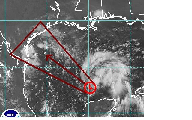
I am not sure a relocation is the right term here. I do, however, think this system is ripe to pull the center towards the convection. It has the look: A weak LLC with light southerly shear over the center and all of the convection to the North and east. The LLC is also elongated. It looks to me like it could easily get pulled Northward towards the convection near 25N...even before it crosses 91 or 92W. Like I said last night...I think it will mimic what Claudette did in terms of the center moving northward towards the convection...it just won't do it as much because it is moving a bit faster.
0 likes   

User avatar
Portastorm
Storm2k Moderator
Storm2k Moderator
Posts: 9914
Age: 62
Joined: Fri Jul 11, 2003 9:16 am
Location: Round Rock, TX
Contact:

Re: INVEST 91L: in SE GOM,Discussions,Analysis and Sat Pics

#482 Postby Portastorm » Tue Aug 14, 2007 10:06 am

Given the obvious development of 91L in the last 12 hours, I'm really surprised that NHC has not even named it a TD yet. You would think they'd error on the side of caution considering its proximity to offshore oil interests as well as population centers along the Gulf.

I've seen them tag a system looking a lot worse than this ...
0 likes   

User avatar
Extremeweatherguy
Category 5
Category 5
Posts: 11095
Joined: Mon Oct 10, 2005 8:13 pm
Location: Florida

#483 Postby Extremeweatherguy » Tue Aug 14, 2007 10:06 am

000
ABNT20 KNHC 141505
TWOAT
TROPICAL WEATHER OUTLOOK
NWS TPC/NATIONAL HURRICANE CENTER MIAMI FL
1130 AM EDT MON AUG 14 2007

FOR THE NORTH ATLANTIC...CARIBBEAN SEA AND THE GULF OF MEXICO...

THE NATIONAL HURRICANE CENTER IS ISSUING ADVISORIES ON RECENTLY
UPGRADED TROPICAL STORM DEAN...LOCATED ABOUT 1490 MILES EAST OF THE
LESSER ANTILLES.

SATELLITE IMAGES AND SURFACE DATA INDICATE THAT THE AREA OF LOW
PRESSURE IN THE SOUTH CENTRAL GULF OF MEXICO IS GRADUALLY BECOMING
BETTER ORGANIZED AND A TROPICAL DEPRESSION COULD BE FORMING. A
RECONNAISSANCE AIRCRAFT IS SCHEDULED TO CHECK THE AREA THIS
AFTERNOON. THIS SYSTEM IS EXPECTED TO MOVE TOWARD THE
WEST-NORTHWEST OR NORTHWEST AT 10 TO 15 MPH. ALL INTERESTS IN THE
NORTHWESTERN GULF OF MEXICO...INCLUDING THE SOUTHERN TEXAS AND
NORTHEASTERN MEXICO COASTAL AREAS...SHOULD CLOSELY MONITOR THE
PROGRESS OF THIS SYSTEM...AND BE READY TO TAKE ACTIONS. TROPICAL
STORM WATCHES OR WARNINGS COULD BE PROMPTLY REQUIRED FOR A PORTION
OF THE COAST.


ELSEWHERE...TROPICAL CYCLONE FORMATION IS NOT EXPECTED DURING THE
NEXT 48 HOURS.
0 likes   

Derek Ortt

#484 Postby Derek Ortt » Tue Aug 14, 2007 10:09 am

I am not so sure this won't end up intensifying faster than Caludette did. Claudette was only under low shear for about 12 hours and it was about to undergo RI.

This seems to me to be like Charley 1998 which went from a TD to a enar cane in less than 24 hours... and this may have about 36-42 more hours over the water
0 likes   

User avatar
HURAKAN
Professional-Met
Professional-Met
Posts: 46086
Age: 38
Joined: Thu May 20, 2004 4:34 pm
Location: Key West, FL
Contact:

#485 Postby HURAKAN » Tue Aug 14, 2007 10:09 am

WEATHER RECONNAISSANCE FLIGHTS
CARCAH, NATIONAL HURRICANE CENTER, MIAMI, FL.
0930 AM EDT TUE 14 AUGUST 2007
SUBJECT: TROPICAL CYCLONE PLAN OF THE DAY (TCPOD)
VALID 15/1100Z TO 16/1100Z AUGUST 2007
TCPOD NUMBER.....07-083

I. ATLANTIC REQUIREMENTS
1. SUSPECT AREA (GULF OF MEXICO)
FLIGHT ONE
A. 15/1200,1500Z
B. NOAA2X 02EEA CYCLONE
C. 15/0930Z
D. 24.9N 94.9W
E. 15/1100Z TO 15/1530Z
F. SFC TO 10,000 FT
G. REMARKS: ORIGINALLY AN AF MISSION FOR 15/0900Z.

FLIGHT TWO
A. 15/1800,16/0000Z
B. AFXXX 03EEA CYCLONE
C. 15/1530Z
D. 25.5N 95.6W
E. 15/1700Z TO 16/0000Z
F. SFC TO 10,000 FT
2. SUCCEEDING DAY OUTLOOK: NEGATIVE IN THE GULF OF MEXICO,
BUT BEGIN FIXING TD 04 AT 16/1800Z NEAR 13.5N 53.5W
0 likes   

miamicanes177
Category 5
Category 5
Posts: 1131
Joined: Tue Aug 01, 2006 10:53 pm

Re: INVEST 91L - 11:30 TWO "A TD could be forming"

#486 Postby miamicanes177 » Tue Aug 14, 2007 10:12 am

And Derek remember Wilma 2005 went from tropical storm to cat 5 in 1 day. That was a rare event though but just goes to show anything can happen. Texas folks need to be paying attention to this one.
0 likes   

Brent
S2K Supporter
S2K Supporter
Posts: 37991
Age: 36
Joined: Sun May 16, 2004 10:30 pm
Location: Tulsa Oklahoma
Contact:

Re: INVEST 91L - 11:30 TWO "A TD could be forming"

#487 Postby Brent » Tue Aug 14, 2007 10:13 am

Erin???

And I thought 8 hours ago this thing looked dead. :roll:
0 likes   

User avatar
Extremeweatherguy
Category 5
Category 5
Posts: 11095
Joined: Mon Oct 10, 2005 8:13 pm
Location: Florida

#488 Postby Extremeweatherguy » Tue Aug 14, 2007 10:13 am

Based on the general direction this has been moving, I think that this is probably the most likely track for this system ATM...

Image

...anyone else agree?

The last run of models seemed to be a bit too far south to me. I just do not see this hitting Mexico with it's current WNW to NW motion...especially if the center relocates further NE (which I believe is currently happening).
Last edited by Extremeweatherguy on Tue Aug 14, 2007 10:14 am, edited 1 time in total.
0 likes   

User avatar
HouTXmetro
Category 5
Category 5
Posts: 3949
Joined: Sun Jun 13, 2004 6:00 pm
Location: District of Columbia, USA

Re: INVEST 91L - 11:30 TWO "A TD could be forming"

#489 Postby HouTXmetro » Tue Aug 14, 2007 10:14 am

Convection starting to intensify.

http://www.ssd.noaa.gov/goes/flt/t2/loop-avn.html
0 likes   

User avatar
gatorcane
S2K Supporter
S2K Supporter
Posts: 23689
Age: 47
Joined: Sun Mar 13, 2005 3:54 pm
Location: Boca Raton, FL

Re: INVEST 91L - 11:30 TWO "A TD could be forming"

#490 Postby gatorcane » Tue Aug 14, 2007 10:15 am

Extremeweather guy -- you may finally see something over in Texas......I don't expect it to be more than some T.S winds and rain...but you never know..
0 likes   

User avatar
HURAKAN
Professional-Met
Professional-Met
Posts: 46086
Age: 38
Joined: Thu May 20, 2004 4:34 pm
Location: Key West, FL
Contact:

Re: INVEST 91L - 11:30 TWO "A TD could be forming"

#491 Postby HURAKAN » Tue Aug 14, 2007 10:15 am

Brent wrote:Erin???

And I thought 8 hours ago this thing looked dead. :roll:


Always wait for DMAX to occur before making a call like that!!! That's what I have learned!!
0 likes   

User avatar
Evil Jeremy
S2K Supporter
S2K Supporter
Posts: 5463
Age: 31
Joined: Mon Apr 10, 2006 2:10 pm
Location: Los Angeles, CA

Re: INVEST 91L - 11:30 TWO "A TD could be forming"

#492 Postby Evil Jeremy » Tue Aug 14, 2007 10:16 am

TD at 5 probably,
0 likes   

User avatar
Steve
S2K Supporter
S2K Supporter
Posts: 9591
Joined: Sat Apr 05, 2003 11:41 pm
Location: Not a state-caster

#493 Postby Steve » Tue Aug 14, 2007 10:17 am

>>And I thought 8 hours ago this thing looked dead.

You are one of the posters who is often guilty of posting in absolute terms. And you know that the tropical world is full of surprises. Nothing wrong with being definitive about systems except that they're usually going to prove you wrong when you try to pigeonhole them or declare their fate.

JMO

Steve
0 likes   

RL3AO
Moderator-Pro Met
Moderator-Pro Met
Posts: 16308
Joined: Thu Jun 14, 2007 10:03 pm
Location: NC

#494 Postby RL3AO » Tue Aug 14, 2007 10:17 am

CODE RED

Image
0 likes   

cyclonic chronic

#495 Postby cyclonic chronic » Tue Aug 14, 2007 10:18 am

based on vis sat, seems like there is a nice anti-cyclone over the system
0 likes   

User avatar
skysummit
S2K Supporter
S2K Supporter
Posts: 5305
Age: 49
Joined: Tue Aug 31, 2004 11:09 pm
Location: Ponchatoula, LA
Contact:

Re: INVEST 91L - 11:30 TWO "A TD could be forming"

#496 Postby skysummit » Tue Aug 14, 2007 10:19 am

I would not be surprised for this to be a minimal hurricane at landfall. Things are improving pretty quickly right now.
0 likes   

User avatar
Extremeweatherguy
Category 5
Category 5
Posts: 11095
Joined: Mon Oct 10, 2005 8:13 pm
Location: Florida

#497 Postby Extremeweatherguy » Tue Aug 14, 2007 10:22 am

the center looks to have definitely shifted NE now..

http://adds.aviationweather.gov/satelli ... &itype=vis

The cloud movements now seem to indicate that it is possibly near or under that new burst of convection on the SW side of the system.
0 likes   

cyclonic chronic

Re: INVEST 91L - 11:30 TWO "A TD could be forming"

#498 Postby cyclonic chronic » Tue Aug 14, 2007 10:22 am

skysummit wrote:I would not be surprised for this to be a minimal hurricane at landfall. Things are improving pretty quickly right now.


id have to say that the enviornment aloft and sst's could support moderate intensification, IF there is really a closed low at the surface
0 likes   

User avatar
Hyperstorm
Category 5
Category 5
Posts: 1500
Joined: Sun Sep 07, 2003 3:48 am
Location: Ocala, FL

Re: INVEST 91L - 11:30 TWO "A TD could be forming"

#499 Postby Hyperstorm » Tue Aug 14, 2007 10:24 am

Folks, this system could be a VERY rapid developer. I agree with Derek that this system reminds me of the beginnings of Charley in 1998. The pattern is also quite similar as an upper-low is retrograding westward leaving an environment that is VERY favorable for intensification. With some of the warmest SSTs in the basin and a ridiculously favorable environment setting up, this system can explode into something dangerous. The only limiting thing right now is TIME, but there is plenty of room to strengthen. I just hope we don't see an Alice situation setting up with what looks like the MLC becoming the dominant feature.

Folks south of Corpus Christi in Texas don't have much time waste and NEED to begin preparations TODAY. If the NHC forecasts a category 1 at landfall, prepare for a category higher. You don't want to be caught off guard...
0 likes   

User avatar
Steve
S2K Supporter
S2K Supporter
Posts: 9591
Joined: Sat Apr 05, 2003 11:41 pm
Location: Not a state-caster

#500 Postby Steve » Tue Aug 14, 2007 10:25 am

Time for a new thread IMHO.

Steve
0 likes   


Return to “2007”

Who is online

Users browsing this forum: No registered users and 28 guests