INVEST 91L -Discussions,Analysis and Imagery
Moderator: S2k Moderators
-
HouTXmetro

- Category 5

- Posts: 3949
- Joined: Sun Jun 13, 2004 6:00 pm
- Location: District of Columbia, USA
Re: INVEST 91L - 11:30 TWO "A TD could be forming"
Under the new rules doesn't the thread stay open until the system is upgraded?
0 likes
-
Extremeweatherguy

- Category 5
- Posts: 11095
- Joined: Mon Oct 10, 2005 8:13 pm
- Location: Florida
Re: INVEST 91L - 11:30 TWO "A TD could be forming"
Hyperstorm wrote:Folks, this system could be a VERY rapid developer. I agree with Derek that this system reminds me of the beginnings of Charley in 1998. The pattern is also quite similar as an upper-low is retrograding westward leaving an environment that is VERY favorable for intensification. With some of the warmest SSTs in the basin and a ridiculously favorable environment setting up, this system can explode into something dangerous. The only limiting thing right now is TIME, but there is plenty of room to strengthen. I just hope we don't see an Alice situation setting up with what looks like the MLC becoming the dominant feature.
Folks south of Corpus Christi in Texas don't have much time waste and NEED to begin preparations TODAY. If the NHC forecasts a category 1 at landfall, prepare for a category higher. You don't want to be caught off guard...
I would say not just Corpus southward, I would say anyone south of Galveston Bay needs to be prepared. If this moves ashore where I think it will..between Corpus and Matagorda Bay (based on movement trends), and does become a hurricane, then the outer bands and squalls of this storm could still be fierce well up the coast.
0 likes


-
Tenspeed

- S2K Supporter

- Posts: 24
- Age: 64
- Joined: Tue Sep 09, 2003 9:54 pm
- Location: Lafayette, LA
- Contact:
Re: INVEST 91L - 11:30 TWO "A TD could be forming"
People in Texas better get ready. Not too much talk about this one. People will be taken by surprise.
0 likes
Re: INVEST 91L - 11:30 TWO "A TD could be forming"
Too much talk about center relocation. This is the same center it always was. Today's location shows it was near the coast last night where we were saying it was.
The center is the center of that swirl at low level around 22.6N-90W
Tracking NW now. Still sheared off to the NE by the flow around the ULL.
The center is the center of that swirl at low level around 22.6N-90W
Tracking NW now. Still sheared off to the NE by the flow around the ULL.
0 likes

-
Extremeweatherguy
- Category 5
- Posts: 11095
- Joined: Mon Oct 10, 2005 8:13 pm
- Location: Florida
Re: INVEST 91L - 11:30 TWO "A TD could be forming"
I don't think it has relocated or reformed, but based on satellite cloud movement I do think it may have shifted slightly NE..closer to the deeper convection.Sanibel wrote:Too much talk about center relocation. This is the same center it always was. Today's location shows it was near the coast last night where we were saying it was.
The center is the center of that swirl at low level around 22.6N-90W
Tracking NW now. Still sheared off to the NE by the flow around the ULL.
0 likes

-
HouTXmetro
- Category 5
- Posts: 3949
- Joined: Sun Jun 13, 2004 6:00 pm
- Location: District of Columbia, USA
Re: INVEST 91L - 11:30 TWO "A TD could be forming"
Sanibel wrote:Too much talk about center relocation. This is the same center it always was. Today's location shows it was near the coast last night where we were saying it was.
The center is the center of that swirl at low level around 22.6N-90W
Tracking NW now. Still sheared off to the NE by the flow around the ULL.
The Center is elongated according to some pro-mets..
0 likes
Re: INVEST 91L - 11:30 TWO "A TD could be forming"
My instinct says no rapid development, but if it does (and it is possible over these SST's) you'll see the convection tightly wrap around the exposed spiral quickly.
0 likes
-
Aric Dunn
- Category 5
- Posts: 21238
- Age: 43
- Joined: Sun Sep 19, 2004 9:58 pm
- Location: Ready for the Chase.
- Contact:
Re: INVEST 91L - 11:30 TWO "A TD could be forming"
Sanibel wrote:Too much talk about center relocation. This is the same center it always was. Today's location shows it was near the coast last night where we were saying it was.
The center is the center of that swirl at low level around 22.6N-90W
Tracking NW now. Still sheared off to the NE by the flow around the ULL.
yeah it appears to be the same one from last night as well sanibel ..
it looks much better .. no more shear convection a little more concentrated .. should be a TD soon
the only thing now is that its moving faster so not much time to intensify
but could still make it to minumal hurricane if it gets its act together soon
0 likes
-
Air Force Met
- Military Met

- Posts: 4372
- Age: 56
- Joined: Tue Jul 08, 2003 9:30 am
- Location: Roan Mountain, TN
Re: INVEST 91L - 11:30 TWO "A TD could be forming"
cyclonic chronic wrote:skysummit wrote:I would not be surprised for this to be a minimal hurricane at landfall. Things are improving pretty quickly right now.
id have to say that the enviornment aloft and sst's could support moderate intensification, IF there is really a closed low at the surface
There is no "IF." It's closed. The low clouds on the south side are moving eastward. Those probably have a base no higher than 1500-2000 feet. It would be highly unusual to have a closed circulation at that level and it not reach down to the surface.
Hi-Res loop
0 likes
-
MiamiensisWx
Re: INVEST 91L - 11:30 TWO "A TD could be forming"
Personally, I agree - I think an ideal upper-air environment is developing over 91L. The intensity could depend on the westward retrogression (pace) of the upper low; when the low-level circulation reforms under the main convective mass (could enhance the "engine" for intensification); and the rate of consolidation (LLC beneath MLC). Currently, I think (personal observation) the low-level circulation near 22.7N and 90W is weakening, and a new LLC is consolidating beneath the convection. If it tightens up, that could signal quick development, especially because of the improving mid to upper diffluence and good sfc convergence. I think we'll eventually get Erin, IMO.
http://www.ssd.noaa.gov/goes/flt/t2/loop-vis.html
http://www.ssd.noaa.gov/goes/east/tatl/loop-vis.html
Note the distinct weak anticyclone building over 91L. Additionally, steering currents indicate a possible threat to Texas. I think the exact path depends on the deepening rate, structure, and consolidation of 91L's circulation. The upper low could briefly force a NW movement, but that trend depends on the filling rate (weakening stage) of the low (and whether we see a defined sfc low beneath 91L). These factors could mitigate the pace of development, so the main intensification could occur shortly prior to a possible landfall, IMO - they could "make or break" a TS or hurricane. I would closely watch this system if I resided in TX or Mexico.
0 likes
-
Extremeweatherguy
- Category 5
- Posts: 11095
- Joined: Mon Oct 10, 2005 8:13 pm
- Location: Florida
Based on the Satellite loop, I would currently place the center in this position:
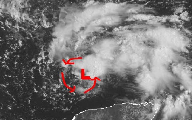
http://adds.aviationweather.gov/satelli ... &itype=vis
Does that look about right?
http://adds.aviationweather.gov/satelli ... &itype=vis
Does that look about right?
0 likes
-
Aric Dunn
- Category 5
- Posts: 21238
- Age: 43
- Joined: Sun Sep 19, 2004 9:58 pm
- Location: Ready for the Chase.
- Contact:
Re:
Extremeweatherguy wrote:Based on the Satellite loop, I would currently place the center in this position:
http://adds.aviationweather.gov/satelli ... &itype=vis
Does that look about right?
looks about right too me
0 likes
Re: INVEST 91L - 11:30 TWO "A TD could be forming"
Air Force Met wrote:cyclonic chronic wrote:skysummit wrote:I would not be surprised for this to be a minimal hurricane at landfall. Things are improving pretty quickly right now.
id have to say that the enviornment aloft and sst's could support moderate intensification, IF there is really a closed low at the surface
There is no "IF." It's closed. The low clouds on the south side are moving eastward. Those probably have a base no higher than 1500-2000 feet. It would be highly unusual to have a closed circulation at that level and it not reach down to the surface.
Hi-Res loop
Thunderstorms are really building on the NE side of the low.
0 likes
-
Air Force Met
- Military Met
- Posts: 4372
- Age: 56
- Joined: Tue Jul 08, 2003 9:30 am
- Location: Roan Mountain, TN
Re: INVEST 91L - 11:30 TWO "A TD could be forming"
HouTXmetro wrote:Sanibel wrote:Too much talk about center relocation. This is the same center it always was. Today's location shows it was near the coast last night where we were saying it was.
The center is the center of that swirl at low level around 22.6N-90W
Tracking NW now. Still sheared off to the NE by the flow around the ULL.
The Center is elongated according to some pro-mets..
It is elongated...NNE-SSW. In these situations the center doesn't "relocate," it gets "dragged." It happens most of the time in an elongated center and the center gets pulled northward towards the convection because that is where the dynamics are occurring and the pressures are lowering. Some call it a relocation...some call it repositioning closer to the convection. Its semantics.
If you look at the hi-res loop I posted...you can see it starting to happen.
0 likes
-
Aric Dunn
- Category 5
- Posts: 21238
- Age: 43
- Joined: Sun Sep 19, 2004 9:58 pm
- Location: Ready for the Chase.
- Contact:
Re: INVEST 91L - 11:30 TWO "A TD could be forming"
Air Force Met wrote:HouTXmetro wrote:Sanibel wrote:Too much talk about center relocation. This is the same center it always was. Today's location shows it was near the coast last night where we were saying it was.
The center is the center of that swirl at low level around 22.6N-90W
Tracking NW now. Still sheared off to the NE by the flow around the ULL.
The Center is elongated according to some pro-mets..
It is elongated...NNE-SSW. In these situations the center doesn't "relocate," it gets "dragged." It happens most of the time in an elongated center and the center gets pulled northward towards the convection because that is where the dynamics are occurring and the pressures are lowering. Some call it a relocation...so call it repositioning closer to the convection. Its semantics.
If you look at the hi-res loop I posted...you can see it starting to happen.
thats exactly right.. did not think about that one
if it can "relocate" fast enough and the center become more defined intensification is fair game .. as the out is great
0 likes
Who is online
Users browsing this forum: No registered users and 72 guests