Yeah, and it looks like that process is already beginning. Should be interesting to see what the NHC decides to do with this.vaffie wrote:It appears that the lowest pressure has been found at 23.3, 90.15W at 1006.8 mb. At that point, the wind changes direction as the plane passed through it, from south to north. I expect this is the new center location that they've identified. It is approximately 90 miles south-south-west of the strongest convection, and so we may find center reforming substantially to the north over the next 12 hours.
INVEST 91L -Discussions,Analysis and Imagery
Moderator: S2k Moderators
-
Extremeweatherguy

- Category 5

- Posts: 11095
- Joined: Mon Oct 10, 2005 8:13 pm
- Location: Florida
Re: INVEST 91L - Discussions,Analysis and Sat Pics
0 likes

Re: INVEST 91L - Discussions,Analysis and Sat Pics
O Town wrote:RL3AO wrote:HouTXmetro wrote:When is the dirunial minimum?
Sunset.
I thought minimum was during the day and maximum is during the night.
It is. Minimum in late afternoon and maximium before sunrise.
0 likes
-
Stormcenter
- S2K Supporter

- Posts: 6689
- Joined: Wed Sep 03, 2003 11:27 am
- Location: Houston, TX
Re: INVEST 91L - Discussions,Analysis and Sat Pics
HouTXmetro wrote:vaffie wrote:It appears that the lowest pressure has been found at 23.3, 90.15W at 1006.8 mb. At that point, the wind changes direction as the plane passed through it, from south to north. I expect this is the new center location that they've identified. It is approximately 90 miles south-south-west of the strongest convection, and so we may find center reforming substantially to the north over the next 12 hours.
It's running out of time, we are going to have landfall by the time this things gets it's stacking issues together... lol
It's all for better if that is the case. We don't need even a minimal hurricane anywhere.
0 likes
-
Stratosphere747
- Category 5
- Posts: 3772
- Joined: Thu Sep 11, 2003 8:34 pm
- Location: Surfside Beach/Freeport Tx
- Contact:
Re: INVEST 91L - Discussions,Analysis and Sat Pics
vaffie wrote:jwayne wrote:18z nam has hurricane hitting matagorda bay Thursday before noon. Can anyone tell how strong?
Link please.
18z

0 likes
-
Extremeweatherguy
- Category 5
- Posts: 11095
- Joined: Mon Oct 10, 2005 8:13 pm
- Location: Florida
The thing that is tricky about these systems is that they can have their highest winds in a very small area. If the recon misses that area, then we may never really know how strong it is. That is why I am dying to see what they can find to the NE of the center in that intensifying blob. If they could find some 25-30 knot winds up there, then I am pretty sure the NHC would go ahead with an upgrade.
0 likes
-
Stormcenter
- S2K Supporter
- Posts: 6689
- Joined: Wed Sep 03, 2003 11:27 am
- Location: Houston, TX
-
Extremeweatherguy
- Category 5
- Posts: 11095
- Joined: Mon Oct 10, 2005 8:13 pm
- Location: Florida


Re: INVEST 91L - Discussions,Analysis and Sat Pics
Thanks. As best as I can make out by zooming in, the 18Z Nam has it make landfall at 42 hours (Thursday 7 am) about 30 miles southwest of Matagorda Bay with a pressure of about 984 mb--which might equate to 70 knots/80 mph. But the 00Z NAM will be much more informative and representative.
0 likes
Re: INVEST 91L - Discussions,Analysis and Sat Pics
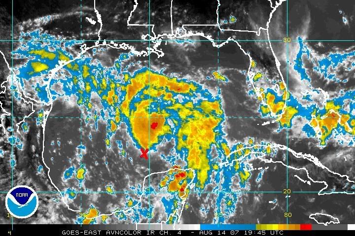
Convection in the last half an hour really booming now to the northeast of the center. I expect that a midlevel center is forming there now and in time the lowest surface pressures will end up there too.
http://weather.msfc.nasa.gov/GOES/goeseastconusir.html
http://weather.msfc.nasa.gov/GOES/goeseastconusir.html
Last edited by vaffie on Tue Aug 14, 2007 4:03 pm, edited 1 time in total.
0 likes
-
KFDM Meteorologist

- Professional-Met

- Posts: 1314
- Joined: Tue May 16, 2006 9:52 pm
- Location: Upper Texas Coast/Orange County
-
marcane_1973

- Category 1

- Posts: 330
- Age: 52
- Joined: Mon Jun 26, 2006 11:01 pm
- Location: N.C.
- Contact:
Re: INVEST 91L - Discussions,Analysis and Sat Pics
marcane_1973 wrote:Recon still flying around this invest?
Flying north now...not sure if they are going home or going to the bigger convection.
0 likes
-
Aric Dunn
- Category 5
- Posts: 21238
- Age: 43
- Joined: Sun Sep 19, 2004 9:58 pm
- Location: Ready for the Chase.
- Contact:
Re: INVEST 91L - Discussions,Analysis and Sat Pics
marcane_1973 wrote:Recon still flying around this invest?
yeah but are not finding much...
they did find west winds.. thats about it
0 likes
-
cycloneye

- Admin

- Posts: 149276
- Age: 69
- Joined: Thu Oct 10, 2002 10:54 am
- Location: San Juan, Puerto Rico
Re: INVEST 91L - Discussions,Analysis and Sat Pics
ABNT20 KNHC 142112
TWOAT
TROPICAL WEATHER OUTLOOK
NWS TPC/NATIONAL HURRICANE CENTER MIAMI FL
530 PM EDT TUE AUG 14 2007
FOR THE NORTH ATLANTIC...CARIBBEAN SEA AND THE GULF OF MEXICO...
THE NATIONAL HURRICANE CENTER IS ISSUING ADVISORIES ON TROPICAL
STORM DEAN...LOCATED ABOUT 1390 MILES EAST OF THE LESSER ANTILLES.
AN AIR FORCE RESERVE UNIT RECONNAISSANCE AIRCRAFT HAS BEEN
INVESTIGATING THE AREA OF LOW PRESSURE IN THE SOUTH CENTRAL GULF OF
MEXICO THIS AFTERNOON. DATA FROM THE RECONNAISSANCE AIRCRAFT
INDICATE THAT THE SYSTEM DOES NOT YET HAVE A WELL-DEFINED
CIRCULATION CENTER...AND THEREFORE IS NOT YET A TROPICAL CYCLONE.
HOWEVER...UPPER-LEVEL WINDS CONTINUE TO BECOME MORE FAVORABLE FOR
DEVELOPMENT AND A TROPICAL DEPRESSION COULD FORM AT ANY TIME
TONIGHT OR TOMORROW AS THE LOW MOVES TO THE WEST-NORTHWEST OR
NORTHWEST AT 10 TO 15 MPH. AIRCRAFT DATA INDICATE THAT MAXIMUM
WINDS WITH THE LOW ARE CURRENTLY AROUND 25 MPH. ALL INTERESTS IN
THE NORTHWESTERN GULF OF MEXICO...INCLUDING THE COASTAL AREAS OF
TEXAS AND NORTHEASTERN MEXICO...SHOULD CLOSELY MONITOR THE PROGRESS
OF THIS SYSTEM...AS TROPICAL STORM WARNINGS WOULD LIKELY BE
REQUIRED IMMEDIATELY UPON THE INITIATION OF ADVISORIES.
ELSEWHERE...TROPICAL CYCLONE FORMATION IS NOT EXPECTED DURING THE
NEXT 48 HOURS.
$$
FORECASTER FRANKLIN
0 likes
-
Ed Mahmoud
Re: INVEST 91L - 5:30 PM Tropical Weather Outlook Posted
21 knot wnd at flight level on last data message.
0 likes
-
Stormcenter
- S2K Supporter
- Posts: 6689
- Joined: Wed Sep 03, 2003 11:27 am
- Location: Houston, TX
Re: INVEST 91L - Discussions,Analysis and Sat Pics
cycloneye wrote:ABNT20 KNHC 142112
TWOAT
TROPICAL WEATHER OUTLOOK
NWS TPC/NATIONAL HURRICANE CENTER MIAMI FL
530 PM EDT TUE AUG 14 2007
FOR THE NORTH ATLANTIC...CARIBBEAN SEA AND THE GULF OF MEXICO...
THE NATIONAL HURRICANE CENTER IS ISSUING ADVISORIES ON TROPICAL
STORM DEAN...LOCATED ABOUT 1390 MILES EAST OF THE LESSER ANTILLES.
AN AIR FORCE RESERVE UNIT RECONNAISSANCE AIRCRAFT HAS BEEN
INVESTIGATING THE AREA OF LOW PRESSURE IN THE SOUTH CENTRAL GULF OF
MEXICO THIS AFTERNOON. DATA FROM THE RECONNAISSANCE AIRCRAFT
INDICATE THAT THE SYSTEM DOES NOT YET HAVE A WELL-DEFINED
CIRCULATION CENTER...AND THEREFORE IS NOT YET A TROPICAL CYCLONE.
HOWEVER...UPPER-LEVEL WINDS CONTINUE TO BECOME MORE FAVORABLE FOR
DEVELOPMENT AND A TROPICAL DEPRESSION COULD FORM AT ANY TIME
TONIGHT OR TOMORROW AS THE LOW MOVES TO THE WEST-NORTHWEST OR
NORTHWEST AT 10 TO 15 MPH. AIRCRAFT DATA INDICATE THAT MAXIMUM
WINDS WITH THE LOW ARE CURRENTLY AROUND 25 MPH. ALL INTERESTS IN
THE NORTHWESTERN GULF OF MEXICO...INCLUDING THE COASTAL AREAS OF
TEXAS AND NORTHEASTERN MEXICO...SHOULD CLOSELY MONITOR THE PROGRESS
OF THIS SYSTEM...AS TROPICAL STORM WARNINGS WOULD LIKELY BE
REQUIRED IMMEDIATELY UPON THE INITIATION OF ADVISORIES.
ELSEWHERE...TROPICAL CYCLONE FORMATION IS NOT EXPECTED DURING THE
NEXT 48 HOURS.
$$
FORECASTER FRANKLIN
Hmmmm moving wnw or nw. It looks more NW to my untrained eyes.
0 likes
-
Extremeweatherguy
- Category 5
- Posts: 11095
- Joined: Mon Oct 10, 2005 8:13 pm
- Location: Florida
-
Brent
- S2K Supporter
- Posts: 38729
- Age: 37
- Joined: Sun May 16, 2004 10:30 pm
- Location: Tulsa Oklahoma
- Contact:
Re: INVEST 91L - 5:30 PM Tropical Weather Outlook Posted
This thing needs to hurry... it's running out of time.
0 likes
Re:
Aric Dunn wrote:its taking to much time.. everyone hour it does not become better organized gives it a smaller chance of becoming anything but a minimal TS.
I disagree--for once, Aric. The act of reforming to the northeast gives it much more time and allows for greater pressure falls and more ideal strengthening conditions. Already reformation has given it an extra 12 hours--it was supposed to make landfall on Wednesday night--now the NAM is pushing it to Thursday morning--the next run may make it early Thursday afternoon, and if reformation continues, it may not make landfall until Thursday night or even Friday morning. That's possibly an extra 24 hours of ideal strengthening conditions--the kind that could result in an additional 1 mb pressure fall/hr. Right now--the 18Z NAM is progging it for landfall on Thursday morning as a 984 mb system. If that was delayed further by 12-24 hours, we could be looking at anywhere from a 960-975 mb system. Category 3 territory! So this is very bad. I'm certainly not calling for it, but Rita was just to the north of this area, and under the most ideal conditions, it's pressure was falling at its peak at 7 mb/hour. Same with Charlie. It's just worth keeping in mind
0 likes
Who is online
Users browsing this forum: No registered users and 66 guests