BOC convection

This is the general tropical discussion area. Anyone can take their shot at predicting a storms path.

Moderator: S2k Moderators

Forum rules

The posts in this forum are NOT official forecasts and should not be used as such. They are just the opinion of the poster and may or may not be backed by sound meteorological data. They are NOT endorsed by any professional institution or STORM2K. For official information, please refer to products from the National Hurricane Center and National Weather Service.

Help Support Storm2K
Message
Author
RL3AO
Moderator-Pro Met
Moderator-Pro Met
Posts: 16308
Joined: Thu Jun 14, 2007 10:03 pm
Location: NC

#21 Postby RL3AO » Sat Aug 25, 2007 5:19 pm

TROPICAL WEATHER OUTLOOK
NWS TPC/NATIONAL HURRICANE CENTER MIAMI FL
530 PM EDT SAT AUG 25 2007

FOR THE NORTH ATLANTIC...CARIBBEAN SEA AND THE GULF OF MEXICO...

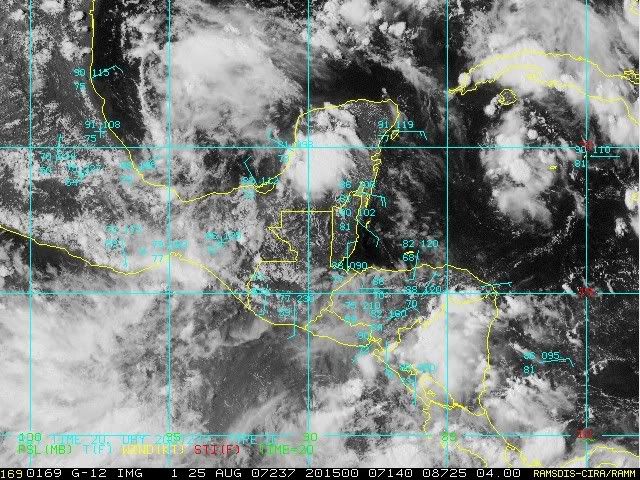
A BROAD AREA OF LOW PRESSURE ASSOCIATED WITH A TROPICAL WAVE IS
PRODUCING CLOUDINESS AND THUNDERSTORMS IN THE SOUTHWESTERN GULF OF
MEXICO. THIS SYSTEM IS FORECAST TO MOVE WESTWARD AND INLAND OVER
MEXICO ON SUNDAY WITH NO SIGNIFICANT DEVELOPMENT.

Image
0 likes   

User avatar
lrak
S2K Supporter
S2K Supporter
Posts: 1770
Age: 58
Joined: Thu Jun 21, 2007 2:48 pm
Location: Corpus Christi, TX

Re: BOC convection

#22 Postby lrak » Sat Aug 25, 2007 5:43 pm

0 likes   

Berwick Bay

Re: BOC convection

#23 Postby Berwick Bay » Sat Aug 25, 2007 6:13 pm

Yeah, just from a quick overview of the Basin, if you had to pick a spot with at least a chance, it would be the BOC. Upper level conditions appear more stable here, and there is already some TS activity. So its got a shot.
0 likes   

User avatar
HeeBGBz
Category 1
Category 1
Posts: 341
Age: 71
Joined: Sun Sep 03, 2006 3:25 pm
Location: Biloxi, MS

Re: BOC convection

#24 Postby HeeBGBz » Sat Aug 25, 2007 7:14 pm

Woah, look at that huge meatball of convection that sprang up over the Yucatan. That looks like it means business.

http://www.ssd.noaa.gov/goes/east/gmex/loop-rb.html
0 likes   

Cyclone1
Category 5
Category 5
Posts: 2739
Age: 33
Joined: Tue Jun 12, 2007 12:03 pm
Location: Florida

#25 Postby Cyclone1 » Sat Aug 25, 2007 7:21 pm

Wow, the Gulf is very convectionally-active... yeah it's a word... ok, fine I make up words, big deal.
0 likes   

User avatar
HURAKAN
Professional-Met
Professional-Met
Posts: 46086
Age: 38
Joined: Thu May 20, 2004 4:34 pm
Location: Key West, FL
Contact:

#26 Postby HURAKAN » Sat Aug 25, 2007 7:28 pm

Image

Image

Image

Just normal, diurnal convection, nothing to get excited about.
0 likes   

flwxwatcher
Category 4
Category 4
Posts: 926
Joined: Wed May 16, 2007 3:35 pm
Location: Central Florida

Re: BOC convection

#27 Postby flwxwatcher » Sat Aug 25, 2007 7:37 pm

The Gulf is primed for business if a Storm does get into the Gulf, as this link below shows.

http://wxmaps.org/pix/hurpot.html
0 likes   

User avatar
lrak
S2K Supporter
S2K Supporter
Posts: 1770
Age: 58
Joined: Thu Jun 21, 2007 2:48 pm
Location: Corpus Christi, TX

Re: BOC convection

#28 Postby lrak » Sat Aug 25, 2007 7:49 pm

0 likes   

Sanibel
Category 5
Category 5
Posts: 10375
Joined: Mon Aug 30, 2004 11:06 pm
Location: Offshore SW Florida

Re: BOC convection

#29 Postby Sanibel » Sat Aug 25, 2007 7:56 pm

Looks like something is trying to spin up there.
0 likes   

Ed Mahmoud

Re: BOC convection

#30 Postby Ed Mahmoud » Sat Aug 25, 2007 8:05 pm

The diurnal convection over the Yucatan will compete with the feature in the BOC for inflow. The BOC blob may come back once that weakens with nocturnal cooling. IMHO.

I still suspect, in my non-professional opinion, that Felix isn't named before September.
0 likes   

caneman

Re: BOC convection

#31 Postby caneman » Sat Aug 25, 2007 8:11 pm

The convection wouldn't compete with a potential developing low. It would actually get sucked in. IMHO. Need to watch this area as it has been persisting.
0 likes   

User avatar
lrak
S2K Supporter
S2K Supporter
Posts: 1770
Age: 58
Joined: Thu Jun 21, 2007 2:48 pm
Location: Corpus Christi, TX

Re: BOC convection

#32 Postby lrak » Sat Aug 25, 2007 8:25 pm

0 likes   

Stormcenter
S2K Supporter
S2K Supporter
Posts: 6684
Joined: Wed Sep 03, 2003 11:27 am
Location: Houston, TX

Re: BOC convection

#33 Postby Stormcenter » Sat Aug 25, 2007 8:45 pm

lrak wrote:http://www.ndbc.noaa.gov/station_page.php?station=42055

pressure holding.


Pretty stiff winds out there.
0 likes   

User avatar
HURAKAN
Professional-Met
Professional-Met
Posts: 46086
Age: 38
Joined: Thu May 20, 2004 4:34 pm
Location: Key West, FL
Contact:

#34 Postby HURAKAN » Sat Aug 25, 2007 9:10 pm

TROPICAL WEATHER OUTLOOK
NWS TPC/NATIONAL HURRICANE CENTER MIAMI FL
1030 PM EDT SAT AUG 25 2007

FOR THE NORTH ATLANTIC...CARIBBEAN SEA AND THE GULF OF MEXICO...

SHOWER ACTIVITY ASSOCIATED WITH A BROAD AREA OF LOW PRESSURE IN THE
SOUTHWESTERN GULF OF MEXICO HAS DIMINISHED.


TROPICAL CYCLONE FORMATION IS NOT EXPECTED DURING THE NEXT 48 HOURS.

$$

FORECASTER AVILA
_______________________
Another one bites the dust!!
0 likes   

Stormcenter
S2K Supporter
S2K Supporter
Posts: 6684
Joined: Wed Sep 03, 2003 11:27 am
Location: Houston, TX

Re: BOC convection

#35 Postby Stormcenter » Sat Aug 25, 2007 10:23 pm

There is definitely still some twisting motion still down there.

http://www.ssd.noaa.gov/goes/east/gmex/loop-vis.html
0 likes   

Rainband

Re:

#36 Postby Rainband » Sat Aug 25, 2007 10:44 pm

HURAKAN wrote:TROPICAL WEATHER OUTLOOK
NWS TPC/NATIONAL HURRICANE CENTER MIAMI FL
1030 PM EDT SAT AUG 25 2007

FOR THE NORTH ATLANTIC...CARIBBEAN SEA AND THE GULF OF MEXICO...

SHOWER ACTIVITY ASSOCIATED WITH A BROAD AREA OF LOW PRESSURE IN THE
SOUTHWESTERN GULF OF MEXICO HAS DIMINISHED.


TROPICAL CYCLONE FORMATION IS NOT EXPECTED DURING THE NEXT 48 HOURS.

$$

FORECASTER AVILA
_______________________
Another one bites the dust!!
Just in :D
0 likes   

User avatar
lrak
S2K Supporter
S2K Supporter
Posts: 1770
Age: 58
Joined: Thu Jun 21, 2007 2:48 pm
Location: Corpus Christi, TX

Re: BOC convection

#37 Postby lrak » Sun Aug 26, 2007 1:34 am

http://www.ndbc.noaa.gov/station_page.php?station=42055

winds are still gusty, and the convection is increasing late tonight. Its not 10:30pm :P
0 likes   

User avatar
lrak
S2K Supporter
S2K Supporter
Posts: 1770
Age: 58
Joined: Thu Jun 21, 2007 2:48 pm
Location: Corpus Christi, TX

Re: BOC convection

#38 Postby lrak » Sun Aug 26, 2007 7:16 am

still there....waiting on daylight. The Blob is alive this morning.
0 likes   

User avatar
tailgater
S2K Supporter
S2K Supporter
Posts: 3339
Joined: Sun Jul 11, 2004 9:13 pm
Location: St. Amant La.

Re: BOC convection

#39 Postby tailgater » Sun Aug 26, 2007 8:42 am

lrak wrote:still there....waiting on daylight. The Blob is alive this morning.

Yeah it's still there but it's getting very close to shore.
Radar, I don't know how to stitch these images together.

http://smn.cna.gob.mx/radares/rad-alva.gif
Sat loop
http://hadar.cira.colostate.edu/ramsdis ... al/173.jpg
There nothing else out there and I don't see anything in the near future, Dry air and TUTT.
0 likes   

User avatar
drezee
S2K Supporter
S2K Supporter
Posts: 3664
Joined: Mon Jun 09, 2003 12:49 pm
Location: FL

Re: BOC convection

#40 Postby drezee » Sun Aug 26, 2007 8:44 am

Convection is starting to fire near what can only be called a Low Level Center. This thing need to be onshore in less than 12 hours if the NHC doesn't want to be forced to classify it. Bupy 42055 has already had 25 mph 1-minute sustained winds this morning.
0 likes   


Return to “Talkin' Tropics”

Who is online

Users browsing this forum: HurricaneBelle, riapal, Sunnydays, texsn95 and 39 guests