Convection w/ inflow-West-Central Caribbean Sea
Moderator: S2k Moderators
Forum rules

The posts in this forum are NOT official forecasts and should not be used as such. They are just the opinion of the poster and may or may not be backed by sound meteorological data. They are NOT endorsed by any professional institution or STORM2K. For official information, please refer to products from the National Hurricane Center and National Weather Service.
-
caneman
Re: Convection w/ inflow 13n 75w
I think we have an LLC developing at 11N and 76W. You can see it on visible and there is bending of the coulds in that area. This area looks ready to pop. Surprised it isn't an invest yet.
0 likes
-
caneman
Re: Convection w/ inflow 13n 75w
By the way maybe mods or starter of post can change the topic to 11 and 76N as that looks to be much closer to a possible LLC
0 likes
Re: Convection w/ inflow-Central Caribbean Sea
Funny, that Colombian emergence point is identical to the system CMC developed prior to Erin.
Not sure what level that vorticity is at. It could be a healthy mid-level swirl with little surface reflection. (Synoptic) If not, it looks like something is getting going down there.
Not sure what level that vorticity is at. It could be a healthy mid-level swirl with little surface reflection. (Synoptic) If not, it looks like something is getting going down there.
0 likes
Re: Convection w/ inflow-Central Caribbean Sea
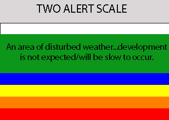
A LARGE AREA OF DISORGANIZED SHOWERS AND THUNDERSTORMS LOCATED OVER
THE CENTRAL CARIBBEAN IS ASSOCIATED WITH A TROPICAL WAVE. THERE
ARE NO SIGNS OF A CLOSED SURFACE CIRCULATION AND DEVELOPMENT..IF
ANY...IS EXPECTED TO BE SLOW TO OCCUR AS THE SYSTEM MOVES WESTWARD
AROUND 15 TO 20 MPH.
THE CENTRAL CARIBBEAN IS ASSOCIATED WITH A TROPICAL WAVE. THERE
ARE NO SIGNS OF A CLOSED SURFACE CIRCULATION AND DEVELOPMENT..IF
ANY...IS EXPECTED TO BE SLOW TO OCCUR AS THE SYSTEM MOVES WESTWARD
AROUND 15 TO 20 MPH.
0 likes

-
Emmett_Brown

- Category 5

- Posts: 1433
- Joined: Wed Aug 24, 2005 9:10 pm
- Location: Sarasota FL
Re: Convection w/ inflow-Central Caribbean Sea
RL3AO wrote:A LARGE AREA OF DISORGANIZED SHOWERS AND THUNDERSTORMS LOCATED OVER
THE CENTRAL CARIBBEAN IS ASSOCIATED WITH A TROPICAL WAVE. THERE
ARE NO SIGNS OF A CLOSED SURFACE CIRCULATION AND DEVELOPMENT..IF
ANY...IS EXPECTED TO BE SLOW TO OCCUR AS THE SYSTEM MOVES WESTWARD
AROUND 15 TO 20 MPH.
Ok, I really dont agree with the description of this area being a tropical wave. The latest surface map doesnt reflect a wave in the central Carribean:
http://www.opc.ncep.noaa.gov/UA/Atl_Tropics.gif
Tropical waves originate as mid level disturbances from Africa, and this clearly migrated N from South America. I also dont agree with the movement... i dont see W at 15-20. If anything, appears to be NW at a slower speed, perhaps 10-15. NHC is great, and i am not a pro met, but the description of this disturbance seems inaccurate.
0 likes

Re: Convection w/ inflow-Central Caribbean Sea
Well at least it now got some mention in the 530 two. 
0 likes
-
Dean4Storms
- S2K Supporter

- Posts: 6358
- Age: 62
- Joined: Sun Aug 31, 2003 1:01 pm
- Location: Miramar Bch. FL
-
wxman57

- Moderator-Pro Met

- Posts: 23127
- Age: 68
- Joined: Sat Jun 21, 2003 8:06 pm
- Location: Houston, TX (southwest)
Re: Convection w/ inflow-Central Caribbean Sea
Emmett_Brown wrote:
Ok, I really dont agree with the description of this area being a tropical wave. The latest surface map doesnt reflect a wave in the central Carribean:
http://www.opc.ncep.noaa.gov/UA/Atl_Tropics.gif
Tropical waves originate as mid level disturbances from Africa, and this clearly migrated N from South America. I also dont agree with the movement... i dont see W at 15-20. If anything, appears to be NW at a slower speed, perhaps 10-15. NHC is great, and i am not a pro met, but the description of this disturbance seems inaccurate.
Actually, it is a tropical wave, and the link you posted above shows it very well - it just wasn't drawn on the map. Note the isobar that "makes a wave" right over the disturbance. Don't know why it wasn't identified as such. I've been following this wave since it moved off the coast of Africa about 6 days ago.
Anyway, there may be a very, very weak low-level spin near 11N/76W. Problem is, an observing station on the coast of Venezuela just east of the apparent spin has been reporting a northerly wind rather than a southerly wind. With the strong ridge north of the system, it appears that a track westward into Central America may be most likely. Could spark a few storms in the BoC by Wednesday. May even have a brief shot at developing into a TD/TS before it moves inland into Mexico if it does slip far enough north to make it to the BoC, but I think that's about it.
0 likes
-
cycloneye

- Admin

- Posts: 148743
- Age: 69
- Joined: Thu Oct 10, 2002 10:54 am
- Location: San Juan, Puerto Rico
Re: Convection w/ inflow-Central Caribbean Sea
A NEW TROPICAL WAVE IS INTRODUCED ALONG 71W ON THE 1800 UTC
SURFACE MAP BASED ON SATELLITE IMAGERY...SFC OBSERVATIONS AND
THE CURACAO VERTICAL SOUNDING THAT SHOWED THE PASSAGE OF THE
WAVE THIS MORNING. A LARGE AREA OF DISORGANIZED SHOWERS AND
THUNDERSTORMS OVER THE CENTRAL CARIBBEAN IS ASSOCIATED WITH THIS
FEATURE. THERE ARE NO SIGNS OF A CLOSED SURFACE CIRCULATION AND
DEVELOPMENT..IF ANY...IS EXPECTED TO BE SLOW TO OCCUR AS THE
SYSTEM MOVES WESTWARD AROUND 15 TO 20 MPH. COMPUTER MODELS HAVE
MOISTURE FROM THIS WAVE REACHING THE CARIBBEAN PLAINS OF
NICARAGUA LATE MONDAY OR EARLY TUESDAY.
Oficially is a tropical wave per 8 PM Discussion by TPC.
0 likes
-
AnnularCane

- S2K Supporter
- Posts: 2949
- Joined: Thu Jun 08, 2006 9:18 am
- Location: Wytheville, VA
Re: Convection w/ inflow-Central Caribbean Sea
Doesn't sound like they're expecting it to be around very long.
0 likes
-
cycloneye
- Admin
- Posts: 148743
- Age: 69
- Joined: Thu Oct 10, 2002 10:54 am
- Location: San Juan, Puerto Rico
Re: Convection w/ inflow-Central Caribbean Sea
ABNT20 KNHC 270214
TWOAT
TROPICAL WEATHER OUTLOOK
NWS TPC/NATIONAL HURRICANE CENTER MIAMI FL
1030 PM EDT SUN AUG 26 2007
FOR THE NORTH ATLANTIC...CARIBBEAN SEA AND THE GULF OF MEXICO...
SHOWERS AND THUNDERSTORMS ASSOCIATED WITH A WEAK AREA OF LOW
PRESSURE LOCATED JUST OFF THE COAST OF CENTRAL MEXICO HAVE CHANGED
LITTLE IN ORGANIZATION THIS EVENING. THIS SYSTEM IS EXPECTED
TO MOVE INLAND LATER TONIGHT OR EARLY MONDAY...AND SIGNIFICANT
DEVELOPMENT IS UNLIKELY. HOWEVER...LOCALLY HEAVY RAINFALL IS
POSSIBLE OVER PORTIONS OF CENTRAL MEXICO DURING THE NEXT DAY OR SO
AS THE SYSTEM MOVES SLOWLY WESTWARD.
CLOUDINESS AND SHOWERS LOCATED OVER THE WEST-CENTRAL CARIBBEAN SEA
ARE ASSOCIATED WITH A TROPICAL WAVE. THERE ARE NO SIGNS OF A
CLOSED SURFACE CIRCULATION AND DEVELOPMENT..IF ANY...IS EXPECTED TO
BE SLOW TO OCCUR AS THE SYSTEM MOVES WESTWARD AROUND 15 TO 20 MPH.
ELSEWHERE...TROPICAL CYCLONE FORMATION IS NOT EXPECTED DURING THE
NEXT 48 HOURS.
$$
FORECASTER RHOME/PASCH
0 likes
-
Meso

- Category 5
- Posts: 1609
- Age: 39
- Joined: Mon Aug 09, 2004 12:14 pm
- Location: South Africa
- Contact:
000
ABNT20 KNHC 270924
TWOAT
TROPICAL WEATHER OUTLOOK
NWS TPC/NATIONAL HURRICANE CENTER MIAMI FL
530 AM EDT MON AUG 27 2007
FOR THE NORTH ATLANTIC...CARIBBEAN SEA AND THE GULF OF MEXICO...
SHOWERS AND THUNDERSTORMS OVER THE WESTERN GULF OF MEXICO ARE
ASSOCIATED WITH A WEAK AREA OF LOW PRESSURE ALONG THE EAST-CENTRAL
COAST OF MEXICO. SIGNIFICANT DEVELOPMENT OF THIS SYSTEM IS
UNLIKELY. HOWEVER...LOCALLY HEAVY RAINFALL IS POSSIBLE OVER
PORTIONS OF CENTRAL MEXICO DURING THE NEXT DAY OR SO AS THE SYSTEM
MOVES SLOWLY WESTWARD.
CLOUDINESS AND SHOWERS LOCATED OVER THE WEST-CENTRAL CARIBBEAN SEA
ARE ASSOCIATED WITH A TROPICAL WAVE. DEVELOPMENT..IF ANY...IS
EXPECTED TO BE SLOW TO OCCUR AS THE SYSTEM MOVES WESTWARD AROUND 15
TO 20 MPH.
ELSEWHERE...TROPICAL CYCLONE FORMATION IS NOT EXPECTED DURING THE
NEXT 48 HOURS.
$$
FORECASTER COBB/RHOME
0 likes
-
Frank P
- S2K Supporter
- Posts: 2779
- Joined: Fri Aug 29, 2003 10:52 am
- Location: Biloxi Beach, Ms
- Contact:
Re: Convection w/ inflow-West-Central Caribbean Sea
looks like the little system in the SouCar is following an upper level low to its NW....it still has some level of rotation and now appears to also be moving in a more WNWerly motion... convection has been on the increase off to the NE of the broad center of rotation.. will have to see if it can develop any convection closer to the center, if it has any shot at all of developing..
http://www.ssd.noaa.gov/goes/east/watl/loop-avn.html
http://www.ssd.noaa.gov/goes/east/watl/loop-avn.html
0 likes
-
Windsurfer_NYC
- Tropical Storm

- Posts: 233
- Joined: Wed Jun 07, 2006 3:27 pm
- Location: New York, NY
734
ABNT20 KNHC 271513
TWOAT
TROPICAL WEATHER OUTLOOK
NWS TPC/NATIONAL HURRICANE CENTER MIAMI FL
1130 AM EDT MON AUG 27 2007
FOR THE NORTH ATLANTIC...CARIBBEAN SEA AND THE GULF OF MEXICO...
THE WEAK AREA OF LOW PRESSURE NEAR THE EAST-CENTRAL COAST OF MEXICO
HAS MOVED INLAND. LOCALLY HEAVY RAINFALL REMAINS POSSIBLE...
HOWEVER...OVER PORTIONS OF CENTRAL AND NORTHEASTERN MEXICO DURING
THE NEXT DAY OR SO.
A TROPICAL WAVE OVER THE WEST-CENTRAL CARIBBEAN SEA IS PRODUCING
DISORGANIZED AND LIMITED SHOWER ACTIVITY. THIS SYSTEM WILL BE
INTERACTING WITH LAND DURING THE NEXT COUPLE OF DAYS...AND
SIGNIFICANT DEVELOPMENT IS NOT EXPECTED AS IT MOVES WESTWARD AT
ABOUT 15 TO 20 MPH.
ANOTHER TROPICAL WAVE IS LOCATED OVER THE FAR EASTERN ATLANTIC ABOUT
800 MILES WEST-SOUTHWEST OF THE CAPE VERDE ISLANDS. SLOW
DEVELOPMENT OF THIS SYSTEM IS POSSIBLE DURING THE NEXT COUPLE OF
DAYS AT IT MOVES WESTWARD AT 15 TO 20 MPH.
ELSEWHERE...TROPICAL CYCLONE FORMATION IS NOT EXPECTED DURING THE
NEXT 48 HOURS.
FORECASTER KNABB/ROBERTS
0 likes
Re: Convection w/ inflow-West-Central Caribbean Sea
Well-defined convection-less surface spiral near 12.5N-79W headed west for Nicaragua.
0 likes
Re: Convection w/ inflow-West-Central Caribbean Sea

Good convection burst over the north half. Watch this if it tracks north of expected track.
0 likes
Who is online
Users browsing this forum: No registered users and 29 guests