As i stated earlier this wave has lost most of its convection this evening and is engulfed in that dry, stable air which in all honestly means No development anytime soon.
Overall after looking at WV loops this wave has some slight potential but signficant development in the near term seems unlikely to me.The rest of the tropics are quiet for now.Adrian
Wave in Eastern Atlantic
Moderator: S2k Moderators
Forum rules

The posts in this forum are NOT official forecasts and should not be used as such. They are just the opinion of the poster and may or may not be backed by sound meteorological data. They are NOT endorsed by any professional institution or STORM2K. For official information, please refer to products from the National Hurricane Center and National Weather Service.
-
windstorm99

- S2K Supporter

- Posts: 1578
- Age: 48
- Joined: Sat May 26, 2007 8:10 am
- Location: Miami, Florida
- Contact:
Re: Wave in Eastern Atlantic
0 likes
-
miamicanes177
- Category 5

- Posts: 1131
- Joined: Tue Aug 01, 2006 10:53 pm
Re: Wave in Eastern Atlantic
windstorm99 wrote:Jeff masters theatrics!I think jeff masters knows exactly what he is talking about and to be honest makes perfect sence when you have an extremely powerful hurricane moving through the area.Jeff masters has tons of experience and his knowledge is greatly appreciated on WU and in the tropical weather community.
ConvergenceZone wrote:Dude, no offense, but can you please back up this statement with some data?? I think it was Cycloneye that posted the map of the obviously cooled waters, and what do you mean "stronger than Dean ever was"? Remember, this isn't 2005 nor is it "The day after tomorrow"
SST and TCHP is higher today than it was August 17 as Dean entered the Caribbean. Proof below:tolakram wrote:Did you read the blog entry? Why are you so quick to insult Masters? You make the above claim and back it up with nothing? Inappropriate post in my opinion.
SST
http://www.aoml.noaa.gov/phod/dataphod1/work/HHP/NEW/2007238casst.png
http://www.aoml.noaa.gov/phod/dataphod1/work/HHP/NEW/2007229casst.png
TCHP
http://www.aoml.noaa.gov/phod/dataphod1/work/HHP/NEW/2007238ca.jpg
http://www.aoml.noaa.gov/phod/dataphod1/work/HHP/NEW/2007229ca.jpg
0 likes
-
HurricaneMaster_PR

- Category 2

- Posts: 795
- Joined: Tue Jul 22, 2003 6:23 pm
- Location: San Juan, Puerto Rico
Re: Wave in Eastern Atlantic
TROPICAL WEATHER OUTLOOK
NWS TPC/NATIONAL HURRICANE CENTER MIAMI FL
1030 PM EDT MON AUG 27 2007
FOR THE NORTH ATLANTIC...CARIBBEAN SEA AND THE GULF OF MEXICO...
A TROPICAL WAVE OVER THE WESTERN CARIBBEAN SEA IS PRODUCING
DISORGANIZED SHOWERS AND THUNDERSTORMS. THIS SYSTEM IS EXPECTED TO
MOVE WESTWARD OVER CENTRAL AMERICA DURING THE NEXT COUPLE OF DAYS
WITH NO SIGNIFICANT DEVELOPMENT.
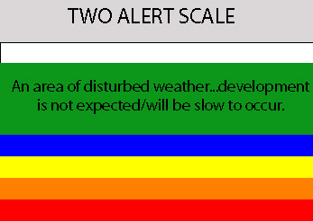
SHOWER AND THUNDERSTORM ACTIVITY ASSOCIATED WITH A TROPICAL WAVE
LOCATED OVER THE FAR EASTERN ATLANTIC...ABOUT 900 MILES
WEST-SOUTHWEST OF THE CAPE VERDE ISLANDS...REMAINS LIMITED AND
DISORGANIZED. DEVELOPMENT...IF ANY...IS EXPECTED TO BE SLOW TO
OCCUR AS THE SYSTEM MOVES WESTWARD AT 15 TO 20 MPH
ELSEWHERE...TROPICAL CYCLONE FORMATION IS NOT EXPECTED DURING THE
NEXT 48 HOURS.
$$
FORECASTER RHOME
NWS TPC/NATIONAL HURRICANE CENTER MIAMI FL
1030 PM EDT MON AUG 27 2007
FOR THE NORTH ATLANTIC...CARIBBEAN SEA AND THE GULF OF MEXICO...
A TROPICAL WAVE OVER THE WESTERN CARIBBEAN SEA IS PRODUCING
DISORGANIZED SHOWERS AND THUNDERSTORMS. THIS SYSTEM IS EXPECTED TO
MOVE WESTWARD OVER CENTRAL AMERICA DURING THE NEXT COUPLE OF DAYS
WITH NO SIGNIFICANT DEVELOPMENT.
SHOWER AND THUNDERSTORM ACTIVITY ASSOCIATED WITH A TROPICAL WAVE
LOCATED OVER THE FAR EASTERN ATLANTIC...ABOUT 900 MILES
WEST-SOUTHWEST OF THE CAPE VERDE ISLANDS...REMAINS LIMITED AND
DISORGANIZED. DEVELOPMENT...IF ANY...IS EXPECTED TO BE SLOW TO
OCCUR AS THE SYSTEM MOVES WESTWARD AT 15 TO 20 MPH
ELSEWHERE...TROPICAL CYCLONE FORMATION IS NOT EXPECTED DURING THE
NEXT 48 HOURS.
$$
FORECASTER RHOME
0 likes
-
cycloneye

- Admin

- Posts: 148743
- Age: 69
- Joined: Thu Oct 10, 2002 10:54 am
- Location: San Juan, Puerto Rico
Re: Wave in Eastern Atlantic
..SOME SLOW DEVELOPMENT OF
THIS SYSTEM IS POSSIBLE DURING THE NEXT COUPLE OF DAYS AT IT MOVES
WESTWARD AT 15 TO 20 MPH.
0 likes

-
'CaneFreak

- Category 5
- Posts: 1487
- Joined: Mon Jun 05, 2006 10:50 am
- Location: New Bern, NC
Re: Wave in Eastern Atlantic
windstorm99 wrote:As i stated earlier this wave has lost most of its convection this evening and is engulfed in that dry, stable air which in all honestly means No development anytime soon.
Overall after looking at WV loops this wave has some slight potential but signficant development in the near term seems unlikely to me.The rest of the tropics are quiet for now.Adrian
Would you mind pointing out to me the dry stable air? Keeping in mind that our wave is down near 10 N and 35 to 40 West...I think you have fell into the trap again of blaming SAL, dry air, etc. argument....How 'bout a new one? How about this wave is PULSATING!!! ALL TROPICAL WAVES pulsate, there is times when the convection dies down a bit and times when the convection flares up...its a vigorous cycle.
http://cimss.ssec.wisc.edu/tropic/real- ... t48hrs.gif
I am not trying to pick on just you, but this applies to everyone on this board. When convection goes down, EVERYONE goes to blaming SAL, dry air, shear, etc like it came out of a novel or something. Most of the negative factors are gone for the most part. The only thing that I can see that might be a problem is the fact that it is a rather weak circulation. It needs a rather vigorous circulation in order to keep going and I just dont see that...it has a poor circulation. Now, if you will give it another couple of days before writing it off, then it may develop. Just not developing right now.
Last edited by 'CaneFreak on Mon Aug 27, 2007 9:18 pm, edited 1 time in total.
0 likes
-
ConvergenceZone
.gif)
- Category 5
- Posts: 5241
- Joined: Fri Jul 29, 2005 1:40 am
- Location: Northern California
Re: Wave in Eastern Atlantic=10:30 PM EDT TWO Posted on page 7
LOL, it seems like whenever we give attention to a wave, it goes poof on us, oh well, it was worth a shot to look at anyway........ Next? LOL
0 likes
Re: Wave in Eastern Atlantic=10:30 PM EDT TWO Posted on page 7
ConvergenceZone wrote:LOL, it seems like whenever we give attention to a wave, it goes poof on us, oh well, it was worth a shot to look at anyway........ Next? LOL
Does diurnal minimum ring a bell?
Most likely we will have TD by 5pm posts after convection flares up tonight.
0 likes
-
Brent
- S2K Supporter
- Posts: 38496
- Age: 37
- Joined: Sun May 16, 2004 10:30 pm
- Location: Tulsa Oklahoma
- Contact:
Re: Wave in Eastern Atlantic=10:30 PM EDT TWO Posted on page 7

Almost September and worldwide the tropics are boring. What is going on?
0 likes
-
HurricaneMaster_PR
- Category 2
- Posts: 795
- Joined: Tue Jul 22, 2003 6:23 pm
- Location: San Juan, Puerto Rico
Re: Wave in Eastern Atlantic=10:30 PM EDT TWO Posted on page 7
As of the image of 9:45pm we can see convection flaring up just west of the weak circulation..Lets see if this trend continues...

0 likes
-
'CaneFreak
- Category 5
- Posts: 1487
- Joined: Mon Jun 05, 2006 10:50 am
- Location: New Bern, NC
Re: Re:
'CaneFreak wrote:'CaneFreak wrote:http://www.weather.unisys.com/hurricane/shr_48.gif
Look at that shear at 48 hours...almost non-existent. I've been saying...and I am going to say it again...here we go!!! September-October-November could be busier than we have seen in recent years. Just a side note: we have not seen a La Nina pattern in several years....which is probably why most folks are confused as to why we havent seen a lot of activity...look at the last La Nina pattern...I believe it was back in 1999...FLOYD? Ring any bells? The "F" storm in early September...HMMMMMM....thats all I am going to say...
http://www.weather.unisys.com/hurricane ... index.html
In addition, thats right, I am not thru yet...there were 10 STORMS IN THE SEPT-NOV TIME FRAME...Derek you were correct...I want to emphasize it a little more..batten down the hatches folks, 'cause mother nature is about to explode!!! There is too much energy out there that needs to be removed for us to see another '06...trust me folks...and its all going to start with our current system. So get ready now!!! This wave is starting to show signs of an "S-shape" as we call it in meteorology on visible sat images...that is a good sign for development.
This is for you Brent
0 likes
-
gatorcane

- S2K Supporter
- Posts: 23703
- Age: 47
- Joined: Sun Mar 13, 2005 3:54 pm
- Location: Boca Raton, FL
Re: Wave in Eastern Atlantic=10:30 PM EDT TWO Posted on page 7
folks it doesn't look good for this wave...
what is wrong with the Atlantic?
what is wrong with the Atlantic?
0 likes
-
cycloneye
- Admin
- Posts: 148743
- Age: 69
- Joined: Thu Oct 10, 2002 10:54 am
- Location: San Juan, Puerto Rico
Re: Wave in Eastern Atlantic=10:30 PM EDT TWO Posted on page 7
gatorcane wrote:folks it doesn't look good for this wave...
what is wrong with the Atlantic?
No El Nino in 2007 so the blame has to go to other factors.
0 likes
Re: Wave in Eastern Atlantic=10:30 PM EDT TWO Posted on page 7
It is juicy, warm, and humid outside tonight with tropical downpours. The rainy season is finally turning on down here. I think you'll see the season follow soon.
This wave could recover. We'll see.
This wave could recover. We'll see.
0 likes
-
'CaneFreak
- Category 5
- Posts: 1487
- Joined: Mon Jun 05, 2006 10:50 am
- Location: New Bern, NC
Re: Wave in Eastern Atlantic=10:30 PM EDT TWO Posted on page 7
gatorcane wrote:folks it doesn't look good for this wave...
what is wrong with the Atlantic?
Wanna little cheese with that whine...
0 likes
-
Brent
- S2K Supporter
- Posts: 38496
- Age: 37
- Joined: Sun May 16, 2004 10:30 pm
- Location: Tulsa Oklahoma
- Contact:
Re: Wave in Eastern Atlantic=10:30 PM EDT TWO Posted on page 7
gatorcane wrote:folks it doesn't look good for this wave...
what is wrong with the Atlantic?
I don't know but I'm ready for something BIG. Dean feels like it was months ago right now, and plus it was pretty much a non-story as far as the landfalls went.
I honestly thought Dean was the start of activity, instead it was just a fluke.
0 likes
-
AtlanticWind

- S2K Supporter
- Posts: 1898
- Age: 67
- Joined: Sun Aug 08, 2004 9:57 pm
- Location: Plantation,Fla
Re: Wave in Eastern Atlantic=10:30 PM EDT TWO Posted on page 7
Looks like a burst of convection starting near the low center
0 likes
-
hurricanetrack

- HurricaneTrack.com
- Posts: 1781
- Joined: Tue Dec 02, 2003 10:46 pm
- Location: Wilmington, NC
- Contact:
Yeah, that wave/surface low will likely not develop. Again, I point to the modern global models which now have even more data in them about this wave as each hour passes (well not each hour but you get the idea)- and none of the models show this thing developing much at all. There is a lot of dry air out ahead of this system- just look at any WV image and you'll see.
Looks like we'll have to wait until mid-September before we see any real action. Even then, it could be quite a long September if the lid comes off!
Looks like we'll have to wait until mid-September before we see any real action. Even then, it could be quite a long September if the lid comes off!
0 likes

Re: Wave in Eastern Atlantic=10:30 PM EDT TWO Posted on page 7
Brent wrote:gatorcane wrote:folks it doesn't look good for this wave...
what is wrong with the Atlantic?
I don't know but I'm ready for something BIG. Dean feels like it was months ago right now, and plus it was pretty much a non-story as far as the landfalls went.
I honestly thought Dean was the start of activity, instead it was just a fluke.
That's just...I don't know....kinda scary.
You want something big compared to Dean?
Like, what, global thermonuclear war?
0 likes
Who is online
Users browsing this forum: No registered users and 35 guests