Katrina Anniversary Thread

This is the general tropical discussion area. Anyone can take their shot at predicting a storms path.

Moderator: S2k Moderators

Forum rules

The posts in this forum are NOT official forecasts and should not be used as such. They are just the opinion of the poster and may or may not be backed by sound meteorological data. They are NOT endorsed by any professional institution or STORM2K. For official information, please refer to products from the National Hurricane Center and National Weather Service.

Help Support Storm2K
Message
Author
User avatar
LAwxrgal
S2K Supporter
S2K Supporter
Posts: 1763
Joined: Tue Jul 06, 2004 1:05 pm
Location: Reserve, LA (30 mi west of NOLA)

Re: Katrina Anniversary Thread

#101 Postby LAwxrgal » Tue Aug 28, 2007 9:40 pm

I can't help but think back to two years ago. My life is significantly different from the way it was before Katrina hit. I mean, it's like a 180 degree difference.

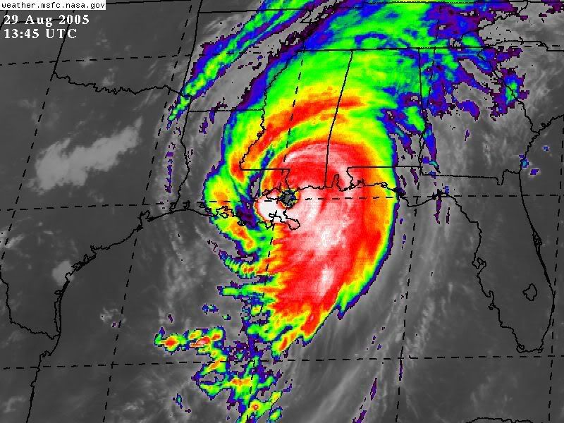
I remember that crystal-clear Sunday morning I woke up and saw Katrina was a Category 5 hurricane headed straight for me. I can't remember ever being more scared in my life.
Well, my aunt (who lived in New Orleans) died on September 4, 2005, in New Orleans. I can't help but think she'd still be alive if Katrina hadn't hit. Rest in peace Aunt Fran. My story of my experiences with Katrina are detailed in a post in the Hurricane Recovery and Aftermath forum.

I'm not around Storm2K as much as I used to be, and there's a reason for that. I've gotten a new job (well a job within the last two years), and that's taking up most of my time. I still have an interest in weather, but it's more of a healthy respect now rather than an all-out fascination like it used to be. A lot of this is because of the effects of Katrina on my life and those of relatives and friends, but a lot of it is also because of the changes that have taken place in my life within the last two years. I used to stay up nights tracking hurricanes. Now, I don't do that much anymore. I actually believe the last hurricane I tracked seriously was Katrina. :lol:
0 likes   

Derek Ortt

#102 Postby Derek Ortt » Tue Aug 28, 2007 9:56 pm

Perhaps we should abandon the middle of the country too. After all Yellowstone could go at any time.

Yellowstone also has a return time of 600,000 years. We can live with that risk. What we cannot live with is major cities having a return time of less than 50 years... the costs outweigh the benefits
0 likes   

User avatar
dhweather
S2K Supporter
S2K Supporter
Posts: 6199
Joined: Sat Aug 14, 2004 9:29 pm
Location: Heath, TX
Contact:

Re: Katrina Anniversary Thread

#103 Postby dhweather » Tue Aug 28, 2007 10:16 pm

The video I made right after Katrina:

http://www.youtube.com/watch?v=ujQwTQ8JnNc
0 likes   

User avatar
Ptarmigan
Category 5
Category 5
Posts: 5316
Joined: Wed Aug 16, 2006 9:06 pm

Re: Katrina Anniversary Thread

#104 Postby Ptarmigan » Tue Aug 28, 2007 10:24 pm

Downdraft wrote:Perhaps we should abandon the middle of the country too. After all Yellowstone could go at any time. That of course was said tongue in cheek. My major concern is does anyone think New Orleans is any safer levee wise today than it was before Katrina? From what I've read about the corruption on the levee boards there we rebuilt them so they can fail again. I for one don't like throwing good money after bad. You build a city in a bowl, you change the natural flood plains of the Mississippi river and you design a system that can't meet worst case scenarios so unless we wise up anyone that moved away from there is better for it.


Yellowstone erupts every 600,000 years and volcanic eruptions are harder to predict, like earthquakes. At least with hurricanes, we can sort of predict where they will go. There are certain risks that are acceptable. Also, the middle of America has less people than on the coast. The Mayans knew about hurricanes and decided to go further inland. As for New Orleans, the wetlands are disappearing and something has to be done about it. Storm surges would be lowered by marshes and more than likely New Orleans could have less damage from a hurricane.
0 likes   

User avatar
Ptarmigan
Category 5
Category 5
Posts: 5316
Joined: Wed Aug 16, 2006 9:06 pm

Re: Katrina Anniversary Thread

#105 Postby Ptarmigan » Tue Aug 28, 2007 10:29 pm

Those satellite images of Katrina as a Category 5 and making landfall really haunt me. I can't stop thinking about it.
:eek: :cry:
0 likes   

User avatar
Category 5
Category 5
Category 5
Posts: 10074
Age: 35
Joined: Sun Feb 11, 2007 10:00 pm
Location: New Brunswick, NJ
Contact:

Re: Katrina Anniversary Thread

#106 Postby Category 5 » Tue Aug 28, 2007 10:55 pm

This came out about this time

ZCZC MIATCPAT2 ALL
TTAA00 KNHC DDHHMM
BULLETIN
HURRICANE KATRINA INTERMEDIATE ADVISORY NUMBER 25A
NWS TPC/NATIONAL HURRICANE CENTER MIAMI FL
MIDNIGHT CDT MON AUG 29 2005

...POTENTIALLY CATASTROPHIC CATEGORY FIVE HURRICANE KATRINA
CONTINUES TO APPROACH THE NORTHERN GULF COAST...
...SUSTAINED HURRICANE-FORCE WINDS NEARING THE SOUTHEASTERN
LOUISIANA COAST...

A HURRICANE WARNING IS IN EFFECT FOR THE NORTH CENTRAL GULF COAST
FROM MORGAN CITY LOUISIANA EASTWARD TO THE ALABAMA/FLORIDA
BORDER...INCLUDING THE CITY OF NEW ORLEANS AND LAKE PONTCHARTRAIN.
PREPARATIONS TO PROTECT LIFE AND PROPERTY SHOULD BE RUSHED TO
COMPLETION.

A TROPICAL STORM WARNING AND A HURRICANE WATCH ARE IN EFFECT FROM
EAST OF THE ALABAMA/FLORIDA BORDER TO DESTIN FLORIDA...AND FROM
WEST OF MORGAN CITY TO INTRACOASTAL CITY LOUISIANA.

A TROPICAL STORM WARNING IS ALSO IN EFFECT FROM DESTIN FLORIDA
EASTWARD TO INDIAN PASS FLORIDA...AND FROM INTRACOASTAL CITY
LOUISIANA WESTWARD TO CAMERON LOUISIANA.

FOR STORM INFORMATION SPECIFIC TO YOUR AREA...INCLUDING POSSIBLE
INLAND WATCHES AND WARNINGS...PLEASE MONITOR PRODUCTS ISSUED
BY YOUR LOCAL WEATHER OFFICE.

AT MIDNIGHT CDT...0500Z...THE CENTER OF HURRICANE KATRINA WAS
LOCATED NEAR LATITUDE 27.9 NORTH...LONGITUDE 89.5 WEST OR ABOUT
90 MILES SOUTH-SOUTHWEST OF THE MOUTH OF THE MISSISSIPPI RIVER
AND ABOUT 150 MILES SOUTH-SOUTHEAST OF NEW ORLEANS LOUISIANA.

KATRINA IS MOVING TOWARD THE NORTH-NORTHWEST NEAR 10 MPH...AND A
TURN TO THE NORTH IS EXPECTED OVER THE NEXT 12 TO 24 HOURS. ON THE
FORECAST TRACK THE CENTER OF THE HURRICANE WILL BE VERY NEAR THE
NORTHERN GULF COAST MONDAY MORNING. HOWEVER...CONDITIONS ARE
ALREADY DETERIORATING ALONG PORTIONS OF THE CENTRAL AND
NORTHEASTERN GULF COAST...AND WILL CONTINUE TO WORSEN THROUGH THE
NIGHT.

MAXIMUM SUSTAINED WINDS REMAIN NEAR 160 MPH WITH HIGHER GUSTS.
KATRINA IS A CATEGORY FIVE HURRICANE ON THE SAFFIR-SIMPSON SCALE.
SOME FLUCTUATIONS IN STRENGTH ARE LIKELY PRIOR TO LANDFALL...AND
KATRINA IS EXPECTED TO MAKE LANDFALL AT EITHER CATEGORY FOUR OR
FIVE INTENSITY. WINDS AFFECTING THE UPPER FLOORS OF HIGH-RISE
BUILDINGS WILL BE SIGNIFICANTLY STRONGER THAN THOSE NEAR GROUND
LEVEL.

KATRINA REMAINS A VERY LARGE HURRICANE. HURRICANE FORCE WINDS EXTEND
OUTWARD UP TO 105 MILES FROM THE CENTER...AND TROPICAL STORM FORCE
WINDS EXTEND OUTWARD UP TO 230 MILES. A WIND GUST TO 98 MPH WAS
RECENTLY REPORTED FROM SOUTHWEST PASS LOUISIANA.

THE ESTIMATED MINIMUM CENTRAL PRESSURE IS 908 MB...26.81 INCHES.
AN AIR FORCE RESERVE UNIT RECONNAISSANCE AIRCRAFT IS CURRENTLY
INVESTIGATING KATRINA.

COASTAL STORM SURGE FLOODING OF 18 TO 22 FEET ABOVE NORMAL TIDE
LEVELS...LOCALLY AS HIGH AS 28 FEET...ALONG WITH LARGE AND DANGEROUS
BATTERING WAVES...CAN BE EXPECTED NEAR AND TO THE EAST OF WHERE THE
CENTER MAKES LANDFALL. SOME LEVEES IN THE GREATER NEW ORLEANS AREA
COULD BE OVERTOPPED. SIGNIFICANT STORM SURGE FLOODING WILL OCCUR
ELSEWHERE ALONG THE CENTRAL AND NORTHEASTERN GULF OF MEXICO COAST.

RAINFALL TOTALS OF 5 TO 10 INCHES...WITH ISOLATED MAXIMUM AMOUNTS OF
15 INCHES...ARE POSSIBLE ALONG THE PATH OF KATRINA ACROSS THE GULF
COAST AND THE TENNESSEE VALLEY. RAINFALL TOTALS OF 4 TO 8 INCHES
ARE POSSIBLE ACROSS THE OHIO VALLEY INTO THE EASTERN GREAT LAKES
REGION TUESDAY AND WEDNESDAY.

ISOLATED TORNADOES WILL BE POSSIBLE THIS EVENING OVER SOUTHEASTERN
LOUISIANA...SOUTHERN MISSISSIPPI...SOUTHERN ALABAMA...AND OVER THE
FLORIDA PANHANDLE TONIGHT.

REPEATING THE MIDNIGHT CDT POSITION...27.9 N... 89.5 W. MOVEMENT
TOWARD...NORTH-NORTHWEST NEAR 10 MPH. MAXIMUM SUSTAINED
WINDS...160 MPH. MINIMUM CENTRAL PRESSURE... 908 MB.

AN INTERMEDIATE ADVISORY WILL BE ISSUED BY THE NATIONAL
HURRICANE CENTER AT 2 AM CDT FOLLOWED BY THE NEXT
COMPLETE ADVISORY AT 4 AM CDT.

FORECASTER STEWART


$$
0 likes   

User avatar
Category 5
Category 5
Category 5
Posts: 10074
Age: 35
Joined: Sun Feb 11, 2007 10:00 pm
Location: New Brunswick, NJ
Contact:

Re: Katrina Anniversary Thread

#107 Postby Category 5 » Tue Aug 28, 2007 11:06 pm

ZCZC MIATCPAT2 ALL
TTAA00 KNHC DDHHMM CCA
BULLETIN
HURRICANE KATRINA INTERMEDIATE ADVISORY NUMBER 26A...CORRECTED
NWS TPC/NATIONAL HURRICANE CENTER MIAMI FL
6 AM CDT MON AUG 29 2005

CORRECTED TIMES TO 6 AM CDT

...EXTREMELY DANGEROUS CATEGORY FOUR HURRICANE KATRINA PREPARING
TO MOVE ONSHORE NEAR SOUTHERN PLAQUEMINES PARISH LOUISIANA...
...HURRICANE-FORCE WIND GUSTS OCCURRING OVER MOST OF SOUTHEASTERN
LOUISIANA...IN THE NEW ORLEANS METROPOLITAN AREA...AND AS FAR
EAST AS THE CHANDELEUR ISLANDS...

A HURRICANE WARNING IS IN EFFECT FOR THE NORTH CENTRAL GULF COAST
FROM MORGAN CITY LOUISIANA EASTWARD TO THE ALABAMA/FLORIDA
BORDER...INCLUDING THE CITY OF NEW ORLEANS AND LAKE PONTCHARTRAIN.
PREPARATIONS TO PROTECT LIFE AND PROPERTY SHOULD HAVE BEEN
COMPLETED.

A TROPICAL STORM WARNING AND A HURRICANE WATCH ARE IN EFFECT FROM
EAST OF THE ALABAMA/FLORIDA BORDER TO DESTIN FLORIDA...AND FROM
WEST OF MORGAN CITY TO INTRACOASTAL CITY LOUISIANA.

A TROPICAL STORM WARNING IS ALSO IN EFFECT FROM DESTIN FLORIDA
EASTWARD TO INDIAN PASS FLORIDA...AND FROM INTRACOASTAL CITY
LOUISIANA WESTWARD TO CAMERON LOUISIANA.

FOR STORM INFORMATION SPECIFIC TO YOUR AREA...INCLUDING POSSIBLE
INLAND WATCHES AND WARNINGS...PLEASE MONITOR PRODUCTS ISSUED
BY YOUR LOCAL WEATHER OFFICE.

AT 6 AM CDT...1100Z...THE CENTER OF MAJOR HURRICANE KATRINA WAS
LOCATED NEAR LATITUDE 29.1 NORTH... LONGITUDE 89.6 WEST OR ABOUT
MIDWAY BETWEEN GRAND ISLE AND THE MOUTH OF THE MISSISSIPPI RIVER.
THIS IS ALSO ABOUT 70 MILES SOUTH-SOUTHEAST OF NEW ORLEANS
LOUISIANA AND ABOUT 95 MILES SOUTH-SOUTHWEST OF BILOXI MISSISSIPPI.

KATRINA IS MOVING TOWARD THE NORTH NEAR 15 MPH... AND THIS
MOTION IS FORECAST TO CONTINUE TODAY. A GRADUAL TURN TOWARD THE
NORTH-NORTHEAST AT A SLIGHTLY FASTER FORWARD SPEED IS EXPECTED
LATER TONIGHT AND ON TUESDAY. ON THE FORECAST TRACK...KATRINA WILL
MOVE ONSHORE THE SOUTHERN COAST OF PLAQUEMINES PARISH NEAR EMPIRE
AND BURAS LOUSIANA WITHIN THE ENXT HOUR...AND REACH THE
LOUISIANA-MISSISSIPPI BORDER AREA BY EARLY AFTERNOON. CONDITIONS
WILL CONTINUE TO STEADILY DETERIORATE OVER CENTRAL AND SOUTHEASTERN
LOUISIANA...SOUTHERN MISSISSIPPI...AND SOUTHERN ALABAMA THROUGHOUT
THE DAY.

MAXIMUM SUSTAINED WINDS ARE NEAR 145 MPH...WITH HIGHER
GUSTS. KATRINA IS A STRONG CATEGORY FOUR HURRICANE ON THE
SAFFIR-SIMPSON SCALE. SOME FLUCTUATIONS IN STRENGTH ARE LIKELY
PRIOR TO LANDFALL...BUT KATRINA IS EXPECTED TO MAKE LANDFALL AS
A CATEGORY FOUR HURRICANE. WINDS AFFECTING THE UPPER FLOORS OF
HIGH-RISE BUILDINGS WILL BE SIGNIFICANTLY STRONGER THAN THOSE NEAR
GROUND LEVEL.

KATRINA REMAINS A VERY LARGE HURRICANE. HURRICANE FORCE WINDS EXTEND
OUTWARD UP TO 120 MILES FROM THE CENTER...AND TROPICAL STORM FORCE
WINDS EXTEND OUTWARD UP TO 230 MILES. DURING THE PAST HOUR...A
SUSTAINED WIND OF 56 MPH WITH A GUST TO 85 MPH WAS REPORTED AT NEW
ORLEANS LAKEFRONT AIRPORT...AND A SUSTAINED WIND OF 74 MPH WITH A
GUST TO 96 MPH WAS REPORTED AT THE NAVAL AIR STATION IN BELLE
CHASSE LOUISIANA.

THE MINIMUM CENTRAL PRESSURE RECENTLY REPORTED BY AN AIR FORCE
RESERVE UNIT RECONNAISSANCE AIRCRAFT WAS 918 MB...27.11 INCHES.

COASTAL STORM SURGE FLOODING OF 18 TO 22 FEET ABOVE NORMAL TIDE
LEVELS...LOCALLY AS HIGH AS 28 FEET...ALONG WITH LARGE AND DANGEROUS
BATTERING WAVES...CAN BE EXPECTED NEAR AND TO THE EAST OF WHERE THE
CENTER MAKES LANDFALL. SOME LEVEES IN THE GREATER NEW ORLEANS AREA
COULD BE OVERTOPPED. SIGNIFICANT STORM SURGE FLOODING WILL OCCUR
ELSEWHERE ALONG THE CENTRAL AND NORTHEASTERN GULF OF MEXICO COAST.
NOAA BUOY 42040 LOCATED ABOUT 50 MILES EAST OF THE MOUTH OF THE
MISSISSIPPI RIVER RECENTLY REPORTED WAVES HEIGHTS OF AT LEAST 47
FEET.

RAINFALL TOTALS OF 5 TO 10 INCHES...WITH ISOLATED MAXIMUM AMOUNTS OF
15 INCHES...ARE POSSIBLE ALONG THE PATH OF KATRINA ACROSS THE GULF
COAST AND THE TENNESSEE VALLEY. RAINFALL TOTALS OF 4 TO 8 INCHES
ARE POSSIBLE ACROSS THE OHIO VALLEY INTO THE EASTERN GREAT LAKES
REGION TUESDAY AND WEDNESDAY.

SCATTERED TORNADOES WILL BE POSSIBLE TODAY OVER SOUTHEASTERN
LOUISIANA... SOUTHERN MISSISSIPPI...SOUTHERN ALABAMA...AND OVER
THE FLORIDA PANHANDLE.

REPEATING THE 6 AM CDT POSITION...29.1 N... 89.6 W. MOVEMENT
TOWARD...NORTH NEAR 15 MPH. MAXIMUM SUSTAINED
WINDS...145 MPH. MINIMUM CENTRAL PRESSURE... 918 MB.

AN INTERMEDIATE ADVISORY WILL BE ISSUED BY THE NATIONAL
HURRICANE CENTER AT 8 AM CDT FOLLOWED BY THE NEXT
COMPLETE ADVISORY AT 10 AM CDT.

FORECASTER STEWART


$$
NNNN

ZCZC MIATCPAT2 ALL
TTAA00 KNHC DDHHMM
BULLETIN
HURRICANE KATRINA INTERMEDIATE ADVISORY NUMBER 26B
NWS TPC/NATIONAL HURRICANE CENTER MIAMI FL
8 AM CDT MON AUG 29 2005

...LARGE AND EXTREMELY DANGEROUS CATEGORY FOUR HURRICANE KATRINA
POUNDING SOUTHEASTERN LOUISIANA AND SOUTHERN MISSISSIPPI...

A HURRICANE WARNING IS IN EFFECT FOR THE NORTH CENTRAL GULF COAST
FROM MORGAN CITY LOUISIANA EASTWARD TO THE ALABAMA/FLORIDA
BORDER...INCLUDING THE CITY OF NEW ORLEANS AND LAKE PONTCHARTRAIN.

A TROPICAL STORM WARNING AND A HURRICANE WATCH ARE IN EFFECT FROM
EAST OF THE ALABAMA/FLORIDA BORDER TO DESTIN FLORIDA...AND FROM
WEST OF MORGAN CITY TO INTRACOASTAL CITY LOUISIANA.

A TROPICAL STORM WARNING IS ALSO IN EFFECT FROM DESTIN FLORIDA
EASTWARD TO INDIAN PASS FLORIDA...AND FROM INTRACOASTAL CITY
LOUISIANA WESTWARD TO CAMERON LOUISIANA.

FOR STORM INFORMATION SPECIFIC TO YOUR AREA...INCLUDING POSSIBLE
INLAND WATCHES AND WARNINGS...PLEASE MONITOR PRODUCTS ISSUED
BY YOUR LOCAL WEATHER OFFICE.

AT 8 AM CDT...1300Z...THE CENTER OF HURRICANE KATRINA WAS LOCATED
NEAR LATITUDE 29.7 NORTH... LONGITUDE 89.6 WEST OR ABOUT 40 MILES
SOUTHEAST OF NEW ORLEANS LOUISIANA AND ABOUT 65 MILES SOUTHWEST OF
BILOXI MISSISSIPPI.

KATRINA IS MOVING TOWARD THE NORTH NEAR 15 MPH...AND A GRADUAL TURN
TO THE NORTH-NORTHEAST AT A SLIGHTLY FASTER FORWARD SPEED IS
EXPECTED OVER THE NEXT 24 HOURS. ON THIS TRACK...THE CENTER WILL BE
PASSING JUST TO THE EAST OF NEW ORLEANS DURING THE NEXT FEW HOURS
WITH THE WORST OF THE WEATHER FOR THAT CITY OCCURRING OVER THE NEXT
COUPLE OF HOURS. THE CENTER IS EXPECTED TO MOVE INTO SOUTHERN
MISSISSIPPI LATER TODAY.

MAXIMUM SUSTAINED WINDS ARE NEAR 135 MPH...WITH HIGHER GUSTS.
KATRINA IS AN EXTREMELY DANGEROUS CATEGORY FOUR HURRICANE ON THE
SAFFIR-SIMPSON SCALE. WEAKENING IS FORECAST AS THE CIRCULATION
INTERACTS WITH LAND TODAY. WINDS AFFECTING THE UPPER FLOORS OF
HIGH-RISE BUILDINGS WILL BE SIGNIFICANTLY STRONGER THAN THOSE NEAR
GROUND LEVEL.

KATRINA IS A VERY LARGE HURRICANE. HURRICANE FORCE WINDS EXTEND
OUTWARD UP TO 125 MILES FROM THE CENTER...AND TROPICAL STORM FORCE
WINDS EXTEND OUTWARD UP TO 230 MILES. PASCAGOULA MISSISSIPPI CIVIL
DEFENSE REPORTED A WIND GUST TO 118 MPH...AND GULFPORT MISSISSIPPI
EMERGENCY OPERATIONS CENTER REPORTED SUSTAINED WINDS OF 94 MPH WITH
A GUST TO 100 MPH. BELLE CHASSE LOUISIANA...JUST SOUTHEAST OF NEW
ORLEANS...RECENTLY REPORTED SUSTAINED WINDS OF 76 MPH WITH A GUST
TO 88 MPH. A LITTLE EARLIER...BELLE CHASE REPORTED A GUST TO 105
MPH. NEW ORLEANS LAKEFRONT AIRPORT RECENTLY REPORTED SUSTAINED
WINDS OF 69 MPH WITH A GUST TO 86 MPH.

THE MINIMUM CENTRAL PRESSURE RECENTLY REPORTED BY AN AIR FORCE
RESERVE UNIT RECONNAISSANCE AIRCRAFT WAS 923 MB...27.26 INCHES.

COASTAL STORM SURGE FLOODING OF 18 TO 22 FEET ABOVE NORMAL TIDE
LEVELS...ALONG WITH LARGE AND DANGEROUS BATTERING WAVES...CAN BE
EXPECTED NEAR AND TO THE EAST OF THE CENTER. STORM SURGE FLOODING
OF 10 TO 15 FEET...NEAR THE TOPS OF THE LEVEES...IS POSSIBLE IN THE
GREATER NEW ORLEANS AREA. SIGNIFICANT STORM SURGE FLOODING WILL
OCCUR ELSEWHERE ALONG THE CENTRAL AND NORTHEASTERN GULF OF MEXICO
COAST.

RAINFALL TOTALS OF 5 TO 10 INCHES...WITH ISOLATED MAXIMUM AMOUNTS OF
15 INCHES...ARE POSSIBLE ALONG THE PATH OF KATRINA ACROSS THE GULF
COAST AND THE TENNESSEE VALLEY. RAINFALL TOTALS OF 4 TO 8 INCHES
ARE POSSIBLE ACROSS THE OHIO VALLEY INTO THE EASTERN GREAT LAKES
REGION TUESDAY AND WEDNESDAY.

THE TORNADO THREAT AHEAD OF KATRINA CONTINUES TO INCREASE AND
SCATTERED TORNADOES WILL BE POSSIBLE TODAY OVER SOUTHEASTERN
LOUISIANA... SOUTHERN MISSISSIPPI...SOUTHERN ALABAMA...AND OVER
THE FLORIDA PANHANDLE.

REPEATING THE 8 AM CDT POSITION...29.7 N... 89.6 W. MOVEMENT
TOWARD...NORTH NEAR 15 MPH. MAXIMUM SUSTAINED WINDS...135 MPH.
MINIMUM CENTRAL PRESSURE... 923 MB.

THE NEXT ADVISORY WILL BE ISSUED BY THE NATIONAL HURRICANE CENTER AT
10 AM CDT.

FORECASTER PASCH
$$
NNNN

ZCZC MIATCPAT2 ALL
TTAA00 KNHC DDHHMM
BULLETIN
HURRICANE KATRINA ADVISORY NUMBER 27
NWS TPC/NATIONAL HURRICANE CENTER MIAMI FL
10 AM CDT MON AUG 29 2005

...CENTER OF POWERFUL HURRICANE KATRINA AGAIN MOVING ASHORE...NEAR
THE LOUISIANA-MISSISSIPPI BORDER...CONTINUES POUNDING SOUTHEASTERN
LOUISIANA AND SOUTHERN MISSISSIPPI...

A HURRICANE WARNING IS IN EFFECT FOR THE NORTH CENTRAL GULF COAST
FROM MORGAN CITY LOUISIANA EASTWARD TO THE ALABAMA/FLORIDA
BORDER...INCLUDING THE CITY OF NEW ORLEANS AND LAKE PONTCHARTRAIN.

AT 10 AM CDT...1500Z..ALL HURRICANE WATCHES ARE DISCONTINUED.
A TROPICAL STORM WARNING REMAINS IN EFFECT FROM EAST OF THE
ALABAMA/FLORIDA BORDER TO INDIAN PASS FLORIDA...AND FROM WEST OF
MORGAN CITY TO CAMERON LOUISIANA.

FOR STORM INFORMATION SPECIFIC TO YOUR AREA...INCLUDING POSSIBLE
INLAND WATCHES AND WARNINGS...PLEASE MONITOR PRODUCTS ISSUED
BY YOUR LOCAL WEATHER OFFICE.

AT 10 AM CDT...1500Z...THE CENTER OF HURRICANE KATRINA WAS LOCATED
NEAR LATITUDE 30.2 NORTH... LONGITUDE 89.6 WEST. THIS POSITION IS
NEAR THE MOUTH OF THE PEARL RIVER...ABOUT 35 MILES EAST-NORTHEAST
OF NEW ORLEANS LOUISIANA AND ABOUT 45 MILES WEST-SOUTHWEST OF
BILOXI MISSISSIPPI.

KATRINA IS MOVING TOWARD THE NORTH NEAR 16 MPH...AND THIS GENERAL
MOTION IS EXPECTED TO CONTINUE TODAY AND TONIGHT. ON THIS TRACK
THE CENTER WILL MOVE OVER SOUTHERN MISSISSIPPI TODAY AND INTO
CENTRAL MISSISSIPPI THIS EVENING.

MAXIMUM SUSTAINED WINDS ARE NEAR 125 MPH...WITH HIGHER GUSTS.
KATRINA IS NOW A CATEGORY THREE HURRICANE ON THE SAFFIR-SIMPSON
SCALE. WINDS AFFECTING THE UPPER FLOORS OF HIGH RISE BUILDINGS
WILL BE SIGNIFICANTLY STRONGER THAN THOSE NEAR GROUND LEVEL.
WEAKENING IS FORECAST DURING THE NEXT 24 HOURS AS THE CENTER MOVES
OVER LAND. HOWEVER...HURRICANE FORCE WINDS ARE EXPECTED TO SPREAD
AS FAR AS 150 MILES INLAND ALONG THE PATH OF KATRINA. SEE INLAND
HURRICANE AND TROPICAL STORM WARNINGS FROM NATIONAL WEATHER SERVICE
FORECAST OFFICES.

HURRICANE FORCE WINDS EXTEND OUTWARD UP TO 125 MILES FROM THE
CENTER...AND TROPICAL STORM FORCE WINDS EXTEND OUTWARD UP
TO 230 MILES.

THE MINIMUM CENTRAL PRESSURE ESTIMATED FROM AIR FORCE HURRICANE
HUNTER AIRCRAFT IS 927 MB...27.37 INCHES.

COASTAL STORM SURGE FLOODING OF 15 TO 20 FEET ABOVE NORMAL TIDE
LEVELS...ALONG WITH LARGE AND DANGEROUS BATTERING WAVES...CAN BE
EXPECTED NEAR AND TO THE EAST OF THE CENTER. STORM SURGE FLOODING
OF 10 TO 15 FEET...NEAR THE TOPS OF THE LEVEES...IS STILL POSSIBLE
IN THE GREATER NEW ORLEANS AREA. SIGNIFICANT STORM SURGE FLOODING
IS OCCURRING ELSEWHERE ALONG THE CENTRAL AND NORTHEASTERN GULF OF
MEXICO COAST.

RAINFALL TOTALS OF 5 TO 10 INCHES...WITH ISOLATED MAXIMUM AMOUNTS OF
15 INCHES...ARE POSSIBLE ALONG THE PATH OF KATRINA ACROSS THE GULF
COAST AND THE TENNESSEE VALLEY. RAINFALL TOTALS OF 4 TO 8 INCHES
ARE POSSIBLE ACROSS THE OHIO VALLEY INTO THE EASTERN GREAT LAKES
REGION TUESDAY AND WEDNESDAY.

A FEW TORNADOES ARE POSSIBLE OVER PORTIONS OF SOUTHERN AND EASTERN
MISSISSIPPI...SOUTHERN AND CENTRAL ALABAMA...AND THE WESTERN
FLORIDA PANHANDLE TODAY.

REPEATING THE 10 AM CDT POSITION...30.2 N... 89.6 W. MOVEMENT
TOWARD...NORTH NEAR 16 MPH. MAXIMUM SUSTAINED WINDS...125 MPH.
MINIMUM CENTRAL PRESSURE... 927 MB.

INTERMEDIATE ADVISORIES WILL BE ISSUED BY THE NATIONAL HURRICANE
CENTER AT NOON CDT AND 2 PM CDT FOLLOWED BY THE NEXT COMPLETE
ADVISORY AT 4 PM CDT.

FORECASTER PASCH

$$
NNNN
0 likes   

User avatar
Category 5
Category 5
Category 5
Posts: 10074
Age: 35
Joined: Sun Feb 11, 2007 10:00 pm
Location: New Brunswick, NJ
Contact:

Re: Katrina Anniversary Thread

#108 Postby Category 5 » Tue Aug 28, 2007 11:12 pm

Image
Image
Image
Image
0 likes   

CrazyC83
Professional-Met
Professional-Met
Posts: 34005
Joined: Tue Mar 07, 2006 11:57 pm
Location: Deep South, for the first time!

#109 Postby CrazyC83 » Tue Aug 28, 2007 11:31 pm

Is it just me or does it look like Katrina actually strengthened between landfalls? It looks a lot better at MS landfall than LA landfall...which is why I think it didn't weaken at all in between landfalls.
0 likes   

User avatar
Category 5
Category 5
Category 5
Posts: 10074
Age: 35
Joined: Sun Feb 11, 2007 10:00 pm
Location: New Brunswick, NJ
Contact:

Re:

#110 Postby Category 5 » Tue Aug 28, 2007 11:43 pm

CrazyC83 wrote:Is it just me or does it look like Katrina actually strengthened between landfalls? It looks a lot better at MS landfall than LA landfall...which is why I think it didn't weaken at all in between landfalls.


It looked better after it's final landfall actually
Image
0 likes   

User avatar
TSmith274
S2K Supporter
S2K Supporter
Posts: 756
Joined: Thu Sep 09, 2004 1:11 am
Location: New Orleans, La.

Re:

#111 Postby TSmith274 » Wed Aug 29, 2007 12:03 am

Derek Ortt wrote:Perhaps we should abandon the middle of the country too. After all Yellowstone could go at any time.

Yellowstone also has a return time of 600,000 years. We can live with that risk. What we cannot live with is major cities having a return time of less than 50 years... the costs outweigh the benefits

Derek, I respect you as much as the next guy, but could we just lay off that kinda stuff in this thread? The bottom line is, with all due respect, had the levees not failed, New Orleanians would have picked up the tree branches and moved on. New Orleans was not doomed by nature on August 29th '05. It was something much more simple and avoidable than that.
0 likes   

duris
Category 1
Category 1
Posts: 252
Joined: Wed Sep 08, 2004 9:21 am
Location: New Orleans

Re: Re:

#112 Postby duris » Wed Aug 29, 2007 8:20 am

TSmith274 wrote:
Derek Ortt wrote:Perhaps we should abandon the middle of the country too. After all Yellowstone could go at any time.

Yellowstone also has a return time of 600,000 years. We can live with that risk. What we cannot live with is major cities having a return time of less than 50 years... the costs outweigh the benefits

Derek, I respect you as much as the next guy, but could we just lay off that kinda stuff in this thread? The bottom line is, with all due respect, had the levees not failed, New Orleanians would have picked up the tree branches and moved on. New Orleans was not doomed by nature on August 29th '05. It was something much more simple and avoidable than that.


I agree, and I've never heard anyone come up with a solution for abandoning New Orleans or other coastal cities. How does one hope to accomplish that? The government would have to use eminent domain and buy everyone out and resettle them to accomplish something like that. Ultimately does the cost of that outway the benefit? I don't know the answer but suspect the time and the money it would take means it wouldn't happen before another catastrophic storm came and did the job for them, so don't see it happening.
0 likes   

User avatar
StormWx
Tropical Wave
Tropical Wave
Posts: 3
Joined: Fri Aug 24, 2007 10:21 am
Location: Mississippi Gulf Coast

Re: Katrina Anniversary Thread

#113 Postby StormWx » Wed Aug 29, 2007 8:46 am

Just ate breakfast and then read this thread then threw up breakfast.
0 likes   

Derek Ortt

#114 Postby Derek Ortt » Wed Aug 29, 2007 8:49 am

I understand people's emotion in speaking out against reconstruction; however, the discussion is more than warranted as everyone must pay for the recontruction

My solution to start would be those structures that suffered a total loss after a storm due to tidal surge could not be rebuilt, or they must be rebuilt without any form of insurance
0 likes   

User avatar
skysummit
S2K Supporter
S2K Supporter
Posts: 5305
Age: 49
Joined: Tue Aug 31, 2004 11:09 pm
Location: Ponchatoula, LA
Contact:

#115 Postby skysummit » Wed Aug 29, 2007 8:54 am

People across the country have absolutely NO IDEA what New Orleans and south Louisiana means to this nation. Sometimes this really makes me sick, but most of the time I just take it with stride realizing how uninformed most of the country is.

I'm trying my hardest to stay away from media today. Most of us down here have been hearing that darn "K" word every few minutes for the past 2 years. I'm very tired of it...it's time to move on.

Ok, brief rant is over :)
0 likes   

User avatar
Steve
S2K Supporter
S2K Supporter
Posts: 9623
Joined: Sat Apr 05, 2003 11:41 pm
Location: Not a state-caster

Re: Katrina Anniversary Thread

#116 Postby Steve » Wed Aug 29, 2007 9:01 am

>>My life today is so significantly different than it was pre-Katrina. I can't hardly even remember the "good old days"...

Yeah, I was thinking about that on the ride in to work this morning. I left the Bayou about 7:00 and hit Airline and Labarre Rd. about 8:25. My 8 minute commute is close to 2 hours now.

I was listening to the am radio station this morning and they were asking the question about why do we stay and have a poll up on their website. The main choice of +/-50% of the responders was that it's home. That's the bottom line. From all the other benefits - food, culture, family, sports fishing and hunting, music, etc., that's one thing they can't take away from us. Home. If it was some resort area of the coast or some podunk farming community on a river with a population of 350, you can move or change that. But we are the most unique place in the country - BY FAR. And you just can't replace that in some McMetropolitan City or smaller town somewhere. You can't. If you've never lived here, you just won't understand.

Steve
0 likes   

duris
Category 1
Category 1
Posts: 252
Joined: Wed Sep 08, 2004 9:21 am
Location: New Orleans

Re:

#117 Postby duris » Wed Aug 29, 2007 9:35 am

Derek Ortt wrote:I understand people's emotion in speaking out against reconstruction; however, the discussion is more than warranted as everyone must pay for the recontruction

My solution to start would be those structures that suffered a total loss after a storm due to tidal surge could not be rebuilt, or they must be rebuilt without any form of insurance


Hence part of the problem. Define total loss due to a tidal surge? The MS Gulf Coast took the brunt of the surge. My house and the others in NO were not directly damaged due to the tidal surge but by the levee breaches caused by the surge. So do you include direct and indirect damage? Also, 80% of NO flooded, but I'm not sure how much you could classify as total loss. Depending on which governmental agency looked at it, my two story house, bottom floor only flooded has been anywhere from a 36% loss to 100%. It has cost me almost as much to renovate the house as I paid for it, which raises the question, I guess, of should you include total and partial loss? I don't know. And while I've posted elsewhere about my problems with the government's handling of the mess, I agree that it is stupid to rebuild if it can happen all over again, but then you only have two solutions: abandon or build levees/coastland to withstand Katrina-like events.

As for others' comments, I've finally gotten to where I can watch the Katrina specials. You just can't live in the past but you can learn from it. I worry too much about the future to worry about the past. Steve is right, New Orleans is home. That's why I have to stay, not because of any allegiance or fondness but because practically all my family is here, particularly children who live with their mother. I can't leave. But I've begun preparing myself for the probability that I will have to because I don't think the long term economic effects of Katrina have even hit home yet and just don't see being able to work here in 3-5 years.
0 likes   

User avatar
seaswing
S2K Supporter
S2K Supporter
Posts: 561
Joined: Sun Aug 31, 2003 11:56 am
Location: High Springs, FL/just NW of Gainesville

Re: Katrina Anniversary Thread

#118 Postby seaswing » Wed Aug 29, 2007 12:31 pm

I did a lot of animal rescue for the Vet school I work for in conjunction with HSUS in the aftermath of Katrina. I rescued and took home a kitten whom I call Beaux. He is now a little over 2 years old we estimate and still hides under the bed all day but comes out at night when things are quiet. He will never be the same..... he has also adapted a habit of stealing the sponge from the kitchen sink and hiding it under the bed where he stays all day. We call that clepto-kitty behavior and usually brought on by a significant life event, kind of like PTSD for those returning from war. He lets me touch him, but only in the evenings and only if no one else is around. I can't let him out, the world is WAY too scarey a place for him

now..... my humble opinion... although I didn't experience Katrina first hand, I am a Floridian and have experienced other hurricanes. I firmly believe that the loss of the wetlands helped to create some of the devastation. During Camille, the wetlands took the initial brunt of the storm and contributed to the loss of intensity before hitting the coastal areas. The wetlands are all but gone now and there is nothing to buffer the coastal communities. One like Katrina cannot be reckoned with, it was bound to happen and may do so again. I am not convinced that LA or the other states can withstand another like it. I don't feel that the levees are going to hold back the lake if another one were to hit the same area. The people must be prepared to leave, to evacuate and the government must be prepared to get that plan of action ready way ahead of the storm. As an advocate for the innocent, i.e., children and animals, there must be a plan in place like Florida where people can go and TAKE their animals with them. Florida has shelters set up for people and animals now as Florida found out that many, many people would not leave their animals alone. We had to make it possible and so does the LA government. Hopefully, they have.

I respect those who suffered through this storm. I respect the courage it took to emerge whole and I understand that everyone changed somewhat that day.... let's just pray that we are more prepared the next time.

Seas
0 likes   

Derek Ortt

#119 Postby Derek Ortt » Wed Aug 29, 2007 12:58 pm

the damage to Louisiana was not indirect damage. The surge broke and overtopped the levis; thus, it is direct surge damage; thus, it would be included in my proposal. Without the levis, the surge would have still caused the damage it did

Only if reconstruction of the structure was required would the rebuilding not be permitted in a surge zone (along with no new structures).
0 likes   

User avatar
skysummit
S2K Supporter
S2K Supporter
Posts: 5305
Age: 49
Joined: Tue Aug 31, 2004 11:09 pm
Location: Ponchatoula, LA
Contact:

#120 Postby skysummit » Wed Aug 29, 2007 1:04 pm

The first levee didn't break until late in the evening well after Katrina was into Mississippi. It did not break due to the initial storm surge. By the time the levee broke, the winds were below 40mph. I was in the office when it happened. People began going outside thinking we escaped with only minimal damage, then hours later the first levee broke. IF the levees were built to the standards they should've been built to, it would've never happened.
0 likes   


Return to “Talkin' Tropics”

Who is online

Users browsing this forum: Beef Stew, floridasun, LAF92, Pas_Bon, Steve H., Tak5 and 41 guests