Pearl River wrote:See Terms of Usage at the bottom of the page.
There's no disclaimer there either. I sent off an email. I'm expecting a negative reply.
Moderator: S2k Moderators
Pearl River wrote:See Terms of Usage at the bottom of the page.


Chacor wrote:Anyone with knowledge of US law... can Accuweather be sued if people take their false info and act on it?


tolakram wrote:http://hurricane.accuweather.com/hurricane/index.asp?partner=accuweather&traveler=0
All of that is from their publicly available hurricane page.


Coredesat wrote:Pearl River wrote:See Terms of Usage at the bottom of the page.
There's no disclaimer there either. I sent off an email. I'm expecting a negative reply.
# Disclaimer. AccuWeather makes no express or implied warranties, guarantees or affirmations that weather information will occur or has occurred as the reports, forecasts, graphics, data, briefings or information comprising the Site, products or services state, represent or depict and AccuWeather shall have no responsibility or liability whatsoever to Subscriber or any other person or entity, parties and nonparties alike, for any inconsistency, inaccuracy or omission for weather or events predicted or depicted, reported, occurring or occurred. There may be times when data or services from third parties that AccuWeather normally uses as all or a part of the basis of its forecasts, graphic, or other products, information, and services is unavailable or disregarded and AccuWeather shall have the right to continue to issue such products, information and services without informing the end user of the changed basis or source of such products, information, or services and to change sources from time to time. Web-based and Mobile/wireless services are dependent upon open communications networks provided by third parties, and AccuWeather is not responsible for lack of services due to communications network outages. SUBSCRIBER IS ADVISED AND INFORMED THAT THE GOVERNMENT ISSUES OFFICIAL WATCHES, WARNINGS, AND ADVISORIES, BULLETINS AND OTHER COMMUNICATIONS. SUBSCRIBER SHOULD KEEP ADVISED OF SAME. SUBSCRIBER AND THIRD PARTIES ARE SOLELY RESPONSIBLE FOR ACTION OR LACK OF ACTION TAKEN TO PRESERVE LIFE OR PROPERTY. AccuWeather makes no warranty or representation with respect to any Provider products or materials. Subscriber is advised and informed that content provided or accessed through the Site in association with wireless weather information services is not provided by, the responsibility of, nor within the control of, any mobile/wireless communications carriers, internet service providers, or internet storefronts.
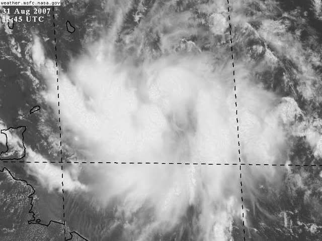
Zardoz wrote:Meanwhile, 94L continues to look more impressive with each passing hour:
GOES East Rainbow
GOES Floater One Rainbow
Coredesat wrote:Zardoz wrote:Meanwhile, 94L continues to look more impressive with each passing hour:
GOES East Rainbow
GOES Floater One Rainbow
It does look good, but try not to use the rainbow channel as it exaggerates cloud top temperatures.
CrazyC83 wrote:Imagine the embarrasment AccuWX will face if the Recon comes back finding a wave?


Emmett_Brown wrote:I think this is a TD, but i have thought that before, and seen recon come back unable to close off a center. I think recon will find a closed LLC today, but Accuweather will look kind of silly if they cant close off a center.


Portastorm wrote:Just watched JB's video Big Dog for Friday. His track on unnamed system/TD6/Felix is pretty much the same as what Wxman57 and Derek are saying. He sees a strong ridge keeping the storm pretty much due west until it hits Central America.
Users browsing this forum: No registered users and 40 guests